Smart licensing in Equatorial Guinea
New awards necessitate the availability of a new regionally consistent depth-imaged seismic framework
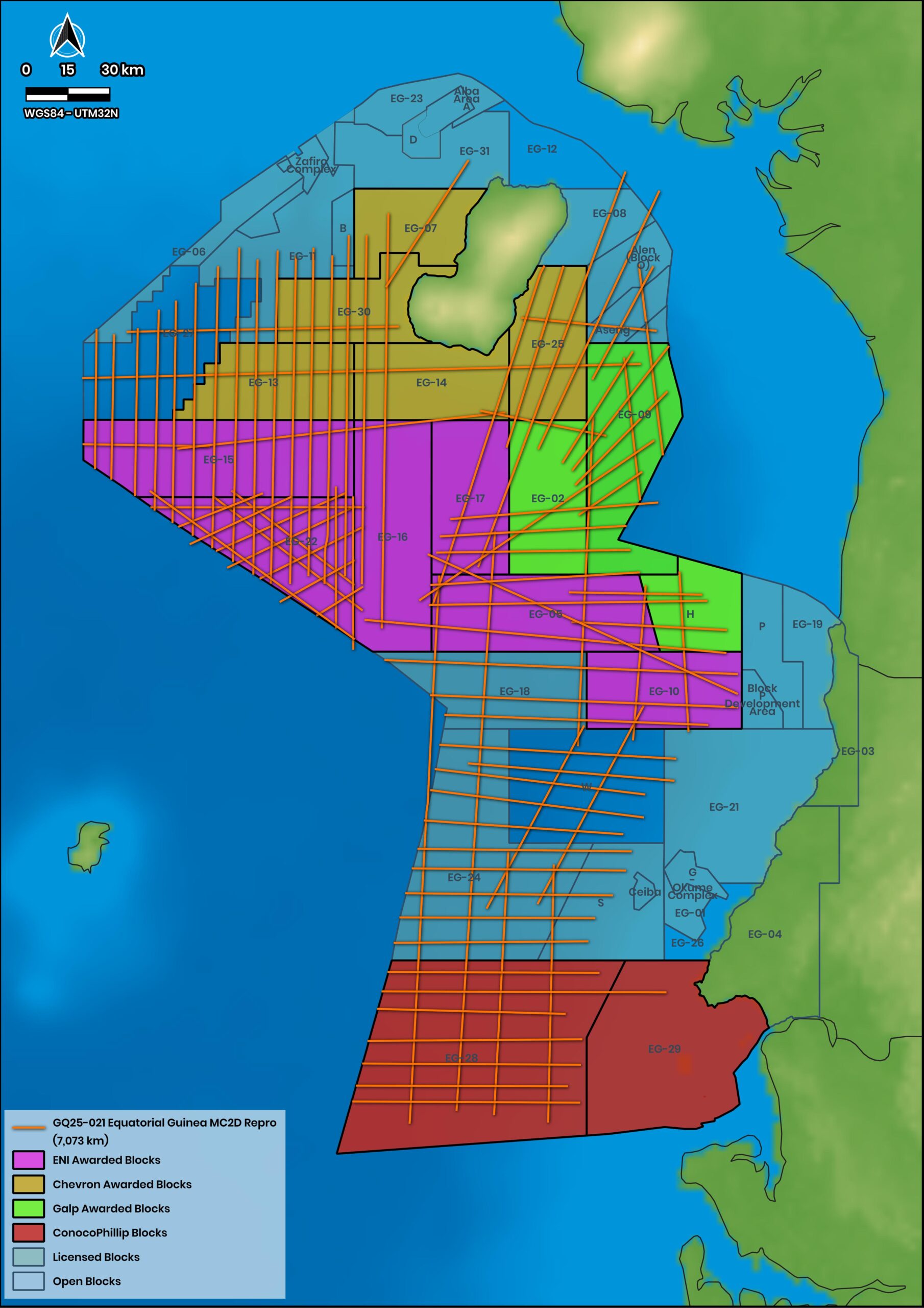
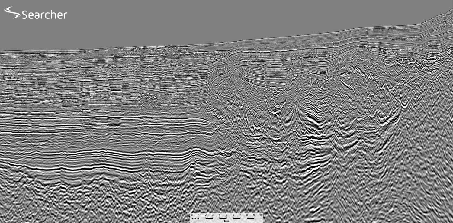
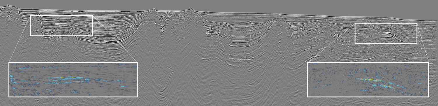
In 2025, Searcher reprocessed approximately 10,500 km of 1998 legacy 2D seismic data using broadband pre-stack depth migration (PSDM) and full-waveform inversion (FWI) workflows, undertaken by EIF. The objective was to establish a regionally consistent depth-imaged framework capable of supporting basin-scale interpretation and modern exploration workflows.
The resulting dataset provides the only coherent regional framework into which legacy 3D surveys can be integrated and sets the scene for a new strategically important understanding linking the proven hydrocarbon systems of Cameroon, Gabon and São Tomé and Príncipe to the deeper water areas of Equatorial Guinea. The reprocessed regional dataset, with flattened gathers yielding reliable angle stacks, now allows AVO character to be examined across the basin, improving understanding of both sediment routing systems and source rock distribution and subsequent hydrocarbon migration pathways.
The deepwater basin is underlain by oceanic crust and offers a diverse range of play types. In the Cretaceous, regionally extensive early drift source rocks were deposited in the Albian and Cenomanian-Turonian, when the deepest part of the basin (the basin floor nadir) was close to where the Cameroon Volcanic Line (CVL) sits today. Hence, all clastic turbidite systems cascading into the basin from the north, east and south all flowed from constrained slope channel systems onto the basin floor.
Basin floor fans were deposited by the reduction in flow velocity at the base of slope, with the associated channel belts deflected or halted by topology on the pervasive set of transform faults running NE-SW across the basin. The CVL volcanism commenced towards the end of the Cretaceous, slowly lifting the central basin floor through the Tertiary from nadir to acme, building the CVL islands and creating counter-regional dip trapping configurations to stratigraphic traps.
Plays in the North
In northern Equatorial Guinea, at the toe of the Niger Delta, exploration has previously focused on the structural traps in the east-west oriented Gravity Driven Fold and Thrust Belt (GDFTB), where the giant discoveries of Zafiro and Alba were made in the 1990s. In front of the GDFTB, within this play, are the large but shallow gas discoveries of Fortuna and Viscata, which we understand will be developed soon via the existing gas infrastructure associated with the Alba LNG development.
However, industry attention is now turning towards the deepwater areas beyond and south of these established fields, where extensive Cretaceous basin floor depositional systems sourced from the Niger Delta downlapped or were ponded against fracture zones during deposition and have now been tilted into structural traps (Figure 2).
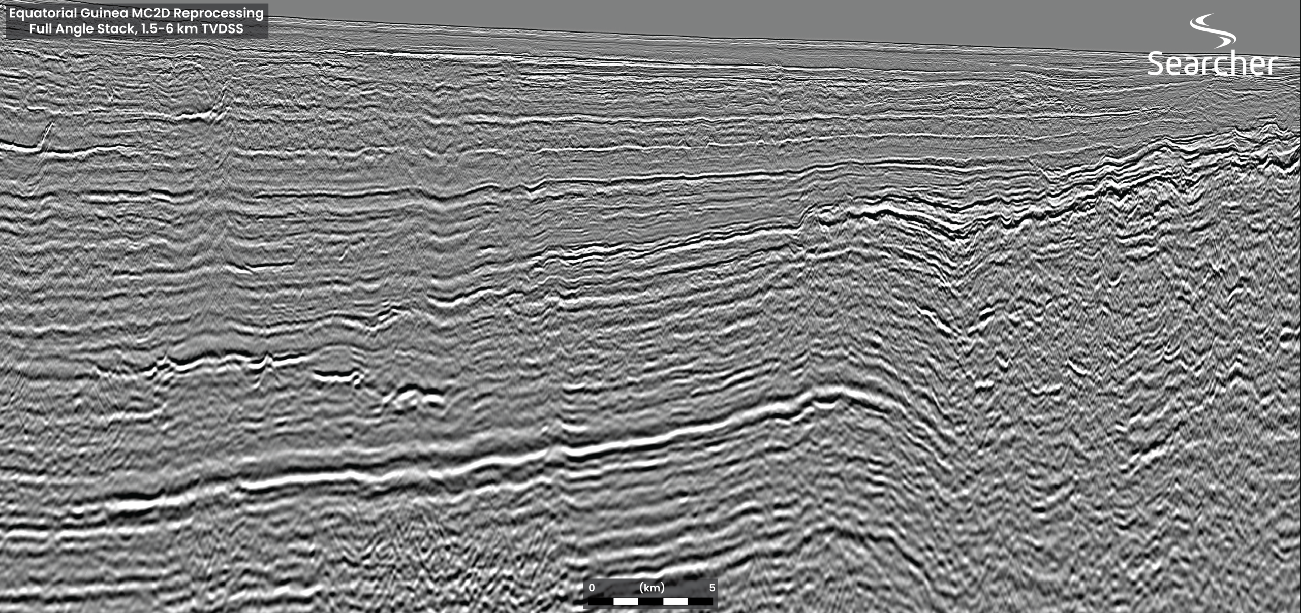
Our PSDM imaging reveals systems that were only partially recognisable on legacy seismic, identifying prospectivity, including tilted fault blocks and extensive downlap stratigraphic traps that are now in counter-regional dip configuration. Importantly, the source rock intervals responsible for charging many of the established shelf discoveries are also present within the deeper basin and can be observed through frequency content and amplitude vs offset character (AVO). The combination of proven charge, improved reservoir prediction and more clearly imaged trap geometries significantly enhances the attractiveness of these northern deepwater play fairways.
Deepwater and sub-salt plays in the South
The southern sector of Equatorial Guinea contains a distinctly different exploration character. Here, sediment transport systems that formed the Ceiba channel extend basinward into deepwater settings, delivering substantial volumes of clastic sediment into basin floor environments. Reprocessed seismic data reveal channel-levee complexes, basin floor fans and structurally influenced sediment fairways that can now be mapped with considerably greater confidence than was possible using earlier datasets. Just as it has north of the CVL, fracture-zone topography appears to have exerted an important influence on sediment routing and reservoir distribution throughout this region.
Sediments flowing north down slope from Ceiba hit transforms and either pond or get deflected to run west along the fracture zone topology.
One of the most significant outcomes of the reprocessing programme has been the improved imaging beneath areas affected by the northern extension of the Gabon Salt Basin. Enhanced velocity modelling has transformed the understanding of the sub-salt section, allowing previously poorly resolved intervals to be interpreted with greater confidence (Figure 3).
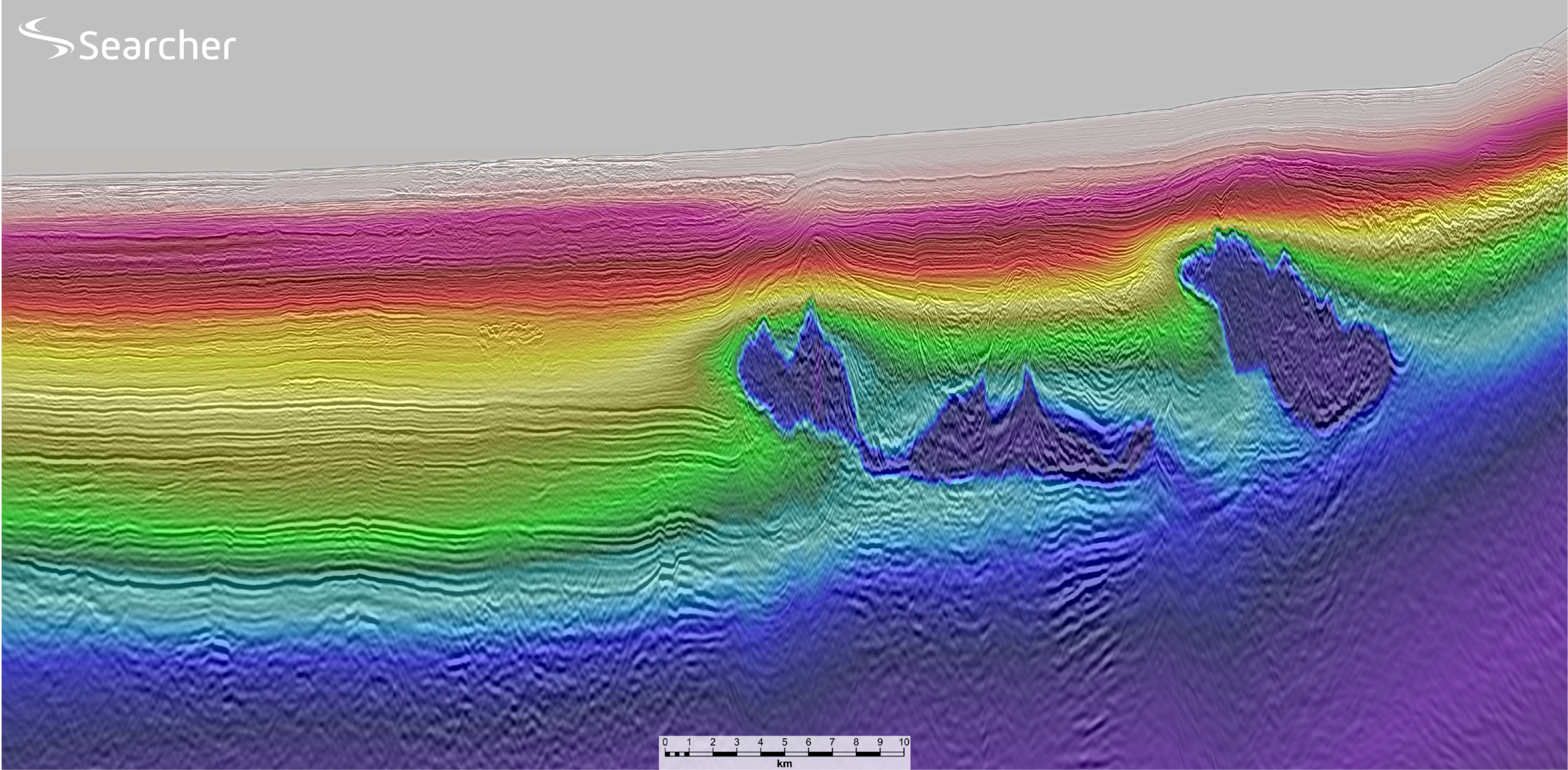
A key advantage of the reprocessed dataset is its ability to place Equatorial Guinea within a broader regional geological context. To the east, petroleum systems associated with the N’Tem Block of southern Cameroon extend across international boundaries into Equatorial Guinea’s offshore acreage, particularly within Blocks 02, H and 09. To the west and southwest, sediment transport systems and structural trends continue towards São Tomé and Príncipe, where recent drilling activity has renewed interest in the region’s exploration potential.
The regional seismic framework demonstrates that many of the geological processes controlling reservoir distribution, hydrocarbon generation and migration operate across national boundaries. Understanding these regional relationships is therefore critical to evaluating exploration risk and identifying the most prospective fairways.
The exploration objective remains unchanged: the identification of large, high-quality reservoirs within robust trapping geometries supported by proven hydrocarbon charge. No part of offshore Equatorial Guinea is greater than 2,400 m of water, so even “deepwater” isn’t that deep. What has changed and initiated this pursuit of acreage in Equatorial Guinea is the industry’s understanding that the last truly significant hydrocarbon prospects lie where they haven’t yet been hunted; in deeper waters in basins where the key risk elements of hydrocarbon systems have been proven, and prospects can be big, simple and permeable.
Searcher is also driving forward with plans for new acquisition, both over the few remaining areas where legacy 3D does not exist but also where the aged lagacy data was acquired with short streamer.
The recent licensing awards demonstrate growing confidence in the basin’s remaining potential. Supported by a modern regional seismic framework and an improved geological understanding of deepwater play systems, Equatorial Guinea is entering a new phase of exploration in which seismic can blaze the path for explorers with more confidence than at any previous point in the basin’s history.