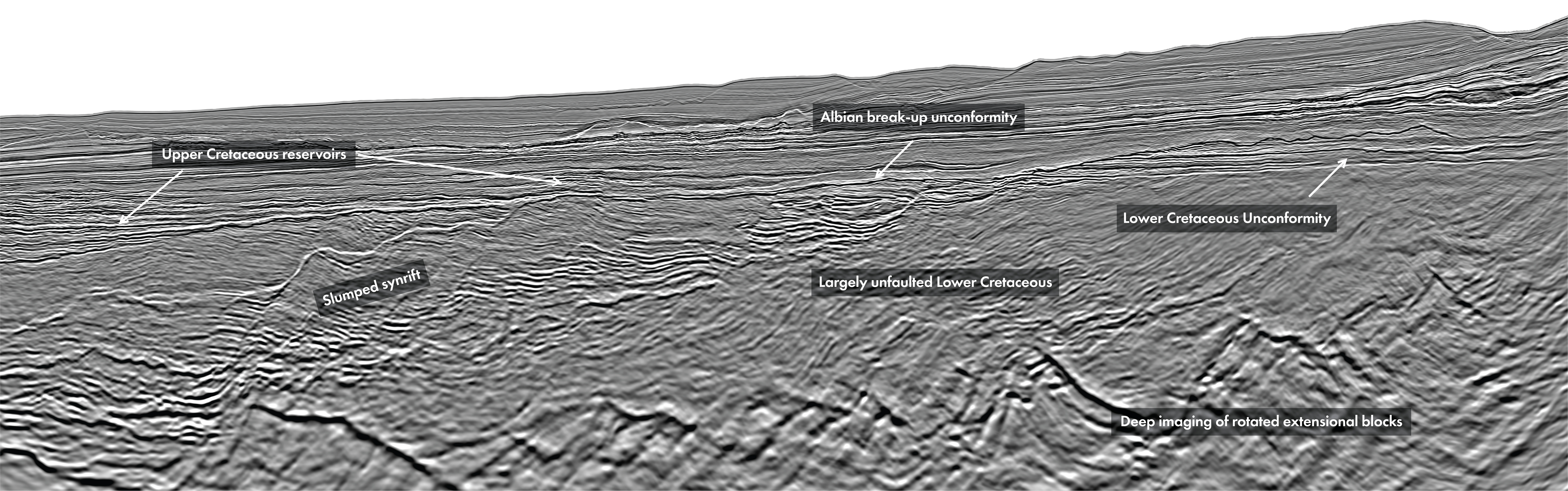
Long overshadowed by its shallower counterparts along the West African Transform Margin, the deep-water basin of northern Sierra Leone holds a remarkable geological secret. This unique margin preserves a polyphase tectonic history where Jurassic foundations from the Central Atlantic break-up, which formed the prolific Guyana-Suriname Basin, were later overprinted by the Lower Cretaceous South Atlantic transtensional opening. This complex structural inheritance did not just shape the seabed – it directly dictated the plumbing of ancient sediment pathways, carving out prolific opportunities for exploration. Now, armed with newly acquired, state-ofthe-art 3D seismic data, we can peer deep into this multi-stage architecture for the very first time. The deep waters of northern Sierra Leone represent one of the least explored parts of the West African Transform Margin (WATM), where exploration has historically focused on shelf and upper-slope environments. In 2025, GeoPartners, BGP and PSDL acquired nearly 3,000 km2 of modern 3D multi-client seismic data in the area, providing a new perspective on the deeper-water basin architecture and associated petroleum potential. In May 2026, the final PSDM data became available, which has allowed us to refine our views of the margin development Traditionally, the WATM has been considered to be a Lower Cretaceous aged mega-regional feature; these new data show how at the far western end of the WATM, the margin is shaped not by a single rifting event, but by the interaction of two distinct Atlantic opening phases. The first was the Jurassic Central Atlantic break-up, which established an inherited tectonic framework. This was later reactivated and overprinted during the Lower Cretaceous opening of the South Atlantic, producing the transform and extensional architecture that characterises the modern Sierra Leone margin. Northern Sierra Leone occupies a particularly important position at the western end of the South Atlantic rift system. Unlike many parts of the WATM, the region retains a strong imprint from the earlier Jurassic Central Atlantic rifting phase. During the Lower to Middle Jurassic, the Central Atlantic break-up was accompanied by significant magmatism, with large volumes of volcanic material associated with the formation of the Guinea and Demerara Plateaus and the Bahamas Bank. Although Northern Sierra Leone was not located directly above the main magmatic centre, it was positioned close enough to preserve elements of this earlier rift system. Seismic data indicate the presence of deep, high-amplitude rift-related packages and faulted structures interpreted as remnants of this Jurassic architecture. These inherited structures formed the foundation upon which later Cretaceous tectonic processes operated. Following the Jurassic rift event, the region underwent a post-rift passive subsidence during which a progradational and aggradational succession was deposited over the area which now makes up the Northern Sierra Leone margin. The second major phase occurred during the Lower Cretaceous, when the South Atlantic began to open. This event created the principal architecture of the present-day WATM, with segmented rift and transform zones developing as Africa separated from South America. Northern Sierra Leone sits at the end of one of these extensional segments (Figure 1). Break-up occurred around the Early Cretaceous, producing the margin geometry observed today. The Early Cretaceous rifting is localised into the distal margin where the section shows small scale slumped syn-rift faulting above a major detachment, the inner section being largely unfaulted (see Foldout). A prominent Albian unconformity separates the syn-rift system from the post-rift deposits which represent a deep-water slope environment. Here, in the transform / extensional transition zone we see a combination of structural complexity with gentler slope geometries, improved sediment retention and the opportunity for intra-slope ponding, all positive for potential hydrocarbon trapping (Figure 2). The Upper Cretaceous section represents a major exploration opportunity, particularly in the mid- to lower-slope environment. This far west on the WATM, exploration has focused on Cenomanian–Turonian reservoirs in shelf and upper-slope settings, but the deeper slope domain remains comparatively underexplored. Sitting south of the Guinea Plateau promontary at the transition from Central to Southern Atlantic, previous exploration on the shallower parts of the plateau has confirmed a viable Cenomanian-Turonian petroleum system but its deeper water extension remains unexplored and has been missing quality data coverage. The new seismic data reveal extensive Upper Cretaceous distributary systems developed above the Albian unconformity. These systems appear to have been long-lived, with multiple phases of channel development producing stacked reservoir packages in consistent locations determined by the underlying slope architecture, itself defined by the multi-phase rift architecture. To truly appreciate the evolution of these systems, one must watch them migrate and stack through the stratigraphy; scanning the QR code on the previous page opens a spectral decomposition animation (“Channel Surfing Through Time: A Spectral Spectacle”) that slices down through the seismic volume, vividly bringing these ancient deep-water highways to life. Particularly attractive are areas where slope gradients decrease, which promotes channel ponding and stacking. Channel complexes interacting with inherited bathymetric lows and subtle structural relief provide potential targets within the Upper Cretaceous succession. The deeper Lower Cretaceous section provides a different exploration opportunity. Here, prospectivity is linked directly to the syn-rift architecture created during the South Atlantic break-up. Seismic imaging suggests that Early Cretaceous deformation, driven by down-slope detachment upon earlier Lower Cretaceous deposits, created small-scale faulted structural domains, including segmented closures within larger regional closures. These structures are potentially charged by Lower Cretaceous source rocks. Northern Sierra Leone demonstrates how tectonic inheritance can shape petroleum systems over geological time. The present-day basin architecture reflects the combination of Jurassic Central Atlantic rifting and Lower Cretaceous South Atlantic break-up, producing a margin where inherited structures, rift segmentation and transform processes interact. This architecture provides the foundation for two complementary exploration play types. The Upper Cretaceous section offers extensive deep-water channel and distributary systems with stratigraphic and combination trapping potential, while the Lower Cretaceous section preserves deeper syn-rift structural targets. As exploration moves into deeper and less mature areas of the WATM, understanding this multi-phase tectonic history will be essential. In Northern Sierra Leone, the relationship between ancient rift inheritance and later Cretaceous evolution is not simply a geological curiosity — it is the key to understanding where future discoveries may lie. Explore the seismic animation: Channel Surfing Through Time – A Spectral Spectacle
The deep-water architecture of northern Sierra Leone: A tale of two oceans
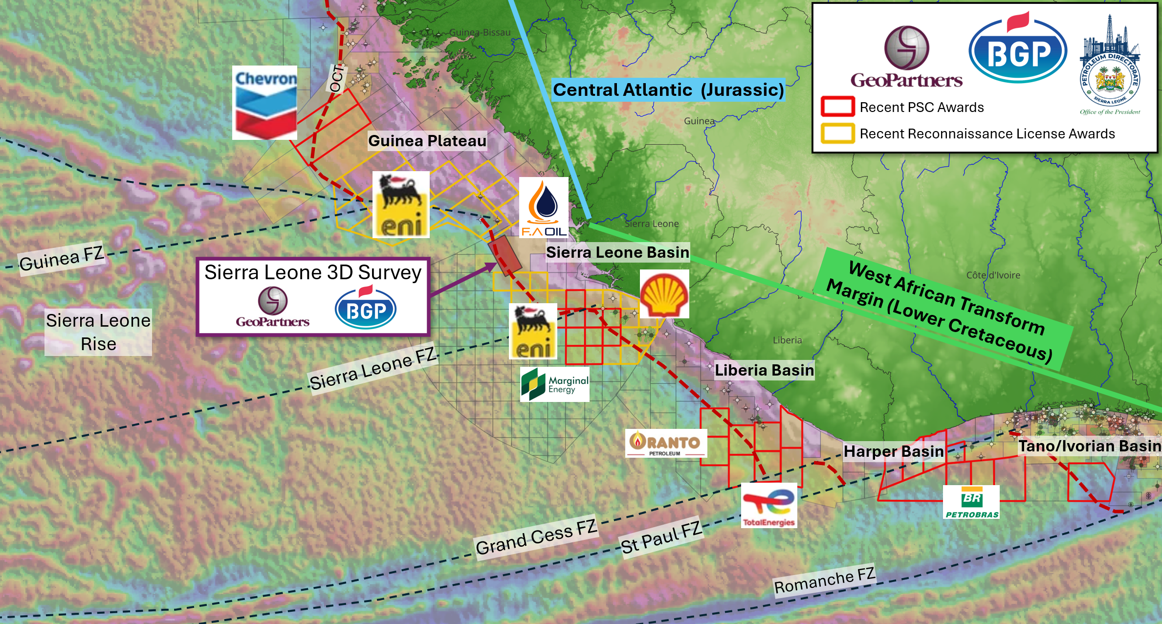
A frontier margin revealed by new data
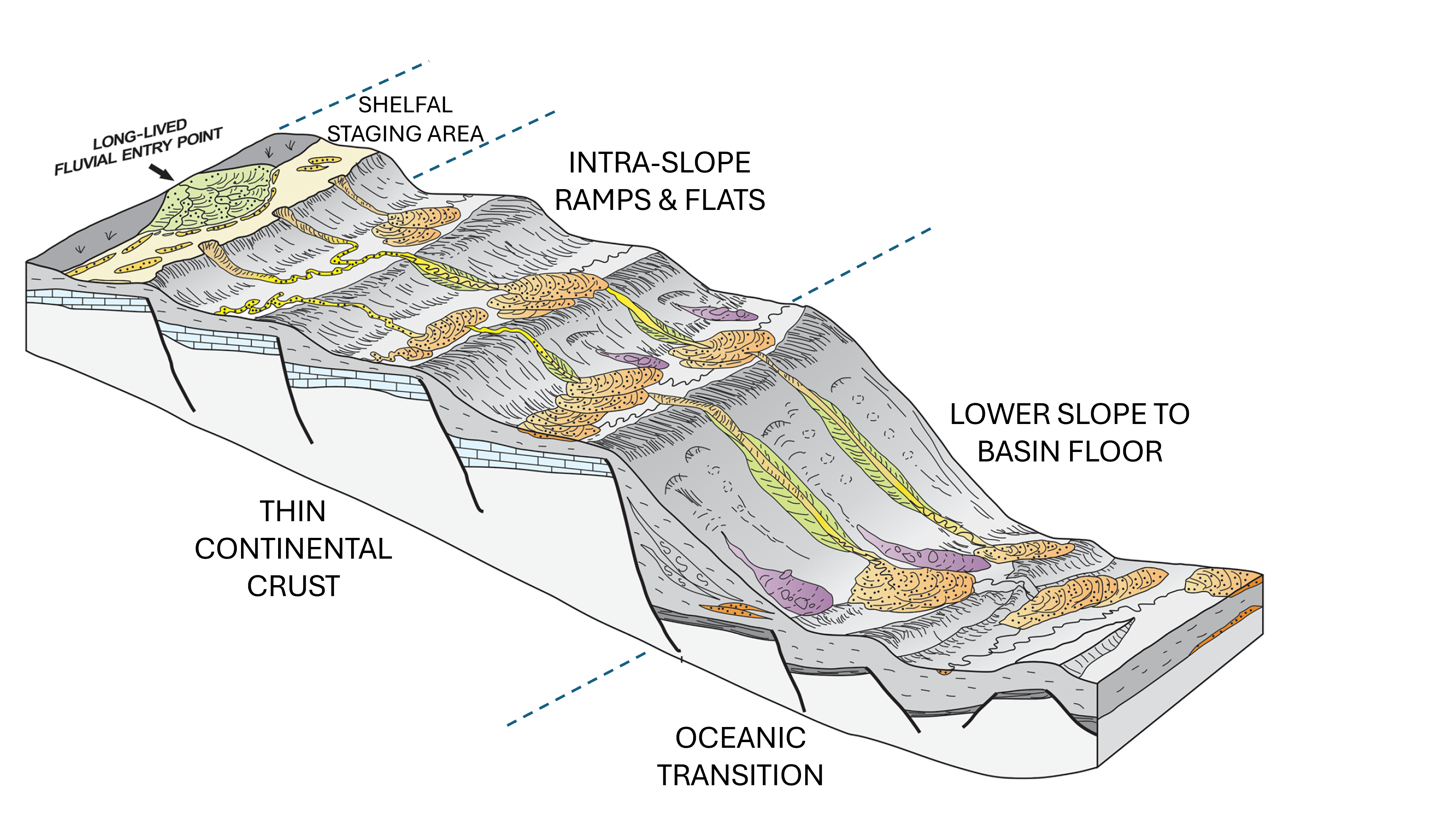
Upper Cretaceous prospectivity: Deepwater channels and stratigraphic traps
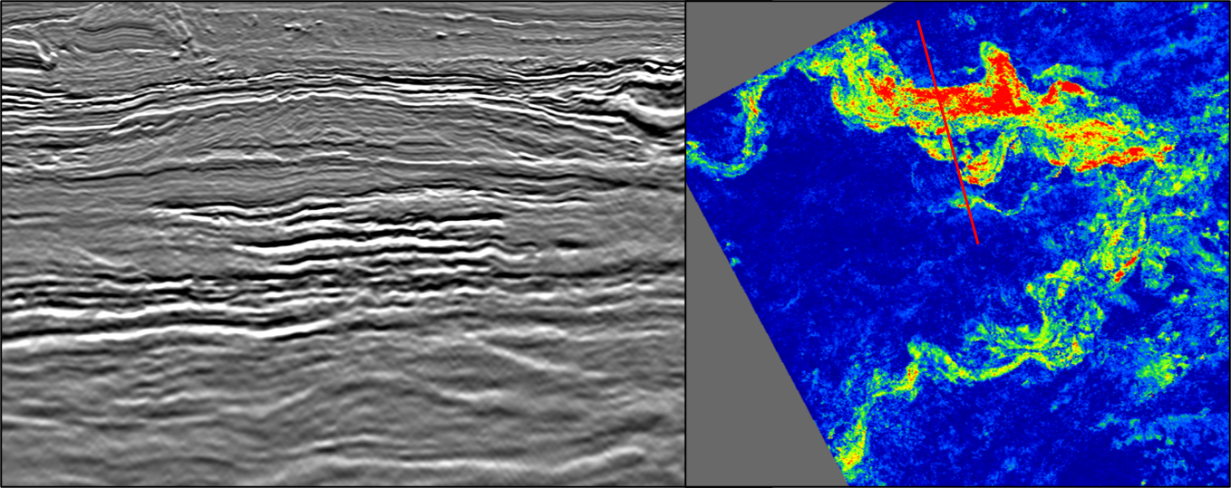
Lower Cretaceous prospectivity: Deep syn-rift structural plays
A margin defined by tectonic complexity and exploration opportunity
Related Articles