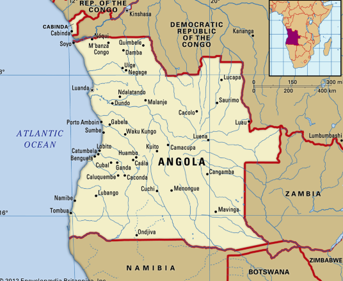
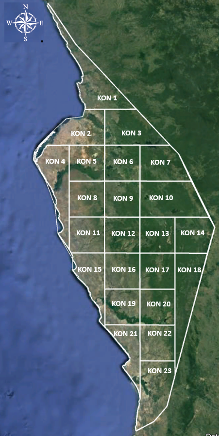
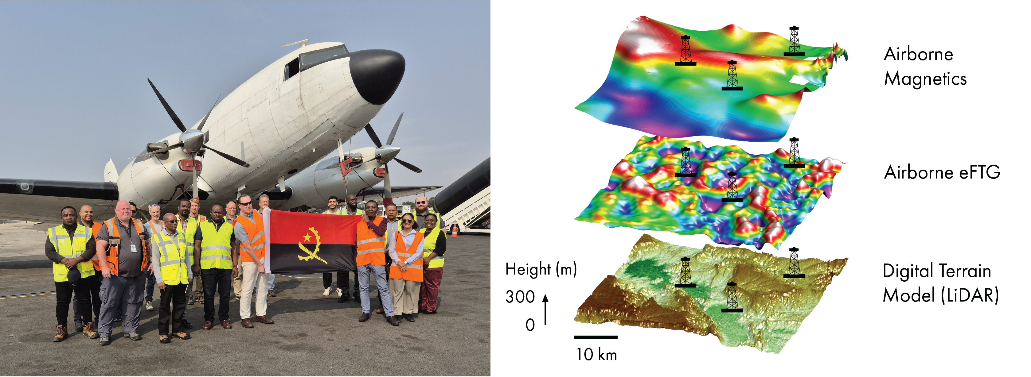
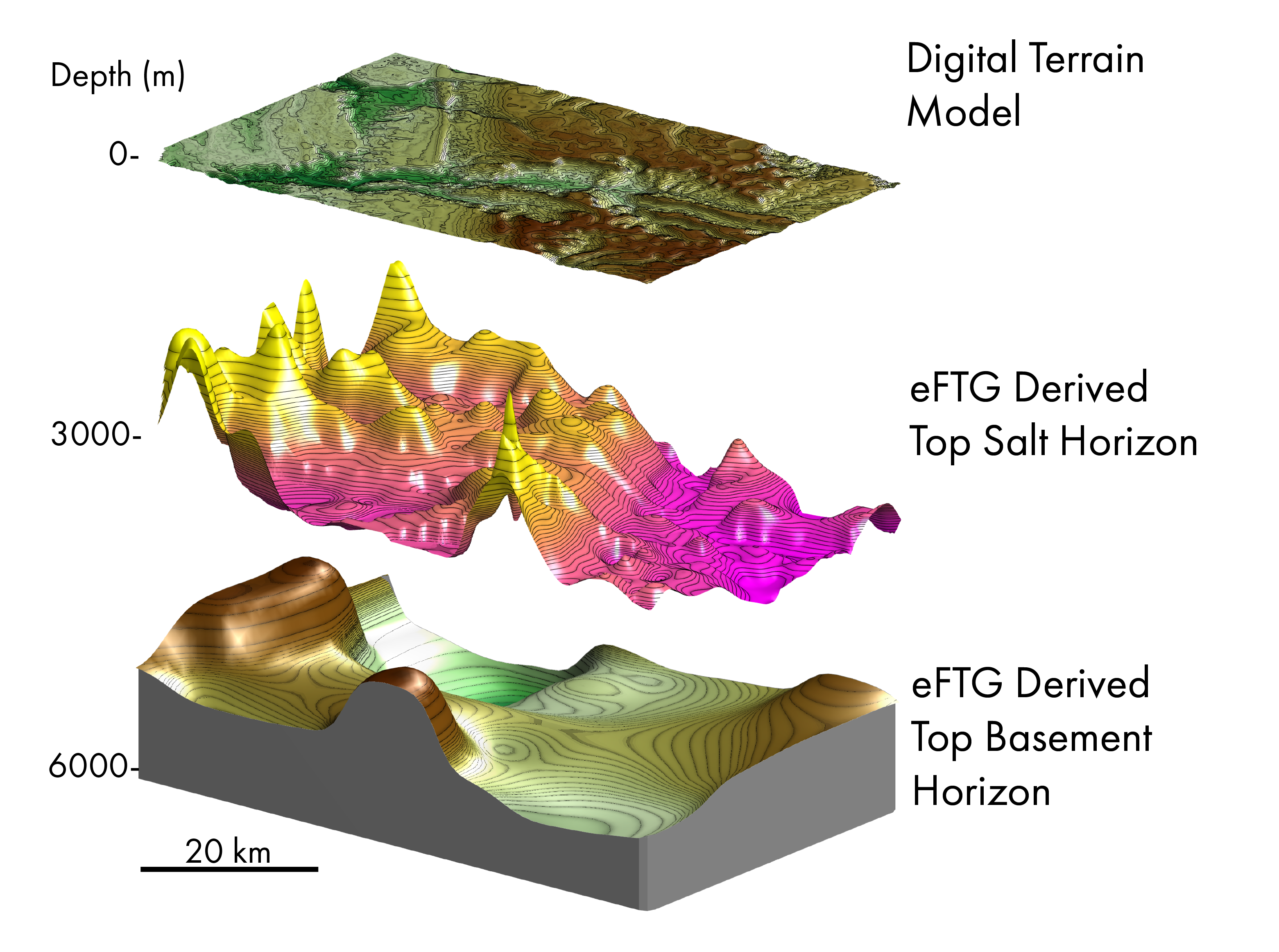
The onshore Kwanza Basin is a proven petroleum system, one of Angola’s most compelling, yet underexplored hydrocarbon provinces. More than a century after exploration first began, a new generation of airborne geophysical technologies is transforming our understanding of the basin, revealing fresh opportunities and breathing new life into one of Africa’s oldest petroleum frontiers. The Kwanza Basin has a long exploration history; however, much of its potential remains poorly understood due to sparse seismic coverage, limited well control, and imaging challenges associated with complex salt tectonics. Historically, exploration efforts have focused on post-salt objectives, leaving significant uncertainty surrounding the architecture and prospectivity of deeper pre-salt plays. Recent changes in the Angolan exploration framework have enticed both local and international operators to take a fresh look at the basin’s remaining potential. In collaboration with the Agência Nacional de Petróleo, Gás e Biocombustíveis (ANPG) and local partner Striped Horse, Metatek has successfully completed a multiclient Enhanced Full Tensor Gravity Gradiometry (eFTG) survey over the onshore Kwanza Basin. The dataset provides clarity on the subsurface basin architecture, overcoming long-standing challenges posed by limited data and the intricate nature of salt-related structural complexity. The following article explores how airborne eFTG can contribute to a more integrated understanding of the basin and its remaining exploration potential. Oil production in Angola began in the onshore Kwanza Basin, where early discoveries such as Benfica, Tobias and Quenguela North were made on seismic datasets acquired during the 1960s to 1980s. These fields produced mainly from Lower Cretaceous post-salt Binga carbonates and Miocene sandstones. However, the legacy data offered little ability to image deeper pre-salt potential. Basin production peaked at around 18,000 bbl/d in the mid-1980s before declining due to natural depletion, civil unrest and the diversion of exploration attention toward larger offshore Lower Congo Basin opportunities. Historically, the onshore Kwanza Basin has produced around 90 MMboe, and now leaves a legacy of partially developed fields, bypassed oil, and of most interest, a deeper pre salt play potential that modern geophysical technology is helping explorers reassess. In 2019–2020, ANPG implemented and executed presidential decree 52/19 for new concession licensing rounds and decree 282/20 outlining the 2020–2025 exploration strategy. These initiatives were designed to stimulate exploration and increase production in the Kwanza Basin through the adoption of new and innovative advanced survey technologies. This policy is particularly important since the basin remains data-limited, with sparse seismic coverage and persistent imaging challenges beneath thick, mobile salt bodies. As a result, understanding of the basin architecture has historically been constrained, limiting the identification of opportunities and prospects. Metatek’s Enhanced Full Tensor Gravity Gradiometry (eFTG) represents a step-change in airborne geophysical acquisition and is the most advanced, highest-resolution airborne gravity gradiometry technology currently available. By accurately measuring the gradient of the Earth’s gravitational field across all directional components of the gravity tensor, eFTG delivers exceptional geological insight from near-surface to deep basement. This enables accurate mapping of fault systems and basin architecture, improved imaging of salt distribution and tectonics, and critical understanding of pre-salt geological context. The technology provides consistent, high-resolution coverage across large areas, including regions where seismic imaging is limited or unavailable. By defining key structural trends, depocenters and potential play fairways ahead of seismic acquisition, eFTG helps operators optimise survey design, focus acquisition on the most prospective areas and reduce exploration risk before committing to higher-cost seismic programmes. These benefits are particularly relevant in the onshore Kwanza Basin, where legacy 2D seismic datasets acquired between the 1960s and 1980s are generally of poor quality and offer limited opportunity for improvement through modern reprocessing. Furthermore, new onshore seismic acquisition has limited coverage with less than 900 line-km acquired since 2012 across an area of approximately 30,000 km². To address these challenges and support planned 2027 seismic acquisition commitments, a cost-effective multiclient airborne geophysical eFTG survey was commissioned across the onshore licence areas KON1–KON23. Over a split period of seven weeks, data were acquired using a bespoke survey design. A 2 km × 5 km acquisition grid was flown across all licence areas, establishing the highest-resolution basin-wide airborne geophysical dataset currently available over the onshore Kwanza Basin. This regional framework was then supplemented by targeted infill acquisition requested by prefunding block operators, providing prospect-scale data at tighter line spacings, with the densest coverage reaching 250 m × 2.5 km. The resulting dataset significantly enhances both regional and prospect-scale geological understanding, improving interpretation of basin architecture, structural trends and hydrocarbon prospectivity, while providing a robust framework for future exploration and seismic programs. The onshore Kwanza Basin formed during the Early Cretaceous breakup of Gondwana and is an interior salt basin with pre-rift, syn-rift and post-rift successions affected by extensive halokinesis and structural deformation. Its petroleum system includes Barremian-Aptian lacustrine source rocks, fluvio-lacustrine and shallow-marine sandstone reservoirs, locally fractured carbonates, and shale or evaporite seals. Trap styles include syn-rift fault-related structures, inversion features and stratigraphic pinchouts. Whilst drilling has mainly targeted post-salt intervals, the deeper pre-salt section remains underexplored, but offers significant upside, with analogues to proven South Atlantic margin plays. The eFTG dataset provides a substantial improvement in basin-wide subsurface imaging compared to legacy data, enabling clearer definition of geological structures at both regional and prospect scales. Key insights include enhanced mapping of basement highs and lows, salt structures, and carbonate units, together with the identification of structural lineaments and improved delineation of Cenozoic basin evolution. Sub-salt imaging has been significantly improved, providing a deeper understanding of pre-salt geometry and structural complexity. Integration with seismic and well data support the development of more robust geological models, helping to reduce uncertainty and improve confidence in prospectivity. These results are consistent with global applications of airborne gravity gradiometry in frontier exploration. Following the successful integration of the eFTG data with legacy seismic and well data, the onshore Kwanza Basin now has a stronger technical framework for future exploration. The next phase will focus on acquiring targeted, modern seismic data over the most prospective areas identified from the integrated eFTG / seismic interpretation. Redefined trap geometries, fault relationships, salt influence and reservoir distribution can be established. In parallel, selected exploration and / or stratigraphic wells will provide critical calibration for the geophysical interpretation. This understanding will move the basin towards focused prospect evaluation and production. The onshore Kwanza Basin remains one of West Africa’s most underexplored areas, it has a proven active petroleum system and has significant pre-salt potential. While early discoveries established the basin’s credentials, exploration remains limited due to sparse seismic coverage, well control and the complexity of salt-related deformation. In response, ANPG’s renewed licensing and exploration strategy has created fresh momentum for reassessing the basin using modern geophysical technologies. Metatek’s basin-wide airborne eFTG multi-disciplinary survey, provides a major uplift in subsurface understanding. The integrated eFTG results deliver a clearer definition of basement architecture, structural trends and salt distribution: This improved geological framework helps reduce uncertainty, guide future seismic acquisition and focus exploration activity on the most prospective areas. Overall, the survey demonstrates how advanced airborne geophysics can accelerate exploration in data-limited and structurally complex basins. For Metatek and its partners, the project highlights the value of eFTG as a practical, high-resolution imaging tool with applications not only inhydrocarbon exploration, but also across wider natural resource sectors including mining, geothermal, environmental studies, agriculture and renewable energy.
Gravitating towards discoveries in Angola’s onshore Kwanza Basin
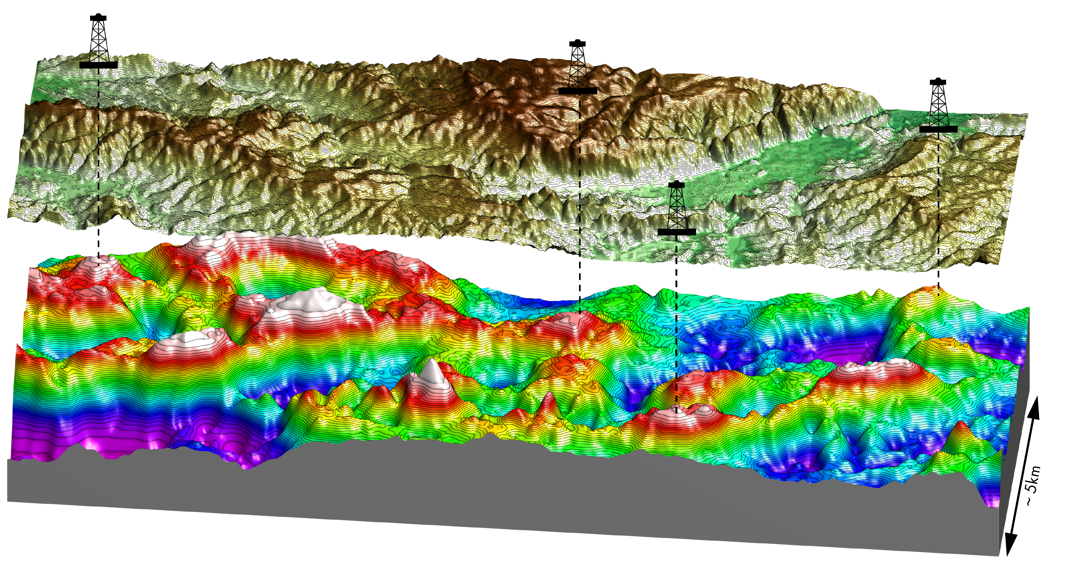 eFTG data image and overlying topography. Source: ANPG.
Unlocking pre-salt potential through integrated airborne geophysics
Cutting-edge technology brings Kwanza imaging uplift
The Kwanza Basin at a glance
Geological insights
What’s next for the Kwanza Basin?
New insights, new opportunities in the Kwanza Basin
Related Articles