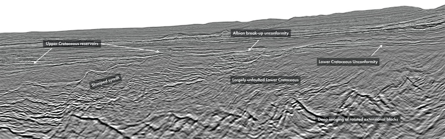
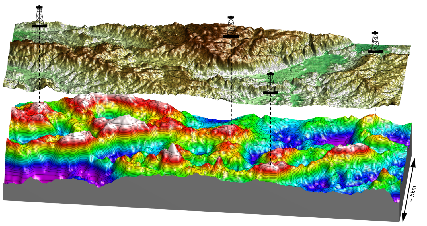
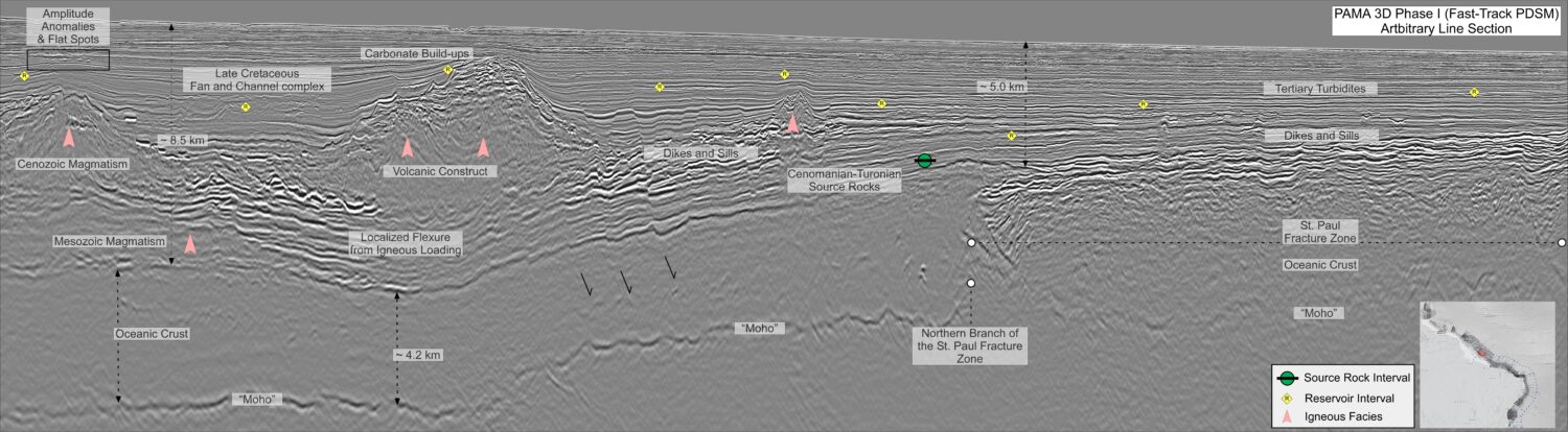
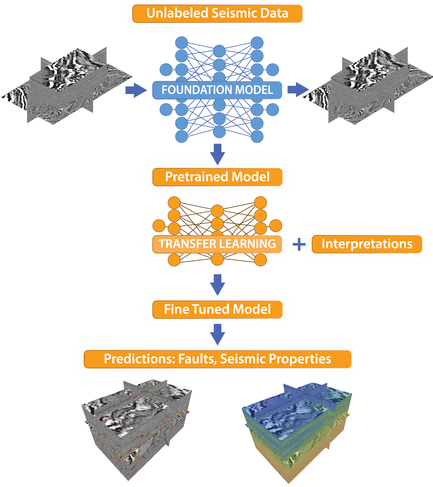
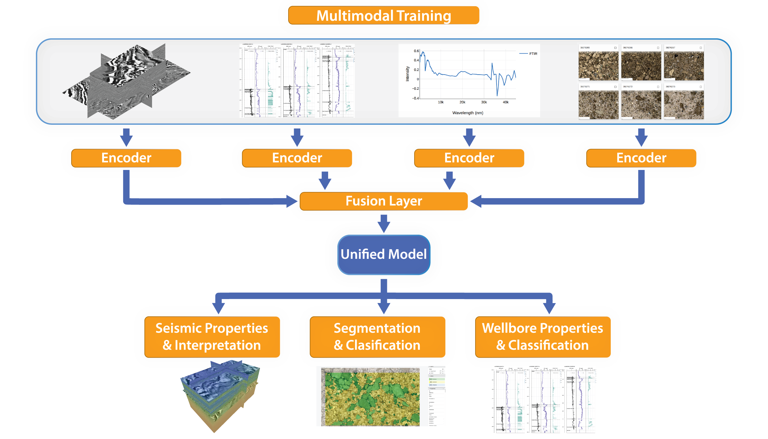
Artificial intelligence is transforming geoscience, enabling unprecedented improvements in seismic interpretation, reservoir characterization, and multi-disciplinary data integration. Traditional subsurface workflows – often slow, siloed, and constrained by manual interpretation – are being reshaped by foundation models, multi-modal learning, physics-informed neural networks, and agent-driven automation. Recent breakthroughs in seismic foundation models (SFMs), multi-modal geoscience transformers, and generative AI have demonstrated substantial gains in speed, accuracy, and generalization across surveys. These advances mark the beginning of a new era in earth modelling: One that promises holistic, continuously updating digital twins of the subsurface. Subsurface characterization has long relied on expert interpretation of subsurface rock samples, well logs, and seismic data. As datasets have become larger, and domain experts increasingly need deeper insight into complex geological heterogeneity, machine learning (ML), especially deep learning, has become essential for capturing nonlinear relationships and extracting meaningful insights at scale. ML is now central to image data interpretation, log interpretation, seismic interpretation, and reservoir property estimation from seismic (Figure 1). Four converging factors enable the rapid adoption of AI in geoscience today: The energy industry generates vast amounts of subsurface data: Seismic surveys, well logs, core samples, rock data, and geological reports. Much of this information, however, is still underutilized. The main barriers are fragmented, discipline-specific workflows, heterogeneous data formats, limited cross-disciplinary interoperability, and slow, manual interpretation processes. Advances in AI now address these challenges by integrating seismic data, text, geological maps, and numerical logs within unified analytical frameworks. AI is delivering order-of-magnitude improvements across key subsurface workflows in the energy industry, fundamentally changing both the speed and quality of interpretation. In seismic interpretation, modern AI-driven platforms such as EarthNET enable horizon and fault interpretation to be completed 20 – 200 times faster than traditional manual approaches. By automating pattern recognition and consistently applying learned geological features across large seismic volumes, these systems significantly reduce interpretation cycles while improving reproducibility and reducing interpreter bias. AI is also accelerating reservoir characterization by enabling the rapid and coherent integration of diverse data types, including core and core-plug measurements, cuttings data, well logs, and seismic volumes. This integrated approach supports the construction of consistent, multi-scale earth models that capture both fine-scale rock properties and larger-scale structural trends, leading to faster insight generation and more robust subsurface understanding. AI has now, for several years, been accelerating log editing and infill, as well as prediction of target properties based on available well logs. The ability to do this type of work efficiently and at scale has enabled basin-wide missed pay studies that have revealed overlooked exploration opportunities. Ear thNET can now integrate core photos (Figure 1B), cuttings photos (Figure 1C), thin sections, logs (Figure 1D), and geochemical data such as X-ray fluorescence (XRF) and X-ray diffraction (XRD) for more reliable classification of facies and prediction of target properties in wells. This multi-modal approach enables petrologists and petrophysicists to characterize samples and interpret well logs faster, with higher consistency, while using all the available data. The interpretation of geological timelines and age of samples is now possible using computer-vision-based fossil identification (Figure 1A) and biozone classification. Emerging, multi-modal models will soon merge fossil-derived timelines with well logs and seismic for chronological consistency, facilitating the creation of sequence-stratigraphic models based on all available data. EarthNET users can leverage machine learning methods that integrate well data with seismic information, enabling more accurate and scalable prediction of key subsurface properties. By jointly analyzing logs and seismic partial stacks, these approaches can infer elastic properties, lithofacies distributions, porosity, fluid saturation (Figure 1E), and other critical reservoir parameters across large spatial domains. This integrated learning reduces uncertainty while extending well-based insights into areas with sparse direct measurements. More broadly, machine learning represents a significant advancement in the way seismic data is mapped to underlying rock and fluid properties. Traditional empirical and physics-based workflows are increasingly complemented by, and combined with, data-driven models that can capture complex, nonlinear relationships in the subsurface. The efficient AI-assisted workflows for fault detection (Figure 1F), horizon tracking, geobody delineation, and seismic facies classification facilitate the construction of the structural and stratigraphic models that host the property volumes created from the combination of well and seismic data. As a result, ML-based techniques are improving subsurface characterization and prediction across a wide range of applications, including hydrocarbon exploration and production, CO₂ storage and monitoring, groundwater assessment, and geothermal resource development. Foundation models are large, general purpose machine learning models trained on massive amounts of diverse data and designed to be adaptable to many downstream tasks (Figure 2). The emergence of such models reduced a significant bottleneck for the efficiency of AI-assisted seismic interpretation, i.e. the strong dependence of annotated data. Self-supervised learning is the underlying training paradigm where labels are automatically derived from the data itself, rather than manually annotated by humans. Seismic foundation models have demonstrated superior performance across seismic denoising and seismic interpretation tasks compared to traditional deep learning methods. Such models can generalize across surveys without retraining. With “human in the loop” workflows, these models can reduce interpretation cycle times (up to 200 times), for tasks such as fault, horizon and geobody interpretation. Physics-informed neural networks (PINNs) incorporate governing physical laws directly into neural networks and can therefore leverage the know-ledge accumulated by researchers and domain experts. We no longer have to choose between using a physics-based approach or a learning-based approach, but can now combine both using PINNs and get the best of both worlds. Recent work in Earth Science Analytics shows that by combining physics-based methods and learning-based methods in physics-informed foundation models we can achieve improved inversion robustness, better generalization across geologies and more physically consistent predictions. Physics-informed AI bridges data driven ML with geophysical theory, transforming seismic inversion workflows. Within Earth Science Analytics, foundation models and physics-informed neural networks (PINNs) are already playing a central role in the integration of diverse subsurface data. These approaches are currently being applied to jointly analyze well-log measurements and seismic data, enabling the construction of coherent, high resolution three-dimensional volumes that describe elastic parameters and reservoir properties. By embedding physical constraints directly into the learning process, these models allow data driven insights to remain consistent with established geophysical and geological principles. Looking ahead, our ambition is to move beyond pairwise data integration toward a deeper and more comprehensive unification of geoscience disciplines. This effort will focus on the development of multi-modal geoscience foundation models capable of ingesting, correlating, and reasoning across multiple heterogeneous datatypes simultaneously. In addition to seismic volumes and well logs, these models will incorporate visual and petrophysical information derived from core images, cuttings images, and thin-section microscopy. Quantitative laboratory measurements, including core-plug data and X-ray fluorescence (XRF) analyses, will further enrich the learning process by providing direct constraints on rock properties and geochemical composition. By enabling joint learning across these complementary data modalities, we aim to create integrated subsurface representations that capture structural, elastic, petrophysical, and compositional variability in a unified framework. This multi-modal approach is expected to reduce uncertainty, improve interpretability, and ultimately support more robust reservoir characterization and decision-making in complex geological settings. Agentic AI is a promising direction for pursuing our vision of multi-modal integration of geoscientific data (Figure 3). Agentic AI leverages autonomous LLM-driven systems capable of executing multistep geoscientific workflows and creating self-improving multi-modal AI models. We believe that this paradigm can open opportunities for better utilisation of all geoscientific datatypes, further automation of QC, and better propagation of uncertainty through multi-disciplinary integrated workflows. We see a path to a future where agents can manage continuous model updates, run cross-disciplinary workflows, autonomously refine reservoir models, and support decision-makers with insights stemming from all available data. Advancements in artificial intelligence are transforming subsurface sciences, enabling the creation of high-fidelity digital twins that function as dynamic, continuously updated representations of the Earth. These living models integrate seismic, well, production, geological, and petrophysical data into a unified framework that evolves as new information becomes available. By combining multi-modal learning, seismic foundation models, physics-informed neural networks, and agentic AI, these systems support real-time scenario testing, uncertainty quantification, and automated decision-making. This convergence marks a fundamental shift away from fragmented, discipline-specific workflows toward holistic, autonomous subsurface modelling environments. As these technologies mature, they empower geoscientists to derive deeper insights, accelerate interpretation cycles, and achieve more accurate and integrated Earth models – ushering in a new era where AI is central to how we understand, predict, and manage the subsurface.
AI-driven integration for deeper subsurface insights
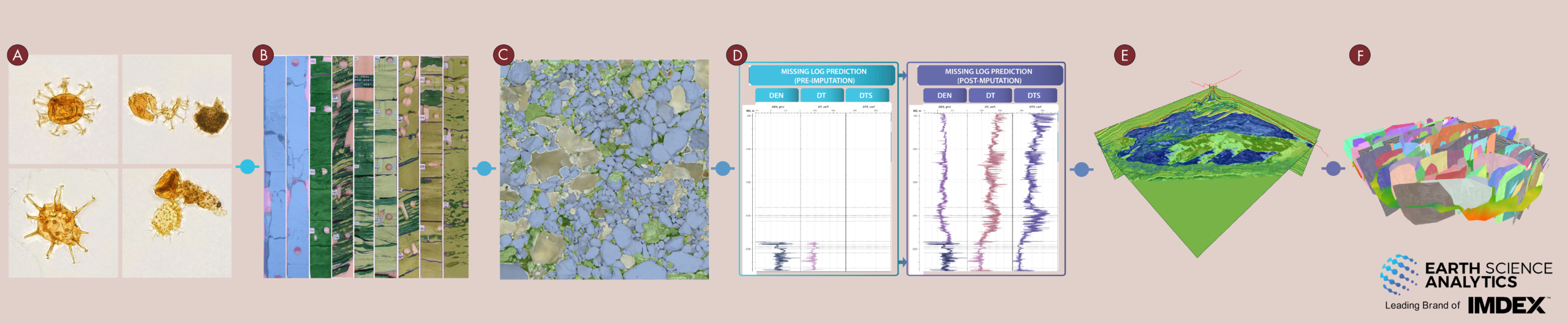 Figure 1: The cloud-native EarthNET software suite contains domain-specific AI modules for interpretation of (A) fossils, (B) core, (C) cuttings, (D) well logs, (E) seismic data for 3D property distribution, and (F) seismic data for structural and stratigraphic analysis. The AI modules are connected to the EarthNET Datalake in a way that facilitates integration through this data layer, and therefore efficient execution of multi-disciplinary workflows.
 The state of geoscience today: Challenges & opportunities
The rise of ai in subsurface workflows
Why AI now?
AI transformations across geoscience disciplines
Property prediction from well data
Property prediction from seismic
Structural seismic interpretation
Leveraging foundation models for seismic interpretation
Physics-informed neural networks
Integrating disciplines in the era of foundation models and physics-informed neural nets
The path toward autonomous workflows
Related Articles