Photo: Geofizyka Toruń.
Hybrid terrain, unified technology – GT’s land‑nodal system for high‑quality transition zone seismic data acquisition
Geofizyka Toruń has redefined the process of seismic acquisition in the land-to-sea transition zone by adapting the latest generation of land nodes for marine deployment on their own high-stability buoys. This methodology has proven successful across several high-impact projects as it eliminates traditional survey "seams" by utilising a homogeneous nodal spread
For sixty years, Geofizyka Toruń (GT) has built its reputation by pushing technological boundaries and exploring the most challenging environments in the field of global seismic acquisition. Since its earliest years, GT has consistently faced and managed operational challenges in deserts, cities, mountains, and areas where land meets the sea.
This openness has naturally led GT to become an innovator in highly complex transition zone (TZ) projects, where marine and terrestrial conditions overlap, and traditional seismic methods often fail. Tidal flats, marshlands, lakes, beaches, and shallow coastal shelves are among the least seismically explored areas due to operational complexity, cost, and the incompatibility of traditional land and marine systems.
Traditional cable-based marine equipment poses numerous operational difficulties, including heavy, specialised cables; high power demands; complex deployment procedures; and long acquisition downtime whenever failures occur. Additionally, Ocean Bottom Node (OBN) technology, though capable of delivering excellent data quality, is extremely costly and generally impractical in very shallow waters. In these areas, vessel access is restricted, and the size and weight of OBN units prevent efficient deployment.
Yet, GT has consistently accepted these challenges, developing intermediate solutions that bridge the gap between onshore and offshore environments. Over time, GT has not only adopted new methods but also actively shaped modern industry practices by reimagining how seismic data can be acquired across hybrid land-to-water terrains.
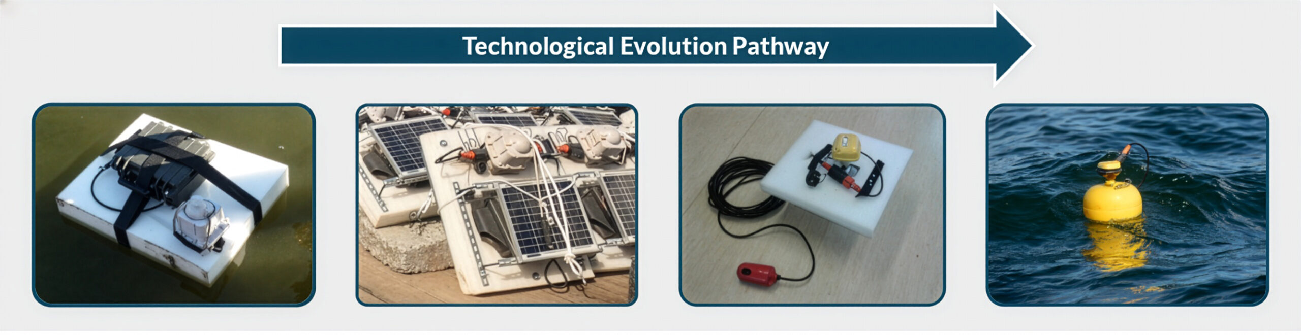
The technological evolution of our operations has shifted from heavy, cable-dependent infrastructure to agile, autonomous nodal systems (Figure 1). Initially, TZ surveys relied on specialised marine cables that presented significant operational challenges, including power supply issues, high failure risks, and complex retrieval processes that often resulted in costly downtime.
The first step toward a more flexible approach was the introduction of foam-based floating platforms equipped with early wireless recording units. While these units were effective in calm waters and lakes, their heavy battery requirements dominated the platform’s mass, limiting their use. However, frequent battery swaps remained a logistical bottleneck until GT integrated solar panels into the design, enabling uninterrupted, long-term operations in remote marine environments. This system was first deployed internationally in the 2020 UAE Block 5 project, where nearly 1,000 platforms were deployed up to 8 km offshore.
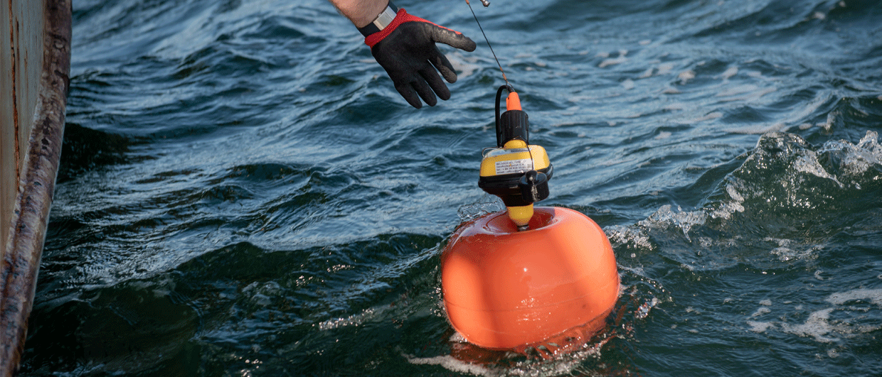
The arrival of the latest generation of land nodes marked a definitive turning point in GT’s engineering strategy. Originally designed for land use, these lightweight, high-endurance nodes were seamlessly adapted for marine conditions by housing them within custom-engineered, streamlined buoys. Unlike earlier platforms, these second-generation buoys are specifically designed for unsteady, wave-affected waters. Each buoy features a surface-mounted node powered by internal batteries, a counterweight ballast for stability and GNSS receiver for precise timing and positioning. The node is linked to a hydrophone resting on the seabed, enabling independent data storage and high-fidelity recording. GT utilises Low Power Wide Area Network (LPWAN) technology to ensure data integrity, enabling near real-time remote health monitoring of the spread.
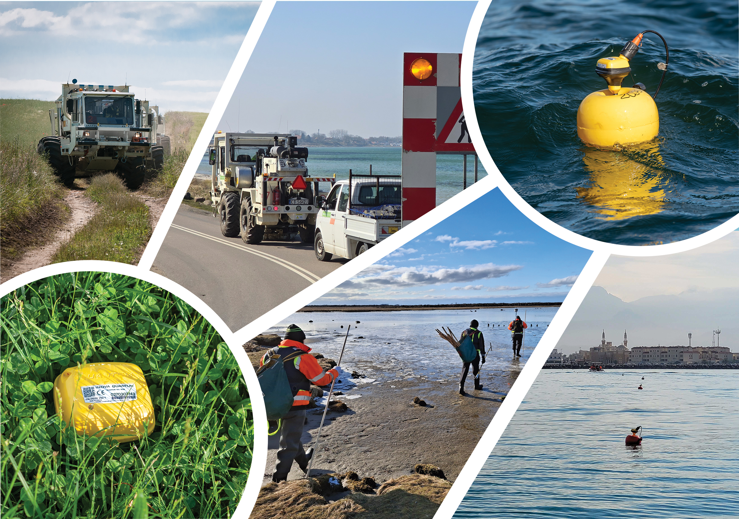
These technological advances have resulted in a series of successful large-scale projects, each of which demonstrates the effectiveness, reliability, and cost-efficiency of GT’s land-nodal maritime solutions. The robustness of this approach was first validated through thorough implementation tests in the Baltic Sea during the harsh winter of 2023. Despite sea states reaching 9 – 10 on the Beaufort scale, the buoys maintained exceptional positional stability, with coordinate deviations of only a few meters. This reliability paved the way for international commercial success.
In the UAE Block 6 project (2023), GT successfully navigated a highly complex 615 km² area, with the offshore marine acquisition zone covering over 47 km². GT’s system scalability was further demonstrated in the Baltic Sea during the Białokury 3D and Biesiekierz 3D surveys for ORLEN S.A. In the Białokury project, which covered 338 km², of which 79 km² were offshore, GT integrated nearly 1,000 marine hydrophone buoys and over 25,000 land geophones into a single, seamless acquisition grid extending up to 6 km from the coast (Figure 3).
The Kalundborg 3D project (2025) for Equinor, Ørsted, and Nordsøfonden in Denmark marked a new milestone for this methodology. The survey covered a total area of approximately 182 km², including a 47 km² offshore zone across Nekselø Bay. Designed to evaluate the suitability of the subsurface for carbon capture and storage (CCS), this offshore segment utilized 1,842 buoy-mounted nodes. Near real-time node status control was maintained via LPWAN technology, and GNSS-based positioning ensured precise receiver coordinates despite variable bathymetry and strict environmental regulations. Despite complex vessel logistics and changing sea conditions, the system proved exceptionally robust, with only four buoys lost throughout the entire offshore campaign.
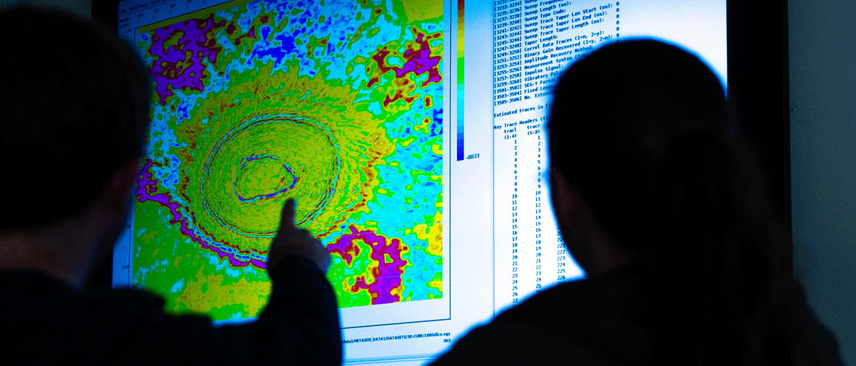
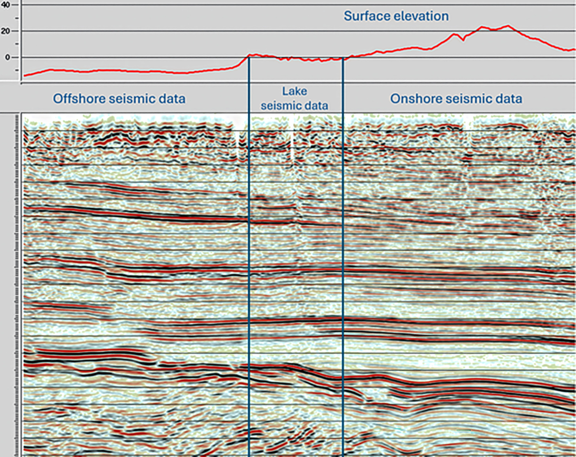
The ultimate validation of GT’s nodal-buoy strategy can be seen in the final seismic product. GT has eliminated the discrepancies and “seams” typical of multi-environment surveys by using a homogeneous nodal system across land, lake, and marine environments. The data quality from buoy-mounted land nodes is comparable to standard onshore acquisition, providing seismic sections that remain uniform across environmental boundaries. After applying proprietary drift-correction algorithms and elevation statics, reflector continuity becomes seamless with no visible transition artifacts. This consistency, along with substantially lower operational costs compared to conventional OBN or cable-based systems, highlights that GT’s solution is not only technically top-notch but also economically appealing. GT has refined its method for acquiring high-quality seismic data in previously inaccessible areas over the years, providing unmatched continuity across all segments of the Transition Zone.
References:
Clark, A., Trela, J., Potepa, P., Ziółkowski, S. and Pavel, D. [2025]. Developments in nodal data acquisition in the transition zone and shallow water. First break, 40(1), 51-56
Potepa, P., Souissi, K., Beitz, M., Zubrzycka, E., Trela, J. [2026]. Redefining transition-zone 3D seismic acquisition: Flexible land-nodal methods applied to the Kalundborg-Gassum CCS site, Denmark. First break, 44(1), 67-71