Galibi, Suriname. Photo: Rico van Manen via Adobe Stock.
Spatial variation in charge risk along the Guyana-Suriname margin
Results of a new basin modelling study

The Guyana-Suriname Basin is a Mesozoic rifted-passive margin along the northeastern coast of South America that has emerged as one of the most prolific deepwater petroleum provinces of the past decade. Since the Liza-1 discovery in 2015, the central play fairway, or “Golden Lane”, has been established by more than 54 discoveries. Production from the Golden Lane has increased to 900,000 bbl/d and is sourced from stacked Upper Albian through Coniacian – and locally younger – marine source rock acmes. A source rock acme is a specific, geologic time interval commonly lasting millions of years that marks the preferential deposition and preservation of marine organic matter. Despite the remarkable discovery of the Golden Lane in Guyana, the eastward extension of the play fairway 300 km into offshore Suriname remains uncertain, as recent Suriname wells have failed to encounter commercial petroleum.
Source rock potential of the Demerara Plateau
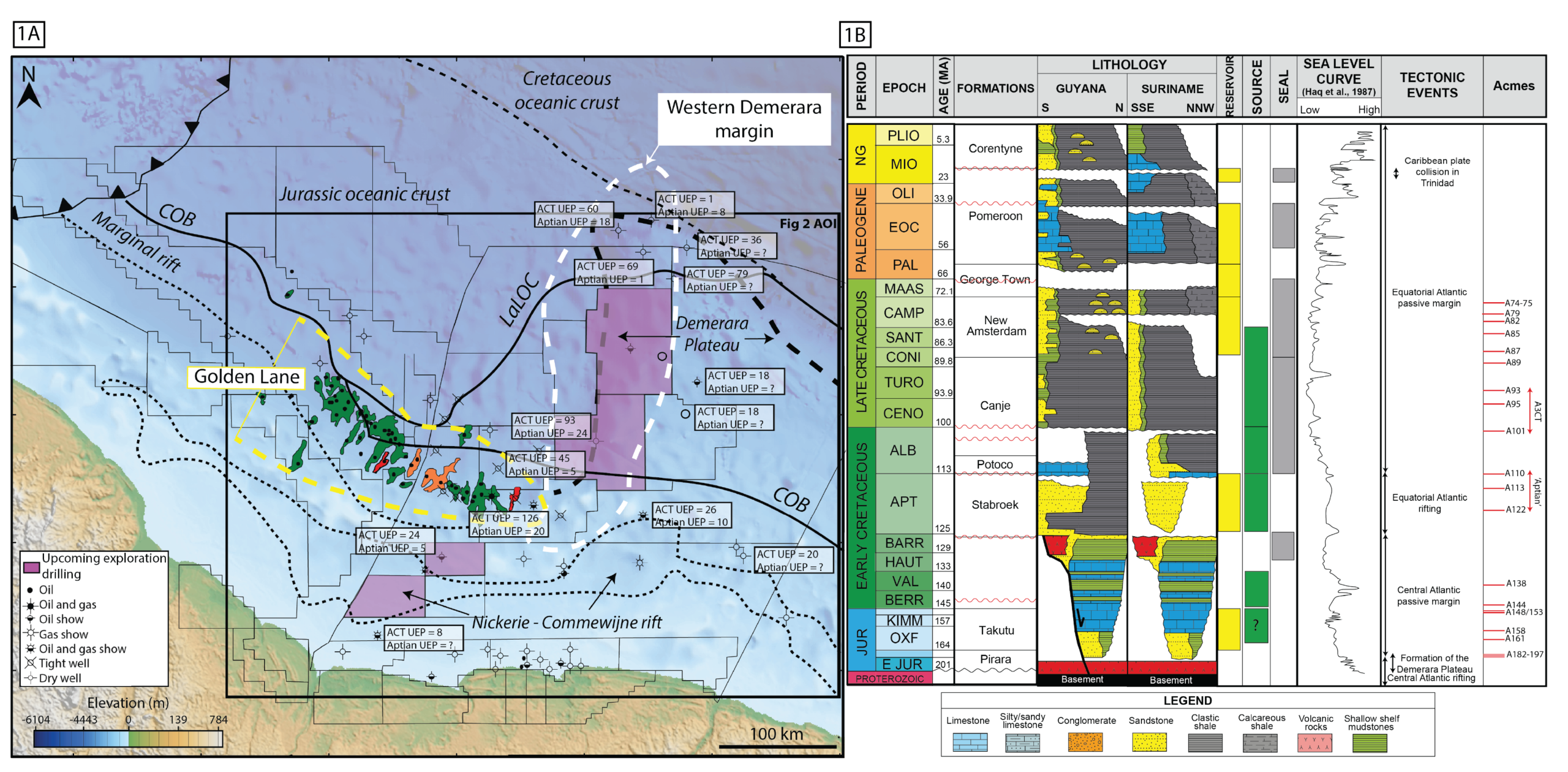
In the first step of charge risk evaluation, we compiled published Rock-Eval pyrolysis data from exploration wells on the present shelf and upper slope, including data from five deepwater Demerara Plateau sites drilled in 2003 during Leg 207 of the Ocean Drilling Project. We augmented this with combined Cenomanian-Turonian Acme Ultimate Expellable Potential (UEP) values from the Staatsolie Atlas of Suriname (2025).
Multiple source rock acmes in both the Aptian-Lower Albian (‘Aptian’) and Upper Albian, Cenomanian, and Turonian (A3CT) contain Organofacies B kerogen in marine clay-rich mudstones containing up to 15.8 % organic carbon and with a Hydrogen Index (HI) up to 730 mg HC/g TOC. This translates locally into a truly world-class UEP of up to 126 mmboe/km² for the combined A3CT.
Thermal modelling of the Guyana-Suriname Margin
The Guyana-Suriname margin is characterized by along-strike crustal variability with the Golden Lane of Guyana underlain by the 23-km-thick, non-volcanic, obliquely-rifted margin and the adjacent margin of Suriname underlain by the 25-km-thick and seaward-protruding, Demerara volcanic plateau. This crustal transition straddles the maritime boundary between Guyana and Suriname and is expressed by differences in lithospheric thickness, Moho topography, and radiogenic heat production, that combine to produce along-strike variations in source rock thermal stress.
Our full-lithosphere 3D basin model is calibrated using temperature data from seven, widely-spaced exploration wells and therefore provides an example of the value of 3D basin modeling in areas of limited data. Our basin model predicts the spatial distribution of Standard Thermal Stress (STS), resulting from variable burial histories and lateral changes in crust-lithosphere heat flow.
STS, volumes and charge fairway
Modeled STS maps for the two source intervals (Figure 2A, Figure 2B) show the oil expulsion window in green is characterized by temperatures >110° C for Organofacies B sources and extends across Blocks 52 and 58 of the western, offshore Suriname area, but does not extend northward of Block 66 in the northwestern area of the seaward-protruding, Demerara volcanic plateau. The blue area indicates an area of no expulsion. The outboard limit of the source rock kitchen only extends 40 km north of the Golden Lane for the A3CT interval. Due to deeper burial, the oil expulsion window at the Aptian level extends 120 km east and north into Blocks 63 and 64 (Figure 2B). Increasing overburden and thermal stress levels result in a gas-condensate window (yellow) and dry gas window (red) in this shallower water area, especially near the Guyana- Suriname maritime boundary.
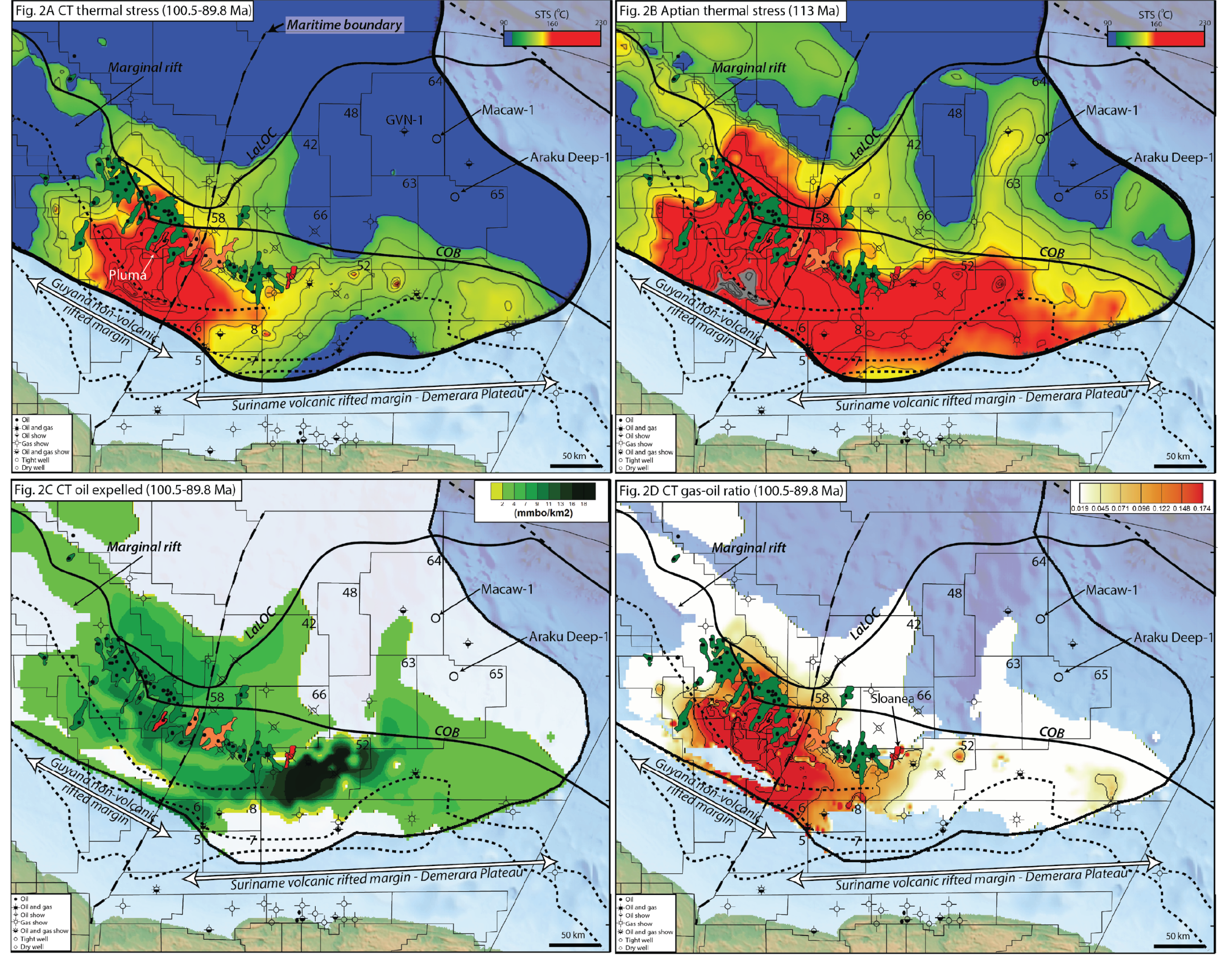
Expelled volumes of petroleum are a function of initial source rock UEP and the level of thermal stress attained. Figure 2C and 2D show expelled oil volume and Gas-Oil Ratio (GOR). In the Golden Lane area, our prediction matches the observed patterns of low GOR oil fields northwest of Stabroek (e.g. Liza), which become increasingly high GOR with vapor phase accumulations near the maritime boundary, and then become more oil-prone again along the southeastern Suriname trend (e.g. Grand Margu in Block 58). This variation in GOR is driven by variations in thermal stress that reflect the combined effects of an increase in burial depth and the higher radiogenic heat production from underlying, more granitic crust.
Note that in parts of Guyana, the model predicts a gassy charge where there are oil accumulations. This is common in many petroleum systems, and concerns the role that the trap plays in determining the GOR. Traps near gas kitchens that accumulate the whole charge history are ‘cumulative’, collecting all the charge over time, whereas a leaky or late-filled trap will behave in a more ‘instantaneous’ way, preferentially collecting the latest fluid expelled from the kitchen. This is likely a major source of the imperfect match (as well as the limited temperature calibration dataset). Mismatches where gas accumulations occur above oil kitchens, however, such as at Slonea and Araku, must be explained differently: These accumulations require a deeper source rock as predicted by the Aptian STS map (Figure 2B).
In terms of expelled petroleum volumes, the sweetspot shown by the darkest green area of Figure 2C occurs beneath the present outer shelf in Block 52 rather than in the present-day deepwater. This remarkably rich, shelfal sweetspot has fed updip migration across the hydrostatic shelf and charging of ~1 Bbbl of oil in the coastal, heavy oil fields of Suriname.
Implications for charge and migration risk in offshore Suriname
The highly productive Golden Lane of central and southeastern Guyana is associated with underlying ACT source beds with STS exceeding 120° C (Figure 2A). Our model shows that the edge of the charge fairway in northwestern Guyana may reflect the decrease in expulsion volumes from the distal offshore area, preventing the charge front from reaching shallower Cretaceous submarine fan reservoirs. This charge risk element is related to reduction in overburden thickness and/or decreasing RHP on the Jurassic oceanic crust of the deepwater area.
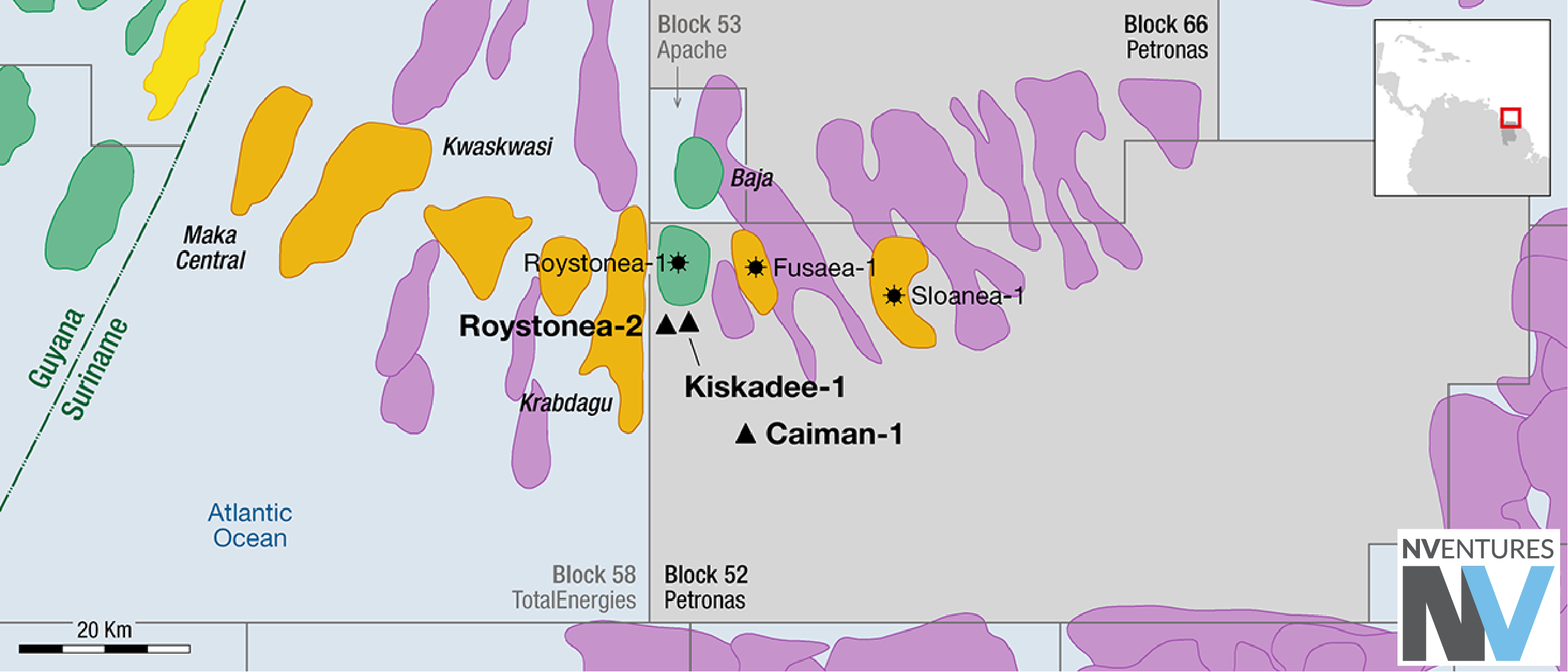
Ongoing and planned drilling of the projected Golden Lane into offshore Suriname includes the Macaw-1 and Araku Deep-1 wells, along with three upcoming wells in Block 52: They will be susceptible to this vertical migration risk. Success in these wells would support our proposed extension of the petroleum system onto the western flank of the Demerara Plateau and / or the presence of Aptian source rocks in a more expansive expulsion kitchen (Figure 2B).
Significance for exploration along the Guyana–Suriname margin
Our model delineates the kitchen limits at the Aptian and A3CT source rock intervals over a strike distance of 245 km in offshore Guyana-Suriname. While the A3CT charge fairway terminates within Blocks 52 and 58, we propose a northeastern extension of the Golden Lane kitchen onto the western flank of the Demerara volcanic plateau that is sourced by Lower Albian-Aptian source rocks. Exploration success beyond the Golden Lane of Guyana-Suriname will depend on a combination of sufficient UEP and thermal stress sufficient to overcome vertical migration losses to younger Cretaceous reservoirs.