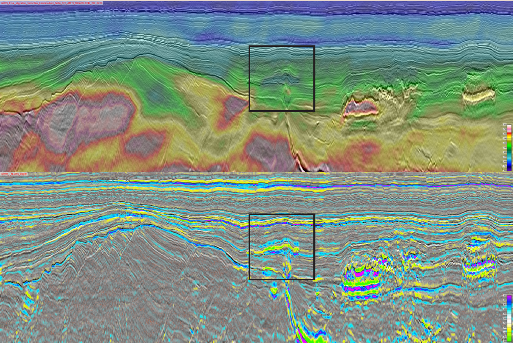
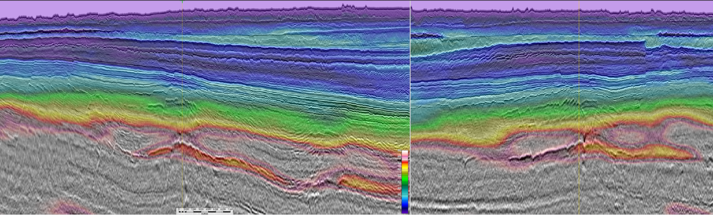
The westernmost deep-water areas of the Norwegian Sea have been explored for about 30 years. Early gas discoveries like Ormen Lange and Aasta Hansteen motivated optimism, followed by the “elephant, dome drilling period” with few successes, like Helland Hansen, Vema, Fles, Naglfar, Gjallar North and South. Thus, besides these few small gas discoveries, the potential of the deep-water Norwegian Sea still needs to be unlocked. Some answers lie in a better 3D seismic database with new tools like DM FWI’s detailed velocity volumes and better AVO screening tools like rEEI, as shown in this article and seismic foldout. According to the World Economic Forum, Europe has enough gas for the first quarter of 2023. However, there is no time to sit back, as the remainder of the year could bring new gas shortages and competition for global suppliers’ resources will likely intensify as summer draws to a close. The LNG demands from China and India could also increase, while the supply from Russia could reduce further or even cease completely. The outcome would be a larger mismatch between Europe’s needs and the global suppliers’ ability to fulfill those needs and/or their willingness based on competition for energy security. To our knowledge, there are no basins as close to a major energy market on the planet and yet poorly explored at the same time as the Møre Basin. There are two exemptions: the massive Ormen Lange field and the Aasta Hansteen field which produce gas from the northern part of the Vøring Basin. Aasta Hansteen came on stream in 2018 and it is predicted to come off plateau production this year and be shut down in 2027 if no new discoveries are tied-back to its infrastructure. As such, the Polarled pipeline and the existing infrastructure in the area are in danger of becoming a liability, while there are stranded gas discoveries toward the west. Against this backdrop, with an expected increase in demand for LNG in Europe, it is pivotal to find and develop more gas to fill the Polarled pipeline. Can the Atlantic Margin come to the rescue? In this article, we sum up what is new on the Atlantic Margin, especially how we use high-end seismic imaging and model building with dynamic- matching full waveform inversion (DM FWI) to interpret the geology and gas anomalies, alongside observations underpinning why the volcanic rocks and hydrothermal vents stimulate gas migration into traps created by the same volcanic rocks. New data and technology are revealing secrets in a formerly elusive deep-water basin explored for more than 25 years. We may soon have the answer if indeed the gas itself is generated from the heat when volcanic sills intruded organic-rich Cretaceous shales. We hope this article inspires you to do more frontier exploration in the middle of Europe! TGS, in collaboration with VBER and key clients, has worked to uncover new play models along the Atlantic Margin within the Norwegian Sea through combining research, latest subsalt technology and geological insight. In addition, during the past five years, TGS acquired approximately 59,000 sq km of modern, dense 3D streamer data (about 1,4 times the area of Denmark), thereby creating a consistent regional coverage. The surveys were processed in depth with the latest PSDM technology utilising DM FWI velocities. This has resulted in a new indicative tool where distinct slow velocity anomalies indicate existence of a gas column and reservoir quality. The extensive technical interpretation done by VBER and TGS reveals details about undiscovered intra-basin highs within the oil window, illustrating how immature these areas are. The AM19 DM FWI velocity field overlaying the PSDM stack bears interpretable details as displayed in Figure 1. The relative Extended Elastic Impedance (rEEI) volume on the right, where the gradients are extrapolated to about 45 degrees, shows robust AVO attributes. In this rEEI volume, shales and source rocks can easily be differentiated from water or gas-filled reservoirs. Using both structurally confined DM FWI slow velocity anomalies with class 3 rEEI AVO anomalies, matched and scaled as the proven Gro gas discovery (Foldout), in analogous terrain and depth, yield strong indications of new gas. Screening in this manner, we confirmed already defined leads within the now relinquished PL 1068 area on the top of the Gjallar Ridge plus more than ten structurally and stratified defined leads of various sizes. Based on the anomalous gross rock volumes surrounding Gjallar Ridge within tie back distance, our conclusion is that the total lead volumes present should be enough for a standalone development. Better seismic velocities unveil new details within flood basalts and new migration algorithms like RTM, the sub-basalt terrain. The DM FWI velocities are key to understanding the volcanic facies. Occasionally structurally confined slowness anomalies down below 3km/s sit between fast or hard layers up to 6km/s. These slow patches are interpreted as interbedded sandy sediments (potentially gas-filled), ultra-porous vesicular basalts or mud rocks. After that, there is a sharp drop in sub-basalt velocities. In the northwestern Vøring Basin, we interpret a thick Cretaceous basin below basalts. In the northern Møre Basin (AM20) we see a thinner 2-400 m slow sub-basalt layer before a rifted terrain with very high velocities indicating an old, pre-Cretaceous or even pre-Mesozoic rifting phase. Common for both places is that the slowest velocities (~2500 km/s) sit at the crest of the sub-basalt structures. There are enormous sub-basalt closures all along the Atlantic Margin, with significant catchment areas for migrating pre-Paleogene hydrocarbons. In addition, the likely pre-Cretaceous highs are located within the oil window. In support of this, a seafloor sampling cruise detected strong oil seeps above the sill intruded inner flows in the northern Vøring Basin. One of these sub-basalt targets is a candidate to be drilled. We are eagerly awaiting an announcement and new activity in this potentially highly prolific margin.
Dynamic Matching FWI + rEEI makes a difference to your interpretation
 Two 3D sections across the leads within the Gjallar High and Fenris Graben: the upper with overlayed DM FWI velocity and the lower a rEEI section scaled to the Gro 6603/12-1 gas discovery as seen in the insert. Leads within the relinquished PL 1068 license are seen to the right, and the deep 6603/5-1 S well miss anomalous events. To the left, on the northern flank of the high toward the Fenris Graben, Eocene fan systems with matching velocity slow-down anomalies and rEEI anomalies.
Gas to Europe: Refocusing exploration efforts in the Atlantic Margins
What has happened in the Norwegian Sea in the last five years?
New tools in the toolbox
Higher-resolution imaging of the geology
What’s next?
Related Articles


