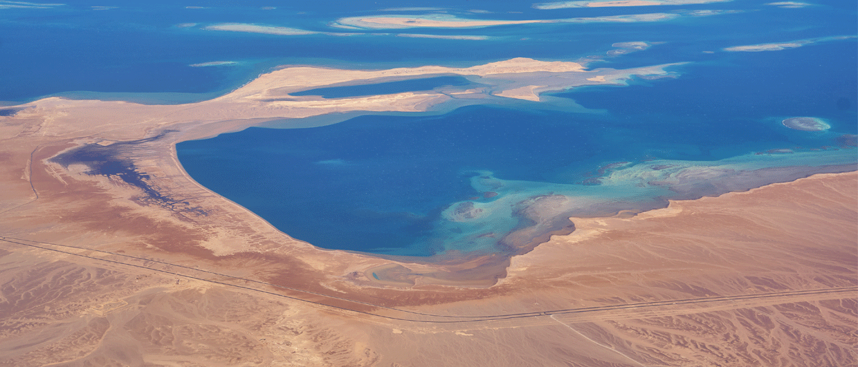
A sunset across the Mediterranean Sea as seen from Alexandria, Egypt. Source: ahmadams1978 via Pixabay
The geological context of the North Cleopatra block
Following the announcement of an oil discovery made by Shell and partners in Egypt’s Herodotus Basin, we take a look at the regional geological setting of this poorly explored part of the Eastern Mediterranean Sea

A few days ago, it was announced that the Velox-1X well, drilled in the North Cleopatra block offshore deep-water Egypt by Shell and partners, hit oil. The well, which was drilled to 6,000 m below sea level, is located in an area that has seen little drilling activity so far. For that reason, it will be interesting to have a closer look at the regional geology.
This story has benefited from a conversation I had with Peter Shiner, who has done a lot of work in the Eastern Mediterranean, as well as input from Strata GeoResearch, who kindly provided an Early Cretaceous gross depositional facies map that was used as a basis for the map shown here.
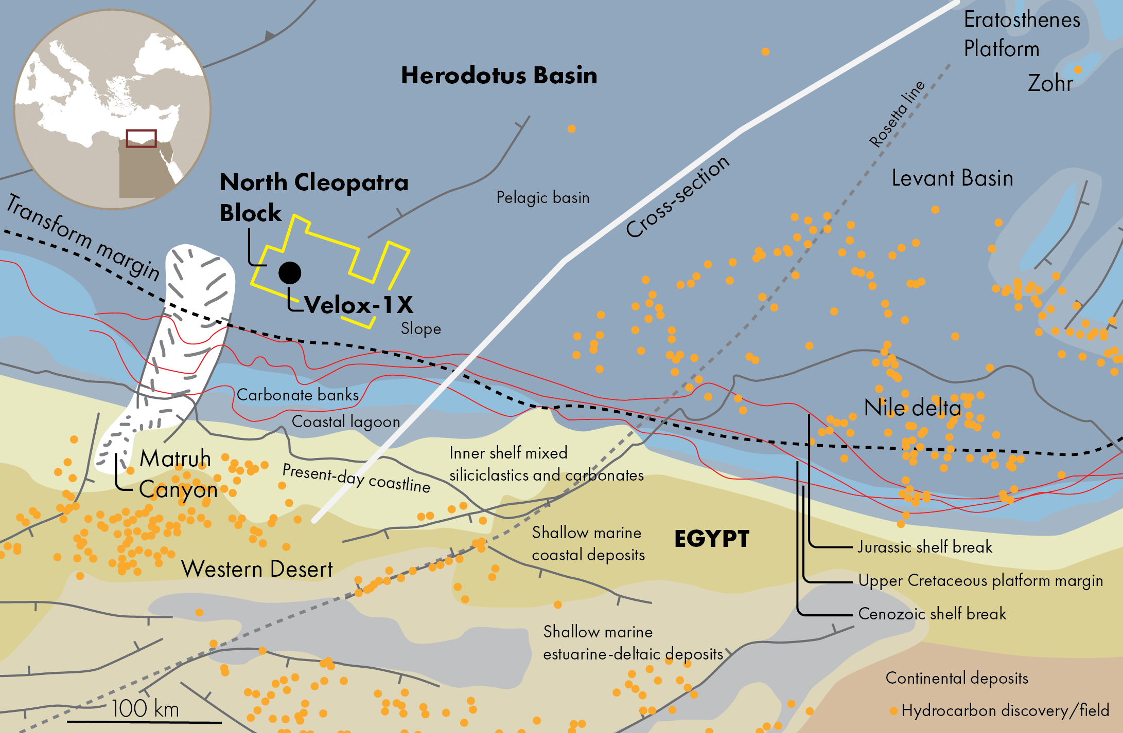
The North Cleopatra Block is situated in a poorly-known crustal setting within the Herodotus Basin. This basin came into existence during Triassic-Early Jurassic rifting, which opened along a NW-SE-trending axis. As such, the region just north of the present-day Egyptian coastline developed as a narrow transform margin. To the east, it is generally accepted that the boundary between the Herodotus Basin and the Levant Basin lines up with the Rosetta lineament, with continental crust underlying the Levant Basin. Parts of the Herodotus Basin are certainly underlain by oceanic crust, but given the proximity of the North Cleopatra Block to the transform margin, it is likely that it is sitting on extended continental crust rather than fully oceanic crust.
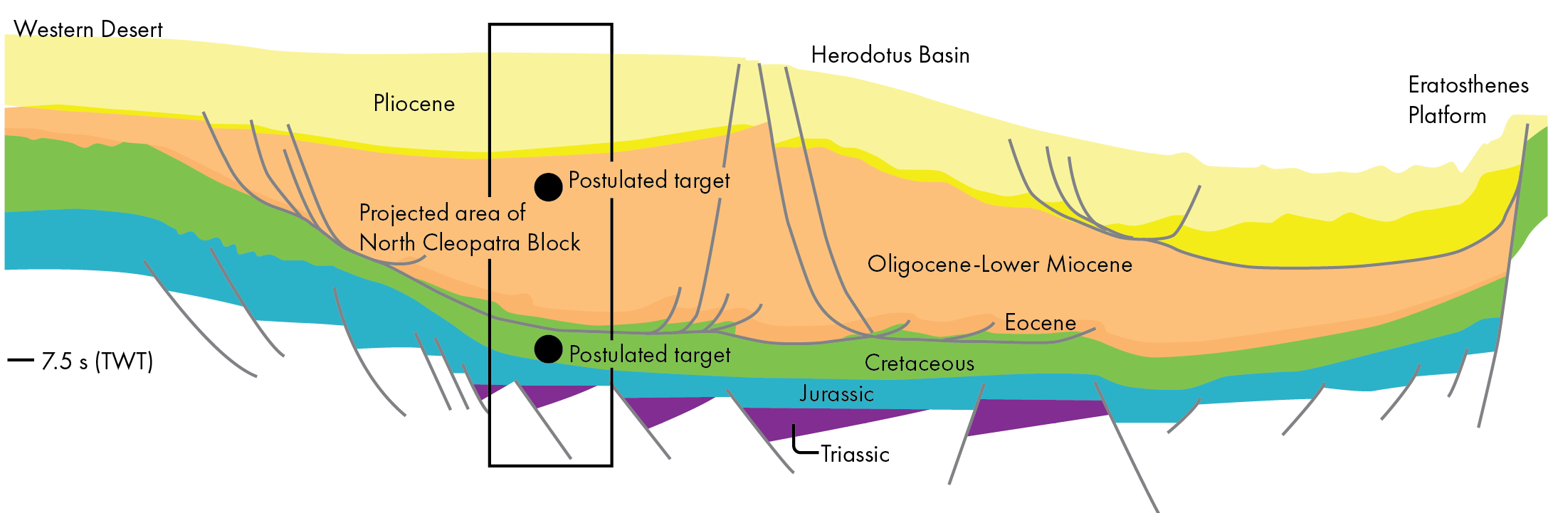
In line with this basin history, the oldest sediments that can be expected in the area where the well was drilled are Triassic to Lower Jurassic sediments, possibly deposited in the hanging walls of tilted fault blocks. These sediments might also constitute the oldest source rock interval, which is likely to be gas-prone at present levels of thermal maturity. Speculative deep exploration targets could include Triassic to Lower Jurassic shallow water carbonates developed on footwall highs.
The rapid subsidence of the Herodotus Basin during the Mesozoic meant that the Middle Jurassic to Cretaceous platform margin shows a back-stepping character, with the North Cleopatra Block clearly in a deepwater setting. Increased sediment delivery from the margin during the Cenozoic, or a slowing down of subsidence rates, must have contributed to a slight progradation of the shelf margin in more recent times.
A prominent feature in the area is the so-called Matruh Canyon, which is likely to have been a sediment corridor into the basin since Late Jurassic or Lowermost Cretaceous times. Any Upper Jurassic or Cretaceous targets of the Velox-1X well could therefore be into deepwater sands shed off the margin via the Matruh Canyon. It is not impossible that some of these deepwater sediments have a high carbonate content, as the main facies around the margin at the time is thought to be a mixed carbonate and siliciclastic system. This is also confirmed by data from some onshore Western Desert fields, particularly those situated close to the present-day coastline.
The second source rock interval that is likely to be present in the area of the North Cleopatra Block is a series of Cretaceous black shales, deposited during worldwide anoxic events.
The Cenozoic, which constitutes a thick succession in the area, is probably mostly sourced from the paleo-Nile, at least during the Oligocene and Middle Miocene when the Levant Basin to the east experienced a predominantly fine-grained sediment input. Rapid deposition might have caused gravity sliding of the succession, possibly facilitating the formation of hydrocarbon traps in what is generally believed to be a prospective interval. The overlying Pliocene succession is thought to be less prospective for oil or gas.
Knowing that the target of Velox-1X was a Lower Cretaceous reservoir, now looking at the regional geological setting, the well probably targeted a series of deepwater sands sourced from Lower Cretaceous anoxic mudstones. Any Oligocene or Lower Miocene secondary targets are likely to be deepwater sands sourced from the Nile when it had a more westerly direction of flow.