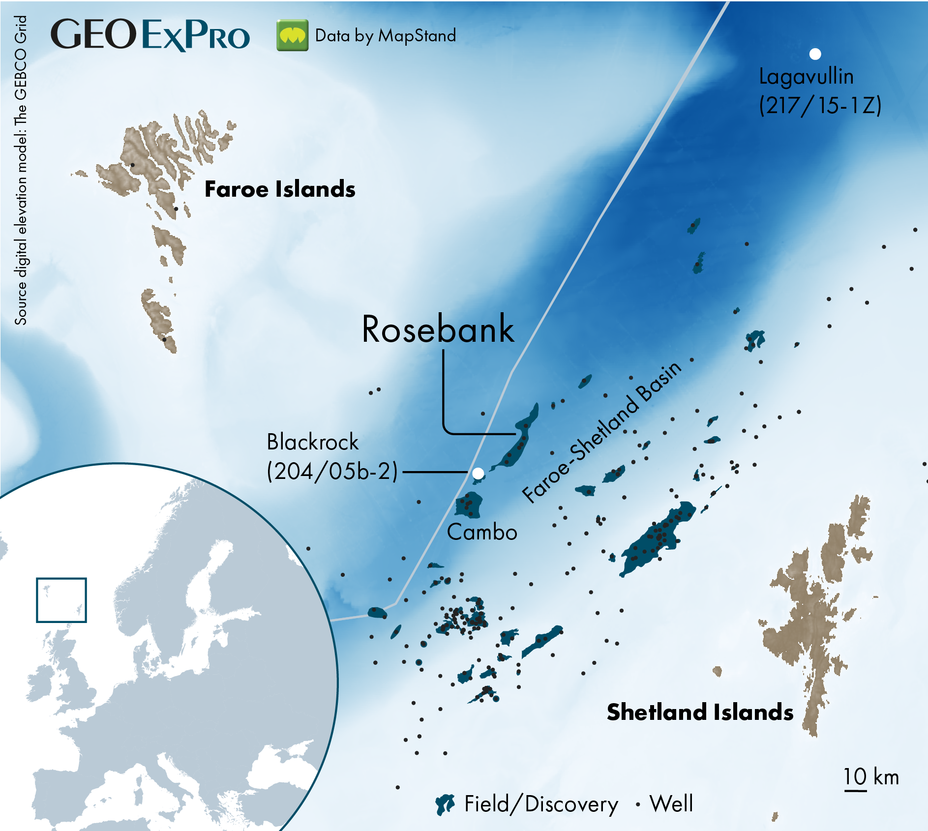
Rosebank was discovered in 2004 by Chevron and partners DONG, OMV and then StatoilHydro. The reservoir quality of the Paleocene/Eocene Colsay Sandstone Member was shown to be good (around 20%), permeabilities great (around 3 Darcy) and an average oil quality of 37° API did not leave too much room for doubt either. Yet, it took almost 20 years, four more appraisal wells and assiocated side-tracks to get more clarity on whether the 300 MMboe accumulation could be developed or not.
It is also quite interesting that it is now Equinor taking the lead on the development with partner Ithaca, whilst it was Statoil in 2012 that decided to divest its share in the Rosebank licence to OMV. It is full circle for Equinor for sure, after gaining operatorship in 2019.
But what is the most important reason behind the time it took to reach this point? The geology
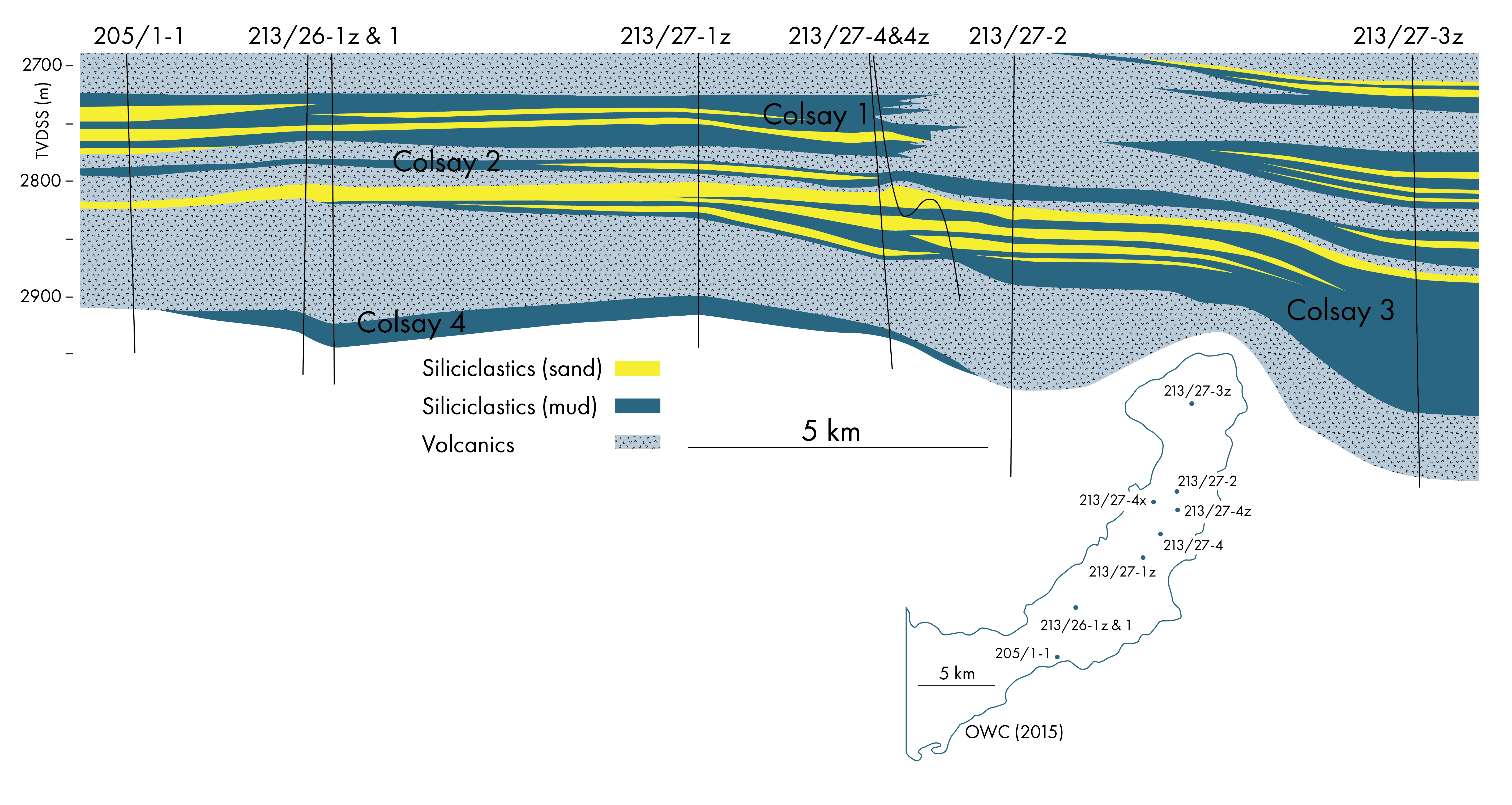
Even though the Rosebank discovery is in good quality reservoir sands, the reservoirs are separated by a series of basaltic lava flows. And it is the seismic imaging problems related to these lava flows that have complicated building an accurate picture of the architecture of the field, which consists of four different reservoir intervals separated by volcanic units. For that reason, teams of geoscientists at Chevron and later at Equinor have been studying the discovery for a long time, trying to better understand and map the connectedness of the fluvial-deltaic reservoirs.
The discovery of Rosebank not only led to many years of research within oil companies; it also sparked many research projects in academia, especially in Aberdeen and Durham, to better study the interaction between siliciclastic and volcanic depositional systems. Up to that point, not much research had been carried out on these settings.
Lateral variation
Partly due to the imaging difficulties, conceptual models were always important to form an understanding of the architecture of the individual sandbodies within the Colsay units. Initially, the deposition model assumed a fluvial-deltaic system coming from the southeast. Looking at the wells on the field, they would in that case have sampled the lateral variation of the sedimentary system quite well. Only at a later stage though, it transpired that the direction of flow was more likely to be from the southwest to the northeast, which is parallel to the positions of most wells. Therefore, if that model is still the most accepted one, it means that the lateral facies distribution on Rosebank has not been sampled very well and a surprise may happen later down the line when the first development wells will be drilled.
Velocities
Velocity variations in the overburden have also been known to be an issue in the area. As was demonstrated at Cambo only a stone’s throw away from Rosebank, two wells that are only 3.5 kilometres apart plotted at significantly different levels in time domain whilst in depth the top of the mapped Hildasay turned out to be at nearly the same level. If the variations in overburden velocities are also present at Rosebank, there may be a knock-on effect on the predicted volumes in the closure as a result.
Role of volcanics
Despite the imaging problems that the Rosebank basalts caused, the presence of the volcanic intervals may also have had a positive influence on the field. In most sedimentary systems where volcanic influence is missing, fluvial systems tend to erode into each other, leading to partial removal of the sedimentary archive. In the Rosebank area, the cycle between southerly-derived siliciclastics and northerly-derived basalts may have resulted in the preservation of a more extensive reservoir section than would have occurred otherwise.
In addition, rather than the detrimental effect most magmatic intrusions have on the reservoir quality of neighbouring sandstones, the effect of a lava flow on porosity and permeability of the underlying sandstones is generally quite small. The heat released from these flows just goes up in the air.
In that sense, given the four cycles of sandstones and volcanics, the Rosebank area is in quite a sweet spot when it comes to hydrocarbon potential. Further north, in the direction of the Faroese sector, the presence of these sands in much more scattered, whilst the thickness of the volcanic succession, which is not always that easy to drill through, is increasing rapidly. It explains why exploration in the Faroese sector has never taken of to the same extent as in the UK part of the Faroe-Shetland Basin.
Seal or no seal?
Then there is the question to what extent the lava flows contribute to the pore space. At the end of the day, the recently drilled Blackrock well nearby found oil in time-equivalent lava flows. In the Lagavullin exploration well, open pore structures in the basalts have been encountered, leading to mud losses. However, the wells drilled on Rosebank did not result in similar losses, which could indicate that in this case the volcanics are more likely to be tight and form a seal rather than a reservoir. It could also better explain the different fluid contacts across the field.
In conclusion, based on the geological uncertainties briefly discussed above, it is understandable why it took so long for Rosebank to get to FID. The first drilling results will therefore be critical and may lead to an upward or downward revision of expected volumes, but that is something that is not too uncommon for projects of this kind anyway.