The Republic of Suriname, with its capital city Paramaribo, is located just north of the Amazon delta on the north-east coast of South America. Since 1980, the petroleum industry has made great progress and has gained a prominent place in the economy of the country. The national oil company, Staatsolie Maatschappij Suriname, is involved in the entire spectrum of petroleum activities: from exploration to refining and marketing. It acts as the petroleum regulator and is responsible for promoting open offshore acreage, negotiating petroleum agreements and monitoring the contracts signed with IOCs. It also manages the data and allows interested companies access to a large open file data set.
The Cretaceous-Tertiary Guyana- Suriname Basin is a classic passive margin basin which came into existence when Africa separated from South America. Prior to this event the area was part of the basin that formed when North America drifted away from North Africa. During this earlier period a thick sequence of Jurassic to Early Cretaceous sediments was deposited. Consequently a thick succession of Jurassic to recent sedimentary section has been built up in environments of deposition ranging from near coastal to deep-marine. Locally carbonates are also found in the basin.
The Suriname part of the Petroleum Province measures 153,000 km2 and is divided into the onshore, seven near shore blocks and over 20 offshore blocks, with water depths ranging from 50m, about 50 km from the coast, to over 3,000m in the extreme north-west corner of Suriname’s territorial waters.
Staatsolie is the sole operator of the onshore blocks with the exception of the Coronie and the Uitkijk blocks, which are operated by its subsidiary Paradise Oil. Operators in the offshore include Apache, Tullow, Teikoku, Murphy Oil, Kosmos and Petronas.
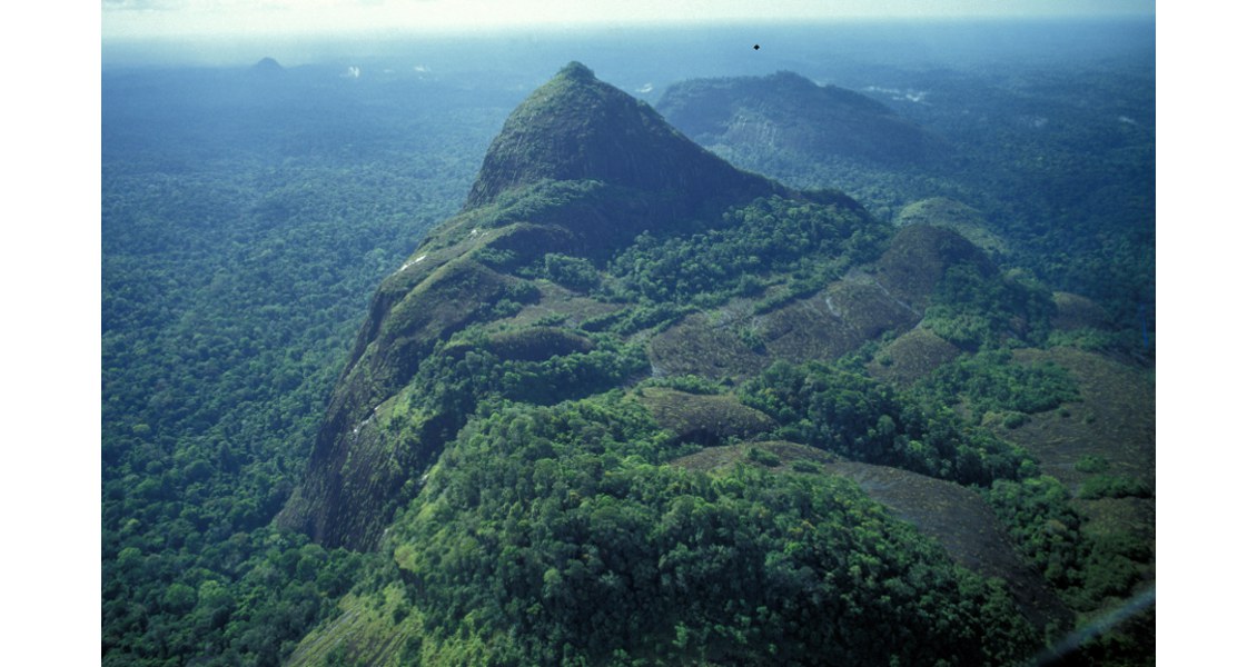
Roseveld Peak is a 784m granite mountain with breathtaking views over the tropical rainforest. (Source: Staatsolie)
Mixed Exploration Success
Oil was first discovered in Suriname in 1928 in the District of Nickerie on the coastal plain close to the border with Guyana, but systematic exploration both onshore and offshore only started in the early sixties, when a number of IOCs became interested. In 1965, during a potable water drilling campaign by the Geological Mining Department, oil was discovered in the coastal District of Saramacca – in a school yard.
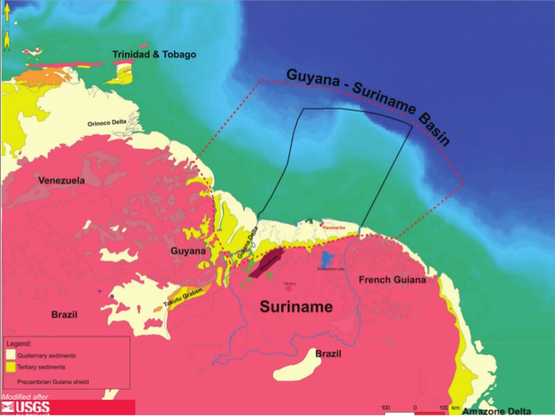 Outline of the Guyana- Suriname Basin. The north-pointing Demerara rise can be traced back to the Guinea Conakry coast, across the Atlantic in West Africa. (Source: After USGS)In 1980 Staatsolie was established and the first commercially produced oil came to surface in 1982 from the onshore Tambaredjo Field, near Paramaribo. Crude is produced from Paleocene sands from a depth varying from 260 to 425m and the STOIIP of this field is 700 MMbo. Since 1982, 100 MMb of Saramacca Crude, a heavy sweet oil (16° API) but low on vanadium and sulfur, have been produced. Remaining reserves are estimated at approximately 80 MMbo.
In addition, the nearby Calcutta and the Tambaredjo North West Fields have been on stream since 2003 and 2009 respectively. They are producing from Eocene and Miocene stratigraphic traps, and the total present day production is 16,000 bopd.
Exploration activities in the offshore were less successful. Between 1957 and 1980 four exploration wells were drilled offshore by Colmar and in 1980 the first PSC was signed with Gulf Oil. These efforts did not lead to commercial discoveries nor did the efforts of the Energy World Trade group in 1986. New hope came with the studies executed by Pecten in 1993. Under a PSC signed in 1999 with the Suriname Deep Water Consortium, consisting of Burlington, Shell, TotalFina and Korea National Oil Company, the first regional 2D survey was acquired. However, no wells were drilled.
A study by the USGS (2000) identified the Suriname-Guyana Basin as an under-explored basin with a potential recoverable exploration resource of 15 Bbo, based on the petroleum system associated with the Late Cretaceous- Tertiary Basin. This estimate caught the attention of the industry and triggered Staatsolie to make acreage available through competitive bid rounds. Since 2004 PSCs have been signed with a number of IOCs recognized for their success in frontier exploration. In the last ten years a vast amount of 2D and 3D seismic data was acquired, as well as gravity and magnetic data.
Between 2007 and 2011, four exploration wells were drilled. Repsol’s West Tapir well and Murphy’s two wildcats did not encounter what they were hoping for, while Teikoku Oil, who drilled the Aitkanti well in Block 31 about 100 km north of Paramaribo, believed that the purpose of the well was accomplished.
As of July 2013, a total of 65,000 km of 2D seismic has been acquired over the whole basin. In order to de-risk the prospects, approximately 17,000 km2 3D data, mostly offshore Suriname, has been acquired.
Conjugate Margins
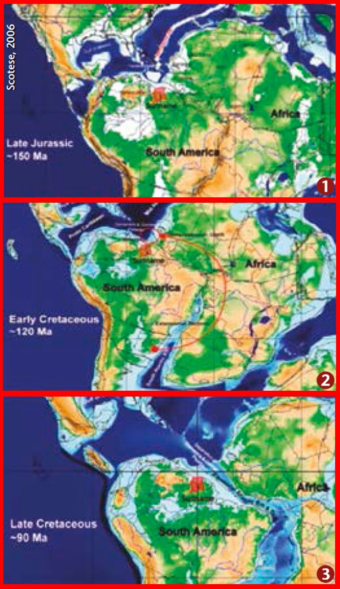 Palaeogeographic reconstructions. 1: Rifting of South Atlantic region; 2: Counter-clockwise rotation of Africa; 3: Drifting of South AmericaThe petroleum geological history of Suriname begins in the Late Jurassic when the North Atlantic rift system, separating North America from North Africa, progressed southward to the Central Atlantic region. The southernmost tip of this rift system terminates in the Takutu Graben, onshore Guyana, where Jurassic lacustrine source rocks resulted in an as yet non-economic light oil accumulation.The stratigraphy of the Jurassic rift basins is poorly known in Suriname, since no well penetrations are available. However, from the Takutu Graben and the conjugate Atlantic margin in Africa, a first estimate of the basin fill can be made. Lacustrine source rocks, alluvial fans and fluviatile deposits, together with volcanoclastics, make up the lower stratigraphy, while salts point to local restricted basins. The salts are overlain by marine clastics and carbonates.
The opening of the South Atlantic Ocean created a counter-clockwise rotation of Africa, causing compression, with inversion of the Jurassic grabens. The uplift and erosion of the Jurassic grabens are clearly seen on seismic over the Demerara Plateau offshore Suriname. This was followed by the rift and drift phase of the South American and African plates and subsequent formation of the present passive margin basin.
A major break-up unconformity occurred, marking the onset of deeper marine deposition in response to the still continuing thermal subsidence after the break-up. This break in the stratigraphy is evident throughout the basin. During this period the prolific Cenomanian-Turonian source rock was deposited offshore along the deeper marine margins of South America and West Africa.
According to Stolte and Darden (2013), the petroleum system of the Guyana-Suriname Basin is believed to be a conjugate of the petroleum system present in West Africa that has revealed several huge discoveries, such as the Jubilee discovery in the Tano Basin offshore Ghana.
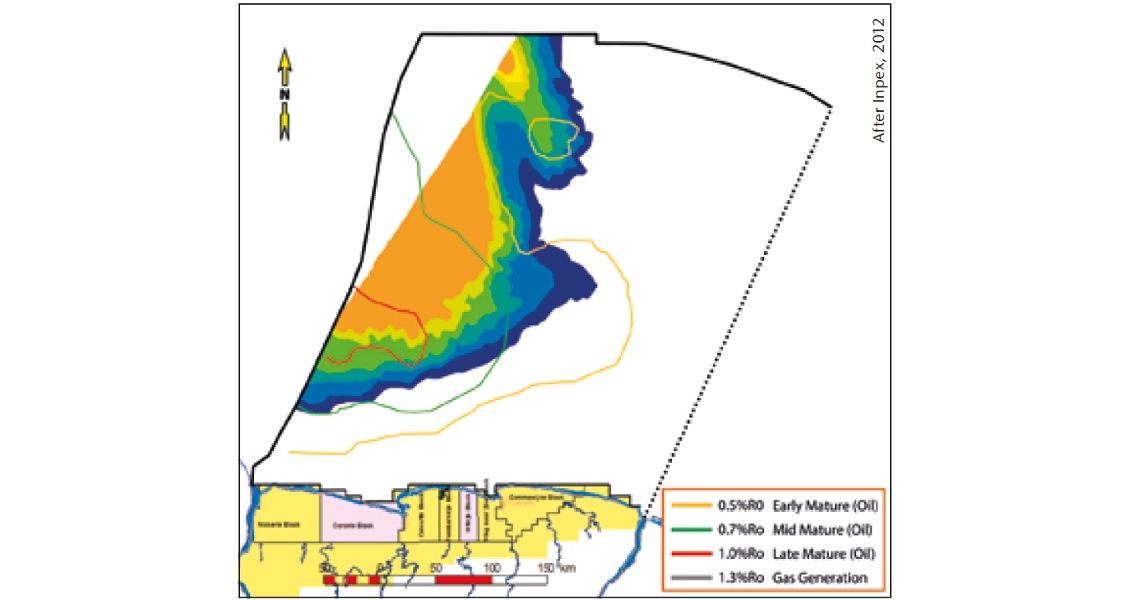
Distribution of the Cenomanian-Turonian source rock.
Good Source Rocks
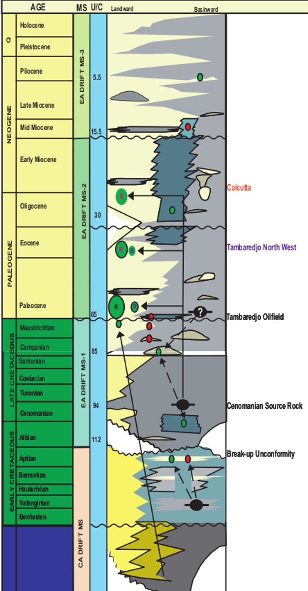 Stratigraphy. Source rock link to reservoir samples confirmed by analysis. Facies change landward (S) to basinward (N) and range from coastal through shallow to deeper marine.The stratigraphy reflects the tectonic influences since the Jurassic age. About 2,000 onshore and 26 offshore wells provide a solid data set to evaluate the stratigraphy of Suriname.
In Suriname the proven source rock is the Cenomanian–Turonian organic shale. Oil generated from this source rock migrated for approximately 150 km to be trapped onshore in sand reservoirs of the Tambaredjo, Tambaredjo NW and the Calcutta fields. The trapping is stratigraphic (pinch-outs) and the reservoirs are sealed by interlocking high-stand shales. The Cenomanian-Turonian source rock is the time equivalent of the well known La Luna Formation in Venezuela and the Naparima Hill Formation in Trinidad.
Typing of heavy oil shows from onshore wells east of the Tambaredjo field indicates the presence of an additional source of possibly Jurassic age. Lacustrine source rocks occur on both margins of the Central Atlantic (for example Angola and Brazil). Early Cretaceous source intervals have been encountered in some offshore wells, with TOC ranging from 0.7 to 7.5 %.
Similar source rocks and associated oil seeps and slicks have been encountered in the conjugate setting of Guinea Bissau and Guinea Conakry.
Various Play Types
In 2010, hydrocarbons were produced from Tullow Oil’s Zaedyus discovery offshore French Guiana, pointing to trapping in Late Cretaceous turbidites charged by the Turonian-Cenomanian source rock. The Zaedyus well hit 72m of net pay in three sands in two turbidite fans offshore French Guiana.
Angus McCoss, Tullow’s Exploration Director, commented in September 2011: “The discovery at Zaedyus has proved the extension of the Jubilee play across the Atlantic and made an important new discovery in French Guiana. Tullow has built a commanding and unique acreage position in South America and this result marks the start of a significant and potentially transformational long-term exploration and appraisal campaign in the region.”
Various play types have been identified offshore Suriname. In the Jurassic syn-rift setting these include anticlines, fault traps, possible salt traps, sub-crop traps and stratigraphic pinch-outs. The strongly-dipping Late Jurassic sequence depends on closure against syn-rift unconformities. Indications for the prospectivity of this play type are not only from the lacustrine oil discovered in Suriname, but also from the Jurassic to Lower Cretaceous sourced petroleum systems in West African basins and Brazil.
Potential plays in the Cretaceous and Tertiary post-rift cycles include carbonate platforms, channel complexes, anticlines, fault traps, turbidites, pinch-outs, and shelf edge canyon sand basin floor fans.
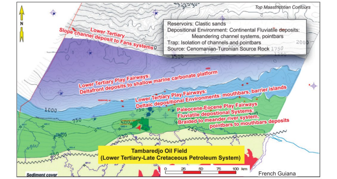
Tambaredjo-Calcutta Field analogs. The various environmental belts are plotted on a Base Tertiary/Top Cretaceous contour map. The onlap of the Cretaceous is highlighted by the wavy line. Tambaredjo-Calcutta Field analogs can also be expected in the eastern part offshore area on the continental shelf. Down dip deltaic canyons as well as turbidite systems can be expected. The Paleocene-Eocene fairway is characterized by coastal marine/tidal settings.
Potential to be Explored
The coming years will be very critical for the further confirmation of the hydrocarbon potential of the Suriname-Guyana basin. Its success will depend on refinement of the prospect portfolio through detailed studies of the existing data set and through further acquisition of high-tech 3D seismic that can better image, for example, the stratigraphic plays.
If the potential is validated, the region will have to manage the rush of IOCs that will want a piece of the action. For the time being the focus is on the exploration wells that will be drilled by the current operators between 2014 and 2016.
Further Reading on Petroleum Activity in Suriname
Some recommended GEO ExPro reading relating to oil and gas exploration activity in Suriname.
Suriname – New Technology Unlocks Hydrocarbon Potential
Clyde Griffith, Ralph Kariodimedjo and Mohamed Chandoe, (Staatsolie) Christian Richards, Paul Versnel and Ben Spurgeon, (AustinBridgeporth)
An improved knowledge of fault systems is important in understanding Suriname’s onshore oil fields – and the application of FTG data can be a vital tool in unlocking this knowledge.
This article appeared in Vol. 13, No. 4 – 2016


