
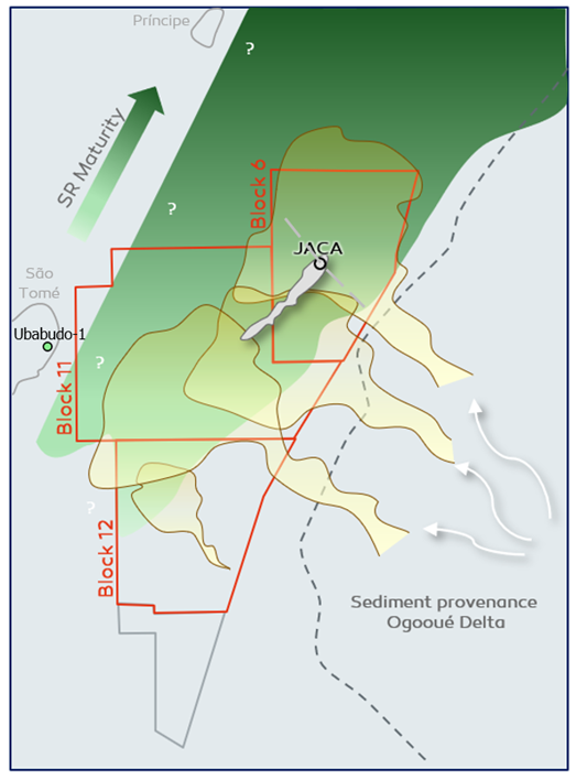
Location map of Galp exploration blocks in São Tomé & Príncipe - zoom in of Figure 1.
A working petroleum system on purely oceanic crust
Drilling Jaca-1 in the Deep-Water Gulf of Guinea off eastern São Tomé and Príncipe Islands
*Christian Niño currently works at Petronas and Martin Zubiri works at Pan American Energy.
For a long time, exploring for hydrocarbons in the deep waters of the Gulf of Guinea, east of the São Tomé and Príncipe (STP) islands, was not regarded as very attractive by the industry. The main reasons were the uncertainty regarding the presence of source rocks and the premise that this whole area was on oceanic crust and, therefore, under a cold thermal regime. This, coupled with the limited overburden, would make it difficult to mature any source rock. Not to mention the water depths being more than 2,200 m, with the associated logistical and operational challenges.
Galp is present in 3 exploration blocks in STP, being the operator in blocks 6 and 12, and partner in block 11 (Figure 1). Galp signed the PSC for Block 6 in November 2015 and is currently beginning the third phase of the initial three phases of the exploration term.
During the first exploration phase, Galp and Kosmos Energy acquired a large 3D broadband seismic of approximately 16,000 km2 in a former partnership over Block 5, 6, 11 and 12, together with gravity, magnetic and bathymetry data. During this phase, oil samples from seeps were taken on the islands of São Tomé (Ubabudo) and Príncipe (Agua Clara).
The planning and drilling of the Jaca-1 well were the main activities during the second exploration phase. The primary objective of the well was to test a NW-SE elongated 4-way to 3-way dip closure of Turonian age. The well also had two secondary stratigraphic objectives of Campanian age. Another objective of the well was to drill the postulated Turonian and Cenomanian source rocks.

A pleasant surprise
The well was spudded in water depths of approximately 2,550 m and safely drilled under a Technical Service Agreement with partner Shell in remote operating conditions to a total depth of 5,658 m MD.
The thermal regime observed at the well was slightly higher than the pre-drill estimation, which was a pleasant surprise. This is particularly noteworthy as no wells had been drilled in a purely oceanic crustal domain setting in this part of the Gulf of Guinea before.
Jaca-1 drilled a thick Upper Cretaceous sandy section of more than 700 m, with approximately 500 m of high-quality reservoir sands (Figure 2). MDT data confirmed the presence of four thin hydrocarbon-bearing zones whilst several fluid samples were collected (oil and water).
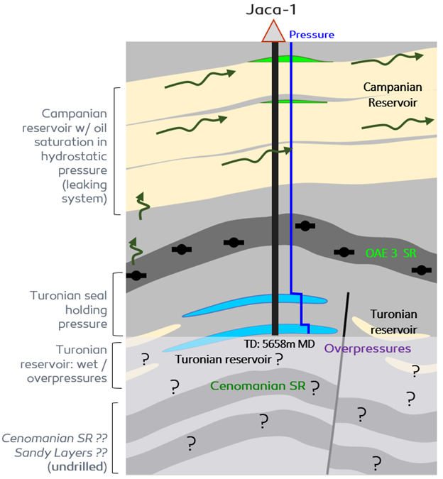
The oil samples indicated light oil, with GOR’s around 1,000 scf/bbl and no signs of biodegradation. Geochemical analyses suggest that they were generated by an Upper Cretaceous marine siliciclastic source rock, probably the same source rock facies that generated the oil at the Ubabudo oil seep in the São Tomé Island.
Jaca-1 also drilled an Upper Cretaceous marine source rock. It corresponds to OAE 3 and, although immature at the well location, it has been correlated to the oils recovered from the Jaca-1 reservoir sands higher up. Petroleum systems modeling suggests that the kitchen is located towards the Campo and Kriby fracture zones in the northwest. Regional hydrocarbon migration is to the southeast, so the oil found in Jaca-1 has therefore proven mid to long lateral migration in addition to vertical migration up into the Campanian.
A working petroleum system
Unfortunately, the well did not find a blocky reservoir at the main target in the Turonian, but encountered thinly bedded sands instead. Even though good porosities were observed in these sands, permeabilities turned out to be at the lower end of the spectrum and were water-wet. The well was therefore TD’d before drilling the postulated mid-Cenomanian source rock.
In summary, Jaca-1 proved the presence of a working petroleum system in the deep-water setting of the Gulf of Guinea, with the kitchen being located mostly on oceanic crust. Excellent Upper Cretaceous reservoir sands were also confirmed, with light oil being able to migrate both laterally from the source kitchen to the northwest as well as upwards to reach the Campanian reservoirs.
This article can also be found in Issue 1 of the GEO EXPRO magazine, which can be downloaded here.