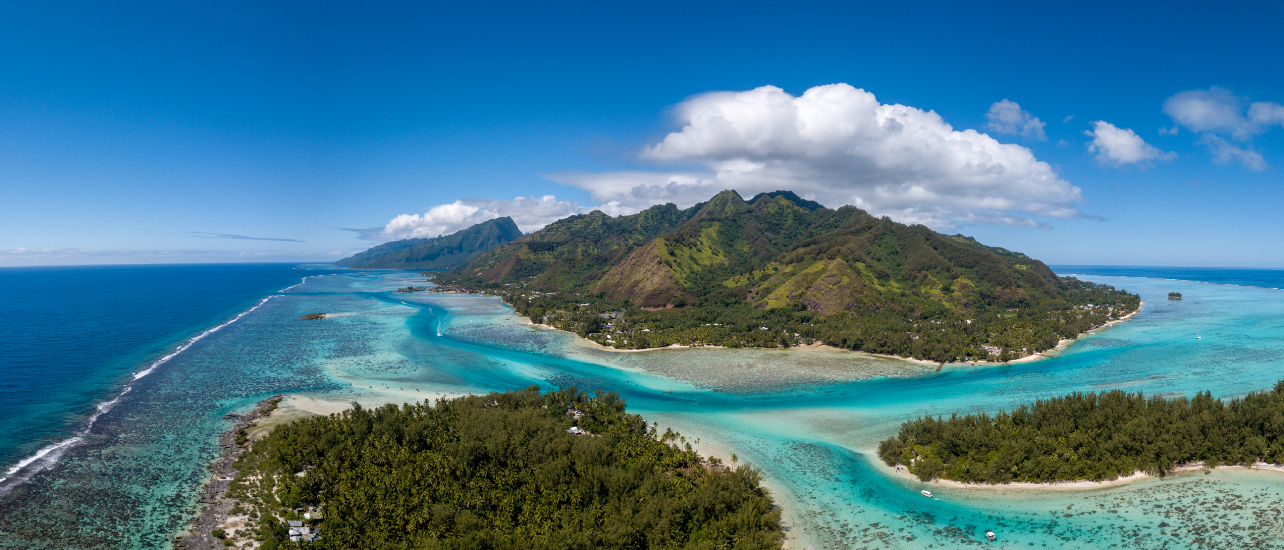
Finding deep sea minerals with oil and gas technology
The sulphide deposits on the Norwegian continental shelf can form the basis of a new industry. Well-known Norwegian exploration technology can help us map them.
“With conventional exploration for oil and gas, electromagnetic measurements (EM) are used to map resistivity in prospects – hydrocarbons are more resistive than brines. When we are looking for minerals, the opposite is true. It is comparable to using a metal detector to look for coins on the beach”, explains Dag Helland-Hansen, EVP Global Sales and Exploration Advisor at EMGS.
EMGS is among the companies that have positioned themselves for a possible new industry on the Norwegian continental shelf. In the deep sea on the Norwegian shelf, the “coins on the beach” are represented by metal-rich massive sulphide deposits (seafloor massive sulfides, SMS).

Seismic and EM – An elegant solution
Traditional geophysical exploration methods such as EM can play an important role in finding the hidden sulphide deposits. However, electromagnetic measurements are not the only exploration method suitable for marine mineral mapping.
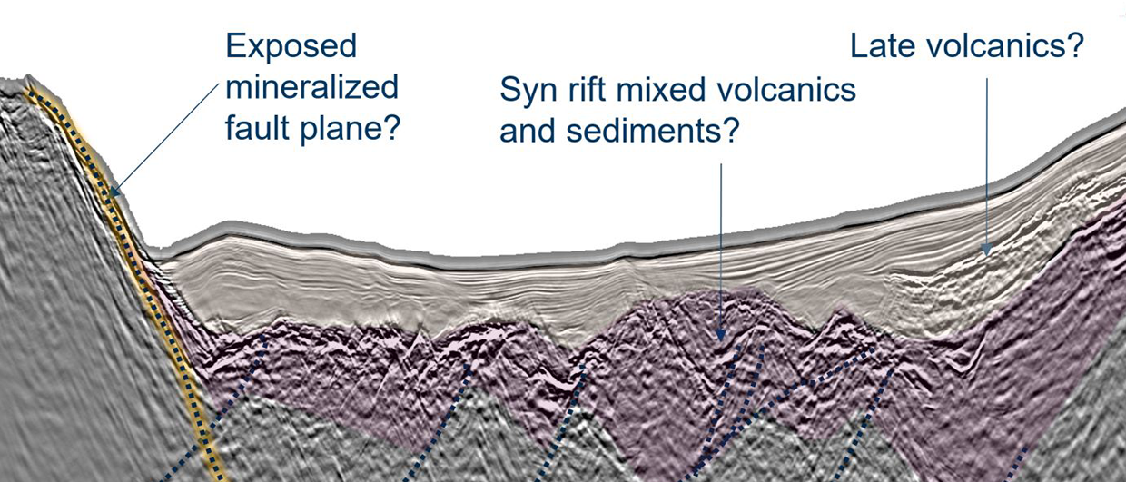
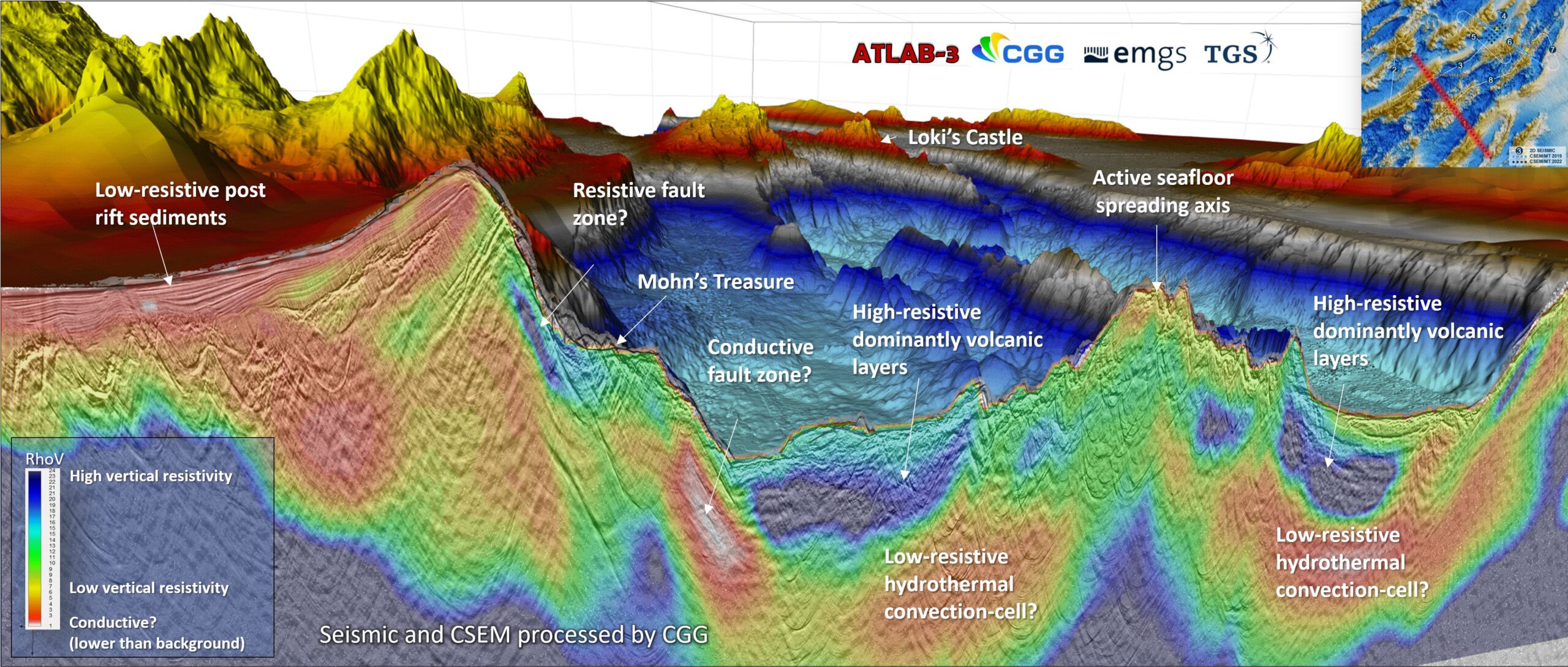
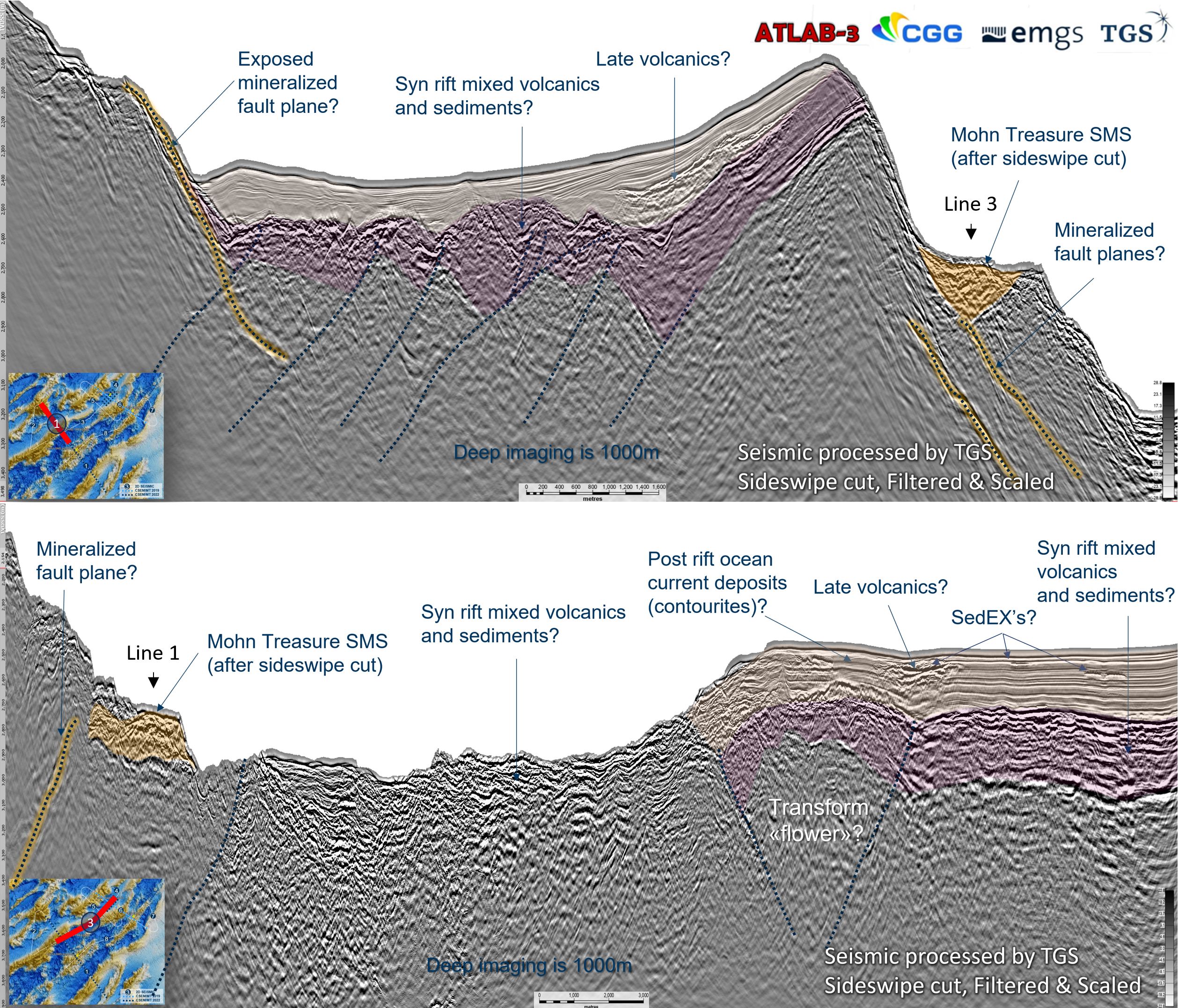
“Seismic data is crucial for getting a picture of the structures and layers on and below the seabed. With a geological understanding of how and where the sulphides occur in the back of your mind, the seismic can tell us which geological bodies stand out as possible targets”, says Bent Kjølhamar, senior geologist at TGS.
Kjølhamar adds that seismic data can also provide a clue as to what kind of rock a given geometric body identified in seismic data consists of. “Published data show that sulphide deposits often have somewhat higher seismic velocity and they will typically have a higher density than the surrounding sedimentary or volcanic layers. This will normally give a good contrast and a strong seismic reflection.”
However, he admits that there are also other structures at the mid-ocean ridges that have similar signatures, namely fresh volcanic rocks, be it solidified lava or intrusions.
“But this is where EM comes to the rescue. It can distinguish mineral deposits from volcanics because the former are far more conductive than the latter. The combination of seismic and EM is therefore an elegant solution for identifying sulphides”, the senior geologist explains.
Helland-Hansen adds: “An EM signal in itself is not sufficient. It is low frequency and cannot provide a precise position of a possible conductive body. But if we put the EM data on top of the seismic data, we can map the geological bodies and determine which of them are conductive. We have then narrowed them down to interesting targets for the exploration companies.”
Deep Imaging Consortium
It is obvious to Kjølhamar and Helland-Hansen that service companies such as TGS and EMGS should join forces and deliver joint geophysical solutions regarding the search for sulphide deposits.
Not only have they both worked for several years to understand how the technologies of their companies can be applied to finding deep sea minerals. They have also had the opportunity to test the technologies on the Norwegian continental shelf through the NTNU-led consortium ATLAB, which most recently carried out a cruise along the Mohn Ridge in 2022.
ATLAB started as a pure research project to achieve a new understanding of the formation of the Atlantic Ocean. However, it gradually became clear that the research was very relevant to understanding the hydrothermal systems under the seabed and therefore also the formation of the mineral deposits in this unique environment.
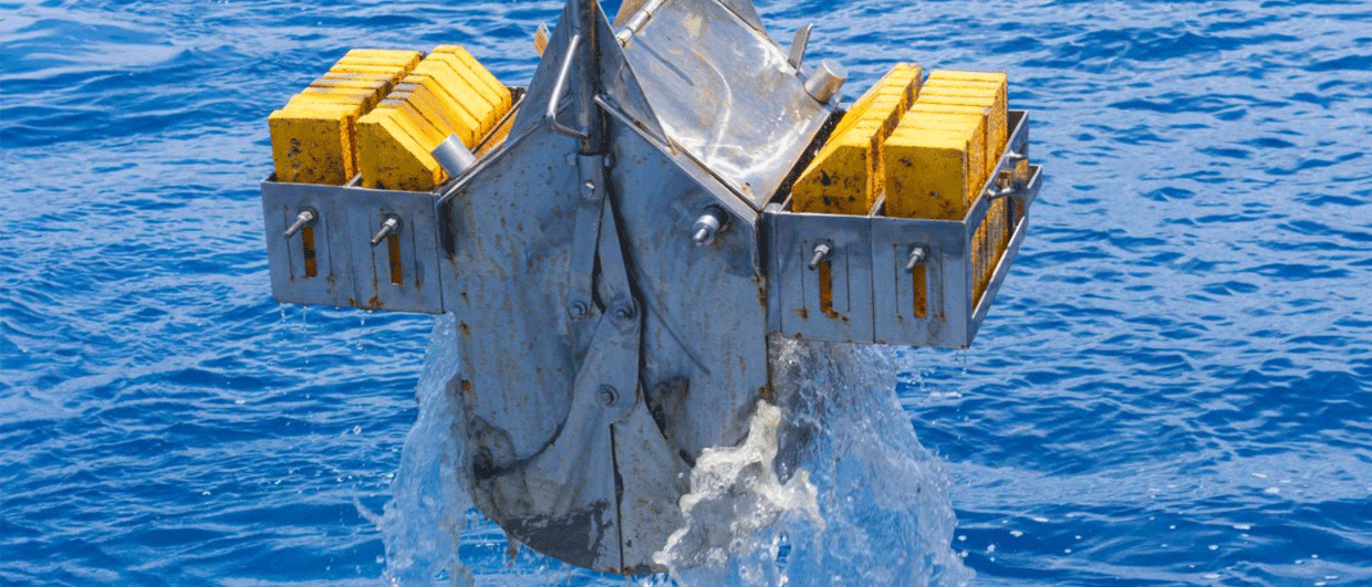
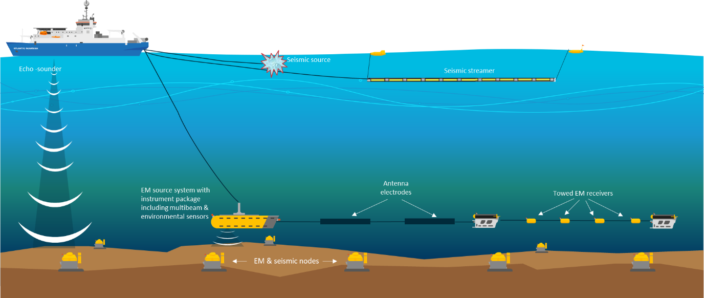
Both Helland-Hansen and Kjølhamar were instrumental in expanding the consortium’s focus towards applied research on deep-sea minerals. With that, more industrial companies joined the consortium as well. During the 2022 cruise, EMGS learned that conventional acquisition with nodes on the ocean floor and a source towed deep, near the ocean floor, is most cost-effective for good EM imaging.
Hilly terrain presents challenges
The hydrocarbon-prospective areas on the Norwegian continental shelf are usually located where the seabed is relatively flat. In contrast, the landscapes at the mid-ocean ridge are more reminiscent of the western and northern Norwegian mountain areas. In the “valleys” we find sediments deposited by ocean currents. These can be 300 meters thick. In steep terrain and on the peaks, where the ocean floor crust is usually exposed, they are usually absent.
The EM source should be towed as close to the seabed as possible so that the signals are not absorbed in the water column. At the same time, the operator must avoid colliding with a rock face.
Despite this, Helland-Hansen is satisfied with the data they have collected so far, and has plans for how to tow the source more slowly and closer to the seabed in all kinds of terrain during future collections.
Kjølhamar adds that it is difficult to avoid this type of topography if sulphides are to be found. “At the end of the day”, he says, “the prospects tend to be located along steep slopes, mainly on the side of or above deep fault planes that can be seen on seismic.” The explanation lies in the fact that the faults often form conduits for deeply circulating mineral-rich water to reach the seabed.
Sulphides also occur as axial deposits, i.e. on volcanic ridges in the centre of the axial valleys. The Norwegian Offshore Directorate wrote in the 2023 resource assessment that the frequency of flank deposits is significantly higher than for axial deposits. They also regard flank deposits as superior in terms of tonnage and weight.
Also regarding seismic acquisition, hilly and steep terrain can present challenges. Kjølhamar firmly believes that 3D collection is necessary to obtain sufficiently good data. During the ATLAB-3 cruise, however, only 2D seismic data was collected.
Smaller climate footprint
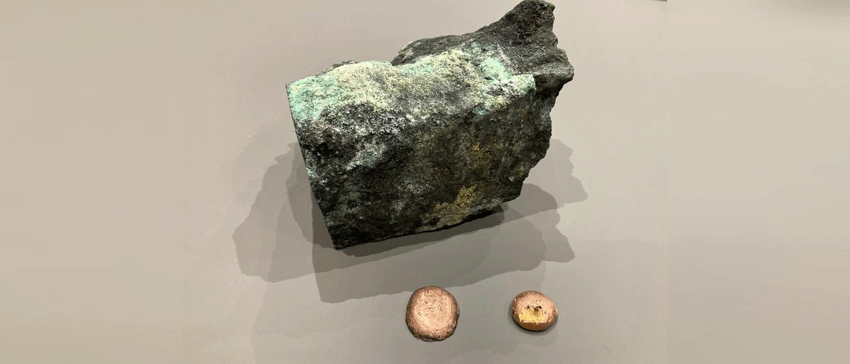
Kjølhamar points out that the high concentrations of sulphides such as copper, zinc, silver and gold can not only contribute to better project economics, but also facilitate a smaller climatic footprint.
Higher grades mean that less material needs to be extracted, transported and processed per produced kg of metal.
Copper mines onshore currently operate deposits with an average grade of around 0.6%. In addition, about twice as much overburden must be removed before the ore can be extracted. This means that around 500 kg of rock and ore are extracted for every kg of copper produced by mining on land. Kjølhamar believes it should be possible to extract sulphide ores in the deep sea with grades of around 5% copper without significant overburden, which can reduce the amount of tailings by 90 – 95 percent.
“When we collect 2D seismic in hilly terrain, we get a problem with so-called side sweep. This is not a problem with 3D seismic. Another disadvantage of 2D measurements is of course that they only cover a narrow field along the acquisition line. As sulphide deposits are far smaller – on the order of 0.1 – 1 km2 – than most hydrocarbon accumulations of commercial interest, it is easier to miss them.”
“It can be solved to some extent by running many parallel 2D lines, or dense 2D grids, but then it will quickly justify acquiring 3D seismic to be sure that all present deposits are mapped within a given area”, notes the senior geologist.
Helland-Hansen points out that 3D collection also provides a better product for EM data. “In short”, he says, “3D EM provides better precision in spatial dimensions. This was also tested and confirmed during the cruise in 2022 with a mini-3D collection.”
One of the data sets to be collected during ATLAB’s 2022 cruise was seismic with nodes on the seabed. Dropping and retrieving the nodes from a depth of 3,000 meters was successful, but the data was incomplete. Temperatures turned out to be the biggest challenge.
“The nodes were simply not set for temperatures below 0 °C. Only one of the nodes collected data, as the temperature around it was just above zero. However, this is not a big problem, as long as we are aware that such cold water masses can be present in the deep sea and adjust the nodes accordingly”, says Helland-Hansen.
Possible to distinguish between metals
As mentioned, the EM technology is based on measuring electric current in the underground. We know very well that metals are excellent when it comes to conducting electricity – but can the EM signal tell anything about what kind of metals are found in a deposit, and at which concentrations?
“As of today, this is not information we have tried to get out of EM data sets. But theoretically, it should certainly be possible, and this will be the next step for us in technology development”, says Helland-Hansen.
“EMGS has experience in determining rock properties in the oil and gas business. Part of a future solution that provides information on the content of sulphide deposits could be the use of IP.”
The EMGS director talks about Induced Polarization, a geophysical method that is related to EM and is used, among other things, by the mining industry on land to find ores.
Briefly, the method works by sending electrical signals underground, followed by measuring the response that comes back to the receivers. Sulphides can preserve an electric field for a short time after the electric signal is sent, and this effect, induced polarization, can be measured and used to distinguish, for example, copper from iron.
The latter metal is of no value to the exploration companies, and so IP can, for example, be used to identify the “bad” prospects.
The ATLAB Consortium is planning another cruise this year, during which the various exploration techniques can be tested further. In combination with the recent government approval for commercial exploration, it can be expected that more activity and innovation will take place in this space. Using technology from the oil and gas business.