Energy companies have invested heavily in data over the past several decades. Seismic surveys, wells, petrophysical data, cores, cuttings, lab data, interpretations, and reports now exist in volumes that were unimaginable only a generation ago.
Yet despite this abundance of data, most decisions that are based on data leverage only a small fraction of the data that has been acquired, and that could be of relevance for the decisions at hand. Why is this the case, and does it need to stay this way?
The problem is not a lack of data, nor a lack of technical expertise. It is a lack of time and efficient tools that can enable large-scale integrated digital workflows. Traditional subsurface workflows are labour-intensive, highly manual and therefore time-consuming. Traditional software solutions are not designed to handle and integrate large, multi-disciplinary datasets. Energy companies, therefore, struggle to scale their data utilization so that more valuable insights can be extracted from existing datasets within the short timeframes that project execution requires. Data may be accessible through many domain-specific platforms and software packages, but access alone does not translate into insight. When core, well-logs, seismic, and other geological information remain siloed across databases, formats, software tools, and teams, the full value of the subsurface is never fully realized.
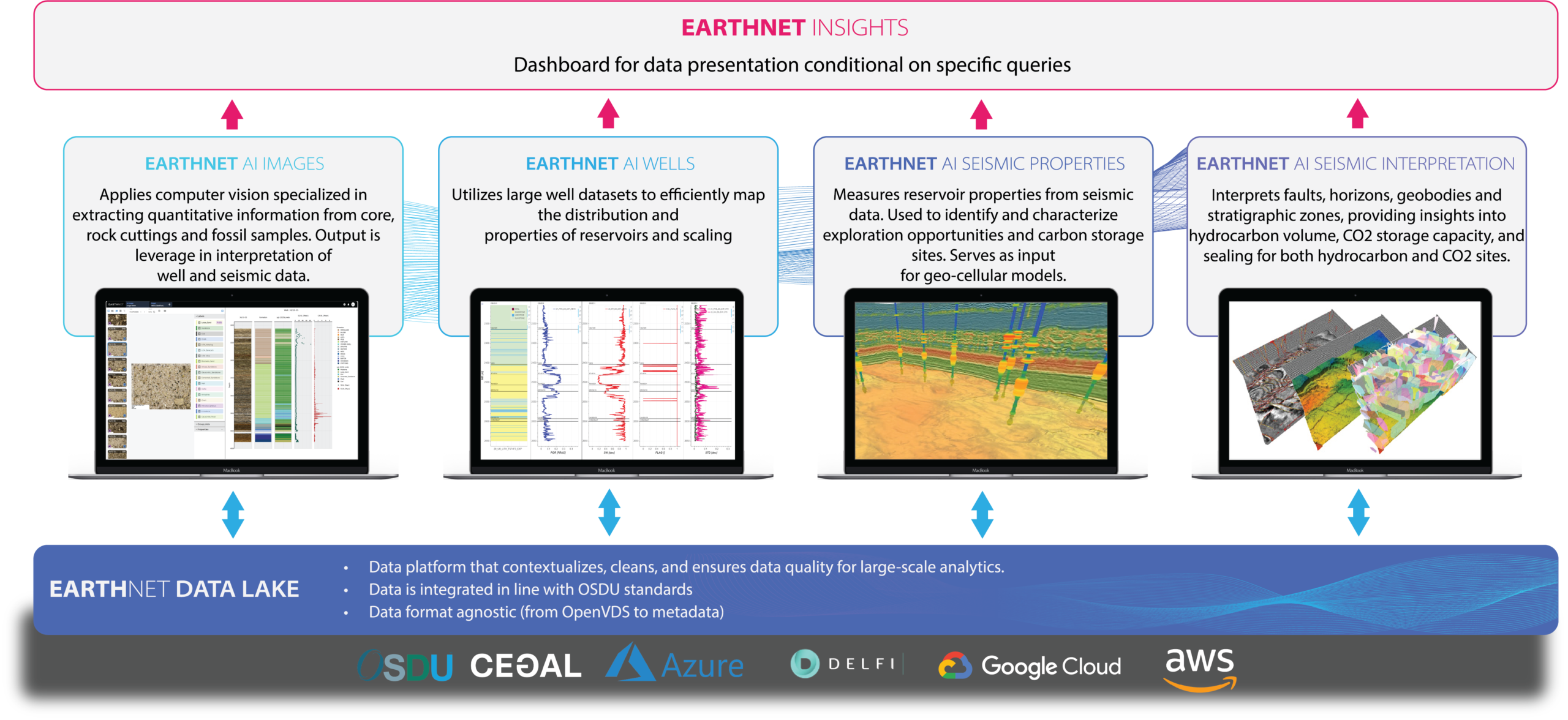
Over the past decade, digital subsurface workflows have begun to change this picture. Advances in data platforms, cloud infrastructure, and AI-enabled analytics now make it possible to connect subsurface data end to end – from ingestion and contextualisation (Figure 2), through interpretation and screening (Figure 2), to decision-making. This raises a critical question for organisations today: If digital subsurface workflows are becoming more widely available, is there still a first-mover advantage – and where does it come from?
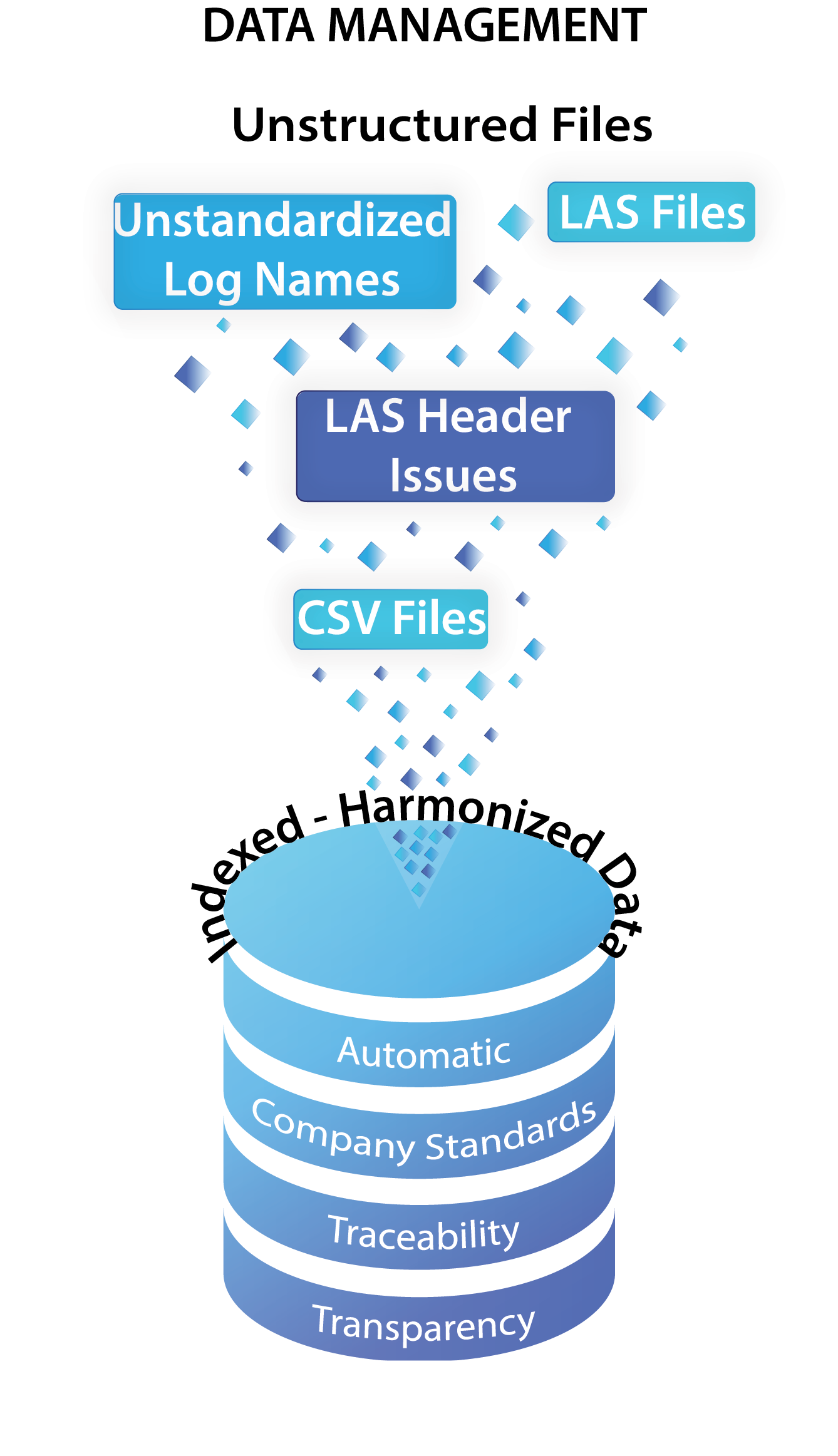
Using EarthNET and its Data Lake module, you can have all the data at your fingertips. Although the data available to subsurface teams is typically siloed and stored within multiple disparate databases, EartNET enables direct access to these data without duplication. The data can be visualized directly from where it is stored. The data can be accessed from legacy corporate datastores, file systems, as well as from OSDU™. Adopting OSDU™ standards brings obvious benefits when it comes to data discovery and data management, since OSDU™ is connecting rich metadata to the data. However, there are several reasons why we need to go beyond just data discovery and management. Modern large-scale integrated workflows require that we have access to harmonized, indexed and contextualized data. EarthNET facilitates the data ingestion and standardization that is required. Raw well data can be ingested at scale from disperate silioed legacy storages, harmonized, and validated to ensure consistency across thousands of wells. EarthNET also facilitates cleaning, indexing, and contextualization of the data making it analytics-ready so that it can feed into multi-disciplinary and highly automated workflows.
From data access to workflow execution
Modern exploration and production strategies increasingly rely on layered digital architectures. Enterprise data platforms – often implemented using OSDU™ standards – provide governance, accessibility, and interoperability. However, these platforms alone do not deliver geological understanding on their own.
Value is created in the layers on top of the data platforms, where data are contextualised, analysed, and interpreted. EarthNET Data Lake operates within this ecosystem by providing structured ingestion, indexing, and contextualisation of seismic, wells, core data, cuttings data, microscopy imagery and interpretations, creating a consistent foundation for downstream analytics.
Building on this foundation, EarthNET functions as the analytics and interpretation layer of the digital subsurface workflow, operating alongside enterprise platforms and enhancing them rather than replacing them (Figure 1).
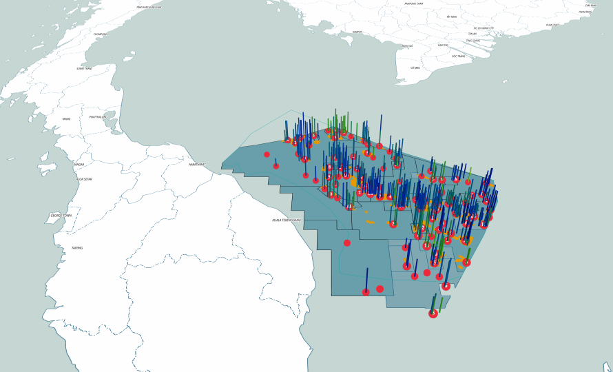
EarthNET is being used by PETRONAS (MPM) as part of their myPROdata platform to give energy companies access to Malaysia’s exploration and production (E&P) data. The purpose is to highlight exploration opportunities in the Malay Basin, as well as to enhance the insight into these opportunities using advanced Artificial Intelligence (AI) and Machine Learning (ML) technologies. The MBR 2025 WELL AND SEISMIC PACKAGE contains over 2,000 wells that have been ingested and gone through rigorous quality control. Missing log prediction, reservoir characterization, and pay analysis have been carried out for the wells. The analysis has then been taken further into the 3D domain with seismic property prediction, and automated fault and horizon interpretation for approximately 40,000 km2 of 3D seismic data.
Unlocking legacy subsurface data at scale
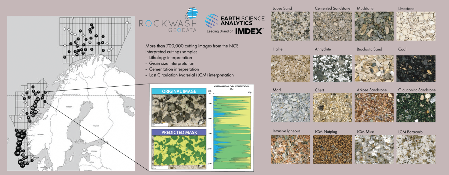
A persistent challenge in subsurface geoscience is the underutilisation of legacy data. Historical wells, logs, and physical samples often exist in inconsistent formats, making data integration and basin-scale analysis difficult.
EarthNET AI Wells applies machine-learning models across large populations of historical well data to support automated interval identification, lithology interpretation, and property estimation at scale. (Figures 1 and 3).
In parallel with analysis of well logs, EarthNET AI Images (Figures 1 and 4) applies computer vision to geological cuttings and core imagery, enabling automated lithology classification, semantic segmentation, and object detection. Together, these capabilities transform archived offshore data into analytics-ready datasets that can be reused consistently across projects.
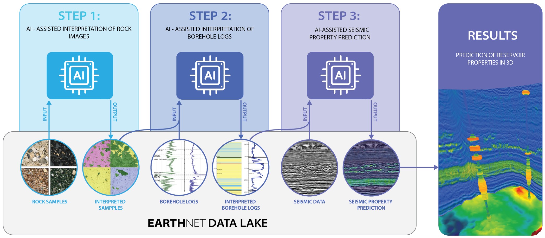
Subsurface data analysis in the energy industry is ultimately done to support decision-making related to exploration, field development or production. The decisions that we as subsurface domain experts are supporting need input from multiple datatypes and scientific disciplines. To support these decisions, we therefore need to interpret and analyse each relevant datatype, as well as integrate the analysis of each datatype and scientific discipline.
EarthNET offers applications for both manual, semi-automated and fully automated interpretation of individual datatypes using AI models. EarthNET also enables the concept of integration through the data layer, i.e. the EarthNET Data Lake. This enables propagation of information across datatypes and scientific disciplines.
In the example illustrated in Figure 4 the output derived from interpretation of core and cuttings data (Step 1) is used as input to the interpretation of well-log data (Step 2). The output from the interpretation of well-log data is used as input to the interpretation of seismic data (Step 3).
This example is only one of many examples of integrated workflow one can execute using EarthNET. The end result of this workflow is a set of regional facies or lithology volumes and associated confidence volumes that can be used in reservoir characterization. The high level of automation enables subsurface professionals to do this type of work with very little resource use, and can thus leverage the resulting insights early in the exploration and production value chain.
Exploring for overlooked opportunities – from missed pay to new drilling targets
Open digital ecosystems and connected digital workflows (Figure 4) enable subsurface teams to rapidly screen large well-populations, compare stratigraphic intervals, and identify areas of interest early in the project lifecycle. Using EarthNET analytics and visualisation tools, outputs from AI wells, AI images and EarthNET AI seismic properties can be analysed together, supporting rapid offshore field screening and early-stage subsurface modelling based on integrated datasets rather than isolated studies (Figure 2 and 5).
Early adoption of AI for subsurface workflows has been focused on using a single datatype rather than on extracting insights by integrating multiple datatypes.
Examples of single datatype usecases include (i) fault-interpretation using deep-learning methodologies, (ii) filling of missing well logs using various machine-learning algorithms, and (iii) interpretation of facies from core imagery. Examples of integrated use cases include (i) from core and cuttings to petrophysics interpretation, (ii) from core to seismic, and (iii) PhysicsInformed Neural Networks for seismic property prediction that have learned both from sample data, well-log data and from established geophysical relationships and knowledge.
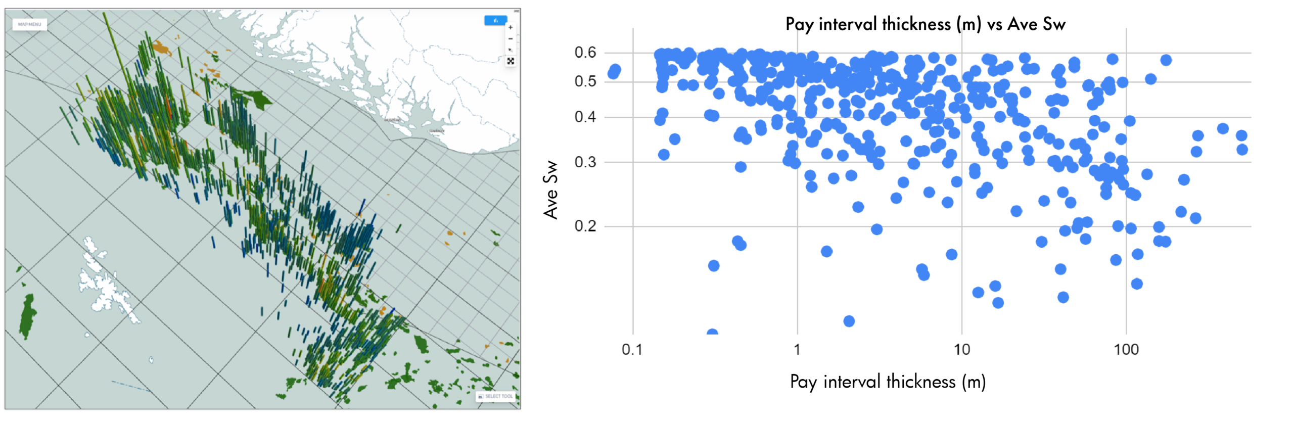
EarthNET is being used in the North Sea to identify overlooked pay intervals in legacy wells from both the Norwegian and UK sectors. These studies highlight exploration opportunities in a mature basin. Several hundred pay intervals have been identified in parts of wells that were previously thought to be dry. Energy companies are using this large database of overlooked pay intervals as a starting point for further evaluation of exploration opportunities. Some of the pay intervals are thick with significantly reduced water saturation and some thinner and more subtle. Also the subtle ones may be “smoking guns” that can lead to commercially attractive opportunities when pursuing them further using seismic data.
Scalable workflows across offshore regions
While early digital initiatives focused primarily on mature basins, the same workflows are now being applied across Europe , Asia-Pacific and the Middle East. Because EarthNET workflows are cloud-native and data-format-agnostic, Earth Science Analytics has applied the same AI-enabled approaches across regions with varying data density and subsurface maturity, supporting faster understanding and more consistent decision-making at portfolio scale (Figures 3, 4, 5 and 6).
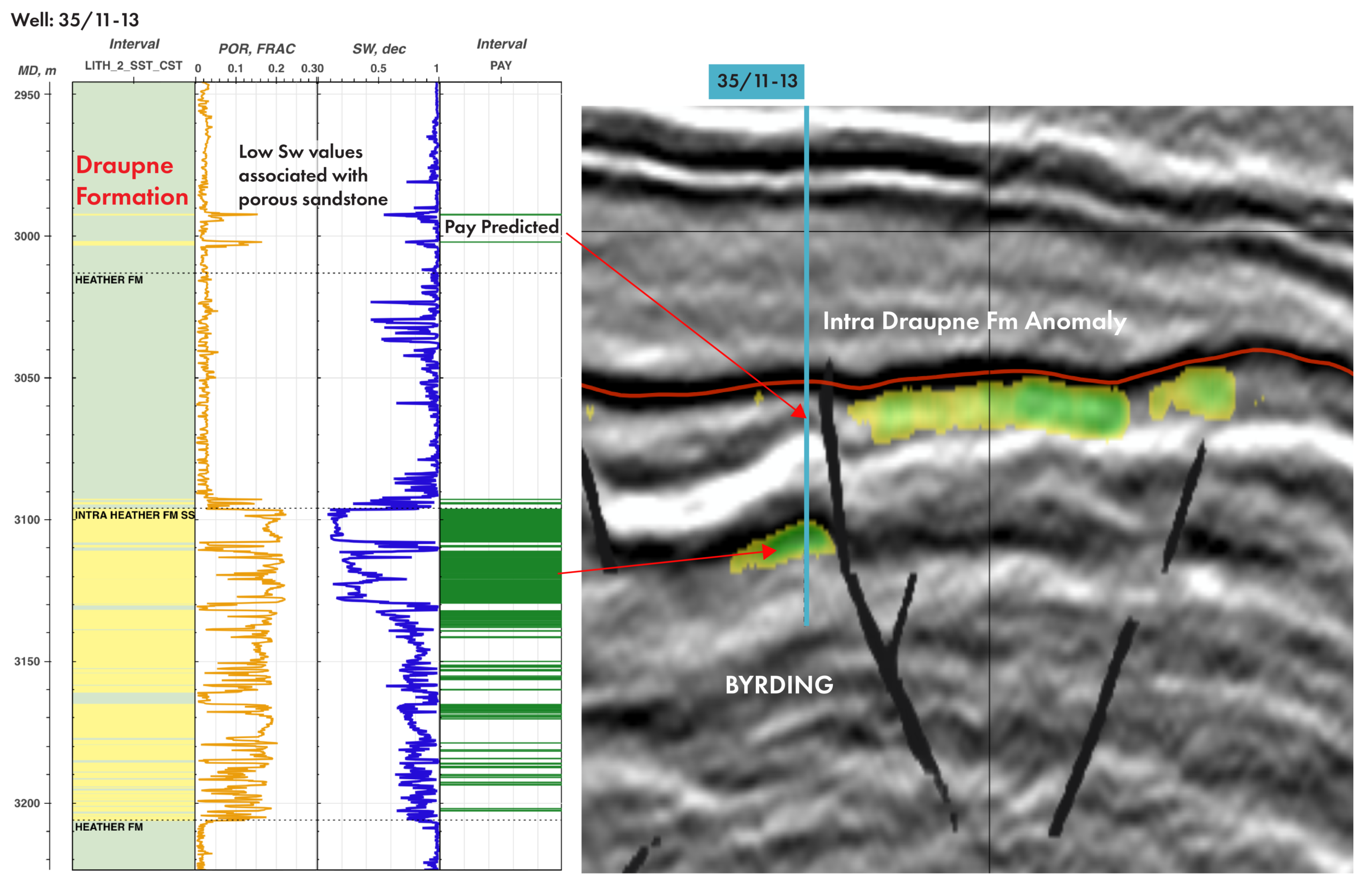
EarthNET enables integration across datatypes, and propoagation of information from the well domain to seismic domain. The example in Figure 6 illustrates two very thin pay intervals that were identified in the overburden (in the Draupne Formation) above a known accumulation (in the Heather Formation). The analysis was taken further from the initial well analysis into the 3D domain using EarthNET’s 3D seismic property prediction module. The seismic property prediction delivered a facies volume, a porosity volume and a water saturation volume. Automatic fault and horizon interpretation was carried out to define the structural and stratigraphic framework.
The extended study revealed that there was a commercially viable exploration opportunity present in the Draupne Formation across the fault from the initially discovered accumulation. This example illustrated that although being thin, the missed pay interval that was revealed in the well lead to an attractive exploration opportunity laterally after integrating the well data with seismic data.
Working alongside OSDU™ implementers
Interoperability remains a key requirement for enterprise digital strategies. EarthNET is designed to integrate with OSDU™-based data platforms, with EarthNET Data Lake supporting OSDU™-compatible ingestion and export (Figure 7). AI-derived interpretations from AI wells and AI images can be delivered back into enterprise environments, ensuring alignment with corporate data governance while enabling advanced subsurface analytics.
So, is there still a first-mover advantage in digital subsurface workflows?
The answer is yes – but it no longer comes from adopting technology first. The advantage lies in how effectively digital workflows are embedded into everyday subsurface work. Teams that connect dataplatforms, AI-enabled analytics, and geological expertise into operational workflows move faster, learn continuously, and reuse insight at scale.
EarthNET and Earth Science Analytics have led this digital transformation, delivering proven, actionable results across subsurface projects in Europe, the Middle East, and Asia. By applying AI within connected digital workflows – rather than as isolated tools – they enable organisations to unlock value from existing data, whether OSDU™ compliant or not, and whether working with wells, cores, cuttings, seismic, or integrated studies.
For energy companies ready to move from digital adoption to digital execution, the opportunity remains very real.
To learn how your subsurface data can deliver deeper insight and lasting value, contact Earth Science Analytics.