Recent offshore gas discoveries have renewed interest in the Eastern Mediterranean region and its reassessment for hydrocarbon potential. In order to develop a detailed geological understanding of a region, and efficiently target exploration efforts, it is important to bring together modern technologies from a range of disciplines. Increasingly, data acquired from orbiting satellites are supporting upstream activity, providing unique information for areas that are often remote or inaccessible.
During the exploration stage of a project, satellite data can contribute in two main ways. Firstly, radar sensors can identify oil on the sea surface sourced from natural seeps, while optical data and elevation models can also be used to assess surface geology, including structure and stratigraphy. Together this represents a proven approach that has been used by oil exploration companies worldwide.
To support exploration in the Eastern Mediterranean region, Airbus Defence and Space, Geo-Intelligence therefore recently reassessed the area in order to produce a non-exclusive study that combines the location of offshore oil seeps with a regional evaluation of onshore geology at 1:100,000–1:500,000 scale.
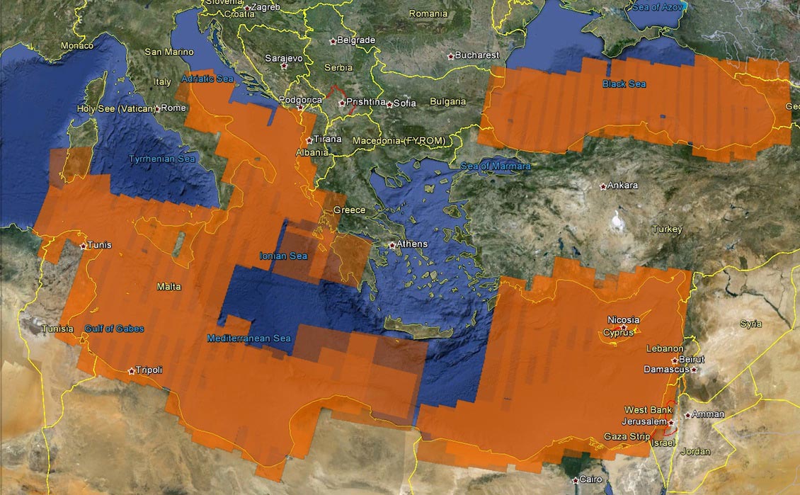
Coverage of radar scenes (orange) for the East and Central Mediterranean region used for identifying natural oil seeps on the sea surface. Reduced transparency indicates greater repeat coverage. Source: Airbus Defence and Space, Geo-Intelligence
Offshore Oil Seeps
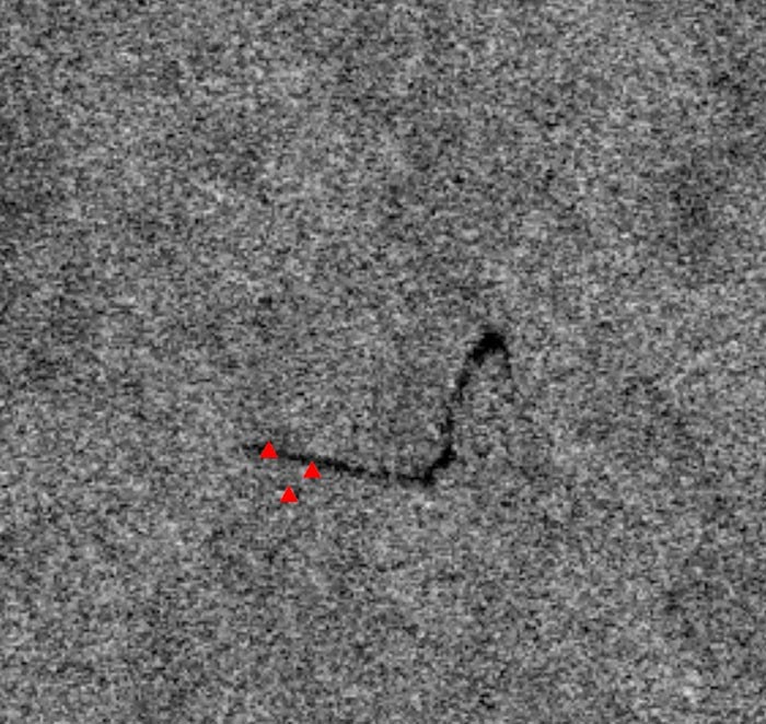 Example of a radar image showing a hydrocarbon seep located in the Levantine Basin. Multiple source points are shown (red triangles) based on multi-date imagery. Source: Airbus Defence and Space, Geo-IntelligenceAirbus Defence and Space, Geo-Intelligence has interpreted over 13,000 satellite scenes for the purpose of mapping natural oil slicks for its Global Seeps database, which is a non-exclusive database of offshore oil slicks, constructed by systematically screening the world’s offshore basins using a wide range of archive and newly programmed satellite data. The database now contains over 14,000 identified potential seepage slicks, including slick source points, slick vectors, probable slick type and confidence levels.
Finding slicks on the sea surface is an indicator of a working petroleum system within a basin. The methodology is based on the dampening effect oil has on wave amplitude, which directly influences the backscatter returned to the radar sensor on the satellite. What we are effectively observing is the influence that oil is having on wave conditions, rather than the oil itself.
So how can we make sure that we are not confusing a natural seep with an external factor such as pollution from shipping? Critical to this distinction is the use of repeat satellite coverage with a time separation of months or even years. Persistent seeps seen repeatedly over the same area would indicate a natural source as opposed to a pollution incident. This enables slick features to be assigned a confidence level based on specific criteria.
An Indication of Deep Oil?
Discoveries in the southern Levantine Basin by Noble have largely consisted of biogenic gas with reservoirs located in Lower Miocene/Oligocene sands lying beneath the Messinian Salt. But a Mesozoic source of thermogenic oil and gas is also a possibility. A study by the USGS has estimated a mean of 1.7 Bb of recoverable oil in the Levant Basin Province.
Based on the interpretation of the radar data, a number of oil slicks have been identified in the Levantine Basin, with particular concentrations adjacent to the Lebanon and Israel coasts, and directly south of Cyprus. Results indicate the offshore Nile Delta is also particularly prolific in terms of oil seeps, with a number of high confidence features. Further investigation is needed as to whether these oil slicks could be originating from this deeper oil source, where a suitable migration pathway exists.
Information on oil slicks is especially valuable when integrated with other datasets, particularly seismic data. Other studies in the region (Roberts and Peace, 2007; Peace and Johnson, 2001) have made comparisons between seismic and seep locations. Correlations have been observed with Direct Hydrocarbon Indicators, bright spots, flat spots and gas chimneys. In addition seeps were also associated with clear migration pathways through deep-seated major faults.
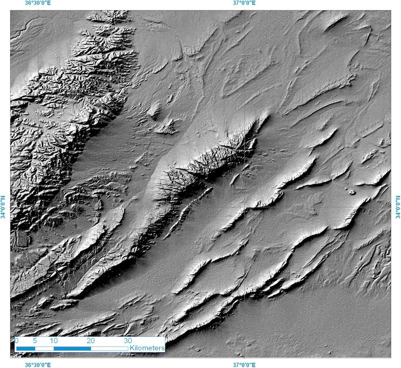
Landsat imagery and SRTM data are used to produce a regional geological interpretation (as shown below and at top of page 26) for the Palmyride mountain belt in Syria. Using satellite imagery in this way helps develop a better understanding of the nature and orientation of folding within the Syrian Arc which has implications for the hydrocarbon potential of structures offshore. Source: Airbus Defence and Space, Geo-Intelligence
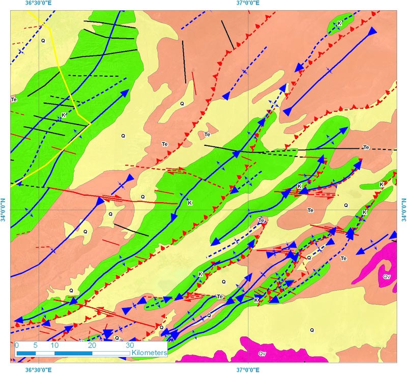
Landsat imagery and SRTM data are used to produce a regional geological interpretation (as shown below and at top of page 26) for the Palmyride mountain belt in Syria. Using satellite imagery in this way helps develop a better understanding of the nature and orientation of folding within the Syrian Arc which has implications for the hydrocarbon potential of structures offshore. Source: Airbus Defence and Space, Geo-Intelligence
Creating a Regional Geological Context
Geological mapping from satellite imagery is an established technique, with medium 15m resolution earth observation data such as Landsat providing a rich information source for efficiently undertaking geological interpretation over extensive onshore areas. Primary data collection includes structural information such as relative bedding dip and orientation and fault identification and classification, which together with spectral and textural information allows for the assessment of surface stratigraphy.
An understanding of the regional setting provided by satellite data delivers important context that simply is not achievable from ground-based observations alone. Onshore interpretation was undertaken from Tunisia to Turkey, covering Libya, Egypt, Israel, Lebanon and Syria, and leading to the creation of a seamless digital GIS dataset. The study has revealed a number of previously unmapped structures as well as providing geological context to the offshore study. For example, developing a better understanding of the nature and orientation of folding within the Syrian Arc may lead to a greater understanding of offshore structures.
Follow-up work using higher resolution data from the constellation of satellites such as SPOT 6 (1.5m resolution) and Pleiades (0.5m resolution) has also been conducted over specific areas. Through this it is possible to derive more detailed geological mapping, of great importance as regional screening progresses to individual licence block evaluation.
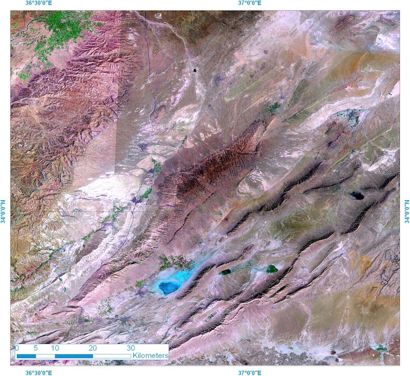
Landsat imagery of the same area in the Palmyrides as shown on page 24, this time in a 742 (RGB) pseudo-colour band combination. This band combination, incorporating the short wave infra-red, enhances surface lithological variation. Source: Airbus Defence and Space, Geo-Intelligence
Exciting Potential
The Eastern Mediterranean presents an exciting area for oil and gas exploration, with great potential, as indicated by discoveries over recent years. Remote sensing technologies have an important contribution to make in terms of regional screening and targeting, both onshore and offshore. With further drilling planned, and the presence of potential oil seeps across the region, is the occurrence of deep oil a possibility?
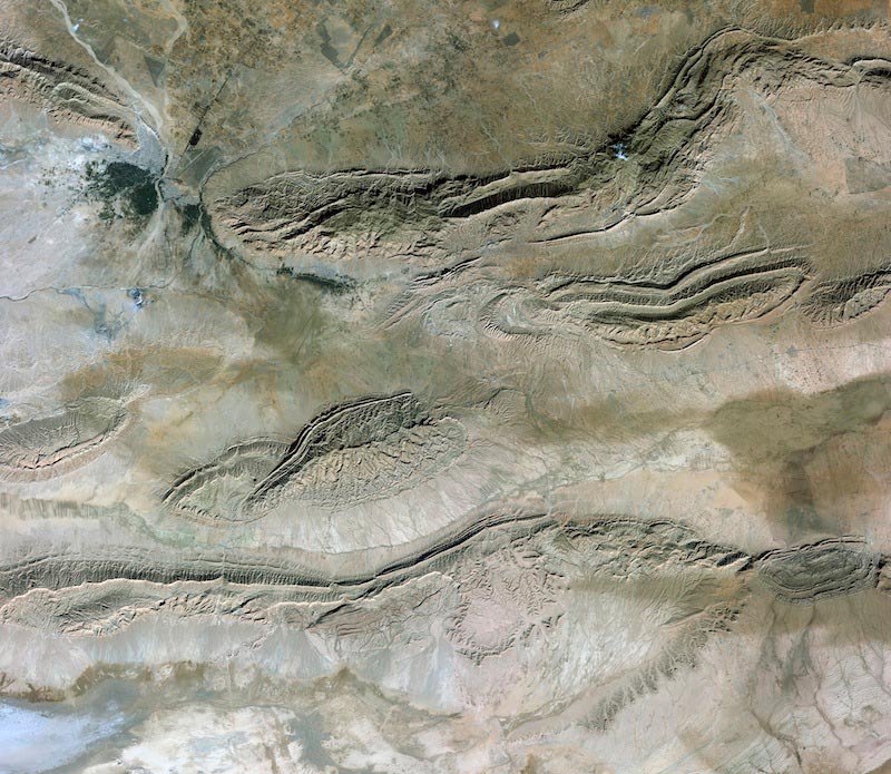
Imagery for Tunisia from the recently launched SPOT 6 satellite offering imagery at 1.5m resolution can be used to produce a detailed interpretation of surface geology for key areas. Source: Airbus Defence and Space, Geo-Intelligence


