Neil Hodgson, Anongporn Intawong and Karyna Rodriguez; Spectrum Geo Ltd
Spectrum’s Black Sea MC 2D data. An extraordinary underexplored basin New data reveals the potential for a new super basin – an accessible oil play lying within the world-class Maykop oil…
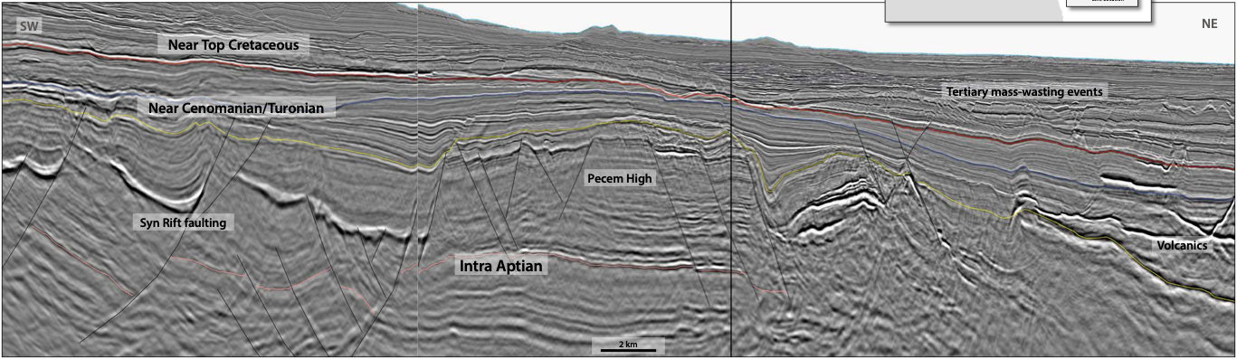
GeoStreamer Data Reveals Exploration Potential PGS GeoStreamer 3D datasets are positioned to give explorers in Ceará and Potiguar the best opportunity to de-risk these play fairways and prospects. Significant shallow…
Location of the XArray Triple Source project which will cover the Aram, Carcará and Uirapuru areas. Map showing fields and location of newly awarded acreage (Uirapuru) and the Aram,…
Explore Madagascar’s open acreage The West Morondava Basin: Let the bidding commence! After over 100 years of exploration, the offshore part of the West Morondava Basin remains largely underexplored. Only six…
Rune Sakariassen, Nicola O’Dowd and Sören Naumann, PGS
A Vast, Underexplored, Complex Geological Province Brand new, high resolution, 3D multicomponent seismic data from PGS has enhanced the geological understanding of one of the last remaining frontier basins in…
Matt Tyrell, Joshua May and Eric Mueller; PGS, Orlando Pontes; ANP-STP
Base map showing the territorial waters of the STP-EEZ together with neighbouring countries. The PGS MultiClient seismic and well datasets are shown together with annotations showing the major fluvial input…
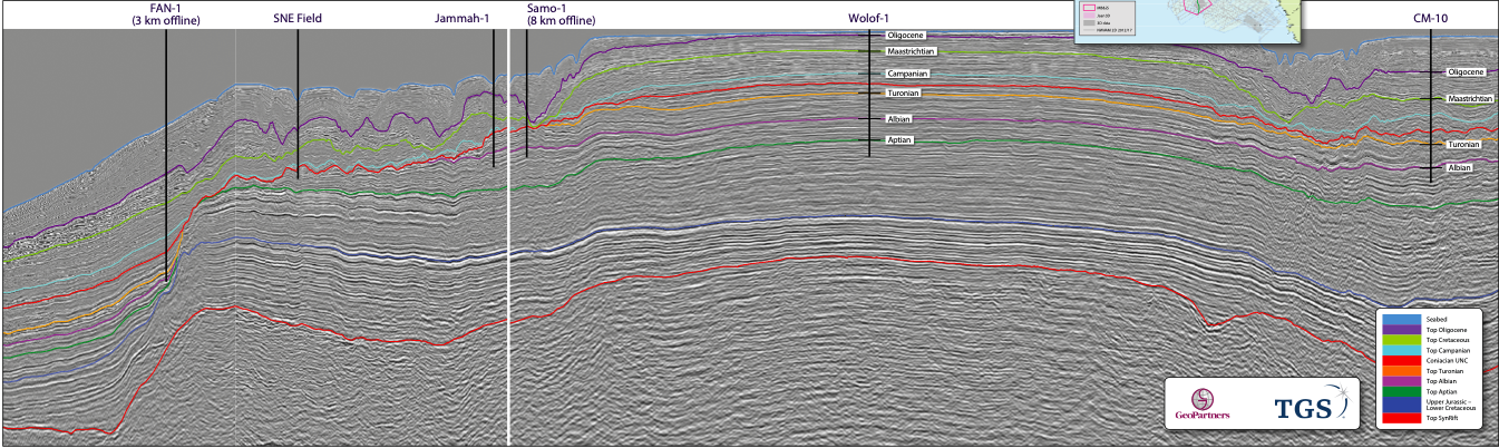
Why the MSGBC Basin? The MSGBC Basin is ready for something new to help analogue-chasing the next SNE oil field. Prior to 2014, with doubts over the actual commercial success…
Neil Hodgson, Karyna Rodriquez and Paolo Esestime; Spectrum Geo
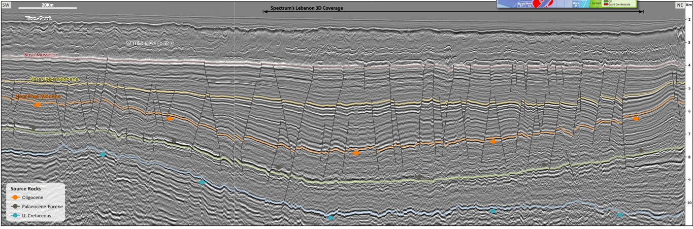
Extraordinary hydrocarbon potential Offshore Lebanon As Jane Austen might have said: “It is a truth universally acknowledged, that exploration companies possessing acreage in the Eastern Mediterranean must be in want…
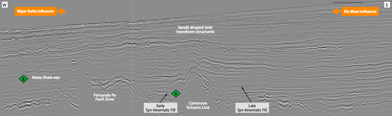
PGS modern broadband seismic coverage of Côte d’Ivoire now provides complete coverage of the area from source to sink. Stratigraphy and Tectonic Phases: West Africa Transform Margin (WATM) Figure 1a:…
Satinder Chopra, Ritesh Kumar Sharma, Hossein Nemati, and James Keay; TGS
Location of the TGS 3D surveys in eastern Ohio. Seismic reservoir characterization with efforts at quantitative interpretation: a case study Eastern Ohio has become a new drilling target and the focus…
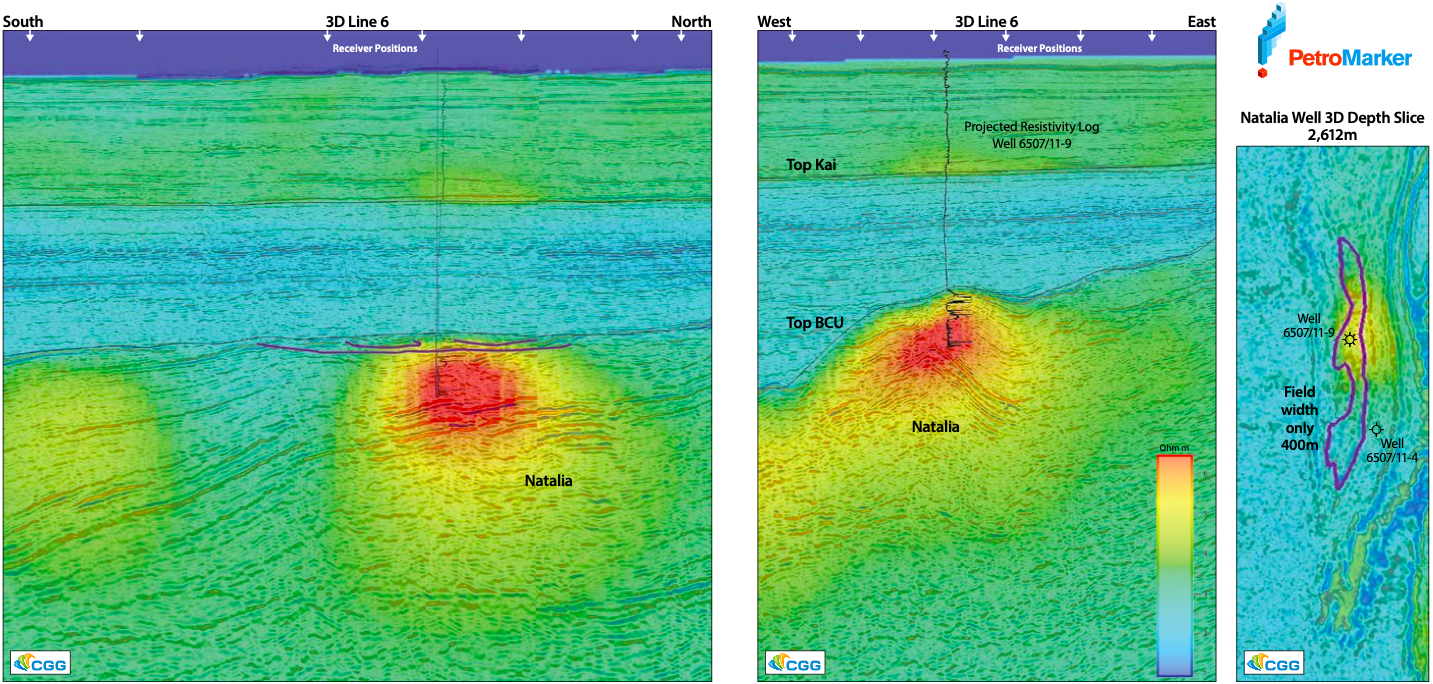
Natalia Discovery Shown by EM Data The discovery well proved about 40m gas column in the Jurassic Garn Formation, with a gas-down-to in the Not Formation at 2,637.8m. The hydrocarbon…
Bent Kjølhamar, Jan Langhammer, Nick Woodburn, Reidun Myklebust and Simon Baldock; TGS.
Figure 1: Location of the TGS Atlantic Margin 3D seismic project in the Norwegian Sea. Figure 2: Top Eocene horizon across the Atlantic Margin North 3D in the Southern Vøring…