
Uruguay is located in South America between Brazil and Argentina and on the edge of the Atlantic Ocean. It is the second-smallest nation in South America, with a land surface area of 176,215 km2 and a total area of 318,413 km2, including rivers and territorial waters. The population is slightly more than 3,285,000, 40% of whom live in Montevideo, the capital city.
There are no remarkable topographic features; most of the country’s landscape consists of rolling plains and low hills ranging with fertile coastal lowland – but the country does boast 660 km of stunning coastline with beautiful beaches. The weather and topographic features make Uruguay especially suitable for agriculture, forest and livestock production, which together represent the main sources of gross domestic product within the country. Uruguay has long-standing traditions of democracy and legal and social stability, and has a solid financial and legal framework which makes it attractive to foreign investors looking for business ventures in the region.
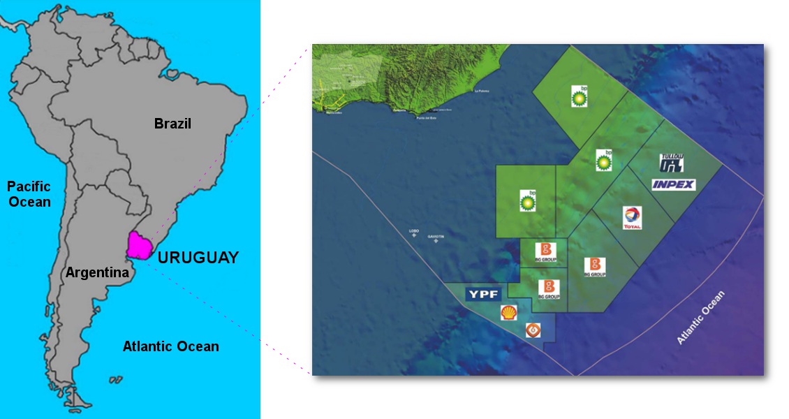
Uruguay, located on the Atlantic seaboard of South America, with map showing blocks awarded in the second bidding round in 2012.
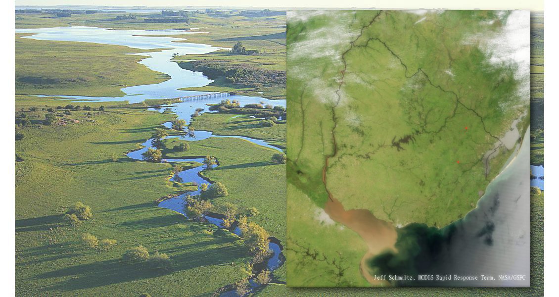
Uruguay is dominated by a rolling plateau with ranges of small hills and is ideally suited to cattle and sheep ranches. (Source: Courtesy of Uruguay XXI)
Reviving Exploration
Offshore exploration history in Uruguay has been very discontinuous and limited. The 1970s saw the acquisition of about 12,000 line km of seismic, mainly focused in the Punta del Este Basin, followed by the drilling of two shallow water exploratory wells by Chevron in 1976. Two further 2D seismic surveys of 1,400 km and 1,800 km were carried out in 1982 and 2002, respectively, while between 2007 and 2008 a regional 2D seismic survey of 10,000 km shed some light on the almost unknown provinces of the Pelotas and Oriental del Plata Basins.
 Montevideo is the largest city in Uruguay and home to around 40% of the country’s population.Following the 2007–2008 seismic acquisition, offshore bidding rounds constituted the favoured approach for ANCAP (the national oil company of Uruguay) to attract investment by international companies. The first bidding round took place in 2009, in which two exploration and production contracts were awarded to a consortium formed by Petrobras, YPF and GLP. The second bidding round in 2012 was even more successful, and as a result of it, eight blocks were awarded, three of them to BP, three to BG, one to Total and one to Tullow Oil.
As a result of the committed exploratory work carried out by the operators, together with other surveys undertaken by ANCAP, Uruguayan offshore basins are now covered by more than 39,100 km2 of 3D seismic (16,300 km2 of multi-client and 22,800 km2 of exclusive surveys), 13,000 km2 of 3D electromagnetic surveys and 40,000 km of 2D seismic, 35,000 km of which is multiclient. After 40 years without any wells drilled offshore Uruguay, Total will soon drill the first exploratory well in ultra-deep waters in the Pelotas Basin.
Three Offshore Basins…
Three basins are recognised offshore Uruguay: the Punta del Este Basin in the west, the Pelotas Basin to the east and the Oriental del Plata Basin to the south in ultra-deep waters.
The genesis of these basins is related to the break-up of the supercontinent Gondwana and the opening of the South Atlantic Ocean in the Late Jurassic-Early Cretaceous. The offshore basins have a total extent, up to the 200 nautical-mile limit, of more than 85,000 km2, and a maximum volcano-sedimentary fill of 8,000m, based on seismic data. The water depths range from less than 20m to more than 4,000m.
The only two exploratory wells drilled in the offshore were located close to each other in the Punta del Este Basin in very shallow waters between 40 and 50m. These were Gaviotín-1 and Lobo-1, with total depths of 3,631m and 2,713m respectively. Both were declared dry, and they did not find significant source rock intervals, although fluid inclusions of light oil (36° API) and gas were shown to be present throughout the sedimentary column. The main reason for not finding source rocks in these wells appears to be related to their proximal situation regarding the basin.
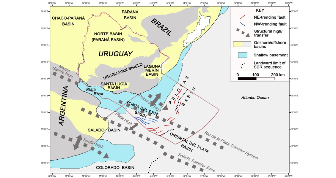
Location of the offshore basins of Uruguay. (Source: Soto et al. 2011)
The Punta del Este Basin is a funnel-shaped aulacogen which is separated from the Pelotas Basin to the east by the Polonio High.
The Pelotas Basin, which corresponds to the flexural border of a precursor syn-rift structure and developed on continental, transitional and oceanic crust, extends from the Polonio High up to the Florianópolis Fracture Zone in Brazil, close to the edge of the Santos Basin.
The ultra-deepwater Oriental del Plata Basin developed over transitional and oceanic crust. Its sedimentary fill reaches 5,000m and comprises Cretaceous and Cenozoic marine sequences.
… And Three Mega-Sequences
Three main mega-sequences are recognised in the offshore basins: they are pre-rift, syn-rift and post-rift.
The pre-rift mega-sequence corresponds to units preserved from an older basin that developed in the proximal segment of the Punta del Este and Pelotas Basins and is known through Permian sedimentary sequences found in the Gaviotín well at between 3,492 and 3,631m. These can be correlated with the Permian units of the onshore Palaeozoic- Mesozoic Parana Basin.
The syn-rift mega-sequence is represented by volcanic and sedimentary units deposited during the rifting of the supercontinent Gondwana. It includes alluvial-fluvial and lacustrine deposits interbedded with volcanic and volcaniclastic rocks, which fill a series of deep asymmetric hemigrabens developed in the proximal segment of the Punta del Este and Pelotas Basins. The syn-rift is also represented in the distal part by seaward dipping reflectors.
Two sequences can be identified in the post-rift mega-sequence: transition and drift. The transition sequence is recognised in the Punta del Este Basin, and includes fluvial-deltaic systems and distally marine systems. It was deposited during a period of thermal subsidence after the end of the rift mega-sequence (marked by the break-up unconformity). The drift sequence, which can be divided into a Cretaceous early drift and Cenozoic late drift segment, has a maximum total thickness of 5,500m based on seismic data and is characterised by several sequences of minor order associated with transgressions and regressions of the sea level. These sea level changes resulted in the deposition of several marine source rocks of good quality during the transgression periods, and in times of regression reservoir rocks of continental and marine origin such as channels, deltaic prograding fronts and turbidites were deposited.
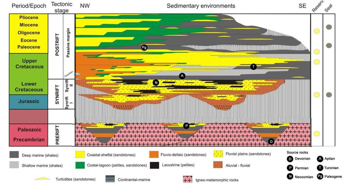
Petroleum system model showing source, reservoir and seal rocks offshore Uruguay.
Proven Petroleum Systems
The main potential source rocks are related to the three mega-sequences identified. In the pre-rift, a lower Permian source rock has been proven in the Brazilian part of the Pelotas Basin. This was deposited in a restricted marine environment represented by marine oil shales with TOC levels up to 13.5%. Within the syn-rift sequence thick lacustrine source rocks have been interpreted on seismic, most importantly in the Punta del Este Basin.
The base of the post-rift sequence shows a clear transgressive character with the deposition of marine Aptian source rocks. These correspond to the first oceanic anoxic event of the Cretaceous, represented in several productive South Atlantic basins by black organic-rich shales. A second marine transgression during the Cenomanian- Turonian resulted in the deposition of a source rock that is also found in the Pelotas Basin in Brazil. Finally, there was a third important marine transgression of Late Maastrichtian-Middle Eocene age, which not only provides a regional seal but includes potential source rock levels, in spite of the fact that they probably only reached the oil window distally.
Proven high-quality reservoir rocks were encountered in the two wells, with porosity values between 18 and 25%, increased by fracturing and dissolution processes.
Different structural, stratigraphic and combined leads and prospects can be seen on the seismic sections in variable water depths, from shallow through to ultra-deep waters.
Plays in the pre-rift and syn-rift sequences include gentle anticline structures related to basement highs, rotated blocks, compaction synclines, lacustrine fans and pinch-outs against basement highs. Plays in the post-rift sequence include pinch-outs, channel complexes, and most notably turbiditic and basin floor fan systems.
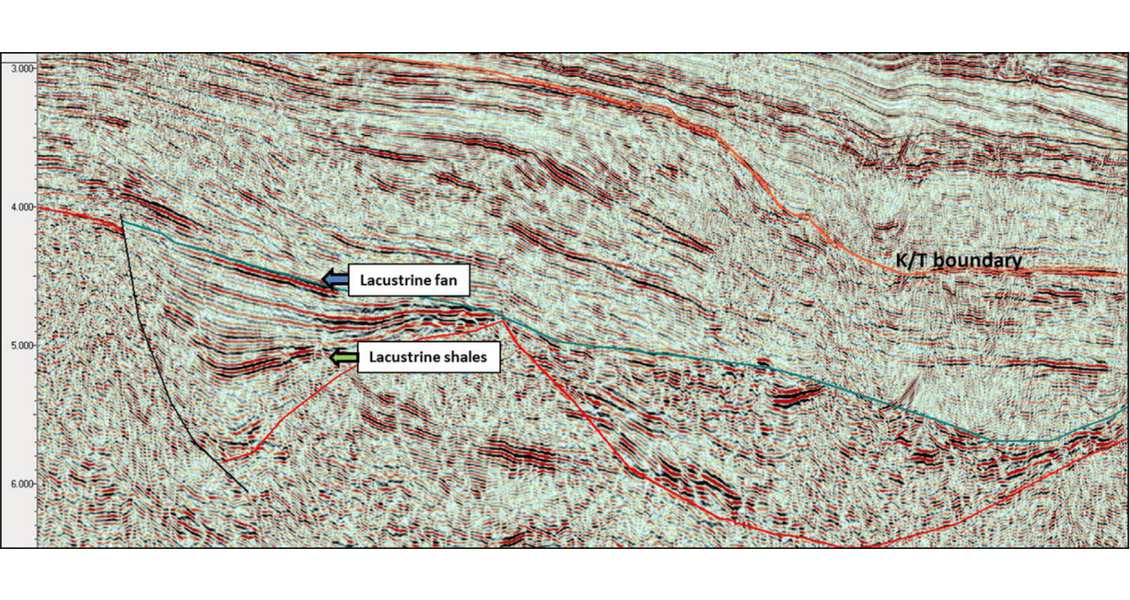
Seismic section showing a hemigraben with lacustrine shales and a lacustrine fan. (Source: Courtesy of Uruguay XXI)
New Opportunities
New areas offshore Uruguay in shallow, deep and ultra-deep waters will be offered to the industry in 2016 when the third bidding process, Uruguay Round 3, is released. The contract model, which will have similar characteristics to those signed in Uruguay Round 2, is a typical production sharing agreement, in which the contractor assumes all risks, costs and responsibilities for the activity. Offers for the available blocks will be compared taking into consideration the exploratory programme proposed over the minimum stipulations required, the percentage of profit split and the percentage of ANCAP’s association in the case of a commercial discovery.
Come and visit Uruguay, a wonderful place to do business, and with promising geology and fair contract terms.


