Unlocking offshore Greece: New regional GeoStreamer dataset provides key answers
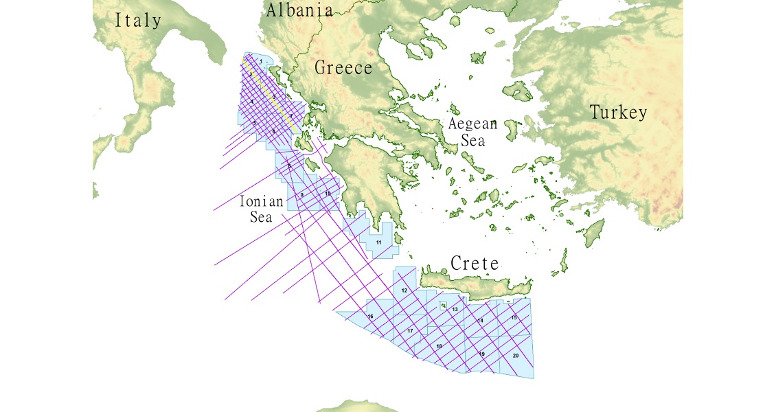
In preparation for the 2014 licensing round, PGS, on behalf of YPEKA, acquired 12,500 km of 2D seismic data offshore western and southern Greece. The exceptional quality of the new seismic data has allowed a confident delineation of the stratigraphic record and the various play types. The exploration blocks are now defined and, with the regulatory framework in place, the region is ready to be further explored.
With renewed interest offshore south-eastern Italy and recent light-oil discoveries onshore Albania (Shpiragu-2), the focus is once again on the southern Adriatic region. The Hellenides and the Albanides together are the mirror image of the Apennines, with discoveries in the external geotectonic zones and the fore deeps. There is a range of potential traps, including sub-thrust traps in the external zones, the karstified carbonate platform, re-sedimented carbonates along the platform edges, and stratigraphic pinch-outs within and at the basin margins. These are just a selection of the possible traps observed in the new dataset from the under-explored offshore Greece region.
Geological background
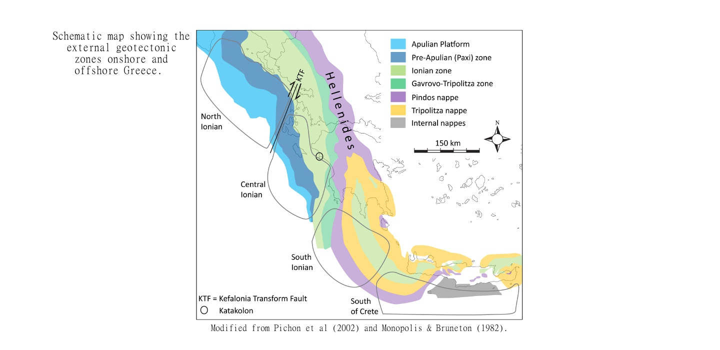
The geology of western and southern Greece has been influenced by the movements of the Eurasian and African plates since late Cretaceous times, when they began to converge and collide. The result is the Peri-Adriatic orogenic belt that extends from the Maghrebides in the south-west, via the Italian Apennines and extending eastwards, covering the Croatian Dinarides, the Albanian Albanides, and the Greek Hellenides. The Hellenides are a fold-and-thrust belt, and the prospective outermost part, the External Hellenides, encompasses the Ionian zone, Paxi zone and Apulian Platform. These geotectonic zones originated during the Mesozoic rifting of the southern Tethys margin, creating a platform-basin configuration.
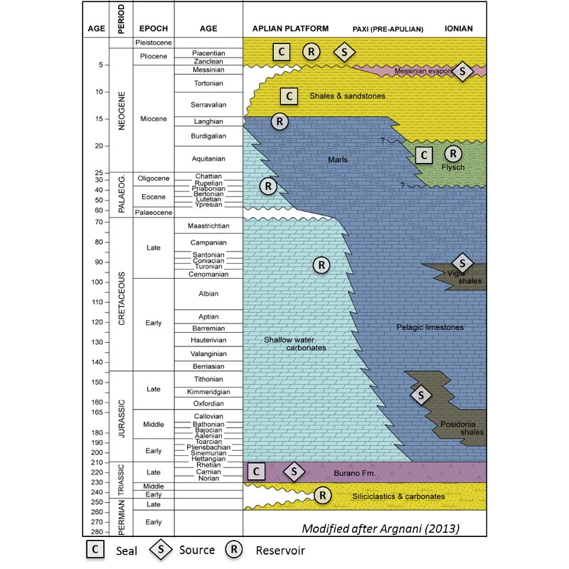
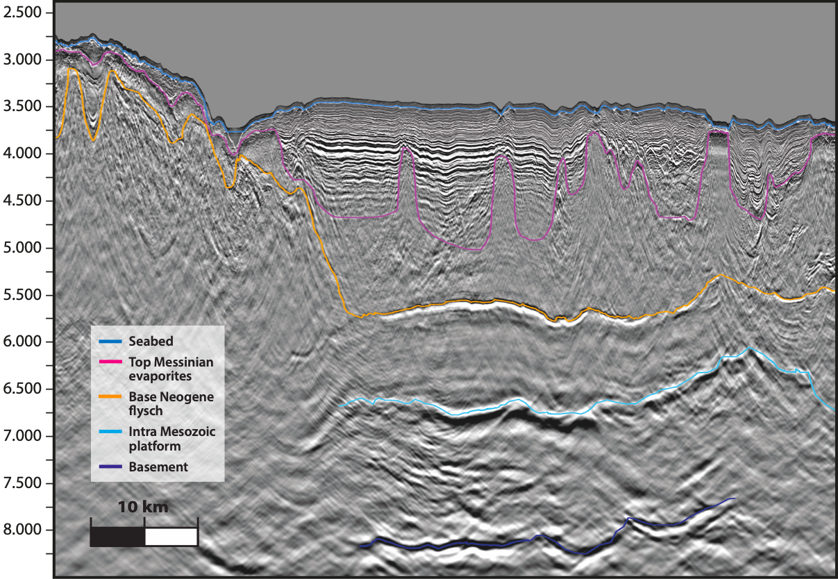
The stratigraphic succession of the external zones and the carbonate platform comprises predominantly Triassic breccia and evaporites, overlain by Jurassic to Eocene platform and pelagic carbonates, with younger carbonates in the Paxi zone and on the Apulian Platform. The platform is dominated by dolomitization in the Early Mesozoic succession, and by karstification in the Late Mesozoic and Early Paleogene succession. In the basin (Ionian), pelagic carbonates with cherts are abundant. With the onset of convergence and growth of the foldand- thrust belt, a foreland basin developed in the west; the carbonate deposition ceased and flysch dominates the post-Eocene succession in the Ionian zone. With the re-flooding of the Mediterranean in post-Messinian times, the Apulian platform was drowned and clastic input from the west-verging Hellenides and east-verging Apennines dominates the Pliocene to Recent strata.
Several source-rock intervals exist within the External Hellenides, mainly the Triassic Burano Formation or equivalents, which was deposited in a restricted basinal, marine environment adjacent to the carbonate platforms from Middle Triassic to Liassic time (Zappaterra, 1994). During the Jurassic rifting related to the Tethys Ocean created a platform-basin configuration (Gavrovo/Apulian – Ionian) and the organic-rich Jurassic Posidonia beds (Ammonitico Rosso equivalent [Mavromatidis, 2009]) were deposited within these rift-related sub-basins. The Cretaceous was the quiescent post-rift period during which continuous subsidence of the basin created stagnant conditions in deeper waters and allowed the deposition of the organic-rich Vigla shale member (Karakitsios, 2013).
Several play types
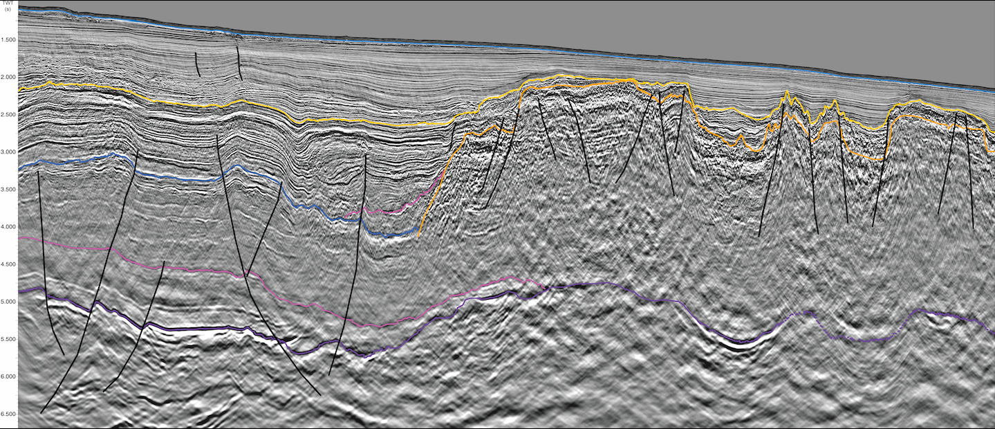
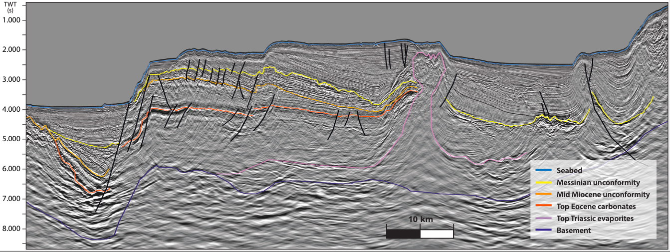
The development of the Hellenides nappes created potential hydrocarbon traps in the external zones in the form of sub-thrust traps, a play which is proven to the north in the Albanian part of the Ionian zone (e.g. Finiq Krane, Delvina, Ballsh Hekal). Strata upturned adjacent to salt diapirs, developed as a result of halokinesis, commonly form traps. This trapping mechanism, frequently encountered along the passive margins of West Africa and South America, is observed in the Central Ionian region (see image above).
Stratigraphic traps are common in the Neogene clastics of the Albanian Ionian zone, where molassic deposits unconformably overlie Oligocene flysch and carbonates (Patos-Marinza and Kucova). They are equally important in the Northern and Central Ionian regions. Further west, within the Paxi zone and on the Apulian Platform, the Italian analogs come into play, with karstic reservoirs (e.g. Rospo Mare), carbonate buildups (e.g. Giove) and shelf edge deposits (e.g. Falco), all proven plays.
The Southern Ionian and South of Crete regions are vast unexplored territories where several interesting features have been imaged for the first time. Amongst them are sub- Messinian anticlines and large anticlines within the Miocene sediments. There are three main play types in this area: the fold-and-thrust belt; anticlines related to strike-slip movements together with fault blocks related to normal fault activity; and the Mediterranean Ridge backthrust play. Identified hydrocarbon indicators include mud volcanoes and bottom simulating reflectors, the latter indicating the presence of gas hydrates.
Open licensing round
Greece is offering significant investment opportunities and attractive areas for exploration in the offshore license round, which is expected to close in July 2015. Twenty exploration blocks have been defined, the block sizes varying from approximately 2,000 km2 in the north up to 9,000 km2 in the south.
The initial exploration stage (divided into three phases), linked to a specific work program, is eight years, extendable under specific terms, whereas the exploitation period based on a development and production plan is 25 years, which can be extended. The lease agreement is based on a royalty and tax arrangement. Fiscal terms are attractive, with income tax of 20% and regional tax of only 5%. Block awards are expected to be announced in the third quarter of 2015.