
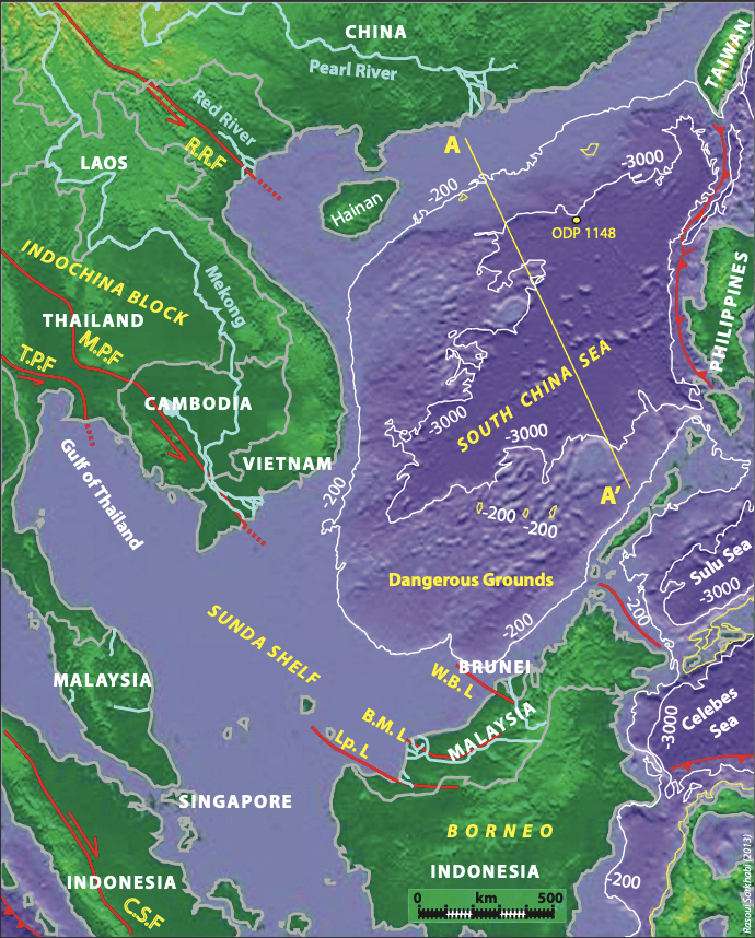
The South China Sea (SCS), which spans from Singapore and the Malacca Strait in the south to the Strait of Taiwan in the north, and from Borneo and the Philippines on the east to Vietnam and south-eastern China on the west, is one of the largest marginal seas in the world. Bordering eight countries, the SCS is important, among other things, for its international marine transportation and navigation, its rich marine biodiversity including fisheries, its impact on the monsoon climate of South East Asian countries, and its oil and gas resources.
The SCS’s numerous seamounts and islands are mainly coral reefs, atolls, shoals and sandbars, many of which are submerged at high tides and have no native inhabitants. They are usually clustered into geographical groups, notably the Spratly Islands and Reed Bank offshore the Philippines, Scarborough Seamounts along the central axis of the SCS, and Macclesfield Bank, and the Paracel and Pratas Islands in the north.
Complex geology and data secrecy
Geologically, South East Asia, including the SCS, is a mosaic of tectonic blocks located between the convergences of the Earth’s largest tectonic plates: Eurasia, Indo-Australia and Pacific-Philippine Sea plates. It is apparent that understanding the tectonic and stratigraphic evolution of the region has critical relevance for the exploration of oil and gas resources in the numerous basins of the region. However, despite an increasing number of studies since the 1980s, our knowledge of the geology of the region still remains poor for a variety of reasons: the geology is complex; the data are fragmentary and sporadic; the geologic information is scattered in various local publications, and the crucial subsurface and offshore information acquired by national and international oil companies largely remains in secrecy.
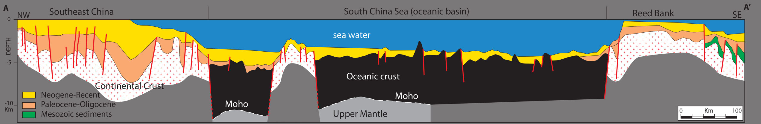
The SCS is an oceanic basin surrounded by Sundaland on the west and south-west and a chain of volcanic islands on the east. Sundaland is the continental basement-basin complex of South East Asia, developed since Palaeozoic times. It consists of the onshore Indochina Block and the offshore Sunda Shelf, extending to a water depth of 200m. The Sunda Shelf is a stretched continental crust and encompasses the majority of explored petroleum basins in South East Asia. The continental slope, which ranges from 200 to 1,000m, is narrow and steep. The oceanic crust begins at water depths of 3,000–3,500m, and extends to water depths of over 5,000m.
Gravity inversion data as well as deep seismic surveys indicate that crustal thickness (depth to the Moho) of the SCS varies from 30 km in the Sunda Shelf through 18–12 km in the Dangerous Grounds to 11–7 km beneath the oceanic crust. Sediment thickness on the oceanic crust is 1–2 km, while that on the Sunda Shelf within deep grabens exceeds 12 km in places.
Patterns of sea floor spreading
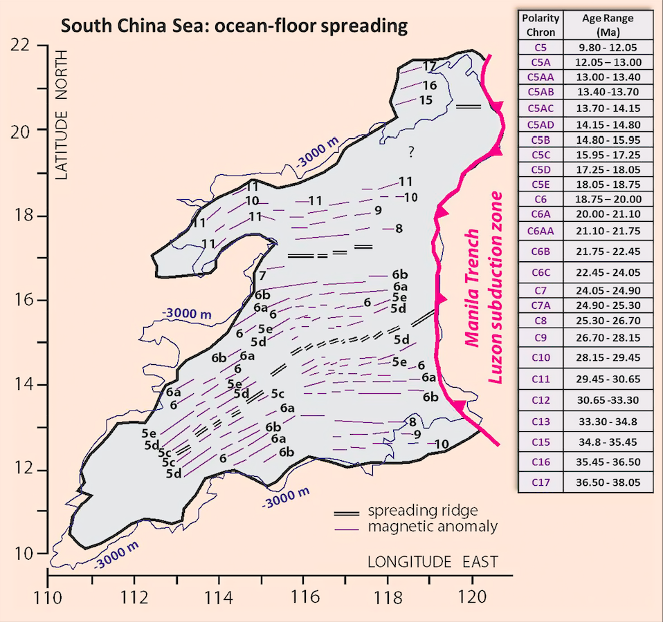
Examination of seafloor magnetic lineations indicates that the SCS oceanic basin opened between magnetic anomalies (polarity chrons) 11 and 5C, which respectively correspond to the geologic times 30 Ma and 16.6 Ma, according to the Gradstein et al. (2004) geologic time scale, or 32–16 Ma according to the older version. These data further show that the ocean basin opened in at least two major phases. During phase I, from 30 Ma to ~21 Ma, the seafloor spreading was north to south, with the spreading ridge striking east-west, and as a result the continental block containing the present North Palawan Island, Reed Bank, Macclesfield Bank and Paracel Islands was separated from the South China continental block to the north. At magnetic anomalies 7-6B (between 24.9 and 21.75 Ma) the spreading ridge jumped to a north-east–south-west trend, with the seafloor spreading in a north-west–south-east direction, which eventually separated Reed Bank from Macclesfield Bank.
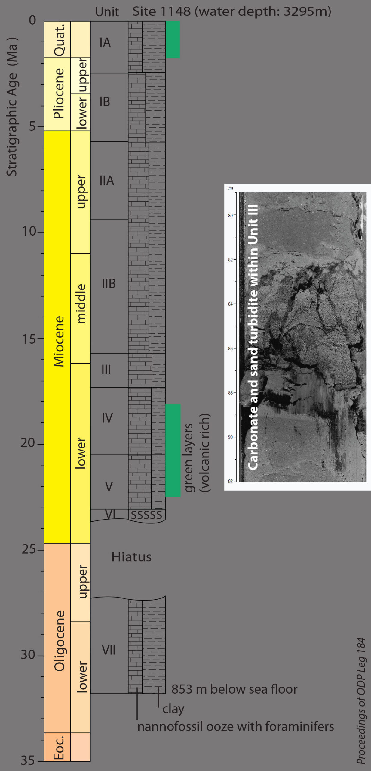
While this chronology of the opening of the SCS is widely known, it is by no means a final scenario. S.K. Hsu and his Chinese colleagues (Marine Geophysics Research, 2004, Vol. 25) have identified even older magnetic anomalies dating back to C17 in the north-eastern corner of the SCS which puts the seafloor spreading in that part at ~37 Ma. In any case, the interpretations of magnetic anomalies need to be corroborated by drilling data from the SCS floor.
The opening of the SCS within the larger framework of South East Asian geology has been a subject of debate among scientists for several decades, and a few models have been proposed, which are briefly discussed below.
Indian indentation and South East Asian extrusion
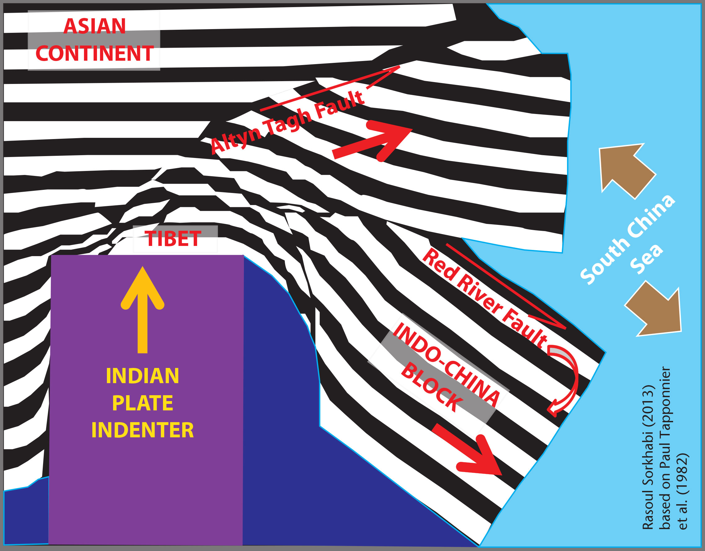
One popular tectonic model for the origin of the SCS was proposed by Paul Tapponnier and his French colleagues (Geology, 1982, Vol. 10). In an experiment involving indentation of a rigid block against a deformable plastic material, these researchers examined the effect of the collision of the Indian plate (a Precambrian shield) against the relatively ‘soft body’ of Asian continent, a basement-sedimentary complex which was subjected to multiple phases of tectonic deformation in Palaeozoic and Mesozoic times. This idea was based on the Swiss geologist Emil Argand’s interpretation in his La Techtonique de l’Asie (1924): that the collision of the rigid India with the plastic Asia during the ‘Alpine [Himalayan] orogeny’ caused not only north-south dipping folds and thrusts (in the direction of the collision) but also eastward ‘flow’ of rocks in eastern Asia.
The India-Asia collision took place at about 55–50 Ma, and since then the Indian plate has been pushing against Asia at a rate of about 5 cm per year, resulting in 2,500–2,000 km of continental deformation. Tapponnier and his colleagues, based on a comparison of their experimental results with a tectonic map of Asia, suggested that after the collision, between 50 and 20 Ma, the Indochina Block was extruded south-eastward (out of the way of the indenter) for 800 km along the then left-lateral Red River Fault, which spans from eastern Tibet to northern Vietnam. This tectonic escape and clockwise rotation of the Indochina Block was interpreted to be responsible for the opening of the SCS during this period. After 20 Ma, the extrusion tectonics shifted to other strike-slip faults in central Asia, thus terminating the seafloor spreading in the SCS and opening new extensional basins in continental Asia.
This elegant model has been elaborated on by many other researchers, and it indeed offers a useful perspective on the strike-slip motions and associated pull-apart basins in Central and South East Asia as a result of the Indian collision in Cenozoic times. Geochronological data from rocks along the Red River Fault suggest fault activity to be in the Oligocene-Early Miocene, and total movements on the fault have been estimated to be several hundreds of kilometres. Nevertheless, the direct relevance of the Red River fault activity for the opening of the SCS has also been questioned. For one thing, it is not clear how the Red River Fault extends offshore and is linked to the seafloor spreading structures. Moreover, magnetic lineations of the SCS show that the seafloor spreading began in the east to north-east (far from the Red River Fault) and then ‘unzipped’ in a west to south-west direction, thus creating a wedge-shaped sea with its maximum width in the north-east.
Subduction and crustal extension
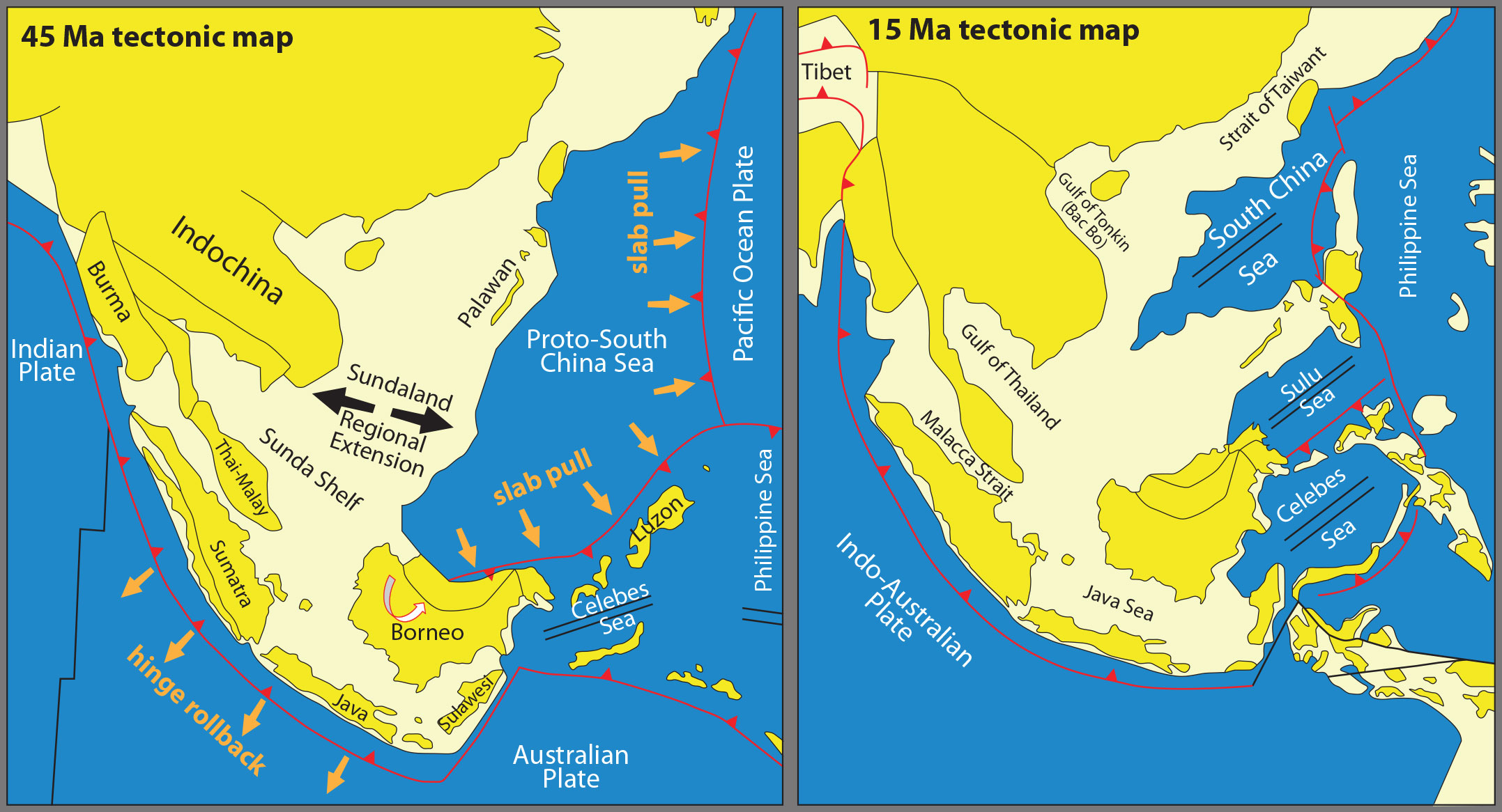
Another influential model for the opening of the SCS involves crustal extension in response to ocean-plate subduction on the western Pacific side. The initial idea for this model was given in the early 1980s by B. Taylor and D.E. Hayes (AGU Geophysical Monographs 27, part II) and has been developed by Robert Hall and his research group at Royal Holloway University of London.
This model considers the existence of a Proto-South China Sea during the Eocene which started subducting beneath the Pacific Ocean and the continental crust of Borneo. Crucial evidence for the Eocene-age Proto-South China Sea comes from the subduction complex and deepwater sediments of north-west Borneo (the Rajang-Crocker outcrops of Sarawak and Sabah). The pull of the eastward subducting slab is believed to have caused sufficient extension in the continental crust, which eventually led to the opening of a new oceanic basin – the SCS – during the Oligocene-Miocene.
While this model provides a reasonable framework for the origin of the SCS, geologists have also attempted to incorporate certain valid aspects of the India indentation model for an integrative scenario. For example, Ian Longley (1997, Geological Society of London Special Publication 126) has suggested that the widespread crustal extension of Sundaland in the Eocene was back-arc rifting induced by the Indian plate collision and contemporaneous oceanic subduction beneath the southern margin of Sundaland (Sunda arc). Tung-Yi Lee and Lawrence Lawver (1995, Tectonophysics, vol. 251) have argued that the extrusion of the Indochina Block induced the subduction of the pre-existing Proto-South China Sea, thus providing a mechanism for crustal extension in addition to the slab pull. Several geologists have extended the strike-slip faults of extrusion tectonics in the Indochina Block to major faults in north-western Borneo. For instance, Christopher Morley (2002, Tectonophysics, vol. 347) proposed a right-lateral transform system by linking the Red River Fault to the Lupar and West Baram Lines in Borneo, thus explaining the south-east movement of the Luconia carbonate platform from the Chinese margin in the north to the Borneo margin to the south.
Further enigmas
Any model for the genesis of the SCS should also explain the cessation of its seafloor spreading at about 16 Ma. This was probably due to major plate reorganisations in the region which shifted tectonic stresses. There is no consensus among geologists on this issue either. One possible case, as discussed by Charles Hutchison (2004, Marine and Petroleum Geology, vol. 21) and Andrew Cullen (2010, Petroleum Geoscience, vol. 160) is the regional uplift of Borneo and the convergence of the Dangerous Grounds with North West Borneo (the so-called Sabah orogeny along the North West Borneo Trough) in the Middle Miocene, and the coeval Sulu seafloor spreading.
Reasons for the protracted controversy on the origin of the SCS are manifold: the region contains a large number of tectonic blocks and structures about which we do not have sufficiently detailed information. The offshore extension of the onshore rock formations and structures is highly interpretive. Substantial uncertainties exist in the interpretation of palaeomagnetic data or the accuracy of geochronological data collected by obsolete techniques. And as data have been gathered piecemeal, they have revealed a more complex geologic history that any single model could account for.
And food for further thought: mantle plumes are known to last for tens of millions of years and trigger crustal rifting and the development of ocean basins as they impinge the tectonic plates moving over them. Some Chinese geologists have invoked the role of a mantle plume for the opening of the SCS. A case in point is the Hainan Plume beneath Hainan Island where lavas have outpoured since the Late Miocene, the bulk of them flood basalts in the past 3 million years. The rise of this mantle plume is believed to be associated with the deep subduction of the Pacific and Philippine Sea slabs in the east. If indeed a Hainan hotspot has been operative, its relationship to the nearby SCS remains to be investigated.


