Guyana, close to Western Suriname’s off shore boundaries, has steadily made headlines since 2015, delivering massive oil discoveries such as Payara, Liza, Tilapia, Haimara and even more recently Uaru. The gross recoverable resource for the Stabroek Block is now estimated to be more than eight billion oil equivalent barrels. If there seems to be no end to Guyana’s offshore success, the story so far for Suriname is pretty much just beginning. Although Suriname has some old onshore fields (Tambaredjo and Calcutta) from the 1960’s, the deep offshore part remains virtually unexplored. It was only a matter of time before Guyana’s oily ‘Golden Lane’ eventually spread Eastwards and reached Suriname with Total’s and Apache’s Block 58 Maka, Sapakara and Kwaskwasi discoveries in 2020.

Figure 1: Study setting with discoveries and Demerara Plateau. Bathymetry from Ryan et al (2009). © Clément Blaizot.
Chasing Guyana’s Hydrocarbon Success
Lying between Guyana and French Guiana, the prominent Demerara spur (Figure 1) also hosts some exciting oil and gas prospects, despite some recent disappointment from Tullow’s Block 47, Goliathberg-Voltzberg North prospect. In oil and gas exploration, as in many other aspects of life, success often follows early setbacks. This study focuses on the relatively abandoned deep offshore eastern part of Suriname where it is believed the recurrent oil seeps spotted on sea-surface from the old 1977–1978 wells, Demerara A2-1 westwards to the French Guiana 2-1 well eastwards, could predict future potential for the plateau. It highlights oil seeps detected on high coverage synthetic aperture radar (SAR) data, with more than 150 SAR images acquired at different dates within a 20-year timeframe. This time window offers a mean coverage of about 50 different images on every X and Y in the area of interest, which can be considered as a ‘comfortable’ coverage. Oil seeps have long been utilized in the exploration for oil and gas since the ‘visual detection’ of the Cantarell giant offshore oil field by Mexican fishermen in the 1970’s. They can be quite elusive, very much depending on the interpreter and their methodology and experience in discriminating natural oil seeps from pollution or lookalikes. Furthermore, the conclusions one may draw from seeps can sound controversial; finding numerous seeps does not identify where to drill – it ‘only’ suggests that there is a working local petroleum system – while finding no seeps does not mean the area is devoid of potential. When possible, an essential step to strengthen the seep interpretation, is correlation with seismic data so that the hints from ‘upstairs’ can be confirmed ‘downstairs’. Nevertheless, satellite seeps studies remain a formidable tool when used appropriately in conjunction with the retrieval of numerous SAR scenes at different dates. Very high data coverage, time recurrence (seeps persisting on different dates) coupled with spatial proximity (seeps concentrated in the same location) will help reduce uncertainty.
Geological Setting of Suriname’s Demerara Plateau
The passive margins of the Guiana Shield are located at the junction of the Central and Equatorial Atlantic rifting at a peculiar triple point between three continents: Africa, North America, and South America. Therefore, the region exhibits several different geological settings. Located at the center of the study area, the Demerara Plateau is composed of an enduring series from Precambrian to Miocene. Following the development of thick Jurassic basaltic flows (as seen in the French Guinana 2-1 well and present in Florida and Guinea), a thick Lower Cretaceous carbonate platform developed in the western part of the Demerara Plateau (Demerara A2-1 well) whereas sedimentation remained very lean eastwards. The western Demerara platform limit seems to be controlled by a SW-NE trending fault swarm (Figure 2) on its eastern edge and is then covered by thin Upper Cretaceous to Miocene sediments emphasizing the high topography of the plateau relative to its neighbouring basins to the west, north and east.
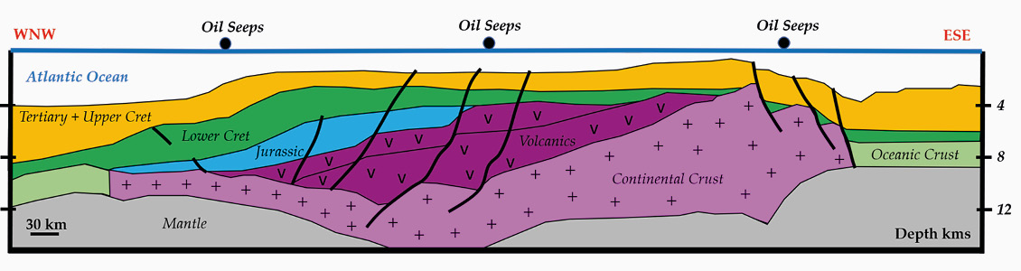
2: Cross-section sketch modified from Graindorge et al (2020) and Casson et al (2021).
To the west the Guyana/Suriname Basin resulted from the Central Atlantic SW-NE rifting in Lower-Middle Jurassic times. Because of the incipient rifting conditions, Jurassic deposits could therefore correspond to lacustrine and/or restricted marine source-rocks followed by massive turbiditic sandstones in the Cretaceous. These turbidites interfinger with potential open marine source-rocks of Albo-Cenomano-Turonian age called the Canje Formation. These turbiditic clastic sediments were deposited through the steep canyons at the mouth of the Berbice and Maroni paleo-rivers, eroding the Guiana Shield.
To the East lies the Foz de Amazonas Basin, a result of the north-west to south-east Equatorial Atlantic rifting and its separation from Africa in Albo-Aptian times. The first syn-rift deposits in this basin are linked to the erosion of the adjacent shields and comprise mainly large fan sands and shales at the toe of the abrupt normal faults. Here also, the Cenomano-Turonian could correspond to rich sources rocks as found in Deep Sea Drilling Project site 144 and Ocean Drilling Program site 1258C.
During the Tertiary, two major deltas expanded and two huge, associated deep-sea fans developed associated with the Orinoco to the west in the Guyana/Surinam Basin and the Amazon in the Foz de Amazonas Basin (Figure 3). These major sediment loadings are a key element for generating hydrocarbons from the rich Cretaceous Albian and Cenomanian source-rocks. Within and around the Demerara Plateau, the recurrent oil seeps observed by satellite seem to be linked to two major trends. Firstly, the internal south-west to north-east faults crossing the Demerara Plateau which limit the thick Lower to Upper Cretaceous depocenter to the west. Secondly, the outer north-west south-east major faults separating the Demerara Plateau from the Central Atlantic basins.
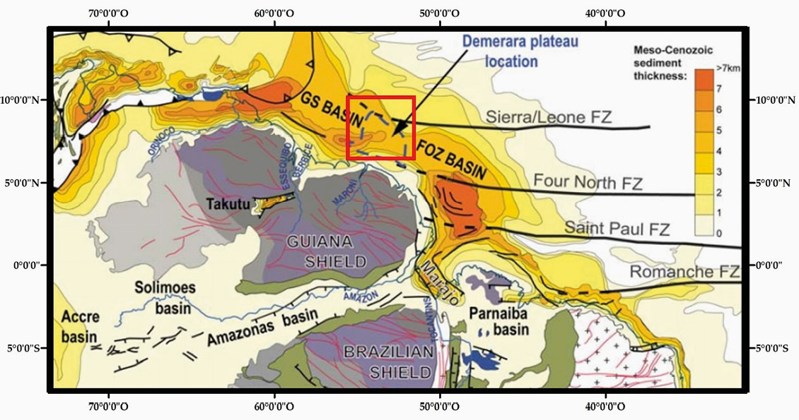
Figure 3: Tertiary Sediment Thickness from Loparev et al (2018). © Clément Blaizot.
Recurrence is Key
There are least three very promising repetitive seep anomalies (purple circles shown in Figure 4) extending from well A2-1 eastwards towards the flank of Demerara that could correspond to the termination of the oil migration conduits – the main sandy Cretaceous fairways connecting oil kitchens of Albo-Cenomano-Turonian age towards the edges of the basins (Figure 2).
Seep anomalies on Figure 4-a, 4-b and 4-c respectively display 9, 6 and 11 seepages spotted at different dates. Seeps here are both concentrated, superimposed and for some of them almost shaping an emission point, the so called ‘flower’ or ‘star’ structure that seep specialists are always eager to find.
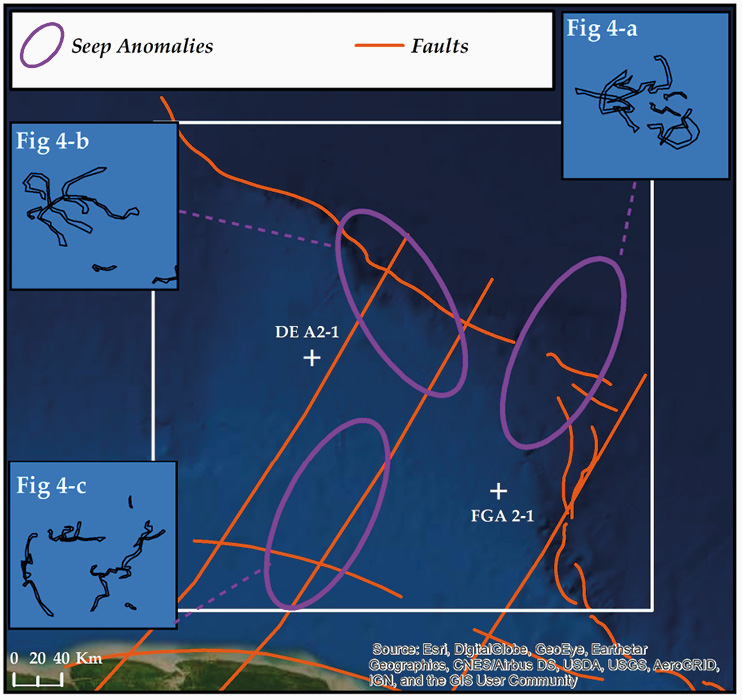
Figure 4: Oil Seeps anomalies in and around study zone. Faults modified from Casson et al. © Clément Blaizot.
Whilst seeps near mature fields can be used to seek field extensions, seeps are even better suited to exploration in frontier areas such as Demerara, where little other geological and geophysical data is available. Seep occurrences based on good SAR data coverage are often labelled ‘over-optimistic’, but it is simply arithmetic: the more satellite scenes you analyze, the more seeps you tend to find. However, it is important to note that the methodology used here aims at highlighting locations, not quantities. Seeps are often the initial evidence in the long exploration enquiry chain and are the first to be detected on the ‘geological crime scene’.
Notwithstanding, it should always be remembered that we are dwelling on clues, not evidences. We remain investigators, not coroners.
The principal complexity in seep interpretation is the discrimination between ‘natural oil seeps’ rising from the seafloor versus sea surface pollution (spills/ship discharges). Within and around Demerara, more than 100 potential natural seeps have been observed. Confidence in them is high, regarding both their characteristic morphologies and signatures (Figure 5). As sea surface oil pollution and spills are relatively low in this area, the very significant number of seeps around Demerara adds weight to the conclusion that these are natural in origin.
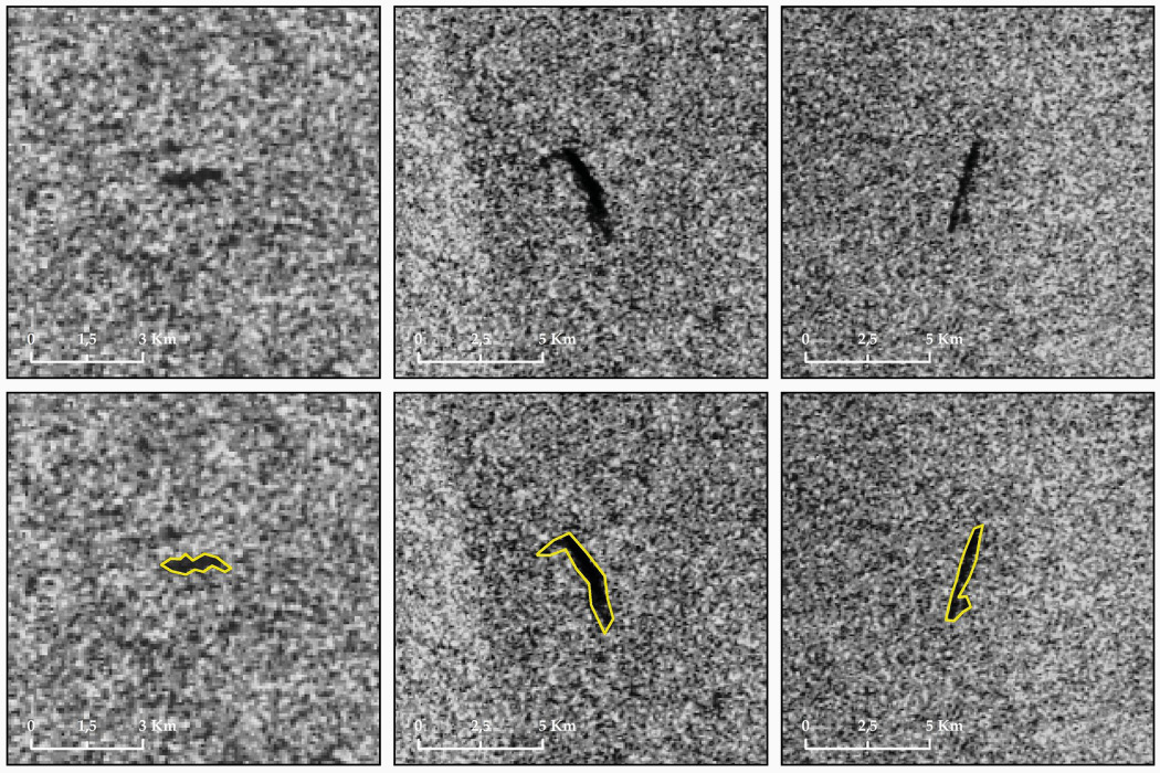
Figure 5: SAR illustrations of spotted potential oil seeps and vectorized in yellow. © Clément Blaizot.
Venturing in the Unknown
The iconic novel by Alan Sillitoe, ‘The Loneliness of the Long-Distance Runner’ perfectly mirrors the challenges ahead for future oil and gas exploration. As a frontier explorationist, you might feel the loneliness of chasing evasive, long-term, ‘against all odds’ rewards rather than the more plentiful short-term targets.
Undoubtedly, as time passes, fewer unexplored basins remain. At these uncertain crossroads, the lengthy and hazardous frontier path might possibly lead you into either a dead-end or into a lively beginning. Oil seeps provide a genuine helping-hand and Demerara has proved once again the usefulness of SAR seeps studies by mingling several key elements: a large dataset, high data coverage, spatial proximity, seep recurrence along with manual interpretation and ‘blind’ interpretation (do not chase the seeps exactly where the geology would tell you to look for or where you might want to find them).
As SAR satellite data becomes more widely accessible, accurate, real-time, and retrievable at any time, there is little doubt about its future role in the exploration cycle. More than ever, oil seeps stand as a ‘fair way’ to unveil the fairways.
References
Casson, M., Jeremiah, J., Calvès, G., De Ville de Goyet, F., Reuber, K., et al. 2021. Evaluating the segmented postrift stratigraphic architecture of the Guyanas continental margin. Petroleum Geoscience, Geological Society.
Graindorge, D., Basile, C., Heuret, A., Klingelhoefer, F., Loncke, L., Roest, W.R., Sapin, F., 2020. Le plateau de Démérara et ses marges au large des Guyanes. Géologues numéro 206.
Loparev A., Rouby, D., Chardon, D., Ye, J., Bajolet, F., et al. 2018. Sediment routing systems of cratonic domains to their margins from accumulation histories and continental paleogeography at geological timescales: the Equatorial Atlantic margins of the West African and Guyana Shields. European Geosciences Union General Assembly 2018, Apr. 2018, Vienne, Austria. Geophysical Research Abstracts.
Ryan, W.B.F., S.M. Carbotte, J. Coplan, S. O’Hara, A. Melkonian, R. Arko, R.A. Weissel, V. Ferrini, A. Goodwillie, F. Nitsche, J. Bonczkowski, and R. Zemsky. 2009. Global Multi-Resolution Topography (GMRT) synthesis data set, Geochem. Geophys. Geosyst.


