A casualty of the slowdown in demand for hydrocarbons has been the upstream geophysical industry. However, is it possible that exploration methods developed to meet the needs of the global hydrocarbon industry can be repurposed for application to seabed minerals?
Seabed mineral deposits
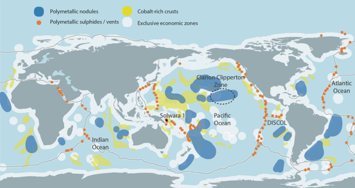
Oceanic mineral deposits come in three basic flavours and are found throughout the world’s ocean basins (Figure 1). Firstly, massive seabed sulphides (Figure 2a) which are associated with active and relict mid-oceanic ridge hydrothermal systems. These deposits are rich in copper, cobalt, zinc and other metals, and occur in water depths between 1 and 4 kms. Although other metallic deposits exist on the ocean floor, massive seabed sulphides receive the most press and in the public eye have become synonymous with seabed mining in general. This is firstly, because nearly all current exploration efforts have been focused on these deposits, and secondly, the protection of the unique biospheres which surround active ridge vents are of great concern to environmentalists. Two-thirds of the world’s mid-ocean ridges are in international waters.
The second are seabed nodules (Figure 2b). Large areas of mainly tropical ocean seafloors are known to have accumulated these tennis-ballsized polymetallic nodules which have a high concentration of key metallic elements. The accretion process is both extremely slow (millions of years) and poorly understood, with nodules confined to waters between 4 and 6 kms in depth in areas such as the eastern Pacific and the Indian Ocean.
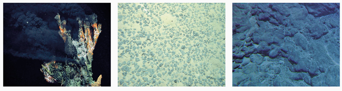
Lastly, there are the metallic crusts (Figure 2c) which are found mainly on the flanks of seamounts, in depth ranges similar to those for seabed nodules and are of great interest, because of their high concentration of manganese and cobalt. These seamounts are mostly found within the Economic Exclusion Zone of smaller island nations.
Seabed mineral exploration
It would be reasonable to expect the seabed mining industry to follow commercial stages similar to the oil and gas industry, starting with reconnaissance exploration. Especially with many of the regions that could be explored extending over hundreds of thousands of square kilometres, it will be necessary to efficiently identify the sweet spots where mining activities could be focused. It will also be critical to identify the regions of specific environmental sensitivity where seabed mining activities might be limited or banned.
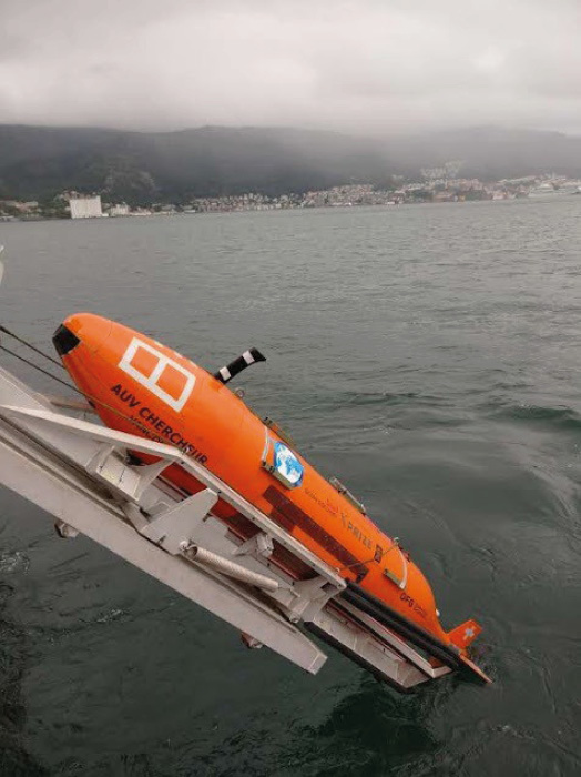
The next phase would include detailed mapping and monitoring. Mining engineers will need to know the grade of the ore deposits and their lateral and vertical distribution. Engineers will also need to understand the mechanical properties of the near surface, as well as other local parameters such as ocean currents, as these factors will impact the method(s) used for mining. Most of the smallscale commercial activities associated with seabed mining to date, have focused on this stage. Many have made use of Autonomous Underwater Vehicle (AUV) technology (Figure 3).
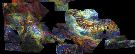
An AUV can be equipped with a range of sensors that can collect a rich multiphysics dataset in a single dive. The resulting interpretation (Figure 4) combines acoustic, electric, magnetic and geochemical information to characterise a sulphide deposit both in terms of its seafloor expression, and hidden subsurface structure. Finally, as deposits are mined and depleted, mining sites will need to be decommissioned in an environmentally responsible fashion.
The seismic industry seeks green pastures
As is obvious to all working in the oil and gas industry, a combination of depressed oil-price driven by oversupply and a reduction in demand exacerbated by the Covid-19 pandemic, has severely impacted the upstream business. The global seismic vessel fleet has reduced by approximately 80% over the past five years, with companies ceasing to trade, and others either exiting the marine seismic acquisition market and/or significantly reducing their vessel numbers. However, oil prices have risen recently and have stabilised around $60 bbl for Brent crude, and with travel restrictions expected to ease over the coming months as the pandemic is brought under control, we might expect a recovery in this sector as we enter a new cycle. However, the parallel rise in concern over climate change has forever changed the nature of the oil industry and we are now seeing an inexorable longer-term decline in oil consumption as the world transitions to greener energy alternatives.
Given all of this, it comes as no surprise that upstream seismic industry players are keen to investigate new and greener markets. The model shown in Figure 4, was created from data acquired from a single seven-hour dive using a variety of AUV sensors. However, when considering reconnaissance-style surveying of large areas of the seafloor, AUV and/or nodal surveys may be too slow and too expensive. Surveys that deploy seafloor instrumentation may also be penalised on environmental grounds. This leads to towed-sensor methods as a viable method for surveying large areas efficiently and cost-effectively.

The seismic industry has developed sophisticated and scalable towed systems for the exploration and exploitation of oil field reservoirs. Can this technology be redeployed for seabed mining applications, with reference to the initial reconnaissance phase? To answer this question, we need to consider the needs of the seabed mining industry and to compare this to the world of oil and gas. Oil and gas reservoirs often lie several kilometres beneath the seabed and to exploit these reserves, petroleum geoscientists are interested in a range of earth properties such as structure and stratigraphy, lithology (mineralogy, porosity and permeability) and fluid type and saturation.
Compare this with seabed mining, where deposits will be located either at the seafloor, or only a few tens of metres below. Mining engineers will be interested in bathymetry, near-surface geology, presence, and concentration of metallic (conductive) ores, near-surface mechanical properties and related properties such as water chemistry and ocean floor currents. With this in mind, it is possible to sketch out in broad terms, the oil field data acquisition and processing technology that could be repurposed to meet the needs of a global seabed mining industry.
Data Acquisition
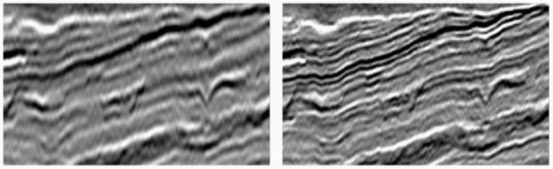
It will be necessary to image the seafloor geometry (bathymetry), and the geology a few hundred metres beneath the seafloor, in water depths between 1 and 6 kms. High resolution is key, with the ability to identify surface features with a resolution of 20m or better. Recent advances in towed-streamer acquisition geometries, such as the use of wide-towed sources and variable multisensor streamer geometries, can provide data suitable for high-resolution imaging of the shallow subsurface. (Figure 5).
For onshore mining applications, electromagnetic (EM) and magnetic measurements are the geophysical tools of choice for identifying and quantifying ore bodies, and so it will be for offshore deposits. There are already existing methods available for acquiring shallow and deep-towed controlled source electromagnetics (CSEM) data which could be deployed to meet the needs of seabed mining. Ideally the seismic and CSEM data would be acquired simultaneously, using the same surface vessel or vessels.
The maritime industry is well on the way to developing a range of next generation vehicles offering unmanned, autonomous, and semi-autonomous operation, together with the application of novel propulsion systems based on hydrogen fuel cells and/or electric motive power. Such vessels will offer a much lower cost and environmental footprint than existing fleets, as well as being capable of operating continuously at sea for months at a time.
Data processing and interpretation
The oil and gas industry has developed sophisticated processing and interpretation algorithms and workflows which could be easily adapted and pivoted into the marine seabed mining market. These include wavefield imaging methods for generating high-resolution seafloor and near-surface images to yield bathymetry and shallow structure and stratigraphy. Multiphysics integration of seismic and CSEM data can quantify the distribution of metallic elements in the near surface. Rock-physics advances, driven by interest in shale plays and unconsolidated sediments,
can be used to convert geophysical attributes to mechanical properties of specific interest to mining engineers. Machine learning (ML) and artificial intelligence techniques (AI), applied to ‘big data’ can also be utilised for seabed mineral exploration. As we accumulate larger and richer datasets, it should be possible to use AI/ML approaches to mine both structured and unstructured data to help identify areas of economic and environmental interest. The real promise of these approaches is that the more data acquired, the more robust such predictions become.
Fit for purpose
It is important that geophysicists demonstrate to engineers as early as possible the value of the information and knowledge we can acquire. Within the oil field sector, drilling and reservoir engineers use geophysical data sparingly, and it has been seen already in more mature markets for industries such as wind farm development, that geophysical methods play only a limited role as a complement to geotechnical measurements. In the oil industry, the challenge for geophysicists to meet the need of engineers can be summed up in three statements: too expensive, too slow, and engineers need properties with uncertainties defined in depth, not geophysical attributes in time. So, for geophysics to be relevant in new markets, they need to focus not just on the acquisition technology but understand the need to complement more traditional and well-established geotechnical measurements by being competitive in terms of cost, time, robustness and relevance of information.
The most profitable components, indeed perhaps the only truly profitable components, of the upstream oil and gas seismic industry have been associated with multi-client business models where data is acquired once and re-sold to multiple parties over multiple years. Often these datasets are supplemented with new data and/ or new processing and interpretation methods, further extending the return on the initial investment in data acquisition. A question to be answered is whether similar business models will become available to geophysical providers to the seabed mining industry.
Seabed mining is not yet an industry; it might be better described as a nascent industry, with a variety of government and commercial organisations around the world working to understand and develop the technical and commercial environment to support the possible development of seabed mining. Development of deep-sea mineral mining technology is underway, though the water depths involved present significant challenges. Environmental concerns are significant and must also be addressed before seabed mineral resources can be responsibly utilised. Geophysical technology, modified for studying the shallow subsurface and deployed from efficient autonomous platforms has the potential to provide information to make robust environmental decisions and to guide responsible exploitation of seafloor mineral resources.