
After decades of primitive pre-industrial oil production, the first cycle of successful oil exploration in Russia took place in the foothills of the Greater Caucasus at the end of the 19th century, initially focused on natural oil and gas seeps in the area (Figure 1A).
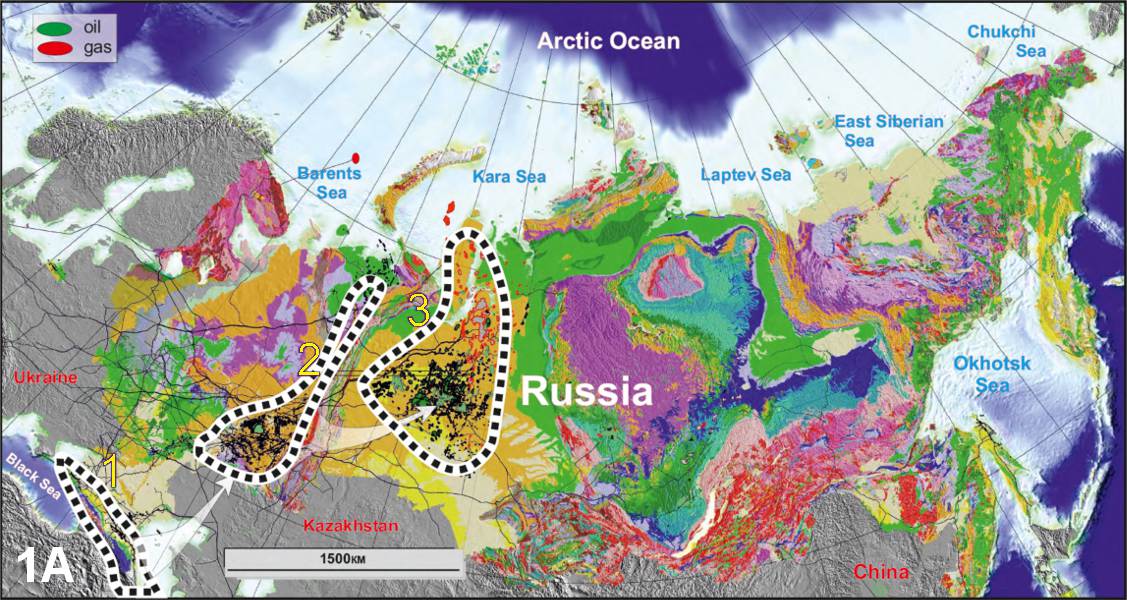
Figure 1A: Geological map of Russia showing distribution of oil and gas fields, with focuses of petroleum exploration outlined: 1 – Caucasus; 2 – Uralian foreland; 3 – West Siberia.
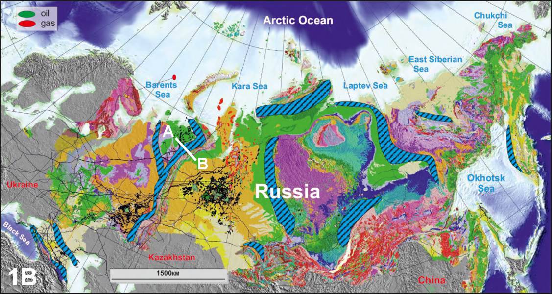
Figure 1B: Geological map of Russia showing distribution oil and gas fields, with the location of the most important onshore fold-andthrust belts prospective for oil and gas outlined. Line A-B is approximate location of the section shown in Figure 4B.
The First Two Cycles
 ‘Cover Story’. This article first appeared as the lead story in Vol. 12. No. 3 of our magazine. To subscribe to the magazine please use the button in the menu at the top of this page.Eventually, with the development of the anticlinal theory, exploration efforts spread beyond the areas of natural seeps, and the young fold belt of the Caucasus provided numerous outcrops unveiling different geological settings. The principal plays were related to Tertiary sands sealed by alternating shales, with pays down to two kilometres, limited by available drilling capabilities. Figure 2 shows a cross-section through the Oktyabrskoye field in the foredeep of the Caucasus, discovered in 1913, where several oil pools were found in the Miocene deposits in a high-relief anticline, exposed at the surface. Elsewhere, step-out drilling discovered the presence of other trap types, such as pinch-out traps and channelised sands, but these were rare and could not be predicted outside well studied areas. By the mid-1930s, after several decades of successful exploration, the stack of drillable prospects drastically reduced and exploration efficiency dropped.
Several sedimentary basins were studied in order to offset the decline in the Caucasus, culminating in success in the Uralian foreland in the late 1930s. Early discoveries related to shallow Permian reefs were made through traditional geological mapping, but the Uralian foredeep area is primarily flat and outcrops were not as widespread as in the Caucasian foothills. Agricultural lands, steppes and forests cover much of the area, making surface mapping useless, so structural drilling emerged as an important exploration tool. The predominantly conformal bedding of the sedimentary fill meant that drilling shallow wells helped to map closures at these levels, which could be projected to deeper prospective structures in Devonian-Carboniferous strata. This technique was rapidly found to be successful and was widely implemented. Low risk deep drilling and quick learning led to a string of significant discoveries, while centralised planning helped disseminate technological solutions, accelerating reserve build-up.
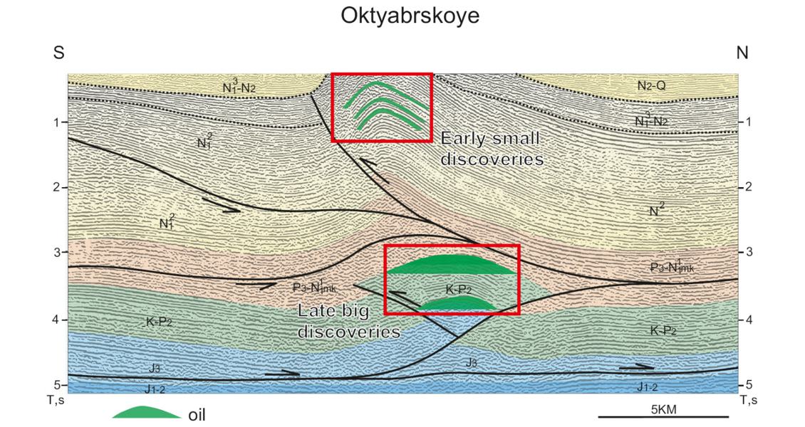
Figure 2: Interpreted seismic line across the Oktyabrskoye oil field. Upper red box shows oil deposits discovered in 1913, lower box is the much bigger oil pools discovered in the 1960s. (Data courtesy RosNedra)
The large potential of the Uralian foreland resulted from favourable conditions for petroleum generation and accumulation, including the world-class mature Domanik (Upper Frasnian) source rocks, and the large areal extent of the basin, exceeding 1 million km2.
The rapid growth in production fuelled the industrial development of the USSR in the 1950–1960s. However, by the 1960s many of the drillable closures had been tested and the success rate dropped, repeating the previous cycle.
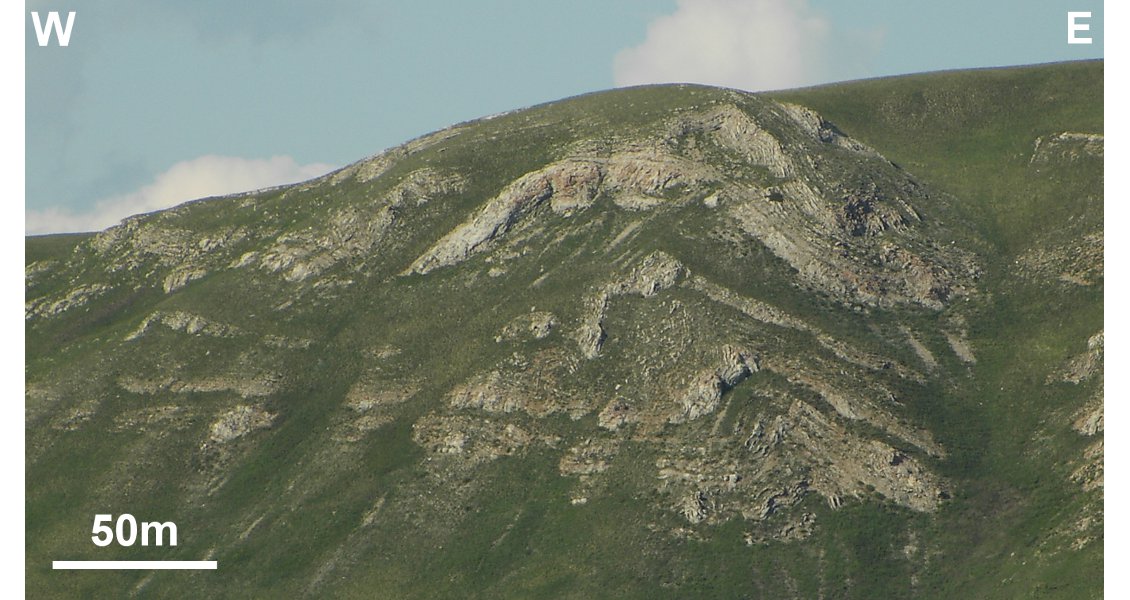
Figure 3: West-verging thrust-related fold in Lower Permian carbonates, Kruzhevnaya Mountain, Southern Bashkiria, Southern Urals. (Source: Konstantin Sobornov)
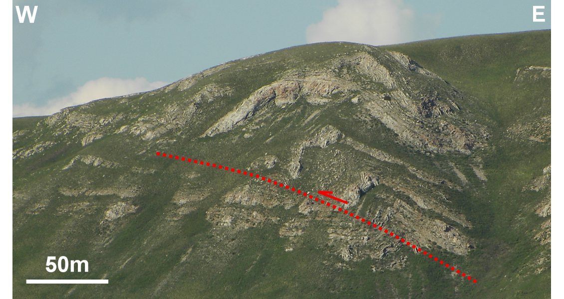
Figure 3: West-verging thrust-related fold in Lower Permian carbonates, Kruzhevnaya Mountain, Southern Bashkiria, Southern Urals. (Source: Konstantin Sobornov)
Third Cycle: West Siberia
Initially, petroleum prospecting in West Siberia caused serious skepticism. The geology of the basin had little in common with known producing basins, confusing many Soviet oilmen. No shows of thermogenic hydrocarbons were reported and much of the region was covered with swamps, making surface mapping and structural drilling useless. In the early days exploration efforts were focused on the western pre- Uralian margin of the basin, which lacked mature source rocks. Finally, thanks to the enthusiasm of the explorers, after several failures a discovery was made in 1961 in the Middle Ob area, heartland of the West Siberian Basin, which attracted serious attention from an oil industry desperate for new prolific plays capable of replacing the fading fortunes of the Volga Urals. Subsequent studies showed the presence of a unique, super-prolific petroleum system. Resources were relocated from the mature Volga Urals to West Siberia to ensure a continuity of reserve build-up in line with ambitious Soviet economic plans.
At this time seismic surveying started to play a leading role in prospect definition. Thanks to the relatively simple platformal geological setting and favourable seismogeological conditions of the West Siberian lowlands, seismic prospecting quickly demonstrated its enormous value. Huge areas were covered with data and a large number of drillable prospects identified. Subsequent drilling exceeded the most optimistic expectations, resulting in the discovery of the second most important petroleum basin in the world. Massive field development and infrastructure construction projects topped the list of national economic priorities as oil and gas revenues started to provide a large part of GNP.
The West Siberia exploration cycle generally replicated the Uralian foreland one but at a greater scale; prospective areas in West Siberia exceeded 3 million km2. Oil and gas reserve additions rapidly ramped up in the 1960s and 1970s, although exploration efficiency peeked in the mid-70s. Since then, the creaming curve has inevitably flattened out. Recently, the use of modern exploration techniques such as 3D seismic helped to find significant new reserves but failed to arrest the decline in the overall exploration performance, mainly because the size of new fields tended to get smaller.
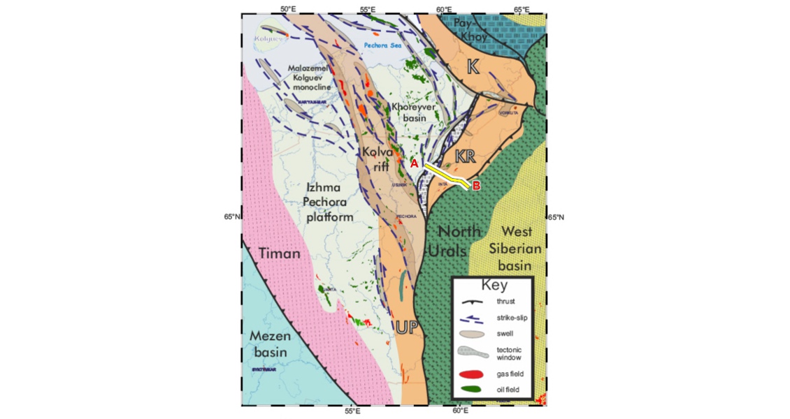
Figure 4A: Regional geological map across the Polar Urals fold-and-thrust belt (location of section shown in Figure 4B illustrated). Initials correspond to pre-Uralian foredeeps. (Data courtesy RosNedra)
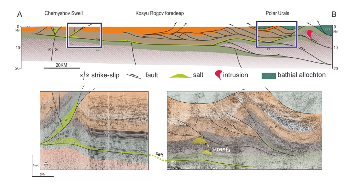
Figure 4B: Regional geological section across the Polar Urals fold-and-thrust belt (for location of section see Figure 4A). Insets: interpreted seismic lines. (Data courtesy RosNedra)
No More Easy Discoveries
The decreasing efficiency of petroleum exploration in the mature West Siberia stimulated studies of other basins, including the Precaspian, Central Asia, offshore Caspian, East Siberia, Far East, northern Timan Pechora and Arctic shelves. This resulted in several huge finds, but failed to offset the gradual decline in exploration success in West Siberia. Geological conditions and the technology of the time did not permit the replicable discoveries of the Volga Urals and West Siberia. In addition, the remoteness and predominance of gas made many new projects marginally economical.
Big subsalt finds in the Precaspian Basin, for example, were followed by a number of dry holes. Complexities relating to depth conversion of seismic data in areas of salt diapirism routinely resulted in significant mistakes in subsalt mapping. Arctic drilling yielded predominantly gas discoveries, such as the Stokman and Rusanovskoye fields – difficult and expensive to develop. Big deposits in East Siberia, such as the Yurubchen field, were too remote, and the Precambrian reservoirs were discontinuous and often tight. Overall, plays were either not as prolific as expected, or the technologies were inadequate for the subsurface and above ground complexities – all coupled with unstable market conditions in the late 1980s and early 90s. The disintegration of the USSR left attempts to find reserves replacements unfinished. The era of easy and cheap new discoveries was gone.
Over the last 20 years the Russian oil industry has undergone a period of restructuring and privatisation. Economic conditions made the new Russian oil companies focus on optimising production. Investments in the aging development facilities and infrastructure, as well as adoption of the best international reservoir management technologies, helped to increase recovery factors and created a brownfield renaissance. Newly available technologies, such as 3D seismic, were primarily used for development of the existing fields and near-field exploration. The huge Soviet legacy provided sufficient reserves to boost growing production and as a result exploration activities were drastically reduced.
It seems that this period is now over. Production from the aging giants is getting more expensive, while existing producing fields have predominantly hard-to-recover reserves with a high water cut. The identification of new exploration plays to replace older fields is therefore a priority issue.
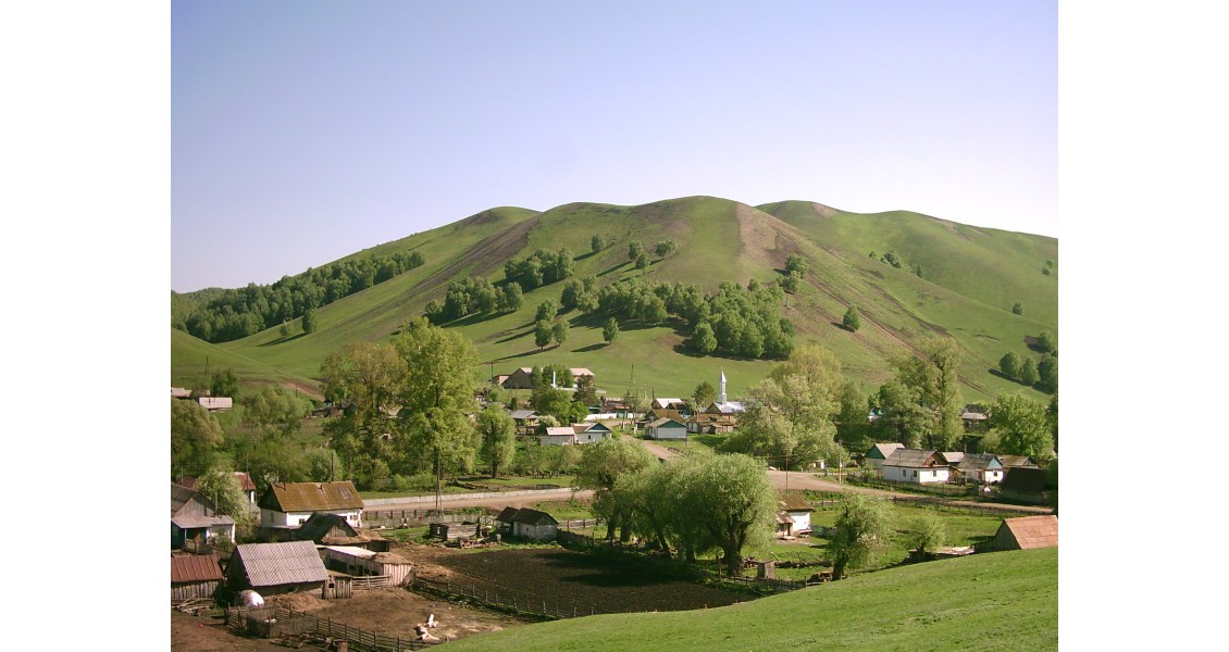
Figure 5A: Village in the Southern Uralian foothills, Bashkiria. (Source: Konstantin Sobornov)
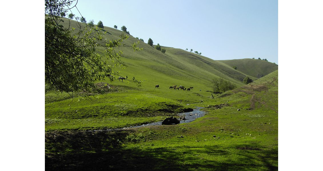
Figure 5B: South Uralian foothills, Southern Bashkiria. (Source: Konstantin Sobornov)
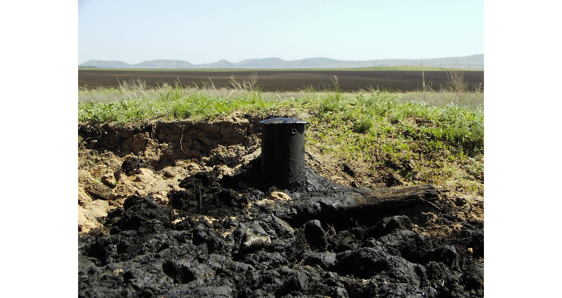
Figure 5C: Oil-seeping from abandoned well drilled in 1950’s in the foothills of the South Urals, Orenburg. (Source: Konstantin Sobornov)
The Arctic and Shale Resources
Examination of G&G data characterising the petroleum potential of Russia indicates that this task may have several possible solutions. The most popular options include exploration in the Arctic shelves and the realisation of the potential of shale deposits.
The Russian Arctic offshore has a total area of more than 4 million km2, and despite significant discrepancies in resource estimates there is huge exploration potential. Global warming has extended the ice-free period, allowing longer navigation and operations. Previous exploration and newly available data clearly indicate the presence of large prospects and leads, so geological risks seem to be acceptable. However, Arctic projects require stable, high oil prices, and the technical and ecological challenges of petroleum exploration and production in the area are huge. In addition, it is thought that a significant amount of the hydrocarbons are gas, a less economically attractive prospect than oil.
Shale development could be a very attractive option. The estimated potential is huge; the lowest estimate of leading Russian experts is about 150 Bbo (20 Bn tonnes). Attempts to make tight rock work started decades ago; even subsurface nuclear explosions were made to increase tight reservoir performance, but with little success. Several shale projects are underway, mainly in West Siberia, with some good results. Wider development of shale is limited by taxation of oil production and the high cost of horizontal drilling and fracking, complicated by the swampy surface conditions of West Siberia. Currently, shale production is feasible in mature areas of West Siberia and Volga Urals, as secondary production objectives.
Fold Belts – a New Alternative?
However, significant new exploration potential is thought to exist beyond these two alternatives. A critical review of G&G data shows that high impact opportunities exist in areas of complex geology, mainly represented by fold belts, which are found flanking virtually all sedimentary basins in Russia (Figure 1B).
Due to limited data it is difficult to estimate total areal extend of the prospective lands, but preliminary estimates suggest up to 2 million km2 onshore. The fold belts are of different types and ages ranging from Late Precambrian to Late Tertiary. Some prospective fold belts are completely buried; in West Siberia folded Palaeozoic deposits host some significant oil and gas fields underneath gently deformed Mesozoic cover. Generally, fold belts have thicker sedimentary sections involving more reservoir-seal pairs compared to the adjacent platformal areas, along with thicker organic-rich marine shales producing huge volumes of hydrocarbons. Many fold belts have oil and gas shows indicative of the presence of working petroleum systems. Multiphase structuration provides diversity of trap types including highrelief closures capable of delivering large flow rates. Fold belts often involve reef systems which were developed within continental margins prior to onset of compressional folding, and the buried reefs along with drapes and talus deposits may host vast volumes of hydrocarbons. Under favourable conditions the fold belts may have extremely high reserve densities, as exemplified by giant fields in Iran, Iraq and Venezuela.
Ironically, the oil industry originated in fold belts, but after picking the low-hanging fruits these areas were left behind. Exploration tools were not good enough to provide data on the subsurface to support risky drilling of poorly constrained prospects. Moreover, with the finding of low-risk opportunities in the Volga Urals and West Siberia, the complex terrains dropped low on the list of exploration priorities, reflecting limited geological knowledge rather than hydrocarbon potential.
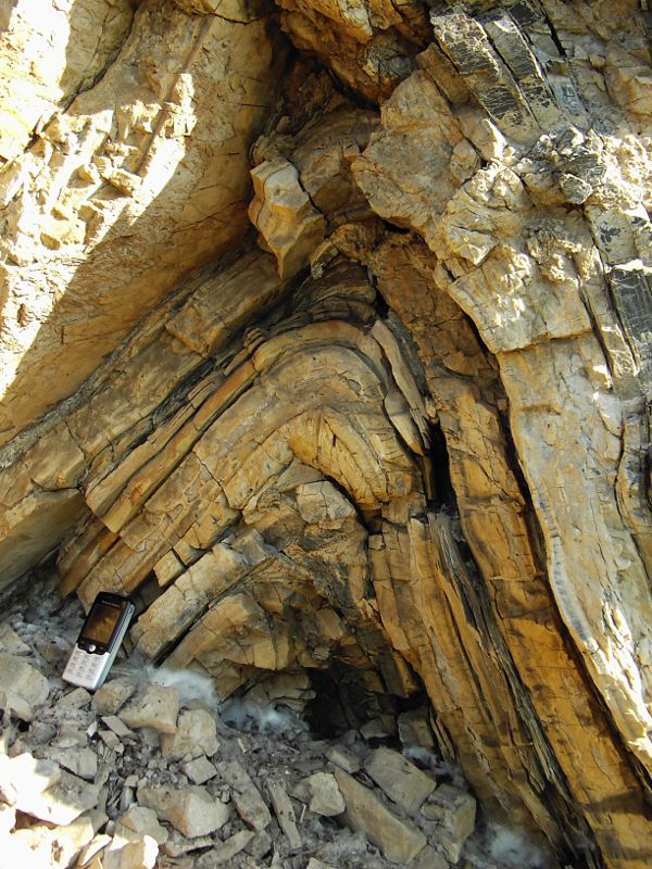 Figure 6: Isoclinal fold in the Upper Devonian basinal carbonates- shales-chert alteration (flysch) of the Zilair nappe (overthrusting deep water deposits, overlying platformal sedimentary cover of the East European craton), Southern Bashkiria. (Source: Konstantin Sobornov)There are examples of important discoveries made in fold belts decades after the first exploration cycle. Large oil pools in Cretaceous carbonates were found at greater depths at the Oktyabrskoye field in 1960s (Figure 2). Note that the crest of the Cretaceous closure does not coincide with the Miocene anticline exposed at the surface. This structural pattern involves detachment faulting and tectonic wedging providing disharmonic folding. The thickness variations of a weak tectonostratigraphic interval masked the shift of the deeper closure. The discrepancy in the crest locations explains why the deeper Cretaceous closure hosting much greater oil deposits was bypassed by wells drilled within the Miocene anticline. Discoveries of this type could be made in most cases through seismic surveying, which was introduced well after the first exploration campaign. This case shows that the rule ‘big fields are first to be discovered’ does not work in fold belts.
Recent regional studies show that complex structural settings providing significant new exploration opportunities are attributable to many fold belts. The diversity of large mainly untested leads in fold belts is illustrated by a regional geological and supporting seismic line across the Polar Urals foldand- thrust belt (Figure 4B). Of prime interest in this area are high-relief 4-dip closures and reefs.
There are many other fold belts where leveraging advanced exploration technologies could reveal new prospective plays. Currently 3D seismic surveying provides the most reliable data for the prospect generation in complex geological terrains, but the best results could be delivered through the integration of various exploration methods including electromagnetic and geochemical studies, potential field data, remote sensing and field observation. Crucial for successful exploration in fold belts are expertise in structural geology, drilling technology, overpressure prediction and hydrocarbon modelling.
Some fold belts like the Caucasus and Urals are situated in areas with well-developed infrastructure and significant local consumption, where even small discoveries could be economical. Taking into account the size of prospective areas in the fold belts, it seems reasonable to suggest that the fold belts could deliver a new cycle of oil and gas exploration in Russia.


