The Black Sea: Something different?
Black SeaSPAN data highlight unusual geometries that do not correspond to established general models of continental separation, leading to new ideas about the opening of the Black Sea. A range of potential hydrocarbon traps are revealed, including tilted fault blocks, stratigraphic traps and folds related to both gravitational and deep-seated tectonics.
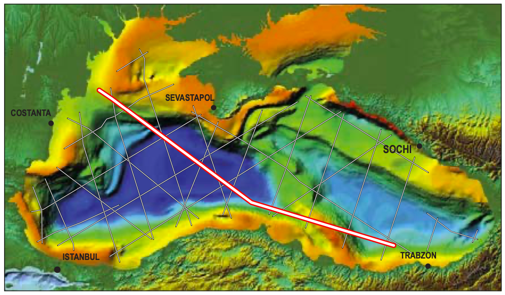
The Black Sea comprises two distinct back-arc basins lying between the Eurasian continent and the accretionary collage of Anatolia. The western basin is mid-Cretaceous in age and the eastern one is late Cretaceous to Paleocene. The basins are separated by central en-echelon ridges – Arkangelski and Andrussov – which together form the Mid Black Sea High. With the exception of the north-west where the undeformed Russian Platform bounds the western Black Sea, both basins are surrounded by Tertiary fold-and-thrust belts (the Crimea, the Great Caucasus, the Pontides, and the Balkanides). In the north-east, the rift shoulder of the eastern Black Sea Basin forms a major submarine high, the Shatsky Ridge, which lies between the basin proper and the Tuapse Trough (the foreland basin of the Western Caucasus). The Eastern Pontides are essentially a volcanic arc. Interpretations derived from seismic data, gravity modelling and water depth all suggest the central parts of both the western Black Sea and the eastern Black Sea are small ocean basins (Bellusov et al., 1988; Finetti et al., 1988; and Görür, 1988).

Cretaceous strata are assumed to directly overlie oceanic crust, as rifting and ocean crust formation are interpreted to have occurred during this period. The lithology of the Cretaceous in the deep basins is unknown, but carbonate build-ups seem to exist on tilted fault blocks on the marginal parts of the continents. The ‘tramline’ Tertiary sequence which overlies the Cretaceous is shale prone with a likelihood of submarine channels and basin floor fans derived from the basin margins. The best chance for reservoir-quality sandstones in these sequences lies outboard of the Don, Dnieper and Danube palaeo-rivers. The highest risk for reservoir presence is in the southern and south- western parts of the western Black Sea Basin and everywhere in the eastern Black Sea.
Prospectivity
Today the Black Sea is a restricted anoxic basin that is likely to generate vast volumes of hydrocarbons in the geological future. Although it is located in an extremely oil-rich part of the world (within the play-fairway area of the Oligo-Miocene Maykop Formation, the world class source of oil for the Caucasus and the Caspian), the prospectivity of the Black Sea Basin is poorly known. The Maykop is almost certainly oil-mature beneath its 10 km thick blanket of basinal Neogene sediments, and mud volcanoes (right) testify to active fluid migration and significant overpressure. In addition to the Maykop, three separate Cretaceous horizons as well as Palaeozoic coals have been identified as source rocks (Görür, 1997).
Potential reservoirs include Cretaceous syn-rift clastics analogous to those known onshore in the Pontides, as well as Neogene channels and submarine fans and Jurassic and Cretaceous carbonate build-ups. Trapping potential exists in carbonate builds-ups, tilted fault blocks, a range of stratigraphic traps, gravitational structures and in the frontal structures of fold and thrust belts of the Tuapse trough offshore Crimea and the eastern Black Sea.
In spite of these possibilities, the Black Sea basins have not delivered anything like their theoretical potential, which a relatively conservative estimate would put at more than 10 Bbo.

Deep structure
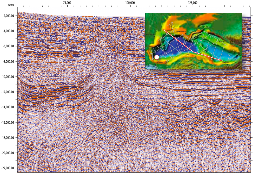
ION Geophysical’s Black SeaSPAN data provide unique images of the deep structure of the continental margins of the earth, but given the fact that we are looking 20, 30, or in some cases 40 km into the earth’s lithosphere, it almost goes without saying that our ability to interpret the data relies partly on direct knowledge, and to a large extent on models. Using observations from ION data globally, the empirical analogue base is growing, but the Black Sea data set challenges existing models and may be something not seen elsewhere.
Ideally we recognise two types of passive margins – volcanic margins where spreading is fast, allowing decompression melting and the production of volcanic melt, and non-volcanic margins where spreading (and continental separation) is slow and there is no significant volcanism or underplating. Volcanic margins are characterised by seaward dipping reflectors (SDRs) that commonly develop between the continental edge and the true oceanic crust.
At non-volcanic margins continental separation is by faulting and ductile shear. Oceanic crust and associated spreading post-date the separation of the continents, and sub-continental mantle is ‘dragged out’ from beneath the continents to be exposed in the outer marginal zone (trough) between the continental edge and the ocean crust proper.
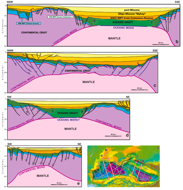
There are no clear SDRs or obvious exhumed mantle visible on the Black SeaSPAN data. The oceanic crust predicted by earlier works is obvious from the seismic character and thickness, but there are no magnetic stripes in the Black Sea to corroborate this interpretation. Both the continental and oceanic Moho are recognisable on the data. The continental Moho can be seen rising towards the oceanic areas, but it is unclear exactly how the continent gives way to the oceanic crust, as the reflectors of the ocean crust are more or less continuous with reflectors which onlap the continental edge. The map on page 61 shows the limits of oceanic crust and continental crust (red and blue lines).
The area between them is presumably where the mantle has been exhumed and buried by volcanic or sedimentary sequences. How much of this material is volcanic and how much is sediment is uncertain. As we noted, the reflectors are not unequivocal SDRs and they seem to merge with oceanic crust sensu stricto. In the eastern Black Sea Basin there is virtually no transition zone and the transition from continental to oceanic crust is extremely abrupt.
New observations
The western Black Sea is traditionally thought to have opened behind a continental fragment, the Istanbul Zone, which drifted south between two transforms – the West Black Sea fault and the West Crimean fault. The north-east to south- west trending lines in the south-western Black Sea show a strike slip fault and the inverted margin of Crimea is almost certainly oblique, but there is no indication of any transform on the lines through the centre of the western Black Sea Basin. Hyper-stretched continental crust in the south-western and south-eastern parts of the basin gives way to oceanic crust in the basin centre, implying a more complex opening pattern than previously thought. It seems that the western basin is comparable with the eastern Black Sea where stretched continental crust in the north-west gives way to oceanic crust south-eastwards (Shillington et al., 2008). Future exploration will show whether the Black Sea basins are as commercially attractive as they are tectonically fascinating.


