
Kwanza shelf potential petroleum systems
The Kwanza Shelf is situated within the Kwanza Basin, located in the southern part of the West African Aptian salt basin. The depocentre began to develop through rifting of the proto-Atlantic in the Late Jurassic to Early Cretaceous and represents the conjugate margin to the prolific hydrocarbon-bearing Santos and Campos Basins, offshore Brazil. The petroleum systems offshore Angola can be characterised in relation to the tectonic history of the margin.
The pre-/syn-rift was dominated by an extensional tectonic phase forming a series of horst and grabens perpendicular to the coastline where mixed continental facies were deposited. This included the deposition of the main syn-rift/pre-salt source rock: the Barremian- aged Bucomazi Formation. Three main reservoir units occur within the syn-rift/pre-salt sequence: the pre-rift Lucula Formation alluvial sandstones, the syn-rift Red Cuvo Formation alluvial sandstones, and the Grey Cuvo Formation (Chela Formation equivalent) fluvial to lacustrine sandstones and limestones.
The post-rift is characterised by a shift from restricted evaporitic facies to open marine deposition and contains four main reservoir units: Albian Pinda Formation shelf carbonates; Late Cretaceous Iabe Formation progradational shallow marine sandstones; Palaeocene/Eocene Landana Formation sandstones; and Oligocene/Miocene Quifangondo Formation sandstones.
Exploration history: The overlooked Kwanza shelf
Of a total of 43 wells drilled on the Kwanza Shelf, 31 wells were drilled prior to 1993. Exploration moved to deeper water targets during the early 2000s following the rush to find analogues to the super-giant Lula oil field discovered in the Santos Basin, Brazil.
On the shelf, only two exploration wells have been drilled using early 1990s 3D seismic, with the remainder using 2D data of various 1980s vintages. Despite the limitations associated with mapping features using regional 2D seismic, drilling success rates have been encouragingly high. Between 1983 and 1990, of the seven wells drilled in shallow water, five made oil discoveries which were developed into the Cegonha, Mubafo, Denden, Pakubalu and Muamba fields.
These accumulations proved that both pre- and post- salt plays extend from the onshore to offshore, further helping to de-risk the prospectivity of the Kwanza Shelf. The Mucua-1 well led to the discovery of the Denden field and proved the pre-salt play. Aptian pre-salt carbonate reservoirs formed in a lacustrine environment range from microbialites and oolites to coquinas, with primary porosities up to 15% and secondary macro-scale porosity enhancement due to dolomitisation.
Enhanced 3D broadband imaging to reveal potential
Improved imaging of the Aptian Loeme Formation salt is vital in unlocking the future prospectivity of the underexplored Kwanza Shelf area, and a detailed velocity model is key to revealing the intricate geometries associated with the salt. For this, tomography (reflection and refraction) and Full Waveform Inversion (FWI) have been used to unveil the complex structure associated with halokinesis while addressing the challenges in the imaging at the pre-salt interval. Figure 1 (foldout image) shows the significant imaging gains and the impact on seismic inversion products. The pre-salt is better imaged compared with vintage 2D time data and the sharpening of pre-salt fault planes allows a more accurate interpretation of the basin controlling syn-rift tectonics.
Improved 3D Broadband Quantitative Interpretation to Highlight Prospective Areas Quantitative Interpretation analysis has been performed over the entire section (post-salt and pre-salt) using conditioned partial angle stacks. For the seismic conditioning, a Reservoir Oriented Processing (ResOP) workflow was performed using four angle stacks.
The processing sequence included de-noise, spectral harmonisation, and time misalignment correction. Thereafter, intercept and gradient attributes were estimated and integrated through the Prospect Scanner workflow to derive elastic attributes such as relative Acoustic Impedance and relative Vp/Vs. Attributes were calibrated to available well data ensuring a consistency between well and seismic data. Seismic responses that could not be associated to in-situ well response, were further analysed using the available interactive rock physics atlas (PGS rockAVO), via perturbation in real time of porosity, fluid and saturation over each reservoir interval.
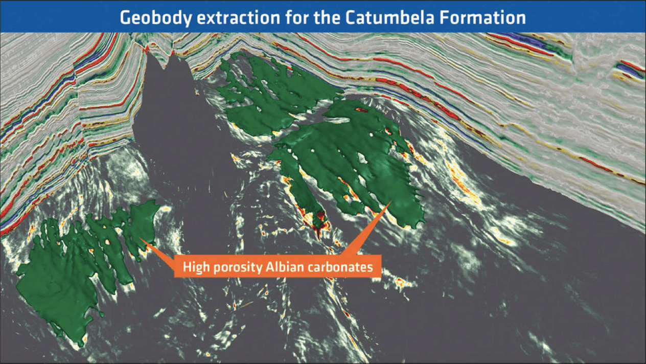
The post-salt Albian play, proven in the Cegonha and Mubafo fields, highlights a working petroleum system with reservoirs in post-rift fluvio-deltaic sandstones and shallow marine carbonates. The Albian Tuenza and Catumbela Formations show excellent reservoir potential with porosities ranging from 20 to 25% within the shelfal area, as evidenced by wells drilled in the vicinity. A total porosity seismic volume calibrated to well data has been used to confidently map high-porosity carbonates over the Kwanza Shelf (Figure 2).
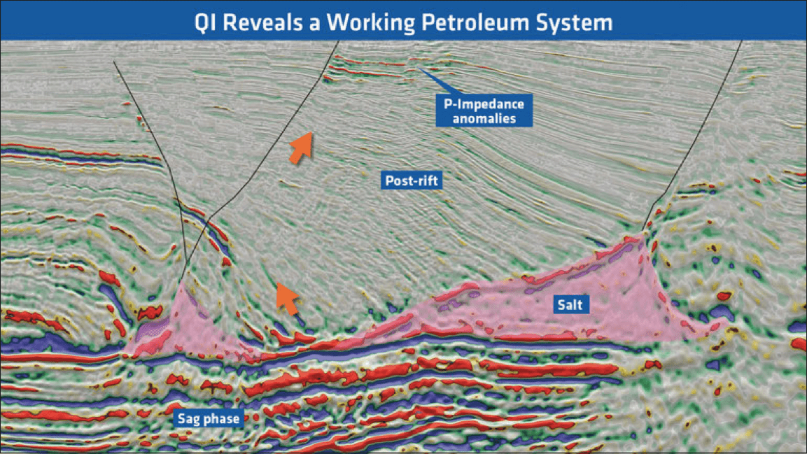
Multiple direct hydrocarbon indicators (DHIs) can be identified within channelised stacked sandstone deposits in the post-rift section. Tertiary turbidite facies on the Kwanza Shelf are analogous to the prolific gas and oil-bearing turbidites found to the north in the Lower Congo Basin. Porosity in these sandstone deposits is estimated to be in the range of 26–30%, with permeabilities above 400 mD. Two main structural configurations can provide a pathway for hydrocarbons generated from syn-rift source rocks to migrate into these younger deposits. The first occurs in areas where complete salt withdrawal results in mini-basin salt welds. The second is found in areas where faults caused by halokinesis extend through the post-rift section and terminate at the top of the syn-rift (Figure 3).
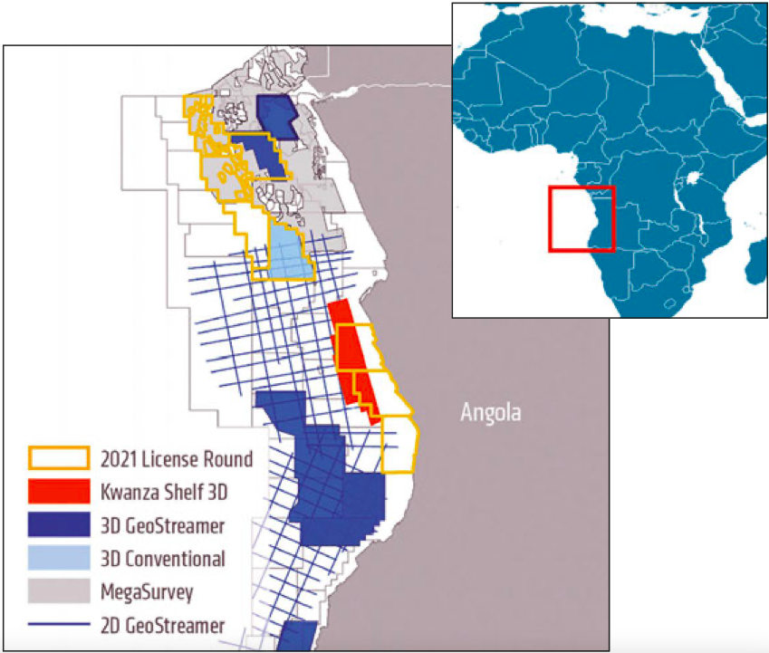
Opportunities Revealed by GeoStreamer Dataset for Offshore Angola 2021 Licence Round
The new GeoStreamer seismic dataset over the shallow- water Kwanza Shelf provides exceptional 3D imaging of both pre- and post-salt sequences in the area. The new seismic data, in conjunction with an interactive rock physics atlas, allows for a fully integrated quantitative seismic data interpretation workflow which reveals opportunities across the underexplored Kwanza Shelf area. The insights gained from this study demonstrate how important new data is for unlocking the prospectivity of the area for the upcoming Angolan 2021 licence round.


