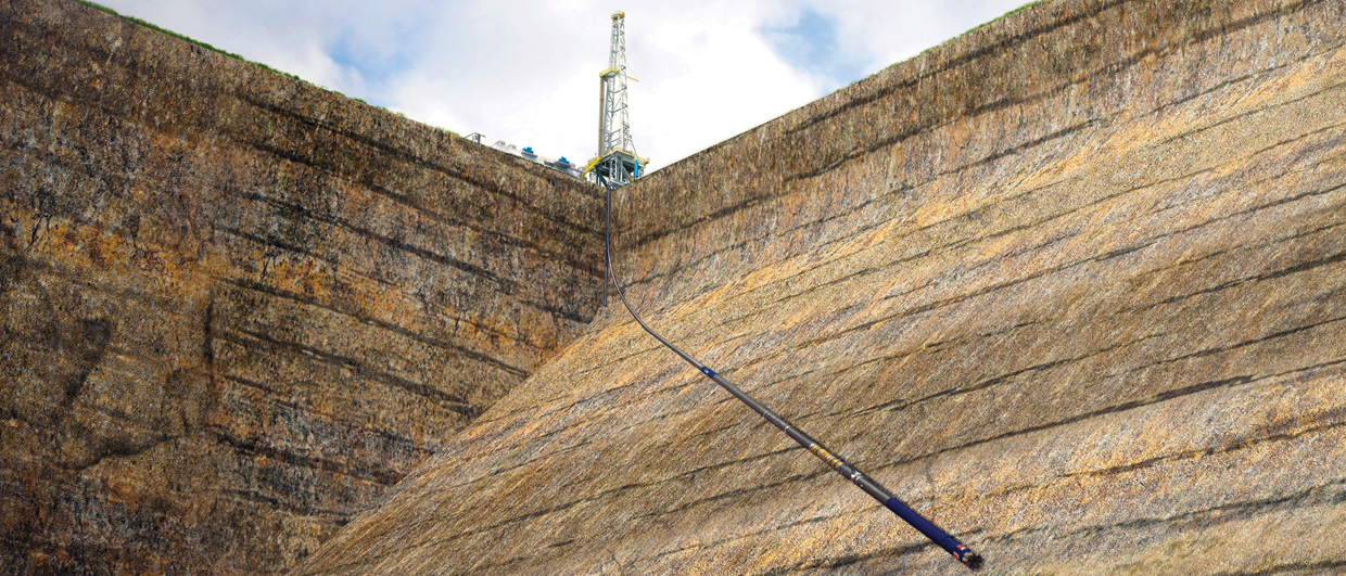
Directional drilling presents a number of formation evaluation challenges, however. In HaHz wells it is often difficult to apply the traditional petrophysical interpretation techniques used in vertical wells, particularly the resistivity logs, due to geometric effects on the data. A well is said to be horizontal if it deviates more than 80° from vertical (Passey et al., 2005). Modern technologies allow standard petrophysical measurements to be acquired under these conditions, such as coil tubing and drill pipe assisted logging, and the development of LWD tools and assemblies which have become the primary means of acquiring logging data in HaHz wells.
The difficulty begins with the fact that LWD data acquisition strategies in horizontal wells are often designed for geosteering purposes and can be unsuitable for petrophysical evaluation. Even when full LWD logging suites are available in HaHz wells it is often difficult to apply vertical well petrophysical interpretation techniques because of bed boundary effects and proximity to uncrossed layers, local layering or resistivity anisotropy, and polarisation horns on the resistivity measurements (Griffiths et al., 2012). Other effects complicating the borehole environment include asymmetric invasion profiles, the presence of cuttings beds and drilling mud segregation (Passey et al., 2005). Many operators therefore now find themselves in the situation of being able to land HaHz wells inside a challenging target in the desired stratigraphic position, but less able to interpret the acquired logs to obtain a correct petrophysical evaluation of the well data.
Many operators therefore now find themselves in the situation of being able to land HaHz wells inside a challenging target in the desired stratigraphic position, but less able to interpret the acquired logs to obtain a correct petrophysical evaluation of the well data.
A Digital Solution
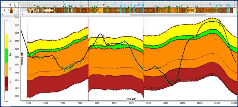
It is possible, however, to improve the LWD data prior to analysis using modern E&P software. A recent project outlined how the most common effects in horizontal wells can be addressed using a new workflow within the Techlog wellbore software platform, from Schlumberger (Valdisturlo et al., 2013). The project focused on wells in a developmental field in North America. The reservoir consisted of a few tens of feet of thick, silty sand beds, interbedded with siltstone and local alignments of carbonate concretions, deposited in a shelfal environment. Extended reach wells used in the development of the field had long lateral sections: between 5 and 10,000 ft (1.5m–3.5 km). Due to the geological complexity of the area, the wells often crossed multiple layers and faults and were actively steered to optimise reservoir contact. The workflow was applied on two complex horizontal wells to improve delineation of the formation properties and aid standard petrophysical evaluation. The workflow built a layered geological model which simulated log responses in a continuously updated loop to obtain corrected physical properties for each layer, taking into account the influence of nearby layers on the log response.
The workflow checks LWD logs and compares them with existing vertical wells to assess reliability. Sections from the geological model are then used to build the formation model in the proximity of the well. If available, LWD image logs are also used to calculate formation dip and azimuth along the trajectory. The formation model is then verified, refined, and updated. Each layer of the formation model crossed by the well is populated with formation properties based on selected well logs. For layers not crossed by the well, properties are manually entered based on offset well responses. If necessary, lateral property boundaries are inserted in the layers, allowing for property variations to exist in a layer which the well intersects more than once. Forward model simulations of the logs are then compared with the measured logs, and the layered model and layer properties are manually refined until the best agreement between simulated and acquired logs is reached.
Validated layer properties from the workflow form the basis for the new petrophysical evaluation, which is compared with the original evaluation performed using raw acquired data. Substantial differences are evaluated and understood, before final validation and updating of the geological model. Lastly, a final hydrocarbon-in-place calculation update is performed.
Analysis-Ready Data
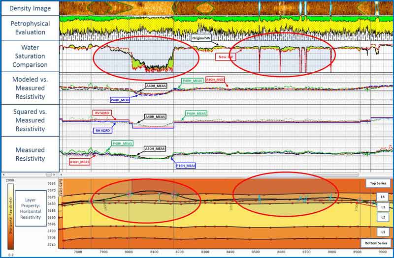
In one of the wells, where it crossed three thin layers at a high angle, extended shoulder bed effects are
observed. The resistivity measurements responded to the multiple layers within their volume of investigation, causing the measured resistivities to read higher than they would in a single layer. Consequently the standard interpretation would deliver a water saturation which was too low. By accounting for these shoulder bed effects, the new interpretation delivered higher and more precise water saturation in the thin shaly beds, avoiding undeliverable hydrocarbon volume in a substantial non-reservoir section. In this interval the effect of the carbonate-cemented concretions was clearly observable on the density image.
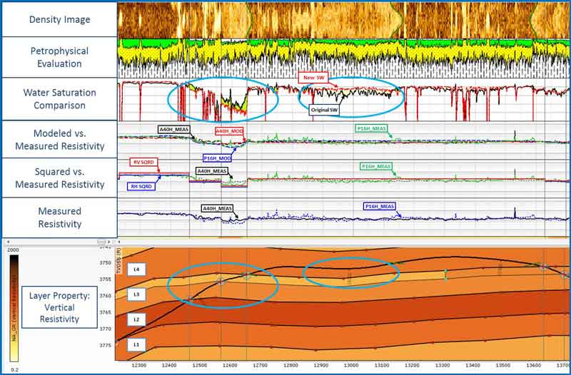
The effect of extended bed boundaries and an associated blurring of the resistivity response were evident. The use of the layer properties and a fine geological model sharpened the bed boundaries, and took them, and the surrounding layer resistivities, into account when the resistivity fast forward model was computed. Use of the geometry-corrected layer resistivity in the petrophysical analysis indicated water saturation of almost 100% in the shale (as expected in this area) and revealed higher hydrocarbon saturation in the layer near the exit and entry points. This resulted in improved water saturation determination.
Optimised Analysis
Although bringing a number of significant benefits, the increasing prevalence of HaHz wells has highlighted some of the limitations of traditional petrophysical interpretation techniques in these wells, due to geometric effects on the data. This challenge calls for new approaches and modelling workflows to improve the reliability of interpretation results. Digital drilling and interpretation technologies will form part of a wider theme to be discussed at the 2014 SIS Global Forum, in Barcelona on April 15–17. This biennial industry conference will focus on the future of digitally mitigating E&P risk, using simulation and software technology.
The workflow in the above project efficiently confirmed and refined the geological environment from the static reservoir model, and provided true formation layer properties for use in the petrophysical analysis. The comparison of log responses between vertical and deviated wells was helpful for quality control, and in the well log modelling phase to assess the correct record of petrophysical properties for the input logs and the model ling results. Log measurements were updated and a resulting improvement in petrophysical answers was observed.


