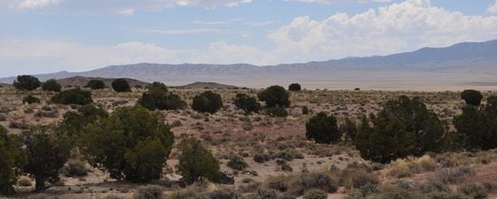
The Great Basin of Utah and Nevada in south-western USA is a vast, arid landscape with hot summers and snowy winters. Its tectonic framework, a Basin-and-Range extension formed during Neogene times, was superimposed on Palaeozoic-Mesozoic sedimentary rocks. These Palaeozoic marine shales and clay-rich carbonates offer a new frontier for the shale oil and gas revolution in North America. Indeed, the Palaeozoic tectonic history of the Great Basin parallels that of the US east coast, where the Marcellus Shale has been a target of intense exploration and production.

Simplified map of the Great Basin of Nevada and Utah showing the major oil fields and oil shows (modified from Oil Fields of the Great Basin, Nevada Petroleum Society, 1994). The Great Basin is bounded by the Antler orogen (Roberts Mountain Thrust) and Sonoma orogen (Golconda Thrust) on the west, and the Sevier orogenic belt (the Rockies) on the east. These compressional structures are east-verging and formed prior to the Basin-and-Range extension. (Sources: National Atlas of the United States and Rasoul Sorkhabi)
A drive on interstate highway I-15 in Utah is immensely scenic, largely because the road runs north-south between two distinct geological provinces: the Colorado Plateau on the east and the Great Basin Desert on the west. The latter, with an area of about 360,000 km2, occupies the western half of Utah, almost all of Nevada, and the eastern fringe of California. It is actually part of the much larger Basin-and-Range province, which represents a region of crustal stretching and thinning since the Miocene, as the continental crust under south-west USA and Mexico underwent extensional tectonics.
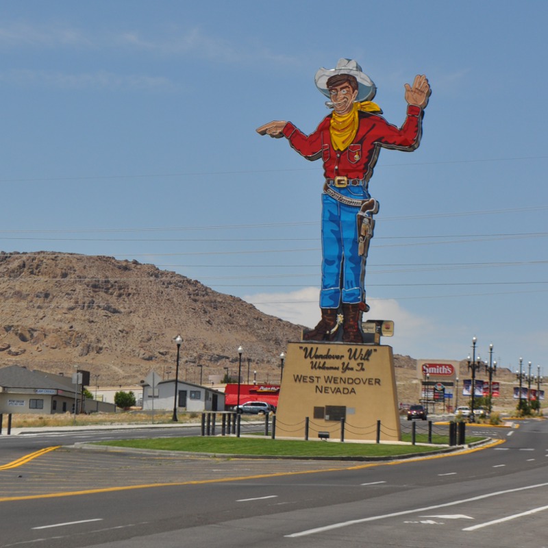 West Wendover in Nevada, a town in the Great Basin. (Source: Rasoul Sorkhabi)The crust under the Great Basin is about 25 km thick (compared to the 40–50 km crust of the Colorado Plateau and Rocky Mountains to the east); it has low Bouguer gravity values (-150 to -250 mgals) and high heat flow (mostly 92 mW m-2). This high thermal anomaly is due to the injection of large volumes of Eocene-Pleistocene igneous rocks into the thinned continental crust, making the region favourable for geothermal resource development. Indeed, Nevada and Utah are (after California) the second and third largest producers of geothermal electricity in the USA. Hydrothermal solutions and veins associated with igneous bodies and carbonaceous sedimentary rocks have produced important mineral deposits, including copper, silver, gold and gemstones. Due to its arid climate, the Great Basin is also famous for saline lakes and rock salt deposits.
The Basin-and-Range province is marked by a series of north-south trending valleys (basins) bounded by rugged mountains formed along high-angle normal faults (rift-shoulder uplifts), which curve to low-angle listric (‘spoon-shaped’) faults at depth, before flattening to merge to a major detachment fault at the base. The exposure of rocks on the footwall of the normal faults and the arid climate of the Great Basin provide geologists with an excellent opportunity to study the rocks present deep in the valleys.
The width of the Basin-and-Range province increases from about 325 km at 36°N to about 680 km at 40°N. Studies show that the minimum amount of crustal extension in the southern Great Basin is about 140 km (Geology, October 1982, pp. 499-502) and the amount of crustal extension in the northern part no more than 188 ±43 km (Earth and Planetary Science Letters, 1985, v. 75, pp. 93-100).
The Basin-and-Range landscape was superimposed on the Palaeozoic- Mesozoic rocks that underlie the region – it is these older rocks that are the focus of this article.
History of Exploration
Oil seeps in the Great Basin were observed in the early 1900s at Rozel Point on the east side of the Great Salt Lake; in 1979 Amoco’s West Rozel well found ultra-heavy oil in fractured Pliocene volcanic rocks in the area.
In 1892, Utah’s first gas field, Farmington, was discovered north of Salt Lake City. In 1907, the Virgin field in south-west Utah was discovered, with oil (22–32° API) coming from Triassic sandstone; the field was abandoned in the 1970s. Also in 1907, the first well (dry) in Nevada was drilled south-west of Reno. From the 1900s to 1954, about 90 wells were drilled in the Great Basin, mostly close to oil seeps, but with no success.
In 1954, Shell discovered the Eagle Springs field in Railroad Valley, Nye County, Nevada. This was followed by the discovery of Trap Spring (1976), Currant (1978), Bacon Flat (1981), Grant Canyon (1983), Kate Spring (1986), Duckwater Creek (1990) and Sans Spring (1993), thus establishing Railroad Valley on the US oil map. In 1982, Amoco discovered the Blackburn field in Pine Valley, Eureka County, Nevada, north of Railroad Valley, followed by the discovery of three other fields in Pine Valley: Tomera Ranch (1987), North Willow Creek (1989), and Three Bar (1989). Railroad Valley and Pine Valley are currently Nevada’s only oil-producing areas. Production peaked at 4.01 MMbo in 1990, slipping to only 313,000 barrels in 2014.
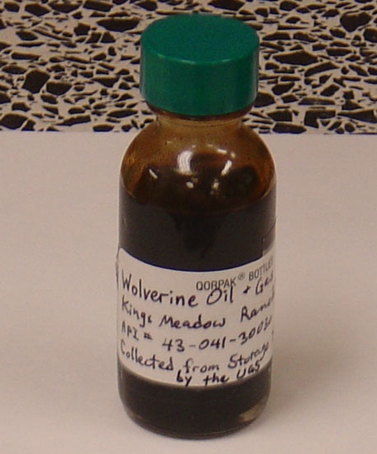 Light sweet crude from Covenant oil field in central Utah produced from the Jurassic Navajo Sandstone was charged from the Mississippian shale deep in the basin. The field was discovered by Wolverine Oil & Gas Corp. in 2003.In 2012, US Oil and Gas drilled Eblana-1 well into the Hot Creek Valley prospect, Nye County, Nevada (about 20 km to the west of Railroad Valley) and hit oil (28.5–33° API) in the Oligocene- Miocene, volcanic-sedimentary reservoirs at depths of 1,944 to 2,210m, in a prospect block bounded by normal faults. In 2013, Nobel Energy announced the drilling of several wells into the Oligocene-age Indian Well and Elko Shale formations in northeast Nevada and described the wells penetrating the Elko Shale as having ‘initial encouraging results.’ If the Elko Shale is to be developed, it will require hydraulic fracturing. In both Hot Creek Valley and Elko, deeper wells will also penetrate the Palaeozoic sediments.
Overall, Cenozoic plays, notably the Eocene Sheep Pass Limestone and the Oligocene-age volcanic sediments of Garret Ranch Group and Indian Well Formation, have been widely targeted for oil exploration and production in Nevada.
In Utah, the Upper Valley field was drilled in 1964, and the Anderson Junction field in 1968. After the 1973 oil shock, Utah’s Great Basin attracted some exploration but wells drilled into the Cenozoic sediments filling the faulted valleys were not encouraging. Utah’s most recent conventional oil discoveries are the Covenant field (2003) and Providence field (2008), both located on the Central Utah fold-and-thrust belt, which is a continuation of the Sevier belt extending to Wyoming and Montana (see ‘Central Utah Thrust Belt: Tectonics of a New Exploration Province,’ GEO ExPro, Vol. 3, No. 4).
Back to the Palaeozoic
The Palaeozoic Appalachian Basin of eastern USA is a classic oil and gas province; it is home to the Devonian age Marcellus Shale, one of the top shale plays in the world. The Palaeozoic rocks of the Great Basin, covered by Cenozoic sediments, have, however, received little attention, but a comparison of the Palaeozoic geological histories of eastern and western USA reveals remarkable tectonic and stratigraphic similarities. Both regions began as passive-margin continental platforms of North America during the Cambrian, and were later subjected to compressional tectonics as continental blocks collided with both sides of North America during the Palaeozoic. In the east coast, from Alabama to New York, a series of collisional events culminated in the Appalachian Mountains and associated foreland basins during Permian times as African collided with North America.
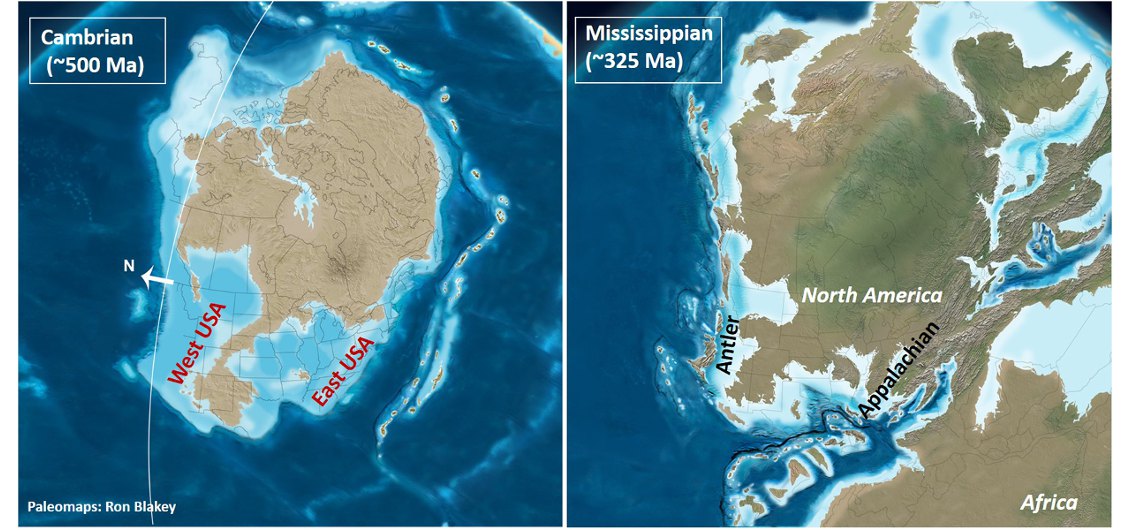
Palaeotectonic maps of North America during the Cambrian and Mississippian periods depicting tectonostratigraphic parallelism between east and west USA. (Source: Ron Blakey, Northern Arizona University)
On the western margin, following the subduction of the ocean floor, a major island arc collided with North America; this tectonic event, called the Antler orogeny by R. J. Roberts in 1951 after Antler Peak in Nevada, spanned Late Devonian-Mississippian times. The Roberts Mountain thrust fault in central Nevada is the remarkable feature of this tectonic collision. During Permian-Triassic times, in what is called the Sonoma orogeny, another island arc collided along the Golconda Thrust in western Nevada. Later, the Pacific-side ocean floor began to subduct beneath the North American continent creating the Sierra Nevada (consisting mainly of igneous rocks derived from ocean-floor subduction) and the Sevier fold-and-thrust belt (the Rockies and their foreland basins) that extends from Canadian Alberta to Utah.
The Palaeozoic rock package of the Great Basin may be divided into (1) Cambrian-Middle Devonian passive continental margin (carbonate platform), (2) Late Devonian Early Mississippian Antler sequence (mainly dolomite, limestone and shale) ending with the uplift of the Roberts Mountains and deposition of Chainman shale in a foreland basin to the east of the mountain range; and (3) Pennsylvanian-Permian carbonate sediments deposited during a regional subsidence.
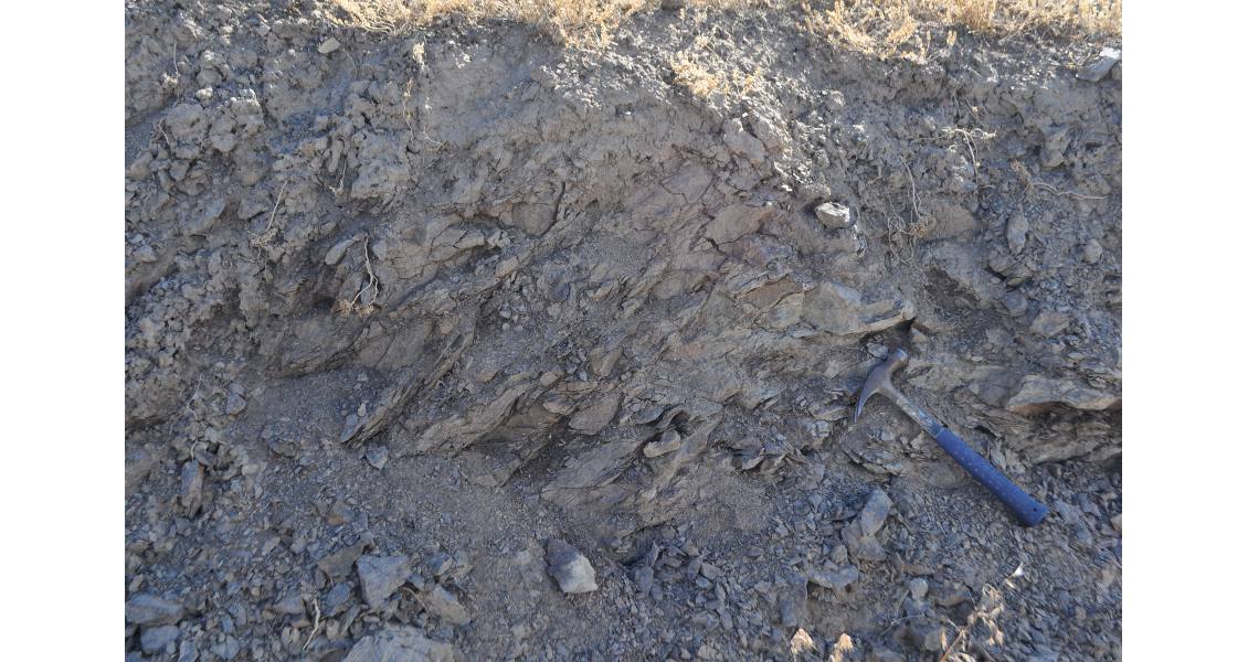
The Mississippian-age Chainman Shale is believed to be a prolific source rock in the Great Basin of Nevada and Utah. (Source: Rasoul Sorkhabi)
Future Prospects
A 2007 report by the US Geological Survey estimated that about 1.6 Bbo and 1.8 Tcfg remains to be discovered in the Great Basin (US Geological Survey Digital Data Series DDS-69-L). This resource evaluation was only for conventional oil and gas in the Neogene basins and fold-and-thrust belts. The unconventional resources (shale and other tight reservoirs) underlying the Mesozoic-Cenozoic have been relatively less explored.
There are already some encouraging signs for the Palaeozoic plays. In Utah, oil in the Upper Valley field was produced from the Permian-age Kaibab Limestone (17° API) and in the Anderson Junction field from the Pennsylvanian-age Callville Limestone (27° API). Although the reservoir rock in the Covenant and Providence fields in central Utah is the Jurassic-age Navajo Sandstone (API over 40°), the source rock charging this reservoir is widely thought to be the Mississippian Chainman Shale deep in the basin. In Nevada, the Devonian Guilmette Formation (brecciated dolomite) has yielded oil (25–28° API) in the Grant Canyon and Bacon Flat fields in Railroad Valley.
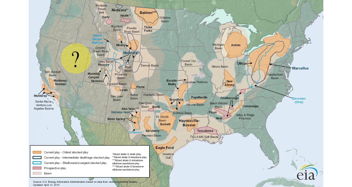
US Energy Information Administration’s map of the major shale gas plays in the lower 48 United States. The Great Basin of Nevada-Utah remains a vast blank area on the map. (Source: EIA)
The following shale formations have high potential for exploration and production in the Great Basin: (1) Vinini Shale (Ordovician) in Nevada; (2) Kanosh Shale (Ordovician) in central-eastern Utah; (3) Woodruff/Slaven siliceous mudstone (Devonian) in Nevada; (4) Pilot Shale (Late Devonian) and (5) Chainman Shale (also called Manning Canyon Shale in eastern Utah) (Mississippian), both widely spread across the basin; as well as (6) Phosphoria Formation (Permian) in the northern part of the Great Basin as a stratigraphic extension of the same formation in western Wyoming where it is a rich source rock. All these marine formations have thicknesses in hundeds of metres, with a wide range of total organic carbon values (0.1% to 25%). Vitrinite reflectance data also vary from 0.6% (entering the oil-generation window) to 5% (thermally overmature).
Widespread Palaeozoic shale and carbonate rocks in the Great Basin offer a new major frontier for unconventional petroleum in North America. Changes in lithology, depositional environment, total organic carbon, and degree of thermal maturity across and along the Great Basin, however, place important variables in the subsurface mapping and resource evaluation of these shale plays, thus necessitating detailed stratigraphic, lithological, and geochemical analyses of the rocks. Moreover, imaging of structural deformation and stacking of rocks in the subsurface also requires geophysical surveys, well information, and structural reconstructions.
Unlike the eastern USA, there is little urban development in the Great Basin, so both public and private lands should be attractive for oil and gas exploration. However, shortage of water, so much needed for hydraulic fracturing, can be an obstacle in the Great Basin. Investment in infrastructures such as pipelines will also be needed for longterm development of the oil and gas plays in the region.


