
Seasoned explorers of Africa and the Atlantic margins will be familiar with the quandary of choosing between offshore and onshore acreage. Offshore acreage typically offers large, inexpensive seismic datasets with which to identify prospects, but the costs of drilling and developing these require significant inward investment. Conversely, onshore acreage allows numerous wells to be drilled at a low cost, but the ability to locate and de-risk prospects is limited by the expense and paucity of exploration datasets, particularly seismic.
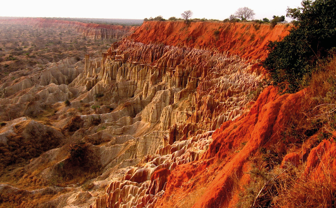
The Miradouro da Lua near Luanda. The geology shows the building and uplift of the Late Neogene Paleo-Cuanza delta. © David Mark/Pixabay.
This quandary is particularly apparent in the coastal basins of West Africa, where the Mesozoic sedimentary successions, including salt, extend into the onshore domain. In this basin, seasoned explorers will be tantalised by the opportunity to drill salt-induced prospects within a proven petroleum system and will be seeking the necessary datasets with which to de-risk them.
There are, however, onshore basins where this quandary is not so apparent; where extensive high quality datasets are available and early exploration has suitably de-risked proven pre- and post-salt petroleum plays. One such example is the Onshore Kwanza Basin of Angola – a Mesozoic salt basin with numerous undeveloped fields, a library rich in accessible yet low-cost exploration datasets and local refineries and markets for hydrocarbons once they are produced.
Furthermore, a licence round that opens towards the end of 2020, supported by new oil and gas laws and fiscal incentives, provides the opportunity for oil companies to secure rights to this acreage, appraise discovered fields and potentially fast-track commercially viable hydrocarbon production.
Underexplored Pre-Salt, Onshore Kwanza Basin
To understand the future potential of the Onshore Kwanza Basin, we must first understand its exploration history. A key milestone occurred in 1955 when the post-salt Benfica oil field was discovered just south of Luanda, after which exploration drilling peaked; by the late 1970s 133 wells had been drilled. This era of activity saw the discovery of 11 oil fields, as well as a few gas fields, with the largest containing more than 200 MMboe, made possible by the availability of 11,500 line-km of dynamite 2D seismic data. The last onshore field discovery was in 1972 and the last well was drilled in 1982, from when on interest in the onshore declined, in part due to socio-political stability risks but more likely due to the early successes of offshore exploration. Only nine oil fields have ever been reported as having been put onto production, which include the Cacuaco and Puaca fields, both with pre-salt reservoirs.
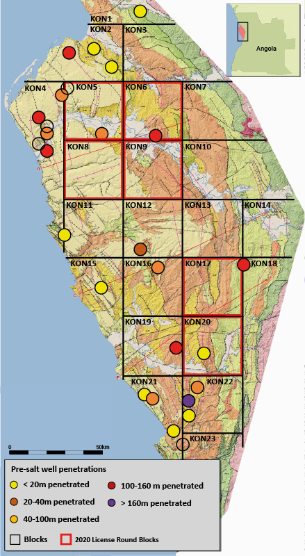
Revised KMAP-2020 geological map derived from recent satellite imagery and fi eld studies. Pre-salt well penetrations and 2020 License Round blocks are shown. © Trois Geoconsulting.
Although at first it appears that the Onshore Kwanza has been considerably drilled, analysis of well penetrations and results tells a story of high success rates in post-salt wildcats contrasted with a prospective yet significantly underexplored pre-salt succession. Of the 237 wells drilled, just 28 penetrated beneath the salt; four pre-salt fields were discovered prior to 1971 (Cacuaco, Uacongo, Puaca and Morro Liso) despite only three wells testing a meaningful section of pre-salt stratigraphy. When our seasoned explorers analyse the results of these pre-salt wells they must be left pondering what might have been found had the operator drilled a little deeper. An initial observation is that the majority of pre-salt penetrations were drilled from wellheads located for post-salt prospects with only a handful of wells spudded with a pre-salt objective. Furthermore, assumptions about 1960s and 1970s technology and know-how suggest that modern field appraisal methodologies could reveal where discovered fields may actually be commercial, whilst advanced well stimulation techniques could lower the commercial threshold.
Updated G&G Datasets Support Oil and Gas Exploration Onshore Angola
In 2010 and 2011, 2,581 line-km of high quality 2D seismic data was acquired followed by the acquisition of high resolution aeromagnetic data. A new GIS GeoDatabase named KMAP-2020, commissioned by Sonangol in 2015, was then completed as part of the reassessment of the remaining oil potential ahead of licence rounds. This product, available for the whole onshore basin or for individual blocks, includes outcrop information, petrographic studies and palaeontological reports from recent field trips together with seismic profiles, well stratigraphy panels and geosections.
The KMAP-2020 database has recently been further refined by the inclusion of modern satellite imagery supplied by specialist, Tectosat Ltd. Using Landsat imagery, SRTM DEM, ASTER and PALSAR Radar data*, the whole basin has been remapped at a much more comprehensive 1:50,000 scale involving interpretation at 1:25,000 scale, with additional integration of lithological detail from some 3,000 field sample points.
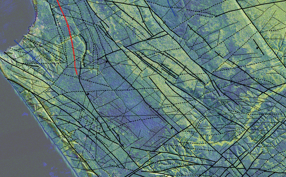
KMAP-2020 PALSAR data with shaded DEM showing the geological structure around the Cabo Ledo fault; note the differentiation between deepseated and shallow faulting. © Tectosat Ltd.
The resulting updates to the surface geology maps within the KMAP-2020 database have positive implications for de-risking the underlying petroleum systems. Halokinetic activity is evinced in anomalous domes and basins showing salt withdrawal and folding adjacent to the main bounding faults of the Tertiary troughs.
Fault expressions mapped at surface have been used to understand structural controls related to various tectonic episodes. Where it is shown that many of the Tertiary-aged faults are soft-linked to deeper syn-rift structures, the charge of post-salt reservoirs with pre-salt oil can be de-risked. Similarly, areas of Tertiary uplift are observed in the vicinity of Blocks 11 and 12 where present-day river systems are seen to have incised; this uplift may have hinged to the north at the Cabo Ledo fault. These details are key in determining long-distance migration paths from known source kitchens, including the offshore, into pre-salt and post-salt structures; indeed, the presence of basin margin oil seeps together with the pre-salt Cacuaco Field north-east of Luanda suggest that the sub-salt section should be suitably charged.
Underexplored Area in New Onshore Angola Licence Round
An integration of past exploration results, available seismic and well datasets with the KMAP-2020 database (which includes the satellite imagery interpretation) demonstrate that the Onshore Kwanza Basin is a world class petroleum basin that in recent decades has been considerably underexplored.
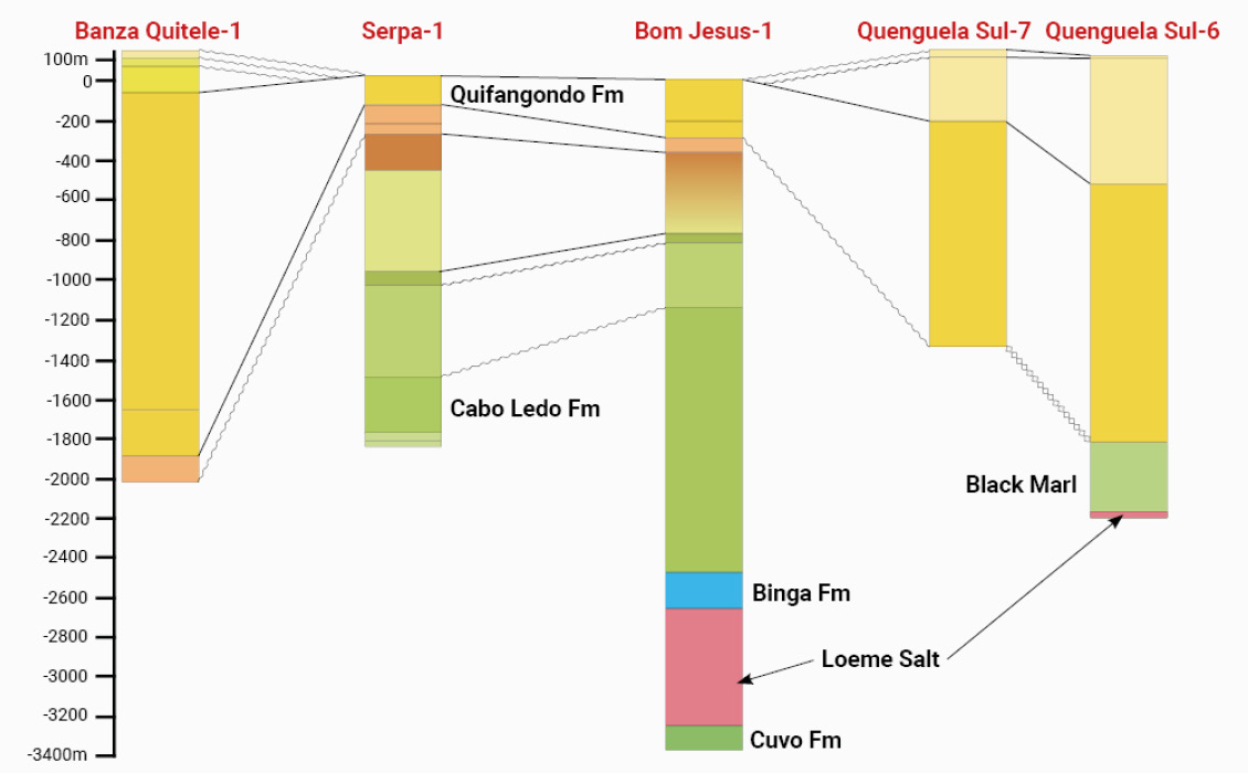
Simplified example well-section from the KMAP-2020 report; note the limited pre-salt penetration in the Bom Jesus well. Source: Sonangol.
The post-salt section has numerous anticlinal closures that are untested; where these have been drilled the structures exhibit good reservoir qualities and host viable oil fields, such as those at Quenguela and Benfica. Where sampled, the pre-salt is shown to exhibit good quality carbonate reservoirs formed by coquina shoals with vuggy porosities as well as fluvial-deltaic sandstones. The hydrocarbons encountered here are light oils with gas and with no known encounters of CO2 or high sulphur content.
When the results of the updated ArcGIS geological study are combined with available seismic and well datasets, conclusions can be drawn that suggest that the upcoming licence round may be the trigger for the first commercial production of oil from onshore Kwanza.
Recent announcements by the newly formed ANPG (National Agency of Petroleum, Gas and Biofuels) have defined a strategy for the allocation of petroleum concessions including open acreage within all of Angola’s basins. Concessions will be awarded through a process of public tender, restricted public tender and direct negotiation over a period of seven years, starting in 2019 and culminating in 2025. The blocks offered by public tender are those that are deemed exploration blocks that have not formerly been abandoned and restored to the state.
The blocks of the Onshore Kwanza Basin have been announced as a part of the 2020 licensing round, which will open in the fourth quarter of 2020. Blocks KON5, KON6, KON8, KON9, KON17 and KON20 are offered by public tender and these blocks all offer excellent potential for exploration as well as opportunities to appraise and develop discovered fields.
In August this year, the ANPG held a Clarification Session as a precursor to the opening of the round; during this session senior members of ANPG gave informative presentations and clarified the timeline for the submissions of bids and signature of the contracts.
Exceptional Hydrocarbon Opportunities in the Onshore Kwanza Basin
The history books of exploration bear witness to a multitude of junior exploration companies that secured onshore acreage, within a known petroleum province, yet were unable to successfully demonstrate to investors and potential farm-in partners that they could cost effectively de-risk a drilling location.
The Onshore Kwanza Basin is different in that it offers the opportunity to secure acreage containing a post-salt field or prospect that can potentially be appraised and brought into production, providing cash-flow to fund further pre-salt exploration where the prize may be bigger. The 2020 Angola Licence Round should therefore be in the plans of all junior and mid-sized oil companies.
* SRTM DEM (Shuttle Radar Topography Mission – Digital Elevation Mapping), ASTER (Advanced Spaceborne Thermal Emission and Reflection Radiometer), PALSAR (Phased Array type L-band Synthetic Aperture Radar).


