
The Gulf of Suez is a prolific rifted hydrocarbon province that has been actively explored and developed since 1922. Oil exploration in this area hit its peak between 1960 and 1980 with the discovery of several billion-barrel oil fields such as Morgan, July, October and Ramadan. Since the 1980s the number of new discoveries has slowly tapered off. Unlike most prolific basins, this region did not undergo a rejuvenation of new discoveries through the application of 3D seismic technology employed from the 1980s to present. One explanation for this may be attributed to the complex seismic imaging problem posed by the presence of thick irregular geometries of interbedded salts and anhydrites in the overburden.
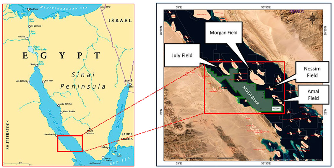
Figure 1: Maps showing location of North West El Amal concession along with surrounding major oil fields. Left map: Shutterstock.
It has been extremely challenging to image through this overburden section using the narrow azimuth and short offset 3D towed streamer configurations deployed in the past. We highlight in this article how Neptune Energy and Schlumberger Multiclient, working in collaboration, have used modern 3D ocean bottom node (OBN) seismic technology to image beneath the salt and unlock further exploration potential within the North West El Amal (NWEA) Block of the Gulf of Suez.
In February 2020, Neptune Energy signed an operated exploration licence with the Egyptian General Petroleum Corporation for Egypt’s NWEA Offshore Concession located in the southern part of the Gulf of Suez (Figure 1).
The work programme for this concession included a commitment to acquire new seismic over the block. A model-driven approach was used to understand the impact of different acquisition geometries and help select an optimal survey design that would meet the demanding pre-salt imaging objectives (Gruffeille et al., 2020). The final acquisition design employed a high density, wide azimuth multiclient OBN seismic survey operated by Schlumberger Multiclient in 2020 (Byerley et al., 2021). A portfolio of new prospects has since been worked up using this new dataset and Neptune Energy is now preparing to drill the first exploration well into the Yakoot prospect later this year where the primary target is the pre-Miocene Nubia Sandstone.
Geologic Setting
The Gulf of Suez is a Late Oligocene – Early Miocene age failed continental rift basin, located between the Sinai Peninsula and the Eastern Desert of Egypt. The basin lies at the northern end of the Red Sea – Gulf of Aden rift system, formed through the divergence of the Arabian and the African plates (Coleman, 1993: Hempton, 1987).
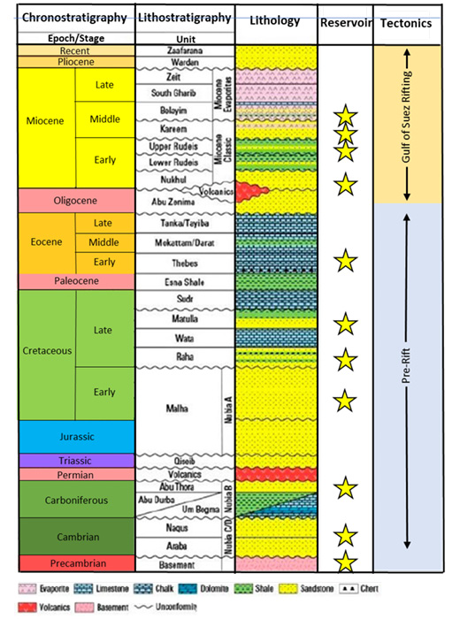
Figure 2: Gulf of Suez stratigraphic section. Neptune Energy (after Moustafa, A.R. and Khalil, S.M. 2016)
The pre-rift sedimentary section unconformably overlies Precambrian crystalline basement and ranges in age from Palaeozoic to Eocene (Moustafa, 1976; Bosworth, 1995; Patton et al., 1994; Moustafa et al., 2016). The oldest pre-rift sedimentary unit is the Palaeozoic – Lower Cretaceous Nubia Sandstone which is one of the main producing reservoirs in the basin, along with secondary reservoirs in the Matulla, Waha and Raha Formations. World class source rocks in the Thebes and Brown Limestone Formations overlie these reservoirs.
The syn-rift section is sedimentary and includes a clastic section of sandstones, including reservoir targets in the Kareem and Lower Rudeis sand, interbedded with shales and anhydrites transitioning to a section of thick evaporites at the top. The evaporites section consists of the Belayim, South Gharib, and Zeit Formations. The post-rift, post-Miocene section of the overburden is characterised by poorly consolidated dominantly clastic rocks.
The NWEA Block lies in the southern part of the Gulf of Suez within the proven Nubia Sandstone petroleum system. Neptune has estimated that, within NWEA, more than 3.5 to 5 billion barrels of oil have been generated. The block is surrounded by major oil fields including Morgan, July, Ramadan, Amal, Gamma, Shukheir and GS345 fields, all of which produce oil and gas from Miocene and pre-Miocene reservoirs.
The most prospective intervals of the NWEA Block are the pre-Miocene reservoir sands with the primary target being the Nubia Sandstone. The Nubia Sandstone is at approximately 3 km depth within the rotated fault blocks set up by the sequence of rifting mentioned above.
Seismic Processing
Full-waveform inversion (FWI) started as soon as the field data had been received and geometry corrections were applied. Minimal data pre-conditioning was applied for FWI; this included data deblending, anomalous amplitudes removal and some signal enhancement. All offsets were kept for FWI reaching up to 25 km in the middle of the NWEA area.
The processing flow started with node positioning, rotation and timing QC, then progressed to tackle the noise. The main noise attenuation steps took place in the receiver domain to make use of the fine sampling of the shots. For wavefield separation and surface multiples removal, up-down deconvolution (UDD) was used (Brunellière et al., 2004).
Interbed multiple prediction was a significant challenge as almost all the layers from the water bottom up to the salt body are considered as strong multiple generators. Both streamer and OBN data were used to predict the interbed multiples through the extended interbed multiple prediction technique which is an extension of general surface multiple prediction (GSMP) (Jackubowics, 1998). Streamer data were used as a source and interbed term while the OBN data were used as the receiver term. All multiple generators were included in the prediction process.
The velocity model building was done using a cascaded top-down approach; the initial model contained a representation of the four main layers of Gulf of Suez: shallow sediments, evaporites, salt and pre-salt sediments. FWI used early arrivals, and guided waves to update the shallow sediment velocities, then mid-offset refractions to update evaporites and mid-to-far offset refractions were used to update the salt velocities. Short streamer data were used to update the shallow sediments before the evaporite updates. Reflection data were used after that to fine-tune the thin evaporite intercalations.
Results and Interpretation
The first results from the reverse time migration (RTM) images of the new OBN dataset showed credible images of the pre-Miocene rotated fault blocks which became the focus of further improvements during processing. Further seismic calibration to well data confirmed that the dips observed along the main seismic horizons beneath the salt agreed much better with the interpreted dip-meter data acquired in the existing wells. Figure 3 shows an inline and crossline comparison between the legacy towed streamer seismic (top) and the new OBN seismic (bottom) across Neptune’s Yakoot prospect, which quickly matured from a lead to a drill-ready prospect once it was mapped.
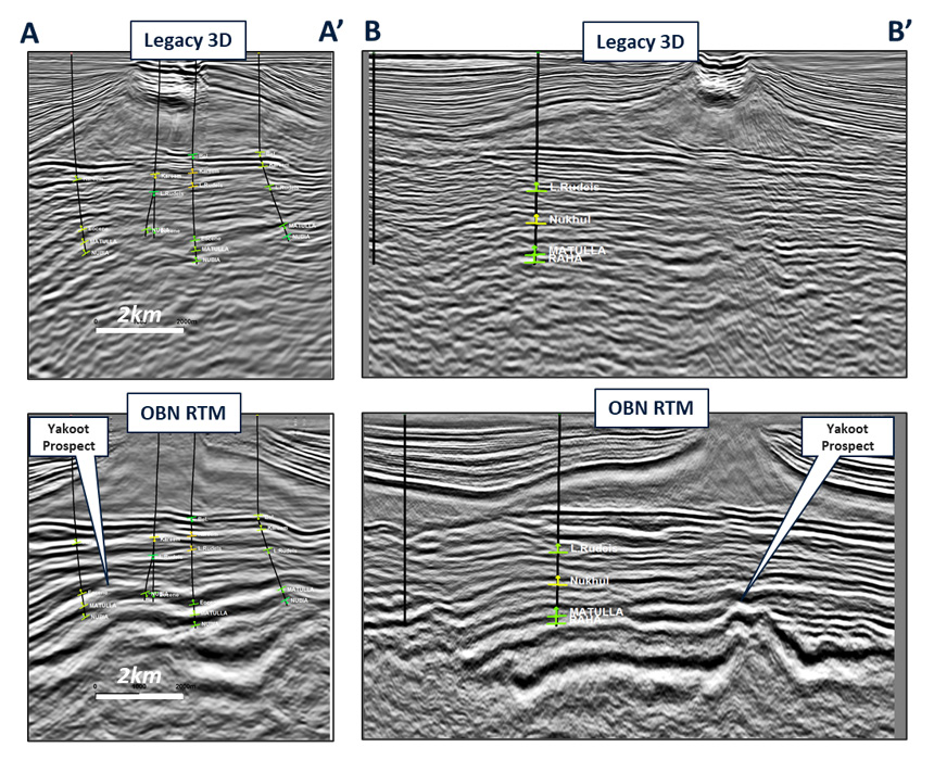
Figure 3: Comparison of crossline (left) and inline (right) seismic cross-sections between the legacy PSDM (top) and the new OBN RTM (bottom). OBN seismic courtesy of Schlumberger Multiclient.
Pre-Miocene Play
One can argue this is the first time these pre-Miocene structures have been imaged and mapped in this area with any confidence. The ability to do this has also improved Neptune Energy’s capacity to de-risk the structural trap, which is a critical risk that underpins the probability of geologic success of prospects across the whole area. It is important to note that even the best seismic data comprises imperfect information with irreducible uncertainties. The value gained from the OBN data will ultimately come down to demonstrating an improved chance of success over several prospects within the survey area.
One example of this is the Yakoot prospect (Figure 4), located in the south-eastern part of the block approximately 10 km south-west of the Morgan field and 8 km west of the El Amal field. The prospect is structurally controlled by a pre-Miocene Nubia and Nezzazat horst block situated up-dip of logged reservoir pay identified in adjacent wells GS 344-1 and GS 344-1A. The improved imaging of the pre-salt section delivered better confidence in the fault interpretation over the prospect. The assessed probability of success on the Yakoot prospect improved significantly from 33% to 66% following the interpretation of the new OBN seismic.
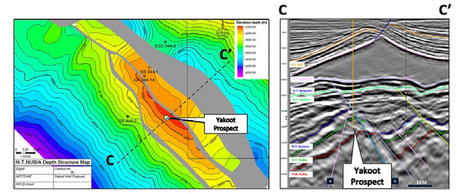
Figure 4: Top Nubia structure map (left) and OBN seismic cross-section through the pre-Miocene Yakoot prospect (right). OBN seismic courtesy of Schlumberger Multiclient.
Unlocking Miocene Play Potential
The Miocene clastic section within the North West El Amal Block consists of interbedded sandstones, with reservoir targets in the Kareem, Rudeis and Lower Rudeis Formations, with the nearby Morgan field producing from Kareem Formation fan/lobe sandstones. The latest OBN seismic has improved the image below the salt and therefore the ability to map these key horizons.
It has also helped to visualise sand geometries and pinch-outs and the identification of more complex stratigraphic and combination traps within the Miocene section, rather than simply relying on structural trapping geometries.
One example is shown in Figure 5 where Kareem and Rudeis sands were mapped to define the Coral prospect. Extracted amplitudes from some of these Miocene horizons appear to show channel and fan morphologies which have become the focus of ongoing reservoir characterisation studies aimed at predicting sand presence directly from the seismic. This work will play a critical role in further de-risking the presence of reservoir and stratigraphic traps within the Miocene play.
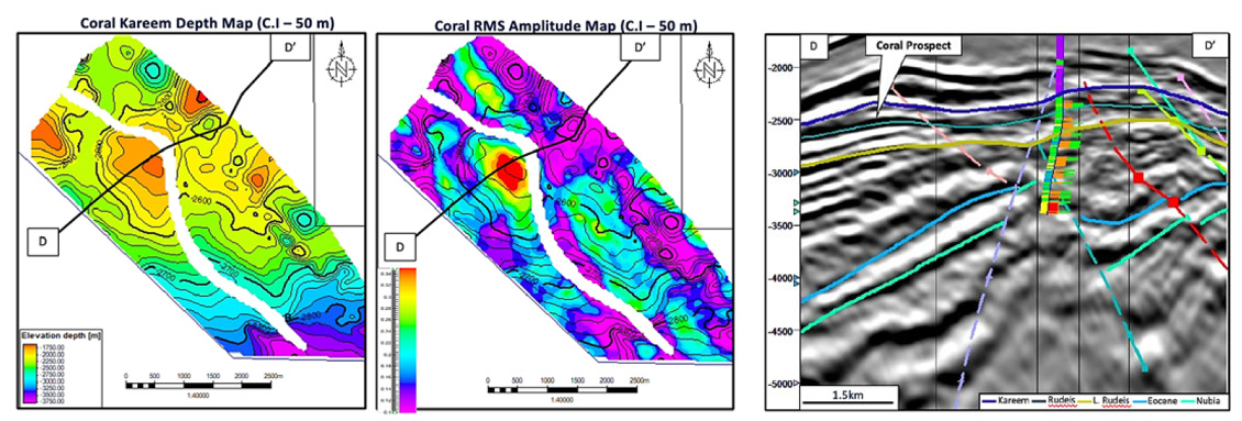
Figure 5: Kareem structure map (left) with extracted RMS amplitudes from the seismic (middle) and seismic cross-section across the Miocene Coral prospect (right). OBN seismic courtesy of Schlumberger Multiclient.
Rejuvenating Exploration in a Very Mature Basin
A thorough evaluation of the new OBN seismic data has focused on the interpretation of multiple play types through the Miocene and pre-Miocene sections. This effort has helped replenish a portfolio of new exploration opportunities in very a mature basin. The evaluation has added new prospects with resource potential of approximately 200 million barrels of oil (unrisked) within the NWEA Block of the Gulf of Suez.
Improved imaging of both structural and stratigraphic traps on the new OBN data has helped de-risk several of these opportunities into low-risk exploration opportunities. The first exploration well impacted by the new OBN seismic data is to be drilled later this year, while several other prospects are being high-graded into drill-ready prospects to provide additional running room on the back of a successful outcome.
Acknowledgements
The authors would like to thank Neptune Energy Group, Schlumberger Multiclient and Egypt General Petroleum Corporation for permission to publish this work. The authors also acknowledge Axxis Geo Solutions for their seismic acquisition services and ACTeQ for support on the initial survey design on this project. Special thanks to Dave Monk for his contributions to the survey design used for this project.


