The global energy sector from a subsurface perspective
The lighthouse in Alexandria looks out over the waters west of the Nile Delta, an area as yet poorly explored for hydrocarbons. Source: marinadatsenko via Adobe Stock.
Hydrocarbon exploration success offshore Egypt to date is mainly associated with the prolific Pliocene sequence in the Nile Delta Basin, but as the recent Zohr discovery shows, there are other potential plays to follow. Here, we look at the relatively unexplored area of offshore West Egypt
Simon Baer, Øystein Lie (PGS) and Ayman Almorshedy (EGAS)
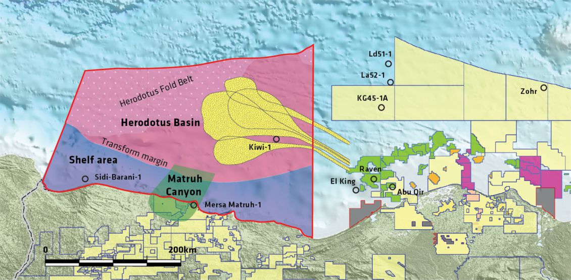
The frontier exploration area offshore West Egypt (Figure 1) consists of several structural domains (Figure 2) including, from south to north, a comparatively narrow shelf zone; a west-south-west to east-north-east trending transform margin; parts of the Herodotus Basin; and the Herodotus Fold Belt to the north-west. The onshore extension of this area contains a proven petroleum system for both oil and gas, as evidenced by the Matruh and Emerald fields.
To date, exploration in this large area has been limited, and consequently the petroleum systems are currently not well understood. Only two exploration wells, Kiwi-1 (2010) and Sidi Barani-1, (1976) have been drilled, and both were dry, although Kiwi-1 did prove very good sandstone reservoir properties of Rupelian age (Figure 5). New seismic 2D data acquisition is currently being planned to enable a full assessment of the petroleum system in this area. These data will form the basis for a future licensing round tentatively planned for 2017.
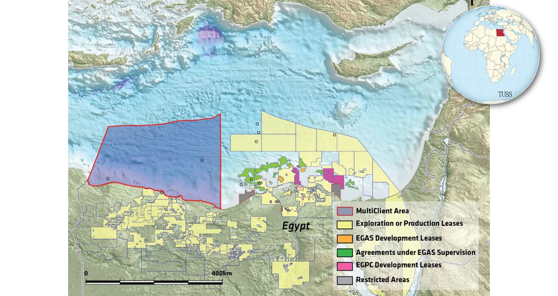
Figure 1: Location map of Egypt’s Mediterranean Sea area showing licensed acreage together with the 80,000 km2 frontier area west of the Nile Delta.
Petroleum Systems
Different potential play types have been identified utilising seismic data, well information and existing discoveries from analogous geological settings such as onshore discoveries in Western Egypt, the recent Zohr gas discovery (Figure 2) or other giant discoveries in the Levant Basin. Play types can be identified in four different geological domains, which are described below and illustrated on legacy lines in time.
Figure 2: The study area, outlined in red, includes several different geological domains based on interpretation of existing data: the Shelf area, the Matruh Canyon, the Herodotus Basin and the Herodotus Fold Belt. The relevant exploration wells within the survey area and in the vicinity are marked on the map. The yellow stippled areas are potential basin floor fans from the Nile Delta.
New Geophysical Data Needed
The existing geophysical 2D and 3D data coverage is limited, and the 2D generally poorly images the subsurface in many areas where it has been acquired. Reprocessing of this legacy 2D data, which consists of three surveys from 1999, 2005 and 2007, is currently being undertaken using up-to-date broadband processing sequences, in which both receiver- and source-side deghosting will be applied. De-noise techniques including demultiple will be very important in addition to pre-stack depth migration to optimise the use of this vintage data.
A new 2D GeoStreamer® broadband data acquisition programme of approximately 5,000 line km has been planned. Combined with the reprocessed legacy data, it is hoped that this will improve the definition and understanding of the structural and lithological trends that have been interpreted using the old existing data. The new data will be positioned in areas where the legacy coverage is poor, such as the south-eastern part of the Shelf area and within the Herodotus Basin (Figure 2). Infill to the existing 2D coverage will also provide better control when identifying and quantifying potential leads. In this frontier area, tie lines to exploration wells outside the survey area will be highly important. Ties from the two exploration wells within the survey area to pre-salt gas discoveries (exploration wells Ld51-1, La52-1, KG45-1A) and an Upper Miocene – Lower Pliocene oil, gas and condensate discovery (exploration well El King) would be valuable (Figure 2). 2D gravity and magnetic data is included in the new acquisition programme planning to further enhance the geological understanding of the area.
Stimulating Further Exploration
The reprocessed upgrade of the legacy data, combined with the new broadband data coverage, are essential for defining new play types and are expected to reveal similar potential to that seen in analogous geological settings like the deep Nile Delta and west Cyprus. The seismic data will be the basis for defining new exploration blocks and for future licensing rounds. The objective is to provide both EGAS (Egyptian Natural Gas Holding Company) and the industry with optimum geophysical data, allowing a better understanding of the complex geology and helping stimulating further exploration in the area.