
The Gulf of Mexico (GOM) petroleum system is one of the most productive and studied ‘super basins’ in the world, yet uncertainties remained with regard to its fundamental crustal structure. For decades, the 15 km-thick sedimentary and evaporitic infill had obscured the accurate observation of the deeper continental and oceanic basinal structure, making it difficult to unravel the Triassic to Jurassic opening phases and their precise directions of opening. Observations that long puzzled geoscientists studying the area included a wider zone of thinned continental crust in the northern GOM and a corresponding narrow zone along the Yucatan margin; a deep central GOM underlain by oceanic crust; and a salt province separated into two unequal parts. (The larger Louann salt province covers most of the US continental margin while Campeche salt covers a smaller area of the Mexican margin.)
The 2014 publication of high-resolution satellite images of marine gravity data by Dr. David Sandwell of Scripps Institute of Oceanography and colleagues has led to greatly improved mapping, including the locations of fracture zones and spreading ridges. Previous plate models by Dr. James Pindell and colleagues provided the overall plate framework for the crescent-shaped oceanic crust that resulted from the late Jurassic, counterclockwise rotation of the Yucatan Peninsula. The new gravity data provides the precise location of fracture zones, allowing researchers to match the well-known and highly productive northern margin to its underexplored southern conjugate. This concept has helped geoscientists discover productive new petroleum basins across other conjugate margins such as those on either side of the South Atlantic Ocean (see: Is a Conjugate an Analog? GEO ExPro, Vol. 15, No. 4).
“With the new images, the long puzzling GOM observations suddenly made more sense,” says Dr. Paul Mann, director of the Conjugate Basins, Tectonics and Hydrocarbons Consortium (H) at the University of Houston. “A ‘two phase opening model’ was presented in a series of papers by Drs. Gail Christeson, Ian Norton and colleagues at the University of Texas. The first phase separated North America from the Yucatan-South American Plate in a north-west to south-east direction (diagrams a-c) in the late Triassic to early Jurassic (190–170 Ma). Near the end of rifting in the Middle Jurassic, salt was deposited in a large sag basin overlying rifted continental crust (diagram d). In the late Jurassic (second phase of rifting) the motion changed from north-west to south-east to north–south along the Mexican margin as the Yucatan Block began to rotate in a counterclockwise direction. That motion can now be accurately traced along mapped fracture zones (diagrams e and f). The two-phase model helped explain the much wider area of continental extension in the US GOM and the deposition of salt into a sag basin overlying that area of extension. The second phase of rifting was more confined to the edges of the oceanic crust in the central GOM. By earliest Cretaceous, strike-slip motion along the Western Main Transform (WMT) and seafloor spreading ceased.”
Eastern Gulf
The central and eastern GOM contains a whole host of plays and this offshore region produces about 17% of US oil. The Norphlet and overlying Sackover formations in the eastern portion of the petroleum province west of the Florida margin have been relatively recent additions to the GOM’s growing list of successful plays. The Upper Jurassic aeolian sandstones of the Norphlet Formation have been a prolific onshore play and geoscientists postulated that it could extend into the deep waters of the eastern GOM. The Smackover Formation is the primary source for Norphlet oil and also acts as an effective reservoir seal. Drilling has proved the geoscientists correct, with Shell making a series of discoveries starting in 2003 (see: Puzzling Salt Structures; GEO ExPro Vol. 12, No. 2). The 2017 Chevron and Total Norphlet discovery at Ballymore is the most recent find in this impressive play. Leasing further offshore is scheduled and could extend the Norphlet fairway.
Available data for southern Gulf
Much explored, the central and eastern GOM has impressive grids of seismic data that has been tied to an equally impressive number of wells. The Florida margin is currently off limits to exploration, but still has abundant seismic data tied to wells. The Yucatan conjugate remains largely underexplored, with Spectrum Geo’s 2016 seismic data being the only regional grid available in the area. None of this deepwater acreage in the Mexico GOM has yet to be offered for lease.
“Spectrum Geo supplied 24,500 line-km of 2D seismic reflection data for my study of the Yucatan margin,” says Andrew Steier, who was supported at the time as a CBTH research assistant and a masters student at the University of Houston and is now with the GOM exploration team at Total in Houston.
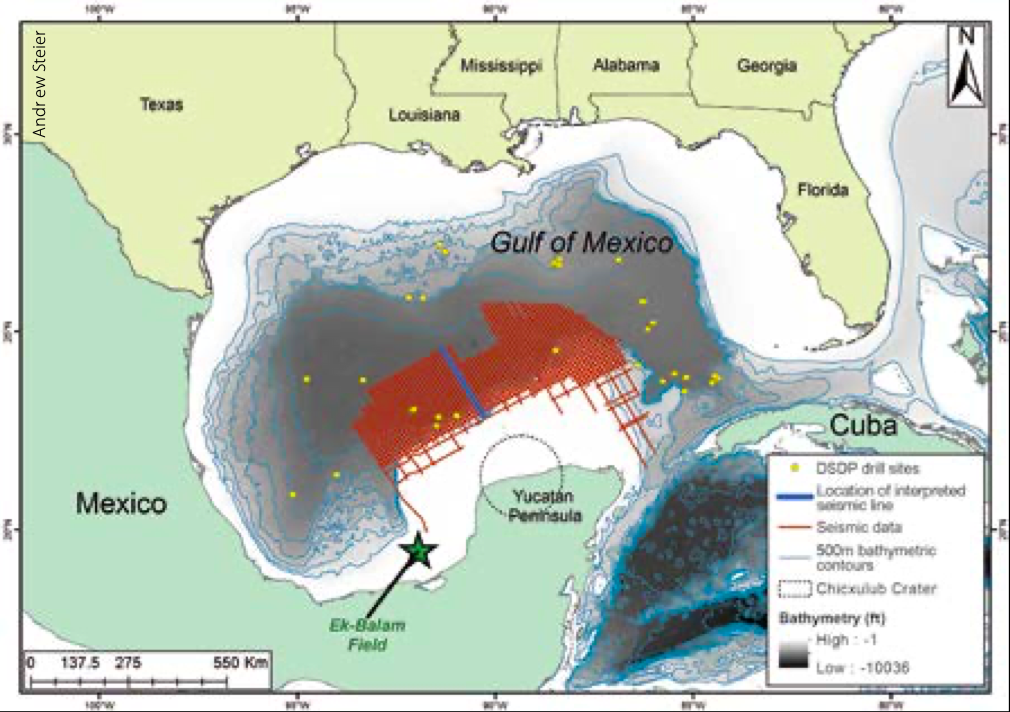
“The seismic grid covers approximately 117,000 km² along the northern Yucatan margin with 10 km spacing. The dataset spans the shelf, slope, and basinal areas in water depths from 50m to 3,800m. There are no published industry wells and just seven Deep Sea Drilling Project (DSDP) wells. Four were drilled in deep water, but none penetrated the Mesozoic section. I relied upon published regional seismic lines that have been tied to wells penetrating the Mesozoic to tie into this study’s data set. The top Jurassic pick is speculative being approximated from the thickness of post-salt Jurassic and Cretaceous sections observed in the deepwater US GOM.”
Structural Evolution
“The structural evolution of the northern Yucatan margin varies with the relative thicknesses of salt,” says Andrew. “The north-eastern margin exhibits minimal salt and the late Mesozoic section is relatively undeformed. The central area is notable for the development of salt rollers and associated sedimentary growth wedges. Finally, the south-western area features few salt rollers but numerous diapirs large enough to deform Holocene strata. This area exhibits the most complex salt deformation in the region.”
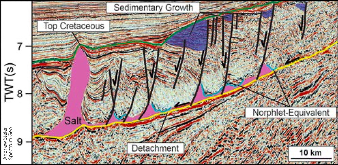
Salt deposited in the GOM sag basin has been assumed to have been deposited with little topographic relief at its top. Norphlet and Smackover formations and equivalents that were deposited above the salt exhibit only a slight wedge geometry. The early and late Cretaceous strata exhibit substantial thickening toward updip, normal faults and Cenozoic strata are largely undeformed. “These thickness changes and deformation indicate the majority of downslope movement on the salt detachment occurred during the Cretaceous,” says Andrew, “and was likely accompanied by progressive subsidence and deepening of the late Jurassic oceanic crust underlying the central GOM. The deep GOM formed by slow and steady subsidence over the past 140 Ma with the dense oceanic crust acting as an anchor pulling down the adjacent areas of thinned continental crust.”
Conjugate Basins, Tectonics, and Hydrocarbons Consortium
After working on other tectonic settings of the Caribbean and the northern South American region since 2005, Paul Mann, director of the industry Conjugate Basins, Tectonics, and Hydrocarbons Consortium (cbth.uh.edu) and his group began working the GOM in 2012. They started studying the eastern GOM because the thinner salt and sediment thickness produced better seismic imaging and the availability of extensive grids of industry seismic data. Seismic data from Spectrum and Dynamic Data Systems allowed geoscientists supported by the consortium to map the Florida margin from the north-eastern Gulf to the area north of Cuba. In one study, Pin Lin (PhD, 2018) used Spectrum seismic and released well data to map fracture zones and spreading centre locations in the eastern GOM, along with the crustal structure of the oceanic crust to Moho depths.
With the publication of the Sandwell gravity data, the CBTH team was able to focus on mapping and modelling of the continent-ocean boundaries including the WMT along the margin of eastern Mexico. In 2016, new Spectrum seismic data along the Yucatan margin allowed them to set up their first southern conjugate margin study, presented in this article. Future CBTH supported work includes students working on the Florida-Yucatan margin north of Cuba and continuing gravity-magnetic work on refining the extent of oceanic crust in the eastern GOM and restoring the two margins to the pre-rift locations.
Norphlet Reservoir Fairway
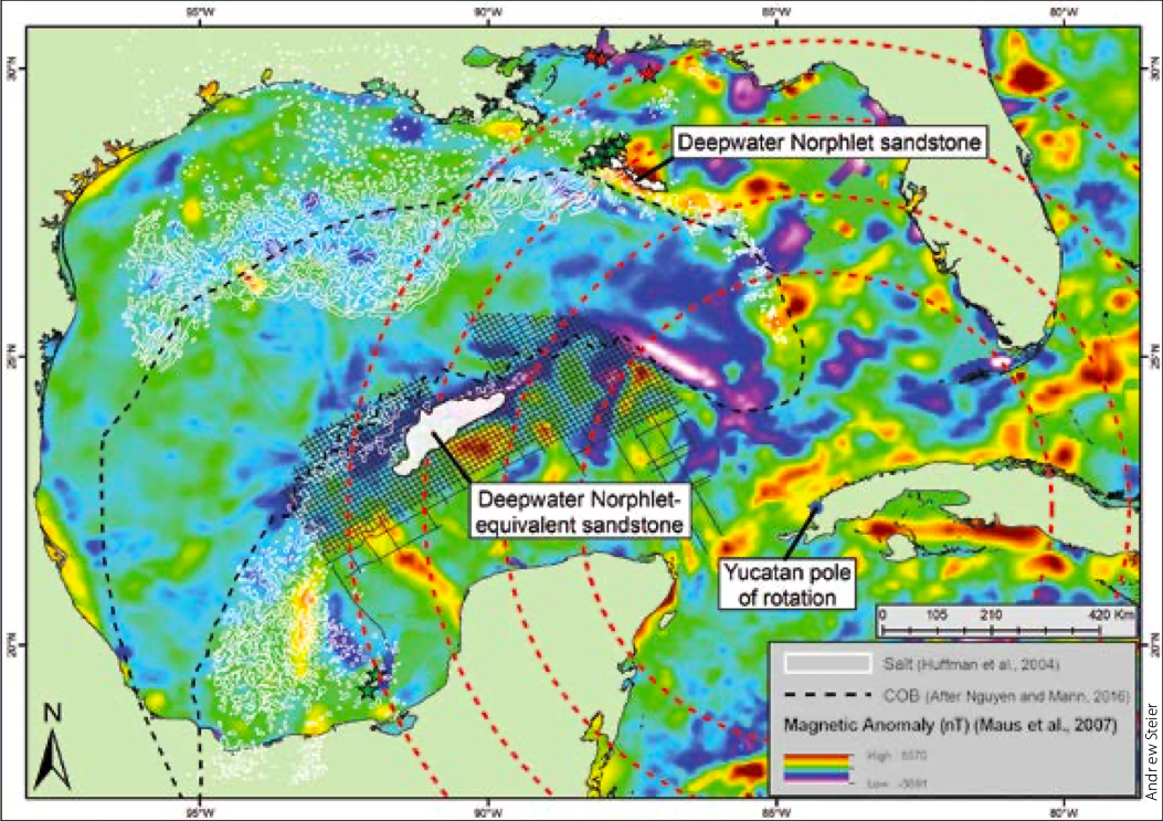
“Potential hydrocarbon trap and seal combinations abound in the salt-deformed late Jurassic to Cretaceous section on the northern Yucatan margin,” says Andrew Steier. “The trapping styles are similar to those utilised at the deepwater Norphlet sandstone discoveries of the north-eastern GOM. For these reasons, my study focuses on the palaeogeography (the location of a potential Norphlet equivalent fairway) and structural evolution of the Mesozoic section rather than the subhorizontal, gradually onlapping Cenozoic section.” This is not to say the Cenozoic section is not prospective. In a 2017 article (see: Regional Play Types in the Mexican Offshore; GEO ExPro Vol. 14, No. 4), TGS geoscientists identified numerous play types in the Mexican offshore, including the Mesozoic section covered in detail in this article. They also identified undrilled prospects in the Paleocene to Eocene Wilcox sands as well as younger prospects in Miocene to Pliocene sands, all of which are major players in the US sector of the GOM.
“By using fracture zones, we have been able to rotate the Yucatan continental block back to its pre-rotational location,” says Andrew. “These linear fracture zones equate to small circles around the late Jurassic to earliest Cretaceous pole of rotation and trace the path of the Yucatan block during seafloor spreading. Basically, these small circles connect the two conjugate margins of Yucatan and Florida and reunite the Norphlet equivalent mapped north of the Yucatan margin with the deepwater Norphlet discoveries along the northern GOM conjugate margin.
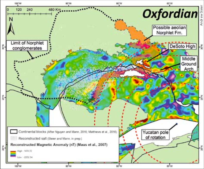
“Using the Oxfordian reconstruction, the known production from aeolian sandstones equivalent to the Norphlet in the Bay of Campeche at the Ek-Balam and Caan fields, along with the current known extent of the Norphlet sandstone and production in the north-eastern GOM, suggests a continuous fairway of late Jurassic, aeolian sandstone deposition in the GOM basin,” says Andrew. “This would increase the known southern GOM reservoir fairway by 48,000 km² in this underexplored region lying off the Yucatan margin of Mexico, greatly improving the area’s hydrocarbon prospectivity.”
About The Author
Thomas Smith
Contributing Editor, The Americas
Thomas smithTom grew up in a small, eastern Oregon town learning about rocks and nature, before graduating from Oregon State University with a M.S. degree in geology. He took a job with Union Oil Company in Alaska, and spent the next 24 years in the State. He now lives in the mountains of Idaho and enjoys skiing, hiking, fishing, travelling and writing.
Further Reading on Oil & Gas Exploration Along Conjugate Margins
Some recommended GEO ExPro articles relating to, or similar in content to, the exploration and production of hydrocarbons along along conjugate margins.
Is a Conjugate Margin an Analog?
Edwige Zanella, Helen Doran and Jamie Collard; Westwood Global Energy Group
Since the discovery of Tupi in Brazil and Jubilee in Ghana, the search has been on to prove that discoveries on one side of the Atlantic can be mirrored across the ocean. But is a conjugate margin an analog?
This article appeared in Vol. 15, No. 4 – 2018
The Geochemist’s Tool Box
Patrick Barnard, Ian Cutler and Helen Kerr, APT
The conjugate petroleum systems of the North Atlantic, finding hydrocarbons and developing the assets – all viewed through the oil-stained spectacles of geochemistry.
This article appeared in Vol. 13, No. 6 – 2016
Mr. Conjugate Margin
Thomas Smith
Early in his career, geologist Dr. Webster Ueipass Mohriak analysed ‘the whole crust’ along Brazil’s continental margin to become one of the world’s leading experts on conjugate margins.
This article appeared in Vol. 10, No. 2 – 2013


