
 Location map of study area. Blue boxes correspond to extents of palaeogeographic maps in Figure 3 & 4.The Caspian Sea accommodates three major petroleum systems. The North Caspian Basin lies on the southern flank of the Precaspian Basin, where giant oil and gas fields such as Kashagan (up to 13 Bbo recoverable) and Astrakhan (<100 Tcfg) occur within Devonian and Carboniferous carbonate build-ups overlain by Lower Permian salts. The main source rocks here are Late Devonian ‘Domanik’ shales. In the South Caspian, Lower Pliocene clastic reservoirs sealed by intraformational and Late Pliocene mudrocks host numerous large fields such as ACG (the Azeri-Chyrag-Guneshli group; 5-6 Bbo) and Shah Deniz (40 Tcfg).
Between these two hydrocarbon provinces, both in terms of geography and the age of the petroleum systems, lies the Central Caspian province. Blackbourn Geoconsulting has worked on the petroleum systems of the Greater Caspian region for over 20 years.
Here, we outline the large-scale depositional systems responsible for the Mesozoic Central Caspian hydrocarbon province, from the Caucasus and Precaucasus in the west to western Kazakhstan and Turkmenistan in the east, concentrating on the Jurassic.
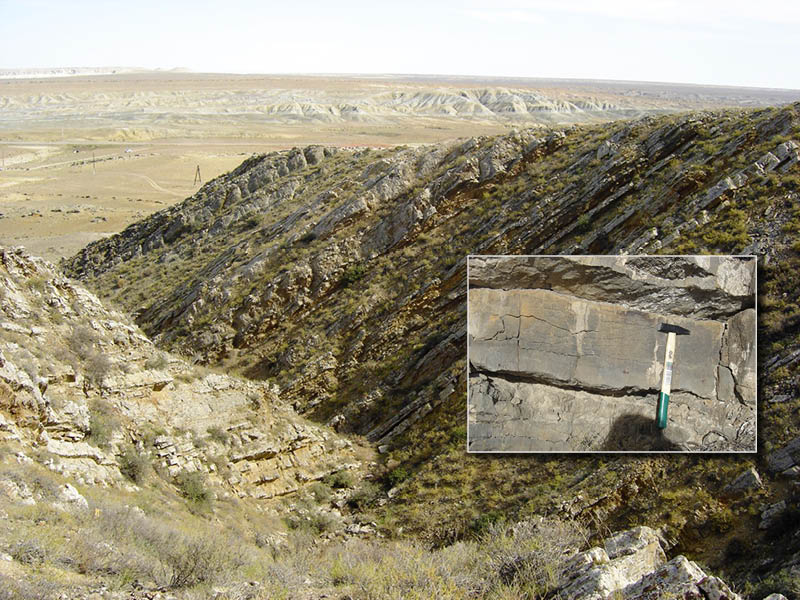 Figure 1: Limestones of the Middle Triassic Khozbulak Suite near Doshan, outcropping on the north side of the East Karatau ridge, western Kazakhstan. © Graham Blackbourn.Our work in the Central Caspian province has been greatly enhanced by numerous field studies undertaken in the Karatau hills of western Kazakhstan, and in Mesozoic (and other) outcrops of the Caucasus in Russia, Azerbaijan and Georgia and the Kopetdag Basin of western Turkmenistan. Examples are provided of how fieldwork, combined with information from the extensive, but often hard-to-obtain, Russian-language geoscience literature, has assisted in developing these models.
Figure 1, full caption: Limestones of the Middle Triassic Khozbulak Suite near Doshan, outcropping on the north side of the East Karatau ridge, western Kazakhstan. These limestones, deposited on a restricted marine shelf, comprise the main oil source rock across a wide area of the Central Caspian province. The inset is a close-up view of one of the individual limestone beds. Where fractured or dolomitised, these limestones (together with Triassic sandstones) also form reservoirs, although the Triassic reservoirs tend to be compartmentalised, and the most productive fields occur where hydrocarbons have migrated into the overlying Jurassic and Cretaceous. © Graham Blackbourn.
Sub-Mesozoic Basement
The basement comprises a mosaic of microcontinental blocks which consolidated during the late Palaeozoic and now extends westwards as the Scythian Platform, and eastwards as the Turan Platform. This Palaeozoic basement is blanketed by younger sediments, and its formation, including successive periods of accretion, rifting and strike-slip tectonism, is poorly understood. Figure 2 presents a conceptual model for the development of the Scythian and Turan platforms (and the Precaspian Basin) during the late Palaeozoic which is broadly consistent with most of the available evidence, although considerable uncertainty remains.
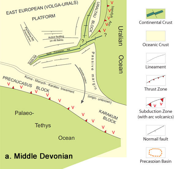
Figure 2: Simplified model for the development of the basement to the Central and North Caspian area during the late Palaeozoic. Owing to an almost complete absence of Palaeozoic outcrop in the area illustrated, except within the Uralian orogen, direct evidence for its tectonic development is sparse and competing models abound. The model illustrated here, according to the principle of ‘Occam’s razor’, is the simplest, which accounts for the great majority of the available data.
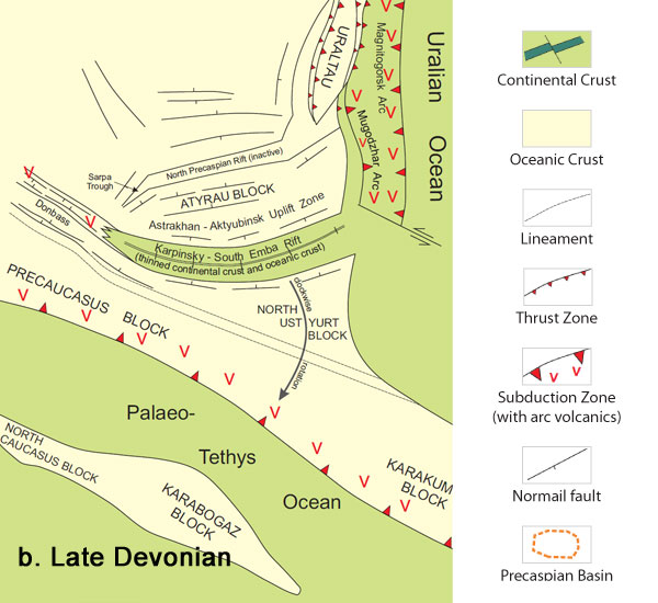
Figure 2: Simplified model for the development of the basement to the Central and North Caspian area during the late Palaeozoic. Owing to an almost complete absence of Palaeozoic outcrop in the area illustrated, except within the Uralian orogen, direct evidence for its tectonic development is sparse and competing models abound. The model illustrated here, according to the principle of ‘Occam’s razor’, is the simplest, which accounts for the great majority of the available data.
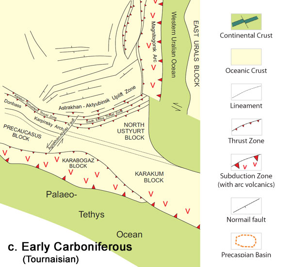
Figure 2: Simplified model for the development of the basement to the Central and North Caspian area during the late Palaeozoic. Owing to an almost complete absence of Palaeozoic outcrop in the area illustrated, except within the Uralian orogen, direct evidence for its tectonic development is sparse and competing models abound. The model illustrated here, according to the principle of ‘Occam’s razor’, is the simplest, which accounts for the great majority of the available data.
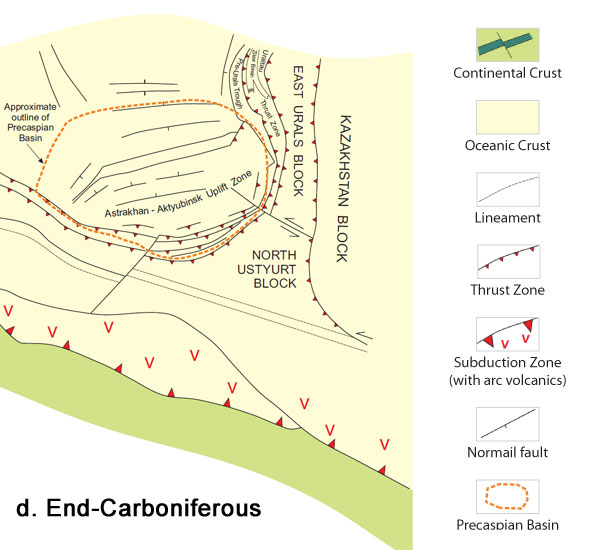
Figure 2: Simplified model for the development of the basement to the Central and North Caspian area during the late Palaeozoic. Owing to an almost complete absence of Palaeozoic outcrop in the area illustrated, except within the Uralian orogen, direct evidence for its tectonic development is sparse and competing models abound. The model illustrated here, according to the principle of ‘Occam’s razor’, is the simplest, which accounts for the great majority of the available data.
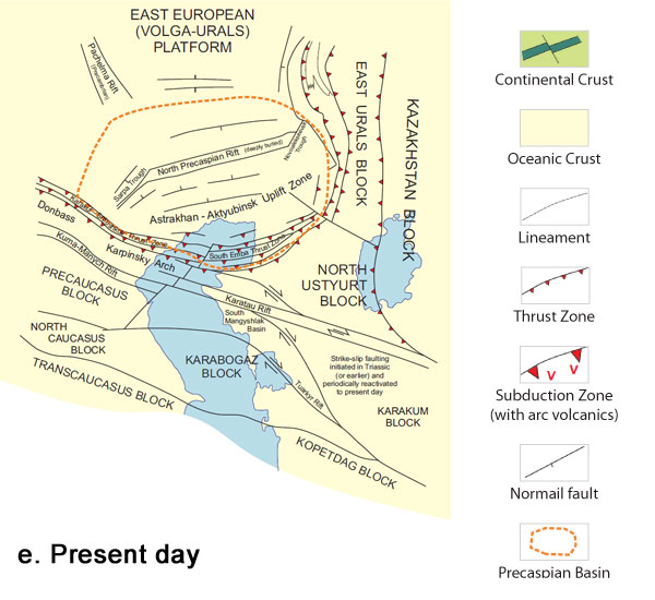
Figure 2: Simplified model for the development of the basement to the Central and North Caspian area during the late Palaeozoic. Owing to an almost complete absence of Palaeozoic outcrop in the area illustrated, except within the Uralian orogen, direct evidence for its tectonic development is sparse and competing models abound. The model illustrated here, according to the principle of ‘Occam’s razor’, is the simplest, which accounts for the great majority of the available data.
The Caspian Sea itself is a relatively recent accident of geomorphology which has little geological significance, apart from in the south. In referring here to the Central Caspian region, we mean those parts of the Scythian and Turan platforms beneath, and to either side of, the present Caspian Sea.
Permo-Triassic Rifting
Northward subduction of Palaeo-Tethys beneath the Central Caspian region during the Permo-Triassic (Figure 2d) created crustal tension, with the formation of linear rifts such as the Manych Trough in the Precaucasus and the Karatau rift in western Kazakhstan. Throughout the Triassic these rifts lay within a wider area of gradual subsidence centred on the present Northern and Central Caspian, and this sedimentary basin was at times isolated from Tethys by the volcanic arc which separated them. Mid-Triassic organic-rich limestones which accumulated within this basin comprise the most important oil source within the Central Caspian region (Figure 1).
Palaeo-Tethys closed at the end of the Triassic when the Cimmerian continent (actually a collage of separate terranes) collided with the south Eurasian margin. The resulting Early Cimmerian orogen was shortlived but intense in the Caspian region. Uplift was particularly marked within the Karatau rift, where sinistral transpression resulted in inversion and intense deformation of the rift fill. A near-complete succession of Late Permian to Late Triassic sediments is now exposed within the former rift zone, unconformably onlapped by a similarly complete and beautifully exposed Early Jurassic to Miocene succession. The entire stratigraphy has been studied in some detail by Blackbourn Geoconsulting during many field excursions since 1994.
Major River Systems
Sometime after Palaeo-Tethys closed, the Neo-Tethys Ocean to the south of Cimmeria began to subduct northwards beneath Eurasia, leading to the collapse of the Early Cimmerian orogen. The present Great Caucasus mountain range became the site of a deep rift during the Early Jurassic, the Great Caucasus Basin (GCB). At this time the Central Caspian area comprised a gently undulating subaerial plain. Fluviolacustrine and coal-swamp deposits accumulated within small isolated basins.
In time a major river system developed, transporting sands from the Southern Urals 1,500 km to the north-east, across western Kazakhstan and towards the GCB, where they passed through a series of deltas culminating in deepwater fans along the north-eastern margin of the basin (Figure 3). The rivers also transported sediment from more localised sources, such as the South Emba High and Karabogaz Arch, as they flowed across western Kazakhstan. Tributaries drained the southern part of the Precaspian Basin in the north.
Initial rifting within the GCB ended with a brief compressional episode during the Bajocian, although the basin experienced later phases of reactivation and long-term thermal and load-related subsidence. Active extension shifted to a newly-developing rift immediately to the south. Unlike in the GCB, oceanic crust formed within this southern basin during the Middle Jurassic, some of which survives at considerable depth as the basement of the present South Caspian Basin.
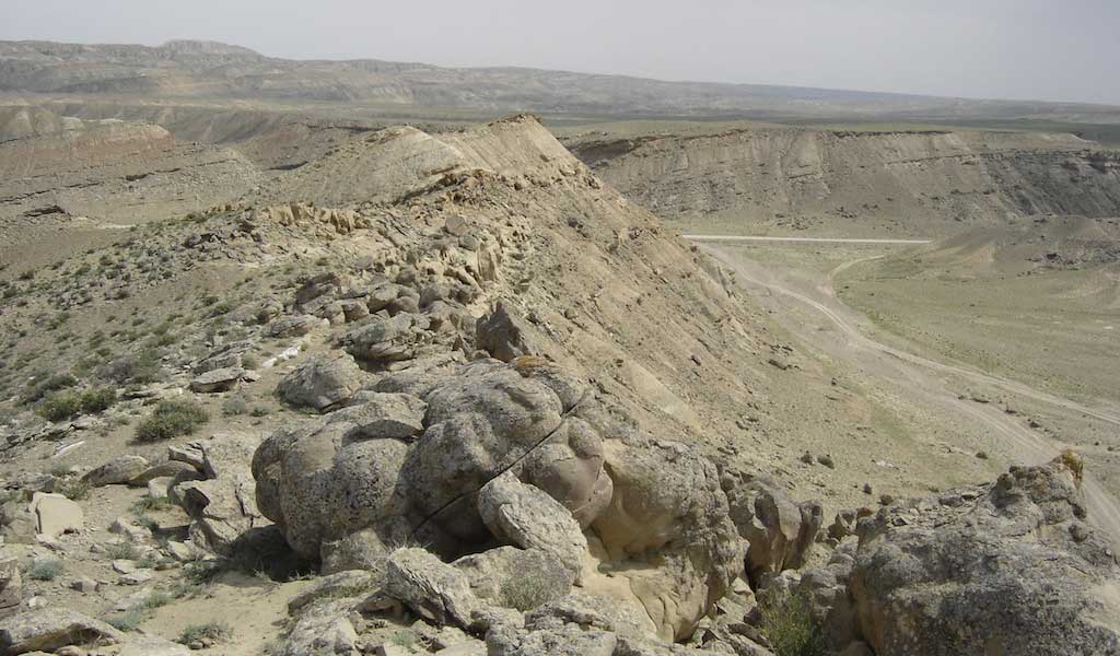
Rising Jurassic sea levels led to a gradual marine transgression. The shoreline shifted across the Central Caspian from south-west to north-east, reaching Mangyshlak in western Kazakhstan during the Bajocian and Bathonian. The fluvio-deltaic to shallow-marine sandstones form major reservoirs in the area, such as in the Uzen field on the northern flank of the South Mangyshlak Basin, with an estimated 8.4 Bbo initially in-place. Such reservoirs are characteristically multi-layered, with the best qualities seen within channelised deposits. Typical reservoir geometries are clearly observed within outcrops in the Karatau hills (Figures 4 and 5).
Jurassic Shelf Carbonates
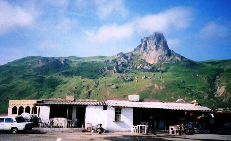
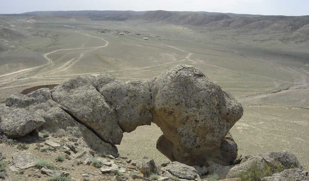
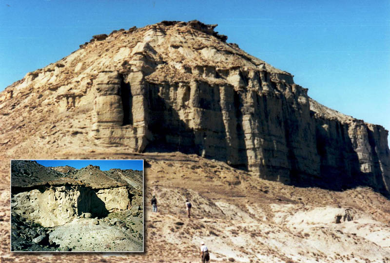 Figure 5: Middle Jurassic of the Karatau hills. The first picture shows Mount Karadiirmen, the type section of the Bajocian-Bathonian Karadiirmen Suite, which is the reservoir for many of the major oil fields of western Kazakhstan. Cemented ‘caps’ (such as that at the summit of the hill, with several more visible in the slopes) represent short-lived periods of sea-level fall during accumulation of this fluvio-deltaic succession (Figure 4). Associated channel incision and later backfilling gave rise to thick channelised sands, such as the 13m thick body illustrated in the inset. Three-dimensional exposures of these Jurassic rocks (and the overlying Cretaceous) can be followed for tens of kilometres, providing excellent examples of reservoir geometry. © Graham Blackbourn.Further sea-level rise during the Late Jurassic led to a shallow-marine shelf extending over much of the Central Caspian region, on which both clastics and carbonates accumulated. Renewed tectonic activity was probably associated with the collision of continental blocks against the Eurasian margin far to the south-east. Relative uplift of the western part of the Karatau rift zone recommenced, with erosion of parts of the Middle Jurassic, although moderately deep-marine Late Jurassic mudrocks are preserved locally in the east beneath the base-Cretaceous unconformity.
Late Jurassic shelf carbonates form an important oil and gas reservoir in Mangyshlak and the Central Caspian. They are not well-developed in the Karatau hills, where the Upper Jurassic is clastic-dominated and affected by numerous unconformities and disconformities, although well-exposed Early Cretaceous limestones provide a fair analogue. Superb exposures of Late Jurassic carbonate-shelf deposits do however occur in the North Caucasus, such as the Skalistyi Ridge in the Baksan valley of the Central North Caucasus, where Oxfordian shelf carbonates are overlain by cliffs of Early Cretaceous (Valanginian) limestone. These exposures were visited by Blackbourn during the early 1990s, although extended visits to the area are now difficult owing to security concerns.
 The Beshbarmak reef is a prominent feature overlooking the coastal road in north-east Azerbaijan. Close examination shows that it comprises an enormous block of an Oxfordian reef, which developed on the northern margin of the Great Caucasus Basin, and later foundered into younger shales during a period of widespread collapse of the basin margins. © Graham Blackbourn.Elsewhere, such as in the Terek-Caspian Basin of the eastern Precaucasus and in the GCB, renewed basin subsidence in a carbonate setting led to the development of basin-fringing reefs. Thick evaporites developed in several of the basins, including Terek-Caspian, and localised evaporites are known in the South Mangyshlak Basin, while the GCB remained a reef-fringed open-marine basin.
Geological research during the Soviet era tended to be compartmentalised within narrow geographical limits. As an example, geologists working in the Caucasus asserted that the huge Jurassic delta-fan system on the north-eastern margin of the GCB was sourced from a (notional) Central Caspian Arch, while Kazakh geologists envisaged the contemporary fluvial system of Mangyshlak as flowing south-westwards into the Caspian Sea. The institutional set-up was not capable of linking these two sets of observations. The wealth of Soviet and more recent geological literature from the local area, with added context and detail from field studies, has enabled the sedimentological and tectonic background to the various petroleum systems of the Greater Caspian region and other parts of the former Soviet Union to be more clearly understood.
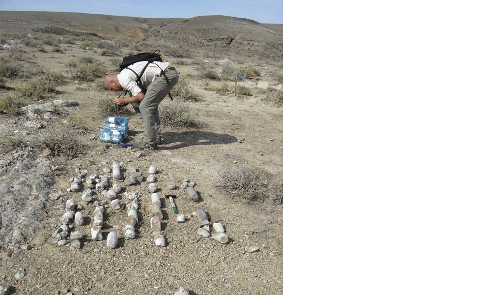
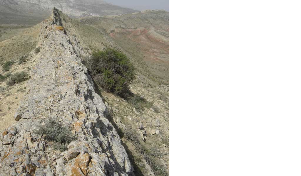
Below is a gallery showing a selection of photographs taken by Graham Blackbourn during the geological fieldwork carried out in the Central Caspian Basin area.
Field work in the Central Caspian Basin area. © Graham Blackbourn.
Field work in the Central Caspian Basin area. © Graham Blackbourn
Field work in the Central Caspian Basin area. © Graham Blackbourn
Field work in the Central Caspian Basin area. © Graham Blackbourn
Field work in the Central Caspian Basin area. © Graham Blackbourn
Acknowledgement
This article is a brief summary of some of the work carried out by Blackbourn Geoconsulting over more than 20 years. In addition to the fieldwork undertaken, it draws heavily on contributions from Russian-language authors, far too numerous to acknowledge here. Conversations with very many clients and co-workers have also been of considerable assistance, though care has been taken to exclude any proprietary information from this account (which would have required some slight adjustments to the maps provided, but not of regional significance). For all of this the author is enormously grateful.
About the Author
Chartered Geologist Dr Graham Blackbourn gained his PhD in sedimentology from Strathclyde University. He has eight years experience within a major UK oil company, where he was the Head of Sedimentology. Dr Blackbourn has particular expertise in relating petrography to petrophysical properties and reservoir quality. Dr Blackbourn has published many papers on sedimentology, specialising in marine clastics, continental ‘red bed’ facies and diagenesis in clastic reservoirs. He has worked extensively on the relationship between petrographic properties and reservoir quality.


