Hidden assets: South Australia
A largely untested 15,000 m of syn-rift and post-rift succession of Middle Jurassic to Upper Cretaceous sediments in the offshore Ceduna Sub-basin beckons exploration.
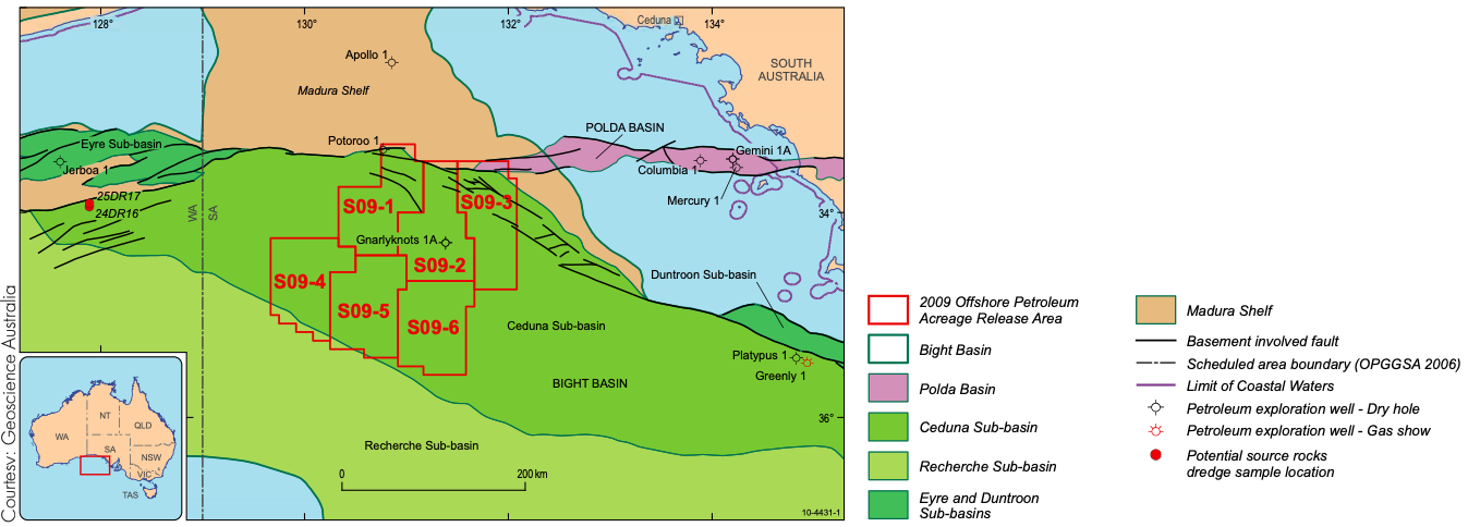
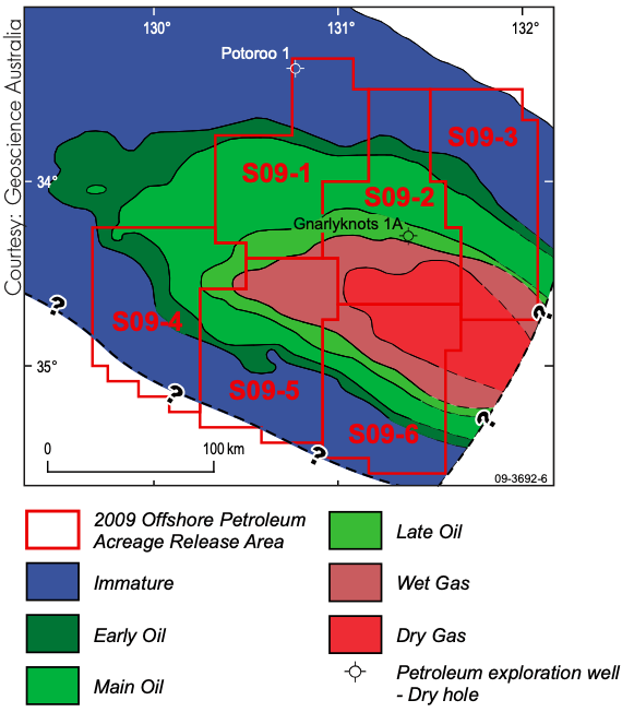
This year the Australian Government is offering six exploration areas in the frontier Ceduna Sub-basin of the Bight Basin. Prior exploration focused mainly on the margins of the Ceduna Sub-basin where nine unsuccessful wells were drilled. The only well that attempted to test the deep basin was drilled in 2003; the Gnarlyknots 1A well targeted an untested petroleum system but failed to reach the planned horizons.
In 2007, after the first wave of unsuccessful exploration, and to address questions concerning the area’s petroleum prospectivity, Geoscience Australia conducted a marine sampling survey. This survey identified rich Late Cretaceous source rocks in the basin. A recently completed seismic survey, BightSPAN™, conducted by ION Geophysical, was able to image an early rift section much more clearly than previous datasets. The deep imaging, regional survey shows untested potential petroleum systems to underlie most of the basin.
Basin expectations
A series of Mesozoic to Cenozoic depocenters developed along Australia’s southern margin during the breakup of eastern Gondwana. Prior to and following the commencement of seafloor spreading between Australia and Antarctica, basin development evolved through a series of extensional and thermal subsidence episodes. The result is the east-southeast trending Ceduna Sub-basin, the major depocenter in the Bight Basin. The Sub-basin extends over an area of 126,000 km² in water depths to 4,600 m.
“After the first round of exploration, one of our biggest concerns about the Ceduna Sub-basin was the existence and extent of source rocks,” says Jennifer Totterdell, Project Leader for the Southern Frontiers Project, Geoscience Australia. “Negative perceptions regarding the prospectivity of the Bight Basin followed the disappointment of Gnarlyknots 1A, and one of the perceived exploration risks in the basin continued to be hydrocarbon charge.”
“Previous work based on wells that intersect the proximal basin margins identified a range of potential source rock intervals across the basin, with the most prospective section predicted to be the more distal, marine facies of the Albian-Santonian section,” says Jennifer. “In 2007, we successfully sampled more distal rocks along submarine canyons and fault exposures. We found the best source rocks to date, a suite of organic-rich, oil-prone shales of Cenomanian-Turonian boundary age.”
According to Geoscience Australia, subsequent petroleum systems modeling showed that generation and expulsion from the Cenomanian–Turonian (Late Cretaceous) source rock occurred during the mid-Campanian to Recent, resulting in potentially significant accumulations of both liquid and gaseous hydrocarbons within overlying deltaic sandstones of the Turonian–Santonian Tiger and/or latest Santonian–Maastrichtian Hammerhead supersequences.
Key survey
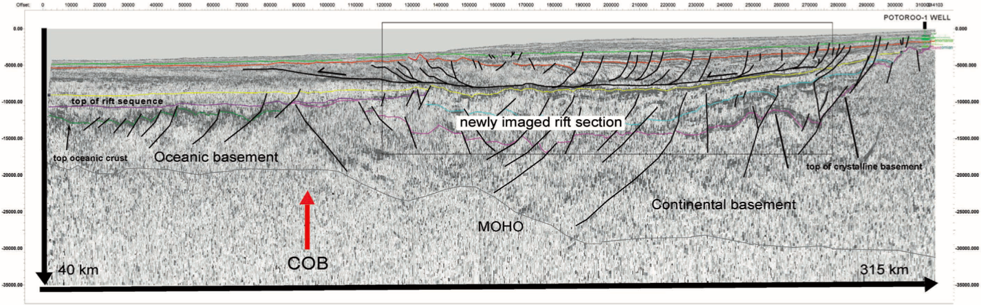
The BightSPAN program covers a portion of the Bight Basin and particularly the Ceduna Sub-basin where Australia is offering tracts for leasing. The acquisition is typical of other ION BasinSPANS™ programs. The seismic data are interpreted together with simultaneously collected gravity-magnetic data to regionally map the crustal continent-ocean boundary (COB) and the top of the MOHO discontinuity.
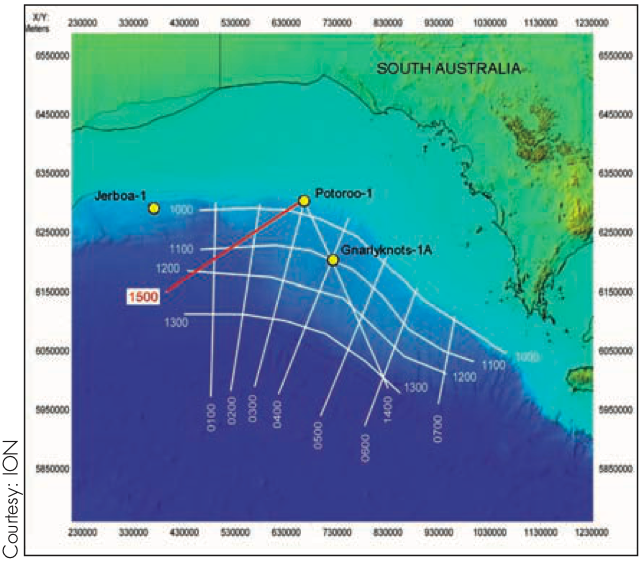
Line 1500 extends from the outer continental shelf from the Potoroo-1 well, across the COB, and out over the ocean crust. Oceanic crust (top shown in green) lies in about 5,000 m water depth, is characterized by about 6 or 7 km of crystalline crustal thickness and a MOHO at about 15 km depth. The COB lies near the base of the continental slope, where MOHO begins to deepen from the base of oceanic crust to beneath the continental shelf.
The placement of the continental basement (top shown in pink) and MOHO picks is crucial to understanding the petroleum systems of this margin as it controls not only the thickness of rift-related sedimentary rocks but also the age of the critical points in the petroleum history. The Potoroo well bottomed in basement and helps anchor that pick. ION’s interpretation is further controlled by modeling of the gravity profile taken during acquisition and verified by two seismic refraction experiments reported by Hayes in the 1991 AGU Circum-Antarctic Atlas.
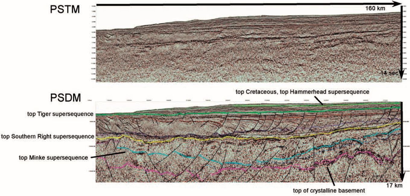
The sedimentary section of the line consists of a thin Tertiary section above a Cretaceous section that has been previously imaged in seismic data, down to about the top of the Southern Right supersequence (shown in yellow) which has, in some previous surveys, been interpreted as the basement. A rather typical continental margin growth fault system balanced by a toe thrust lies just above the yellow horizon.
Below the Southern Right supersequence, or prior to the Berriasian, is a section at least 5 km in thickness above basement that developed during the early rifting phase between Antarctica and Australia. In previous datasets, this has only been poorly imaged if imaged at all.
Untested petroleum systems
The petroleum system identified by Geoscience Australia from seafloor dredge samples lies in the upper portions of line 1500. The marine source rocks identified to be the best found to date lie below the bright green horizon (top Tiger supersequence or top Santonian) and above the red horizon (Blue Whale supersequence). Potential hydrocarbon accumulations are predicted to occur in the deltaic sandstones near the top of the Tiger supersequence. Reservoir sandstones are also found in the overlying Hammerhead supersequence located below the top Cretaceous pick (dark green horizon).
The older rift section (between top Basement shown in pink and Southern Right shown in yellow on the time-depth line) that is imaged on the inboard BightSPAN data is interpreted to be equivalent to the fluvial-lacustrine Middle Jurassic-Early Cretaceous section intersected in the Eyre Sub-basin to the west (Sea Lion and Minke supersequences). It is overlain by an Early Cretaceous succession that is largely non-marine and which is interpreted to include thick lacustrine shales. In the Eyre Sub-basin, the early rift succession is interpreted to contain lacustrine source rocks that have sourced the breached oil accumulation at Jerboa 1, the only well in the Eyre Sub-basin.
“New seismic data, including the BightSPAN survey and reprocessed data available from Geoscience Australia and Fugro MCS, provide clearer imaging of the Jurassic half graben along the eastern margin of the Ceduna Sub-basin and new insights into the half graben play in this part of the basin,” says Jennifer Totterdell.


