Sharper imaging, smarter exploration
How cutting-edge seismic techniques are transforming risk assessment in the GOA
Since 2019, long-offset Ocean Bottom Node (OBN) technology has become a cornerstone for advanced imaging in the GOA, providing clearer views of subsurface structures that help reduce drilling risks and improve prospect evaluation. Recent Amendment surveys by TGS and SLB demonstrate the power of pairing long-offset OBN with next-generation processing techniques, delivering cleaner images that enhance structural interpretation and stratigraphic mapping.
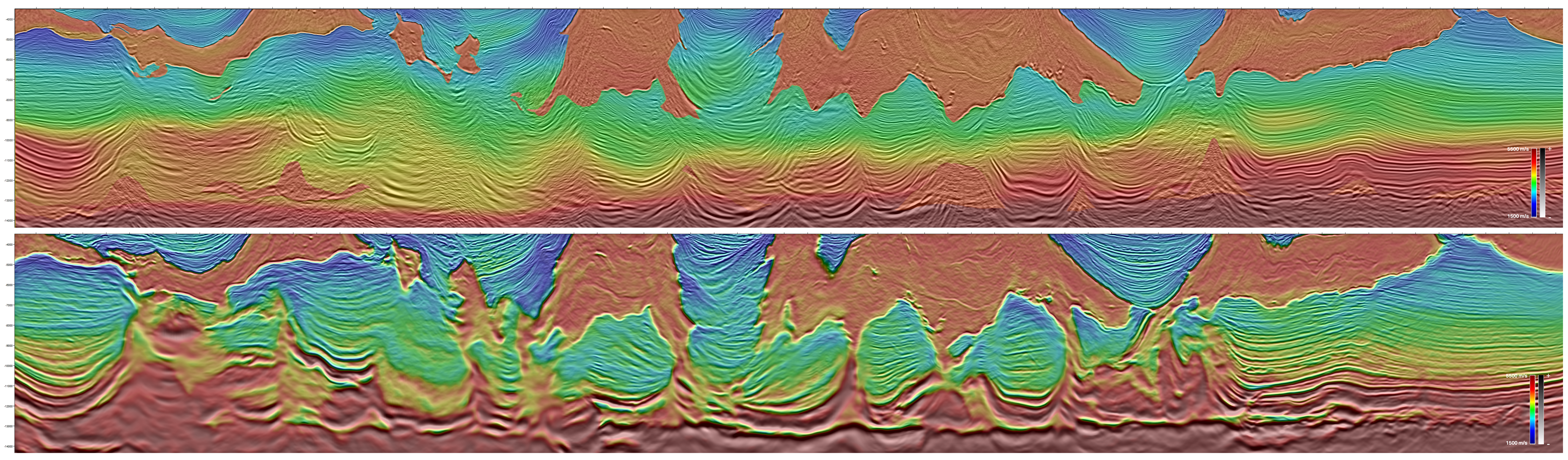
Elastic Dynamic Matching Full Waveform Inversion (E-DMFWI) Derived Reflectivity (FDR) further sharpens this lens, addressing illumination challenges beneath salt canopies while improving reflector continuity and the clarity of salt-sediment interfaces (Figure 1). These advances are critical for identifying and de-risking salt-related traps and improving the predictability of reservoir presence, quality, and continuity.
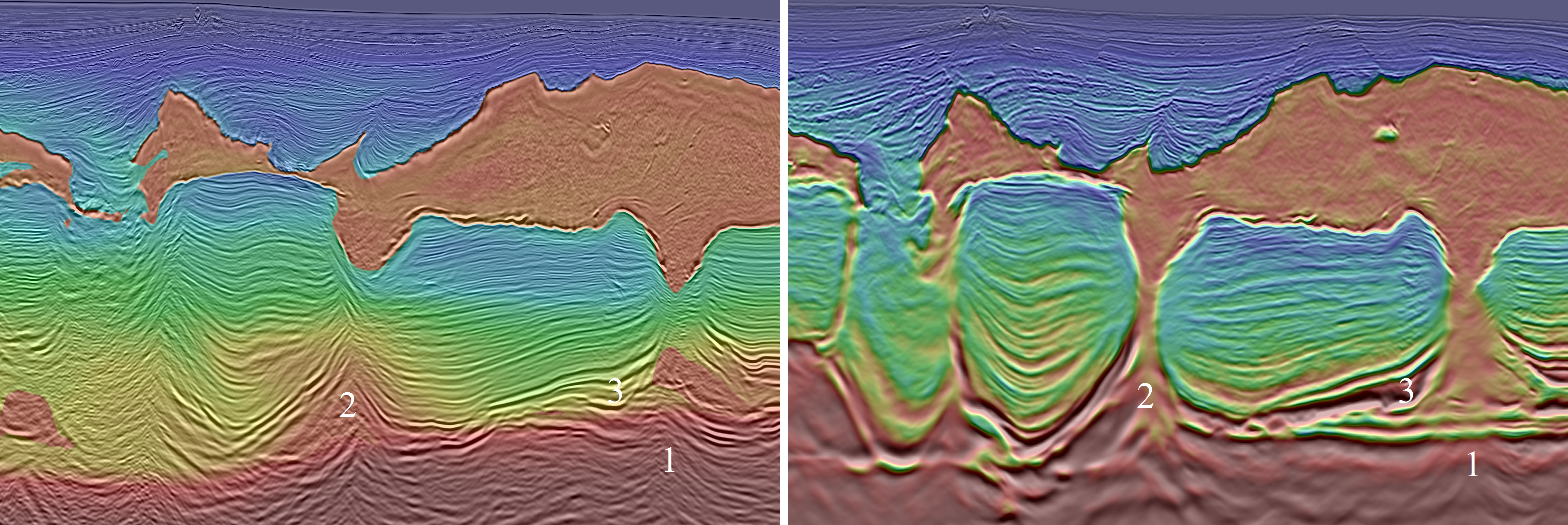
High-resolution imaging now extends from the basement to the seafloor (Figure 3), offering unprecedented clarity of geological structures. This leads to a deeper understanding of tectonic history, including the identification of previously obscured fault systems and structural boundaries. Enhanced delineation of deep carbonate formations – marking the base of the prospective Miocene section – improves our understanding of regional salt tectonics and sediment pathways. Additionally, clearer imaging of salt body geometry allows refined interpretations of depositional environments and bypass zones, which are essential for predicting reservoir quality and continuity.
Building high-fidelity velocity models
High-resolution seismic imaging relies on a robust, accurate velocity model. Using FWI workflows, these models now capture the complex velocity contrasts associated with salt geometry and subsalt sediments, reducing structural uncertainty in depth imaging. This enables better identification of source rock intervals and highlights the influence of basement topography on the deposition of organic-rich sediments, often linked to productive hydrocarbon source rock.
Gemini: Low-frequency powerhouse for deep imaging
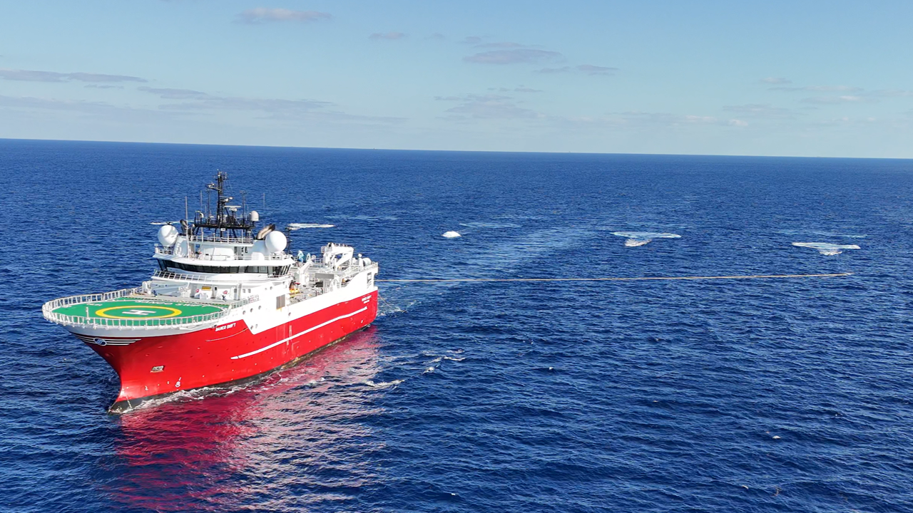
To maximize the value of long-offset OBN, low-frequency energy is key. Enter Gemini, TGS’s advanced low-frequency source technology designed to enhance deep imaging and feed low frequencies essential for FWI convergence. Generating energy down to 1 Hz, Gemini represents an environmentally enhanced approach to seismic source design, delivering low frequency signal at very long offsets and extending the subsurface reach of surveys across the deepwater Gulf.
Its operational simplicity, towing four Gemini sources on a single vessel (Figure 4), and its point-source design streamline data processing while reducing HSE exposure, improving operational efficiency and reliability, and simplifying handling, all while maintaining high data quality. By enabling a broader, deeper bandwidth for imaging, Gemini helps unlock the potential of underexplored plays within complex salt provinces.
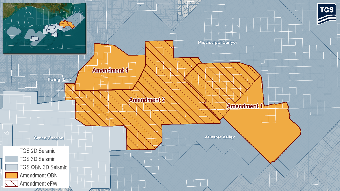
Amendment 4: A transformative step forward
TGS’s Amendment 4 project in the Mississippi Canyon (Figure 2) is a showcase of what happens when cutting-edge technology converges. By combining Gemini low-frequency source technology with long-offset OBN acquisition and E-DMFWI processing, Amendment 4 delivers a premium seismic product designed to illuminate complex subsurface features from the shelf to the slope. This approach positions operators to better understand challenging structures, refine drilling targets, and reduce exploration risk.
Driving toward the future
The Gulf of America’s potential is tied to our ability to see deeper and clearer beneath complex salt bodies and deepwater sediments. As exploration activity moves westward into areas with higher geological complexity, adopting advanced seismic tools like long-offset OBN, Gemini low-frequency sources, and E-DMFWI becomes essential for finding the next wave of reserves. These innovations not only advance the science of seismic imaging but also contribute directly to US energy security and economic growth by enabling smarter, more successful exploration campaigns.
By investing in these technologies today, the industry is building the foundation for tomorrow’s discoveries, ensuring the Gulf of America remains a cornerstone of sustainable, reliable energy supply for years to come.


