But what exactly is AGG, how does it work, and why has its application become an essential component of any exploration programme? We will try to explain it by sharing a bit of history of the development of this technology from its origins to the most recent advances.
AGG – A long development history
Since the introduction of the torsion balance in the 1890s, it has been recognised that gravity gradient information is very valuable, yet difficult and time-consuming to obtain. Baron Loránd von Eötvös developed the first torsion balance instrument for field use with an accuracy of 10–9 per sec2 (this CGS unit ultimately received the name Eötvös or E). The only problem was that the measurements were very time consuming. Improvements in torsion balance design led to the introduction of the Oertling and Askania torsion balances in the 1920s, with similar accuracy as Eötvös’s early instrument, only smaller in size.
Until its discontinuation in the late 1930s, the torsion balance contributed to the discovery of 79 oil fields in the Gulf coastal region of Texas and Louisiana. It is estimated that these fields contained petroleum reserves of approximately one billion barrels. Unfortunately, torsion balance field surveys were laborious and expensive. The instrument had to be housed in an insulated portable hut to reduce temperature variations while mounted on an aluminium baseplate for stability. Readings were required at three instrument orientations, at 120-degree intervals, with one orientation repeated. After each rotation, one hour was required for the beams to stabilise before readings could be made. A total of four hours were required at each measurement location or station. In 1930, about 125 of these instruments were in use in oil exploration worldwide. These became obsolete, not because they produced inferior results, but because the operational challenges were so great, and the use of spring gravity meters were easier and more efficient for the field operator.
Fast forward to the 1970s when the need for gravity gradient measurements re-emerged – not for exploration purposes, but for assisting with missile launch and navigation functions. The US Air Force and US Navy and Ballistic Missile Defence Organisation (BMDO) all recognised the benefit of being able to make moving-base measurements of gravity gradients. The result of this interest was the deployment, in the 1980s, of the Gravity Sensors System (GSS) for the US Navy Fleet Ballistic Missile Submarine (Trident II) Navigation programme and the Gravity Gradiometer Survey System (GGSS) for the Air Force Geophysics Lab (AFGL). These systems incorporated the Bell Aerospace (now Lockheed Martin)-designed gravity gradiometer systems using full-tensor gradiometers (FTG) which measured all the independent gravity tensor components with accelerometers housed in three discrete instruments.
Commercial uses for the gravity gradiometer came to the forefront in the early 1990s, when Bell Geospace Inc. (BGI) conducted the first Gulf of Mexico marine hydrocarbon surveys using the US Navy ship USNS Vanguard – and its installed FTG gravity gradiometer system. These surveys, which began in 1994, demonstrated the ability to collect meaningful gradiometry data from a moving marine platform.
BHP sees sotential
At the same time, BHP engaged in an R&D effort with Bell/Lockheed Martin to develop a unique gravity gradiometer system for mineral exploration applications (e.g., diamonds). The intention was to build the next generation of equipment – one that would be a game-changer in resource exploration. The project began with a thorough investigation of existing exploration techniques and equipment. The one that showed the most promise was gravity gradiometry and the equipment was the FTG built by Lockheed Martin. BHP knew there were limitations for the technology when deployed on an aircraft. The dynamic airborne environment is orders of magnitude more turbulent than that of a submerged submarine. This vertical acceleration causes significant errors in the FTG data that vary based on the level of turbulence. BHP understood that they did not need to measure most of the tensor components to determine all of them. With this understanding, the joint development project with Lockheed Martin focused on modifications that would dramatically decrease noise and increase repeatability. The first modification was to move to a near-horizontal disc on which to mount the accelerometers. This change significantly reduced the impact from vertical acceleration caused by turbulence.
Falcon™ Takes Flight
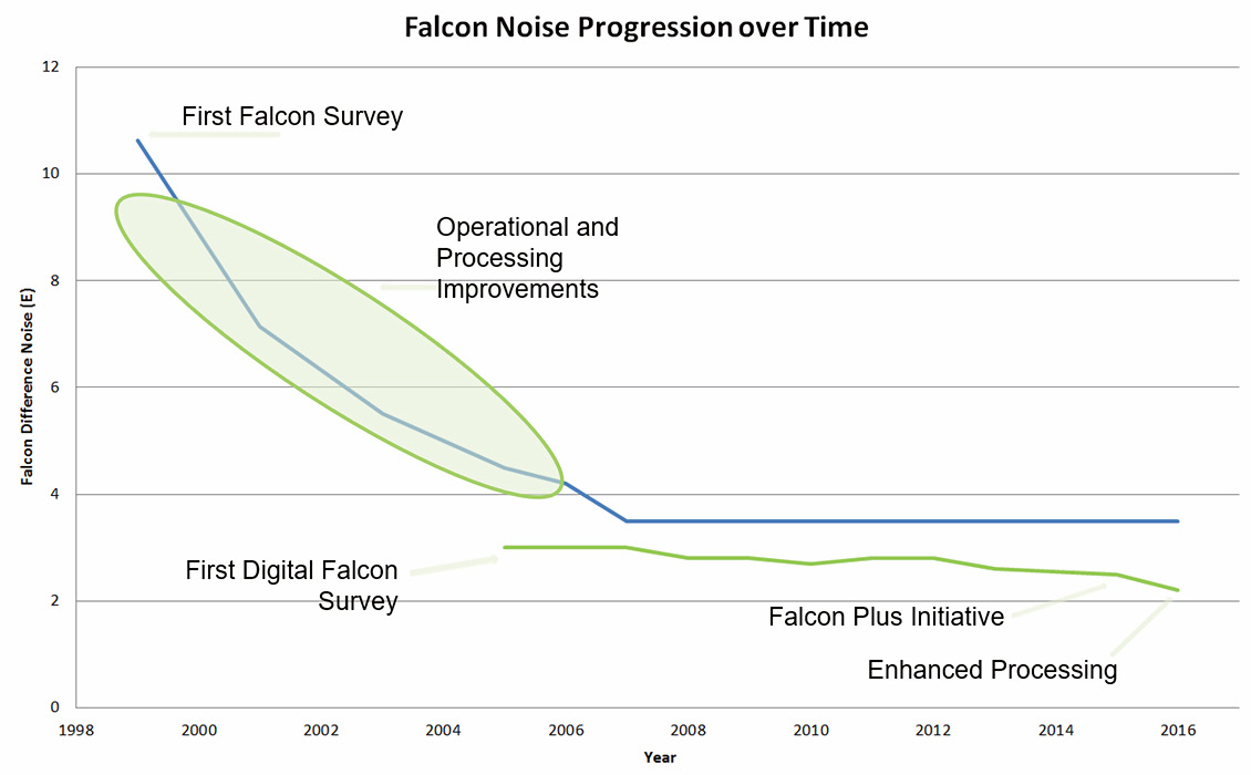
BHP trademarked this design Falcon™. The results showed near-constant noise levels from the Falcon systems at all levels of turbulence. The next major modification was to build-in a second set of accelerometers, as well as increasing the sensor separation distance (baseline), to reduce noise further. This enabled the design to yield two near-independent gradiometers in one instrument. This allows for every data point to be a repeatability measurement. These changes allowed BHP to improve the gradiometer into a revolutionary exploration tool for mineral exploration. During their exclusive ownership of the equipment, they acquired nearly 2,000,000 line-km of exploration data. They made countless discoveries until they exhausted all their mineral properties. BHP then divested the technology to Fugro Airborne Surveys, and subsequently to CGG. Xcalibur Multiphysics is now the proprietor of this technology. Numerous improvements to the Falcon systems over the past 25 years have yielded significantly better operating performance. These include Falcon Plus: a digital design which improves upon the original analogue functionality of Falcon (this was first deployed in 2005); Heli-Falcon: installation of the digital Falcon into a B3 helicopter for lower and slower data collection surveys yielding higher resolution data; and Full Spectrum Falcon: an integrated system that melds the inputs from the gradiometer with an on-board gravimeter to assess all wavelengths of interest.
In addition to improvements noted for the Falcon systems, Lockheed Martin also embarked on an ambitious design called the Enhanced FTG (eFTG) that included the best features of Falcon integrated into a full-tensor configuration. This larger, more capable system is currently deployed by Austin Bridgeporth for airborne surveys. Lockheed Martin remains the sole commercial supplier of gravity gradiometer systems (e.g. Falcon, FTG and eFTG) to the resource exploration industry.
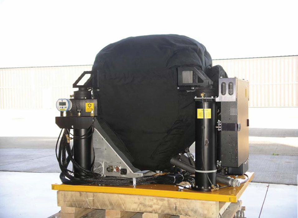
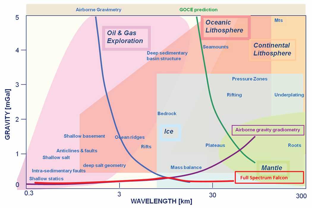
Both airborne gravity (AG) and AGG systems (Figure 1) measure derivatives of the gravity potential. While the noise in AG-acquired vertical gravity data decreases as wavelength increases, the noise in AGG-acquired vertical gravity increases as wavelength increases. Figure 3 illustrates the relationship between noise and wavelength for AG, AGG and satellite gravity. The optimal combination of both AG and AGG data can result in high quality gravity data with low noise across the entire acquisition spectrum.
The Falcon AGG system, after its initial development by BHP, has been progressively improved over the last two decades with the many enhancements described above. Most recently the industry recognised the need to measure both short and long wavelength to improve the detection of the wide bandwidth gravity anomalies of geological interest. It is to fulfil this need that equipment like the Xcalibur’s sGrav (gravimeter), measuring AG, has been developed and deployed simultaneously with the Falcon AGG systems.
Each dataset is processed separately to obtain vertical gravity. For the AGG data, vertical gravity is derived from the measured gradients either via integration in the Fourier domain or an equivalent source process. For the AG data, standard gravity processing methods are used to obtain the vertical gravity. With the AG and AGG vertical gravity products, error curves for AG and AGG are derived as a function of wavelength as illustrated in Figure 3.
These two error curves allow the determination of the ideal cross-over wavelength. Plotting these estimated errors together allows the visualisation of results to find the wavelength at which the two error curves intersect. The wavelength at this intersection is the ideal cross-over point for merging the AGG and AG gravity. Once the centre wavelength of cross-over filters is determined, the two datasets are merged to obtain the optimal dataset of low noise, wide bandwidth gravity.
Victoria (Australia) case study
To demonstrate the result of the combination of AG and AGG we show data examples from a recent survey flown for the Geologic Survey of Victoria in Australia. The survey covered an area of about 15,000 km2 at a line spacing of 500m along the southern coast of Victoria. Both AGG and AG data were collected at the same time on the same aircraft. The AGG system was a Falcon AGG and the AG system was an sGrav. From these two datasets, it is possible to estimate the AGG and AG gravity errors to determine the optimal cross-over wavelength to merge them.
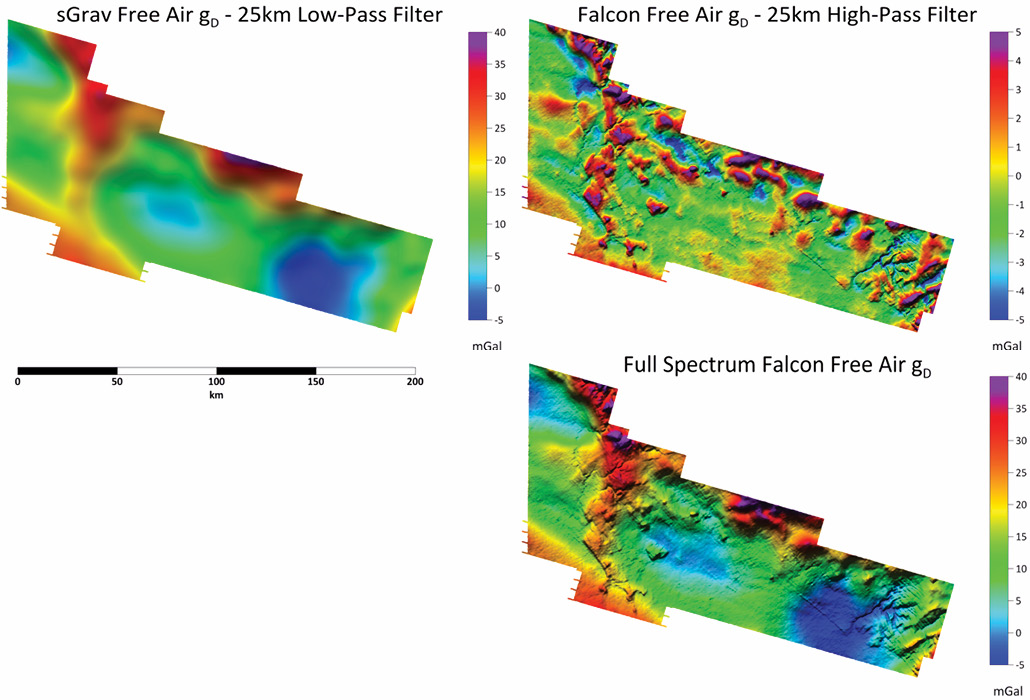
Using a 25 km cross-over wavelength, the sGrav data (after application of a low-pass filter) and Falcon data (after application of the high-pass filter) were added together to create the Full Spectrum Falcon product. These results are shown in Figure 4. The noise estimate for this survey was 0.3mGal.
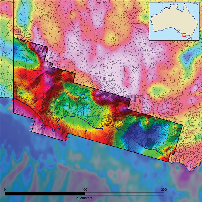
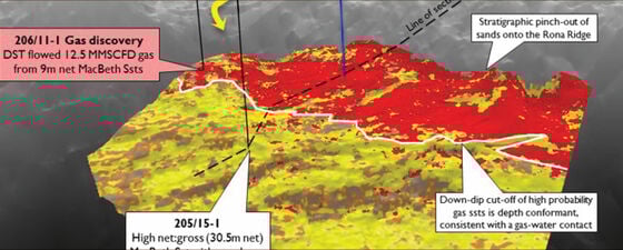
The survey was acquired as part of the ‘Victoria Gas Program’ and covered both onshore and offshore regions, providing full coverage across the transition zone where little or no other data had been acquired. The resulting anomaly map (Figure 5) clearly shows both deep basement structures, where the sedimentary sequence is thicker, as well as more subtle intra-sedimentary or shallow geological structures.
Since the initial deployment of AGG, there has been a continuous improvement of data quality as a result of both equipment development and processing techniques. The acquisition of data covering the full spectrum of geological responses of interest has been of increasing importance for oil and gas exploration. Collection of the highest quality vertical gravity data across a broad bandwidth is best done by utilisation of both a conventional AG and an AGG system. Each of these system types has its advantages and weaknesses, but together they make a powerful exploration tool.