Outer Vøring Basin – what is required?
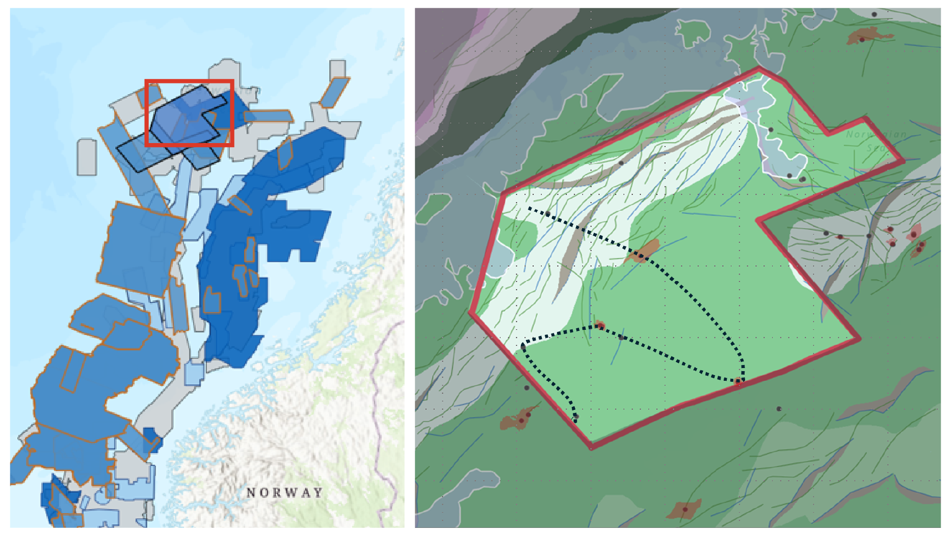
To unlock the prospectivity of the Outer Vøring Basin, TGS has acquired ~10,000 km2 of GeoStreamer multisensory broadband data using a wide-tow triple source configuration and two long tails for FWI (full-waveform inversion) processing. This new dataset is the latest piece of the comprehensive TGS Atlantic Margin data library, covering the Faroe Shetland Basin to the Norwegian Sea.
During the last decade, there has been a shift to larger 3D surveys, which is important for the new geological understanding. From 2017 to 2020, TGS acquired more than 55,000 km2 in the Møre and Vøring basins, providing new insight and knowledge of the prospectivity along the whole mid-Norwegian continental shelf.
The PGS23M02NWS addition to the Atlantic Margin is a high-quality GeoStreamer volume which combines multisensory broadband and wide-tow triple source efficiency with the latest processing technology and velocity model building to improve the subsurface imaging, its complexities and potential. Pre-stack depth migration (PSDM) combined with full-waveform inversion (FWI) makes a major difference for the interpretation and mapping of hydrocarbon deposits and for discrimination between volcanic rocks and sediments .
Geological setting and opportunities
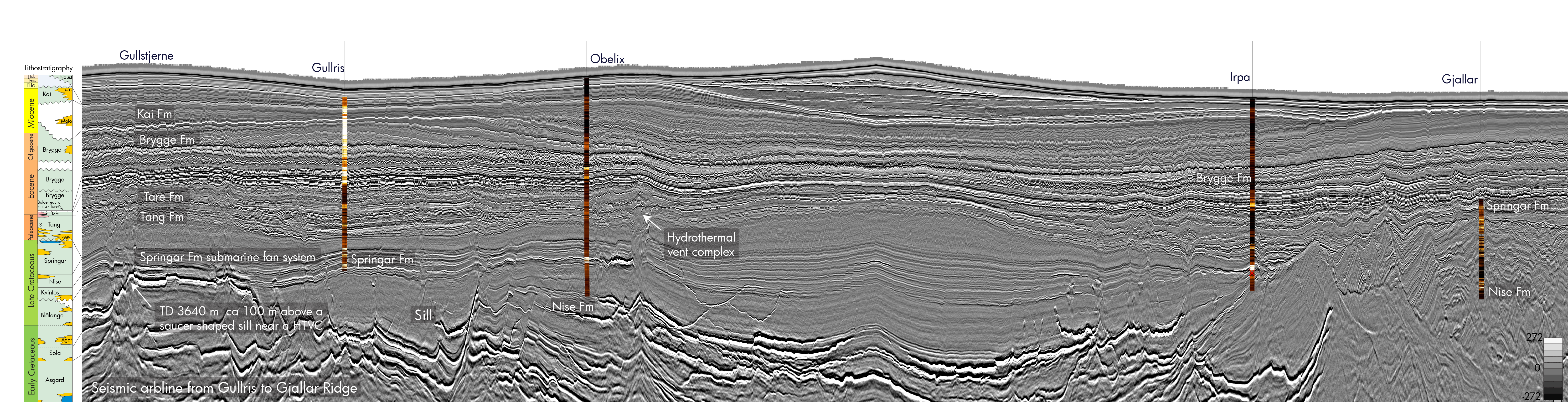
For more than three decades the Outer Vøring Basin has been explored, experiencing increasing or decreasing industry interest depending on recent well results and resource estimates. The area was without infrastructure, and it took 21 years before the 1997 Luva discovery, now a part of the Aasta Hansteen Field, to come online in 2018 after the construction of the Polarled pipeline. Recent discoveries such as the Obelix Upflank (2023) and Haydn (2024) have again spurred interest in the area potentially extending the life of Aasta Hansteen by seven years. Besides the infrastructure in place, what other factors have changed to renew the industry interest?
“Norwegian gas is in high demand and is crucial to Europe’s energy security. That’s why it’s important for us to continue exploring and making new discoveries so we can maintain a high level of deliveries” (ref: Equinor).
Another important factor contributing to the change of exploration interest in the area could be the cooperation between academia, petroleum companies, and the government in joint research projects, leading to the publication to new geological models and research results. The Paleogene continental breakup and ocean formation is an important event in this geologically complex area, as it impacted the sedimentary systems going from shallow to deep marine environments with bottom currents and sedimentary drift deposits. To further improve the exploration success in the Vøring Basin, an understanding of the volcanic margin deposits and processes is essential. Short-term effects of the magma emplacement included deformation, uplift, heating of host rock, petroleum maturation and differential compaction. The recent results from the IODP Expedition 396 drilling campaign in 2021 may provide new documentation and constrain on the Paleogene breakup magmatism which should be beneficial for the explorationists working in this area.
The Gjallar Ridge, covered by the PGS23M02NWS, was a large pre-breakup structure. Sand sourced from Greenland may have crossed the Vøring transform margin to the Vigrid Syncline and Fenris Graben.
With new high-resolution seismic data, interpreters will be able to map and explore in detail the deep-water source-to-sink sedimentary systems related to the Paleocene-Eocene Thermal Maximum.
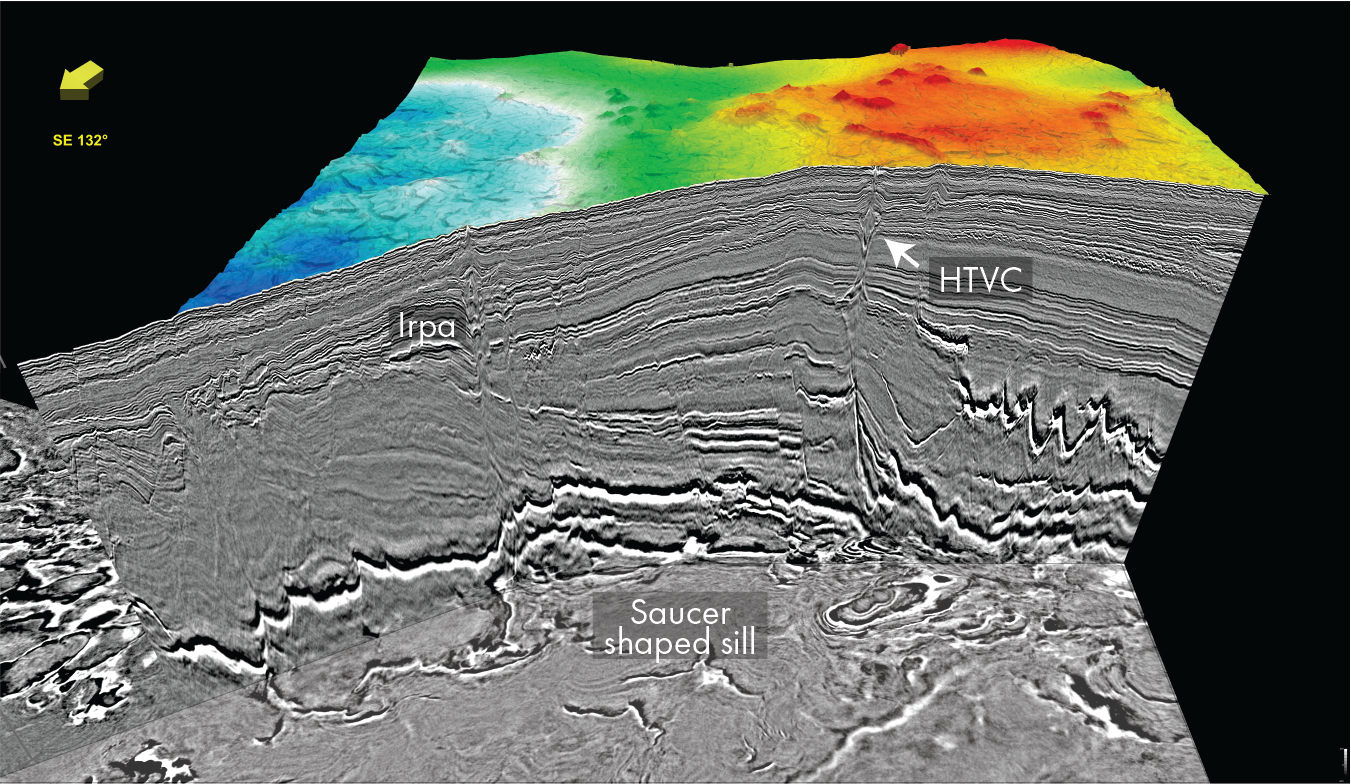
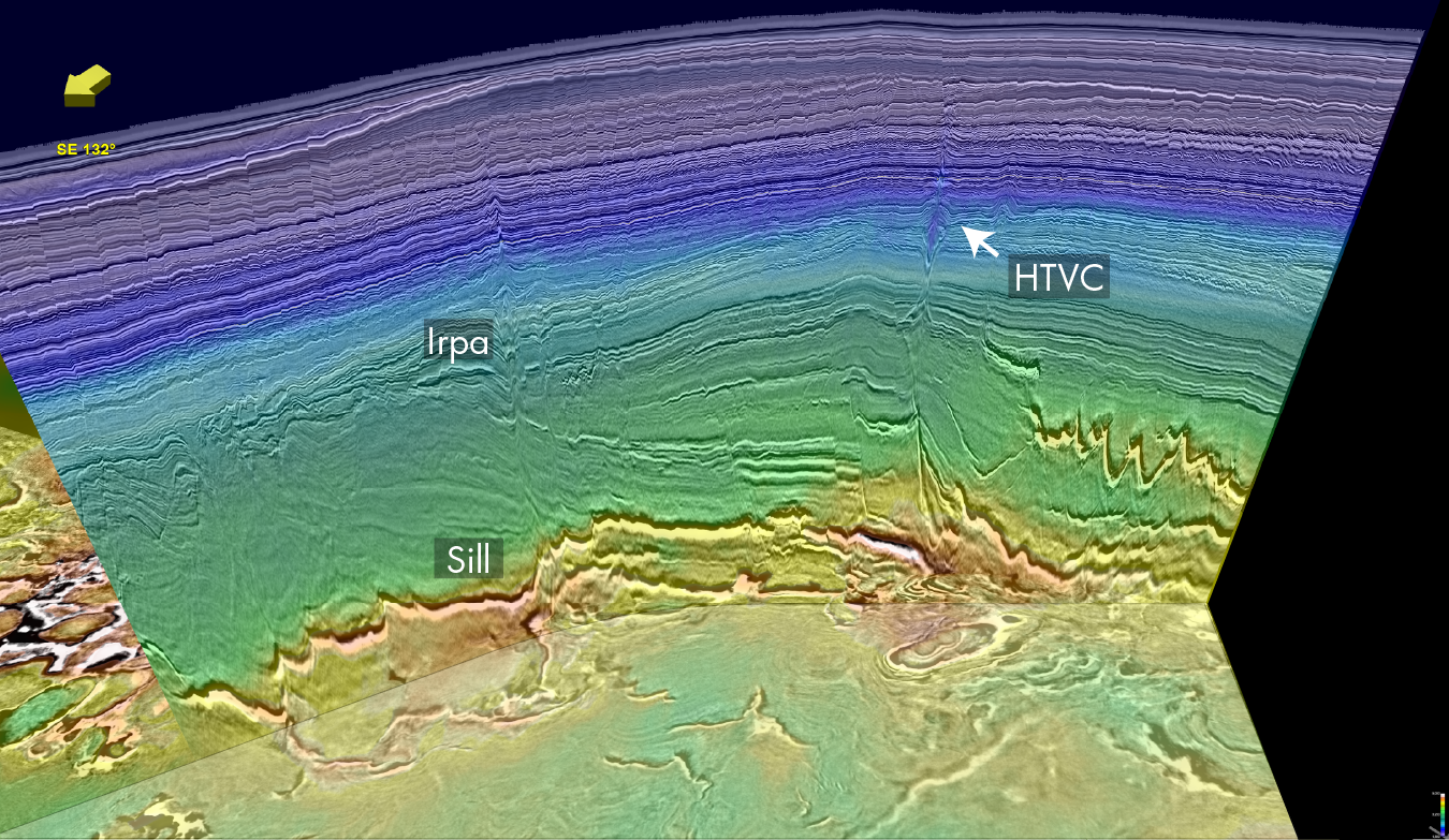
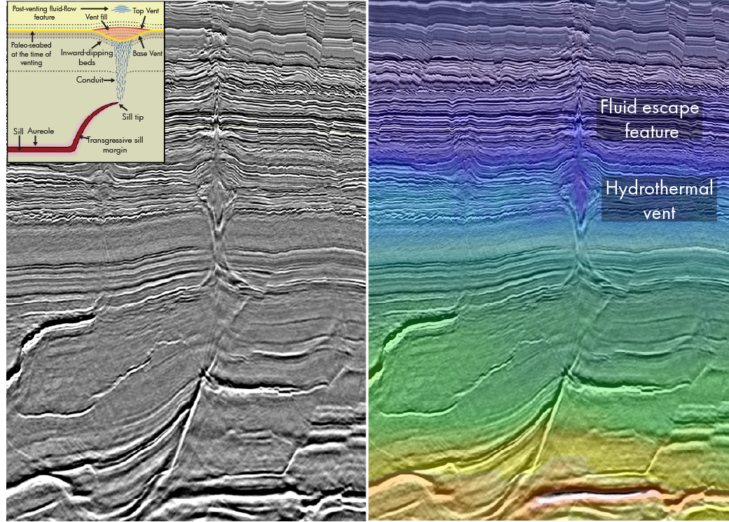
Over the last decade, more than 800 hydrothermal vent complexes (HTVC) have been identified in the Vøring Basin, and some of them studied in great detail. A schematic from Manton et al. (2022) is shown in Figure 2. These studies have led to a better understanding of their formation and long-term impact on fluid migration and petroleum systems. The vent complexes were formed due to pressure build-up in metamorphic aureoles around the hot magma intrusions 56 millions years ago, mainly by explosive eruption of gases, liquids and sediments, forming craters at the seafloor. Most of them are located at the Top Paleocene level (Planke et al., 2004). The conduits between the sills and the vents are important for fluid-migration and potential for hydrocarbon migration from deep structures to shallower reservoirs. Mounds and seismic seep anomalies located above the hydrothermal vent complexes suggest that they have been re-used for fluid migration long after their formation. (Manton, et.al., 2019). Internal structures of the vent complexes are now possible to interpret in detail on the new data and will contribute further to the knowledge of these.
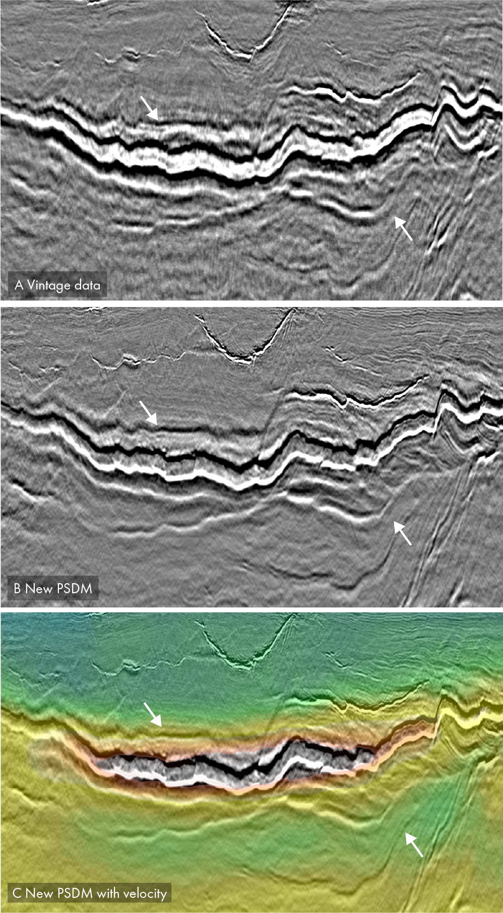
Sills display a large variation in geometries and sizes and the emplacement processes lead to complex geometries in the Vøring Basin. Sills can vary from a few meters in thickness to a couple of hundred meters and they are observed to merge into one or split into several sheets. They may clearly impact both seismic imaging and potential hydrocarbon reservoirs, The intrusive sill complexes can more easily be recognized and risk-evaluated on the new seismic data. Deep sills which were poorly imaged on vintage data can now be mapped with high confidence and supported by velocity contrast as seen in Figure 3. The new data are crucial input for basin and reservoir modelling and can facilitate de-risking of prospects.


