Turning archives into insight
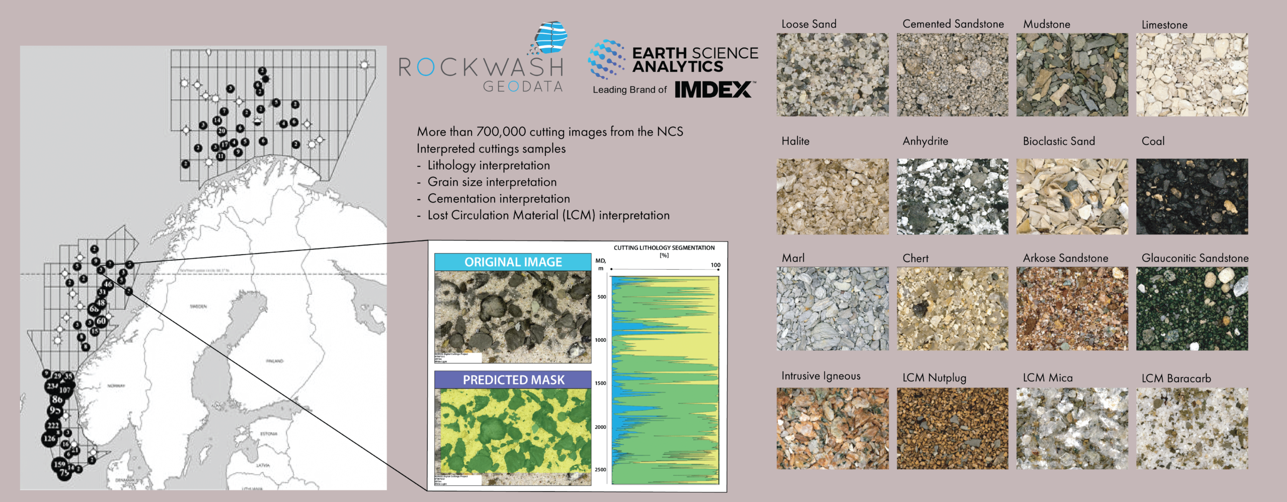
The goal is simple: Make geological cuttings not just visible, but actionable (Figure 1). Traditionally stored in boxes and rarely re-examined, these samples record the geological history of every drilled well. Now, through AI-enabled digitisation, 718,663 cutting samples from the Released Wells Initiative (RWI) operated by NOROG have been standardised and interpreted for lithology, grain size, cementation, and lost-circulation material (LCM).
Machine learning in action
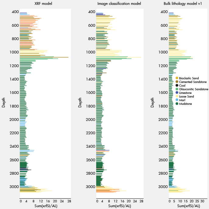
Multiple machine-learning models work together to extract complementary insights from each cutting sample (Figure 3). Image-classification models analyse sample photographs to identify lithologies such as sandstone, shale, limestone, and mud additives such as LCM.
Trained on thousands of annotated examples, they deliver consistent results, while bulk-annotation tools in EarthNET AI Images accelerate labelling and retraining.
Outputs from both models are merged through a rules-based workflow that combines image and chemical probabilities to select the most likely lithology, significantly reducing misclassification and improving consistency across.
Seeing inside each sample
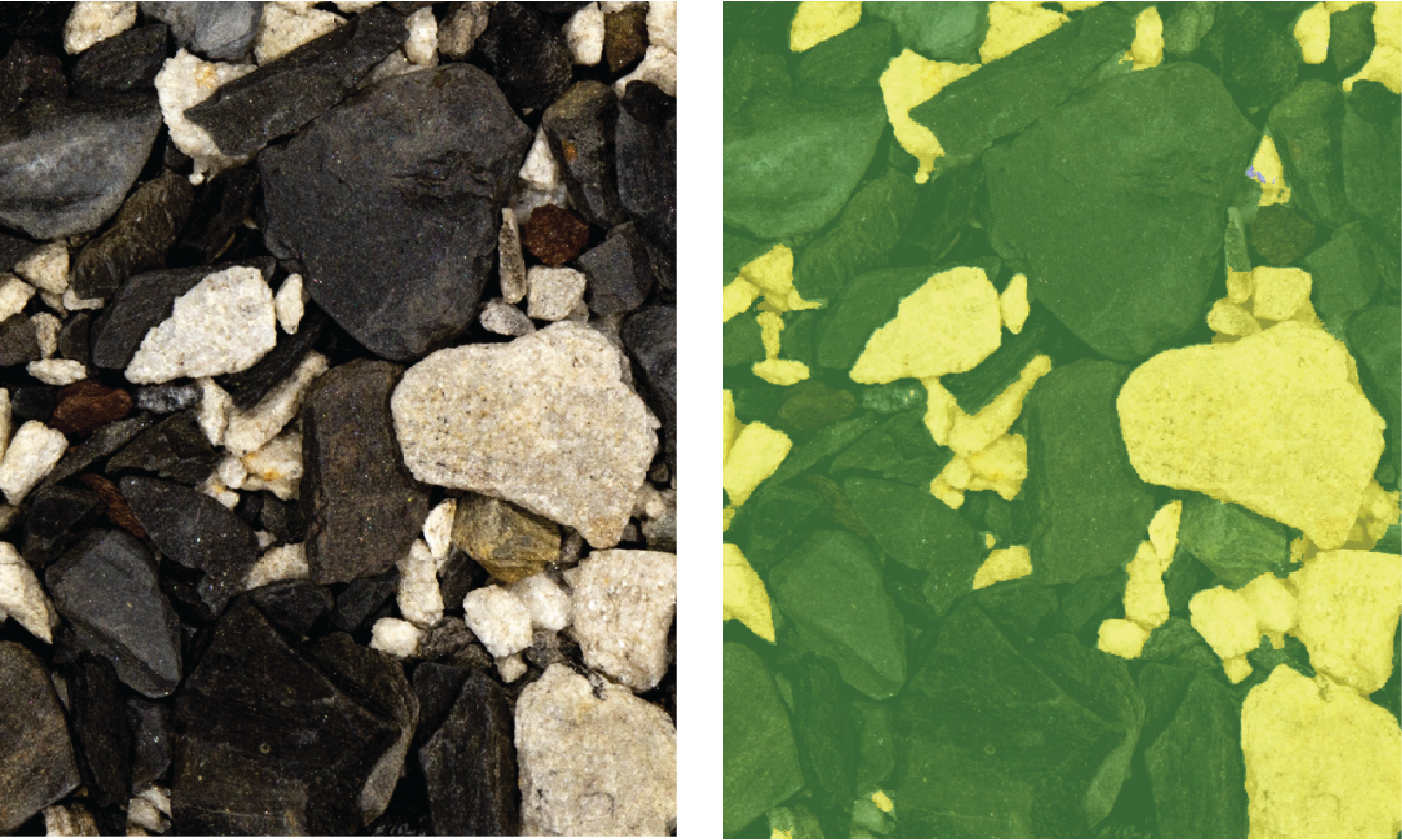
Beyond classification, semantic segmentation maps each pixel by lithology, quantifying mixed samples and revealing how multiple materials coexist within a single image (Figure 4).
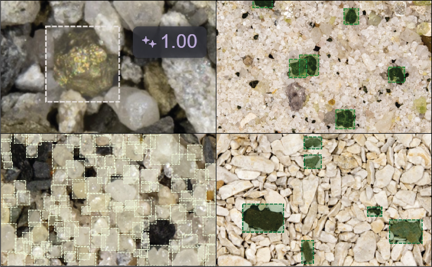
Object-detection models further identify grains, cavings, and specific minerals, allowing grain-size estimation and depositional interpretation at the sub-millimetre scale.
The lithological classification and LCM identification model have demonstrated strong performance with rapid turnaround, enabling the automated classification of 16 distinct lithologies and LCM types (Figure 2). Validation through a confusion matrix shows that the majority of samples are correctly predicted when compared to training and test data. As expected, visually similar classes — such as marl and mudstone — display a higher degree of overlap, reflecting natural variability in sample appearance rather than model error. These results confirm that the workflow provides both accuracy and efficiency for large-scale geological interpretation.
Object detection
Object detection models for cutting images locate discrete entities (Figure 6) (cuttings, grains, minerals, cavings) within images. Although larger features are successfully detected, smaller particles (<0.5 mm) and multiclass imbalances remain areas for improvement.
XRF / chemical classification
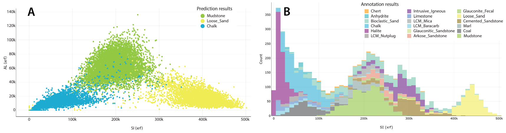
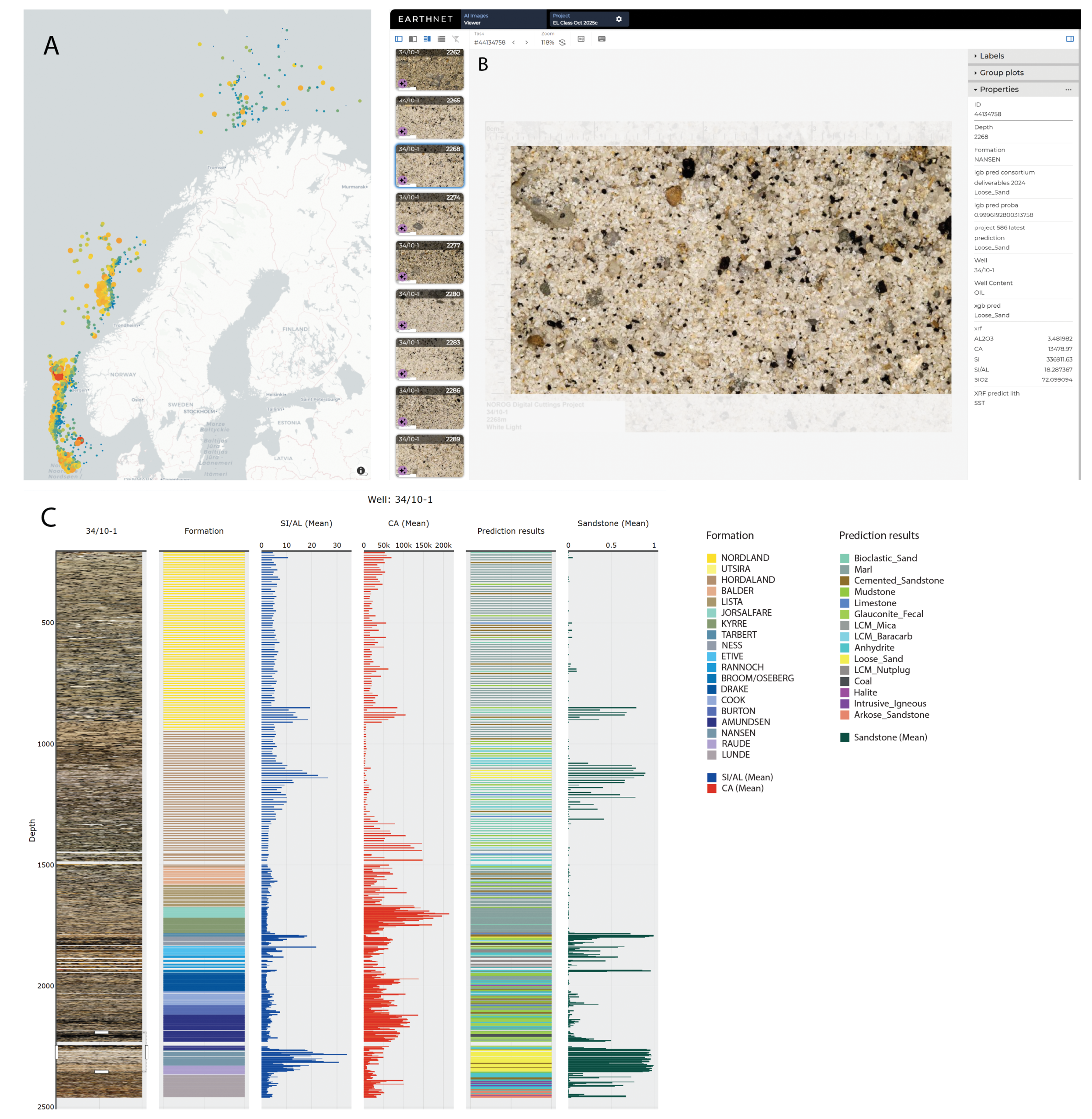
Parallel ML models classify samples based on chemical composition (XRF), providing a complementary view to imagery. These models excel at chemically distinct lithologies (e.g., halite, loose sand) and are less influenced by sample quality or surface texture. See Figure 5 for examples of lithology distribution with respect to XRF data.
As with the image classification, mixed samples may negatively affect the prediction results, i.e. a mixed limestone/mudstone sample may be predicted as a marl.
Sample types with similar chemistries may affect prediction quality, i.e. limestone/LCM Baracarb, coal/LCM Nutplug, loose sand/chert
Unlike image classification, sample quality appears to be less significant for prediction quality.
Multiple models have been tested, including LGboost, XGboost and random forest, with LGboost and XGboost showing the best results.
The product behind the research
Data are delivered through EarthNET and as a ZIP package containing LAS and CSV files. Delivery via EarthNET enables seamless ingestion into the OSDU™ Data Platform, while also providing access to ESA’s suite of visualisation and insight tools.
With EarthNET, users can visualise, query, filter and review the interpreted dataset to reveal patterns and correlations relevant to their projects (Figure 7). For clients seeking deeper analytical capabilities and integration with well logs and seismic data, a separate subscription to the full EarthNET platform includes advanced AI applications for automated data interpretation.
Now available for licensing through the EarthNET AI Images platform and module.
Key features
Scope: 718,663 cutting samples from the Released Wells Initiative (RWI) operated by NOROG.
Interpretations: Lithology (semantic segmentation), grain size, cementation, and LCM.
Metadata: Well ID, depth, log values, stratigraphy, and geographic coordinates.
Formats: Delivered via EarthNET Data Lake and ZIP (LAS + CSV); OSDU™ compatible.
Applications: Exploration, field development and CCS projects.
Looking ahead
From dusty boxes of rock cuttings to digital intelligence in the cloud, the collaboration between RockWash Geodata and Earth Science Analytics marks a step-change in how the subsurface is understood.
With the launch of the Analytics-Ready Cuttings Dataset through EarthNET AI Images (Figure 7), the Norwegian Continental Shelf becomes one of the world’s first basins where millions of rock fragments can be searched, visualised and analysed with AI precision.
What once required months of manual study can now be achieved in minutes – empowering explorers and developers from oil and gas to CCS to make faster, data-driven decisions. As machine learning continues to refine its geological vision, the NCS stands as proof that when AI meets geology, clarity follows.
If you’re interested in learning how your cuttings can provide deeper geological insights – from porosity to lithology – into your assets, or would like to gain access to this project, please contact us at contact@earthanalytics.no.


