The 2004 Covenant oil field discovery promised to open up a very favorable, large onshore oil province. Thirty additional wells have been drilled in the play since, but only one found producible oil. What happened?
Editor’s note: New Life for Overthrust Belt, in GEO ExPro, Vol. 3, No. 6, 2006, was Tom’s first article for the magazine. This update covers some of the lessons learned since that discovery.
Drilling operations at the newly discovered Covenant field, March 2005. Wolverine’s Kings Meadow Ranches No. 17-1 encountered 150m of Temple Cap Formation and Navajo Sandstone pay to end more than 50 years of disappointing results in the central Utah thrust belt. The well flowed 40° gravity oil from excellent reservoirs averaging 12% porosity and 100 mD of permeability. © Thomas Chidsey, UGS.
After the Covenant discovery, the April 2005 AAPG Explorer reported in an article entitled Utah Play Makes Lots of Headlines that “the Covenant field discovery in central Utah opens up one of the most promising onshore plays in the United States in recent memory.” Doug Strickland, exploration manager for Michigan-based Wolverine Gas and Oil Corporation at the time, had spent over 25 years studying the central Utah thrust belt (also referred to as Utah’s ‘Hingeline’) and was instrumental in obtaining their acreage position. After the discovery, he is optimistically quoted in the same Explorer article, “I honestly expect this to be a billion-barrel province – I expect we’ll find another 10 fields out there.”
Before the Kings Meadow Ranches No. 17-1 well flowed over 700 Bbopd, the central Utah thrust belt had tested the patience of explorationists for over 50 years. Their efforts had resulted in 58 consecutive dry holes for the area, so this discovery set off a great deal of speculation in the play. Landowners received large cash offers in order to lease subsurface rights; seismic crews descended on central Utah to obtain better subsurface mapping; and geologists studied new and old data to locate additional traps to be drilled. While the discovery and the new field have performed well, producing over 27 MMbo from 34 wells for Wolverine, the play continues to disappoint, plaguing explorationists with dry holes. Thirty exploratory wells have been drilled since, finding only the small, one-well Providence field located 20 km north-east of Covenant. With each well drilled, the story is still unfolding in this complex play.
The Navajo Sandstone Reservoir
Location of the Covenant and Providence fields in central Utah. Provo is the nearest large city and Utah’s capital, Salt Lake City, lies just off the map 70 km north of Provo. © UGS.
In 1999, Wolverine obtained data and an acreage position in the area from which Chevron pulled out after drilling just one well back in 1981. This well provided some key dip meter data and, combined with 2D seismic data, helped identify a prospect that was considerably updip from the well. Wolverine used some of the latest drilling methods and mud systems to get through the Jurassic Arapien Formation, which consists of highly contorted mudstones and evaporites that make both drilling and seismic mapping of structural traps difficult. The company tagged their reservoir objective, the Early Jurassic Navajo Sandstone, 425m higher than anticipated (more on this later). The well was completed and later flowed 40° API gravity oil from the 360m-thick sandstone, with the top 150m oil-saturated.
The Navajo Sandstone is probably best known for the massive exposures (670m thick) in Zion National Park (see Navajo Sandstone – A Scenic Reservoir; GEO ExPro Vol. 4, No. 1). The eolian-derived deposits that later formed the Navajo and equivalents cover parts of five western states. Back in the Jurassic, you would have encountered a great sea of sand, (often referred to as an erg, from the Arabic ‘arq’ meaning dune field), similar to today’s Sahara Desert in Northern Africa or the Alashan area of the Gobi in northern China.
“Since the Covenant discovery, new outcrop work, regional well correlations and age-dating has refined our understanding of the reservoirs,” says Thomas Chidsey, senior scientist at the Utah Geological Survey (UGS). “Building on the initial age-dating work by Chris Tolland with Oolithica Geoscience Ltd., UK, it was determined that the upper section of the reservoir is the Middle Jurassic Temple Cap Formation, which unconformably overlies the Navajo. The reservoir consists of coastal dunes (White Throne Member) associated with tidal flat deposits (Sinawava Member). Today’s analogs for these deposits are found along the Namibia coast of southwestern Africa.”
Covenant is currently the only field in Utah that produces from the Temple Cap Formation. The White Throne Member, much like the Navajo, has excellent porosity and permeability and the field produces about equally from both reservoirs.
The Structure
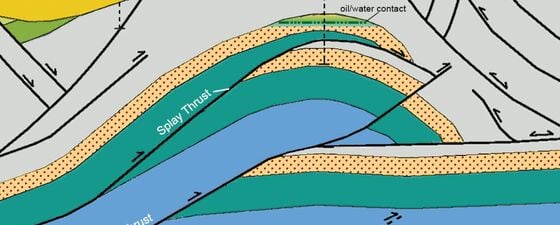
“Before drilling the discovery and subsequent wells, Wolverine geoscientists had mapped an anticline that had formed on an east-directed thrust off a larger, underlying thrust fault,” says Chidsey. “Yet, when an injection well was drilled west of the field into the Navajo Sandstone where they expected to encounter the Navajo twice based on their mapping, it was only hit once.”
North-west – southeast cross-sections through the Covenant field discovery well. (a) Old interpretation; (b) current interpretation showing the anticline that was formed by a west-directed back thrust. © UGS modified from Dr. Daniel Schelling.
Chidsey explains, “Their new interpretation fits more closely with the type of structural features found along the regional-scale Sanpete-Sevier valley anticline that has been extensively mapped by Utah Geological Survey geologists and others. Now, we were looking at the producing anticline being formed by west-directed back thrust rather than the east-directed thrust splay fault. The now-mapped back thrust likely developed after the anticline had formed. This thrust reconfigured the ‘paleotrap’ proven by Dr. David Wavrek, president of Petroleum Systems International, Inc., and others in the 2010 paper, Central Utah Thrust Belt Discoveries – A Tale of Two Hydrocarbon Charges. The lack of significant associated gas at the Covenant field is due to water washing during the remigration event.”
Structural Setting of the Sevier Belt
© Rasoul Sorkhabi.
The central Utah thrust belt is a segment of the much larger Cordilleran orogenic belt that stretches several thousand kilometers from Alaska to Central America. The Middle Jurassic to early Tertiary Cordilleran orogenic belt formed during subduction of the Farallon Plate beneath North America, with associated intrusion magma cooling slowly to form large granitic plutons like the Idaho and Sierra Nevada Batholiths. Deformation along the Cretaceous Sevier orogenic belt extends from south-west Montana, across eastern Idaho and western Wyoming, through Utah and into southern Nevada. Folding and thrust faulting occurred in this area during the Cretaceous to Paleocene Sevier Orogeny (130–60 Ma). The Sevier Orogeny was a time of active compression in response to the Farallon Plate subduction beneath the North American Plate.
Along this orogenic belt, sedimentary rock has been deformed by horizontal compression effectively shortening the rocks. Reservoir rocks can be faulted and stacked on top of each other or tightly folded to form hydrocarbon traps. This region hosts numerous fields, mostly gas, in the Canadian salient in western Alberta. The 1914 Turner Valley light oil discovery was this area’s first (see GEO ExPro Vol. 5, No. 6). In 1975, the Pineview discovery in northern Utah set off exploration in the Utah-Wyoming salient that led to the discovery of 11 additional fields including two giants (Anschutz Ranch East and Whitney Canyon-Carter Creek). The central Utah segment is located approximately 300 km south-west of the Utah-Wyoming segment where the Covenant field lies.
Complicating Factors
Finding the Covenant and Providence fields took a great deal of hard work by the geoscientists and possibly a little luck. These two finds, and a lot of dry holes, lend more complexity to the play than had been anticipated by geoscientists at the time of the Covenant discovery. Unraveling the petroleum system and accurately mapping structure are two of the complexities facing explorationists in this play.
Petroleum systems models take in all the elements that are necessary for hydrocarbons to accumulate and be preserved. In most mature producing basins, the geologic elements (source rock, migration, reservoir, trap and seal) and the timing relationships are relatively well understood.
Primary reservoirs for the Covenant field: the White Throne Member of the Temple Cap Formation is pictured along the skyline, underlain by the Navajo Sandstone. These two formations are separated by the J-1 Unconformity located at the tree line just above the Navajo Sandstone. The early Jurassic Kayenta Formation is in the foreground. © Thomas Smith.
“We are just starting to demonstrate the complexity of the petroleum system in the central Utah thrust belt,” says Dr. Wavrek. “The two discoveries give us a clue as to this complexity. The Covenant and Providence hydrocarbon charge was generated from Mississippian source rocks but at very different times. The Covenant hydrocarbons were generated early on at 90–100 Ma when the current field configuration was not established. A paleo-trap was necessary for the accumulation to form. Subsequent structural deformation that formed the current trap (70–80 Ma) resulted in hydrocarbon remigration with concurrent oil–water interaction stripping volatiles from the liquid phase. The hydrocarbon charge for the Providence field was later than the Covenant field (70–80 Ma) and was coincident with the structural development of the field. This field also contains the original gas-saturated liquid hydrocarbons that the Covenant field lacks.”
This is not the only complexity in the petroleum system that Dr. Wavrek would like to bring out. “The Arapien Formation poses two additional complicating factors in finding producible hydrocarbons,” he explains. “First, this complex and deformed mixture of clastic components, salts, and carbonates does not always provide the perfect seal. While the Arapien Formation is considered a regional seal, there are situations where it does leak that lead to dry holes. Satellite imaging shows the effects of micro-seepage through this shale by altering mineral signatures at the surface (GEO ExPro Vol. 3, No. 6). The complex mixture of greatly variable rock types pose the second complexity by distorting the time to depth conversion on seismic; hitting the reservoir much higher than predicted at the Covenant field was a clear example of this phenomenon. Since velocities through most salts are much faster than through carbonate and clastics, a salt pod (known to exist in the Arapien Formation) would be underlain by a seismic pull-up and a false anticline could be mapped.”
A hallmark of the Navajo Sandstone is the distinctive cross bedding, as exposed along the scenic drives through Zion National Park. © Thomas Smith.
“Finding good reservoir rocks could also be another complicating factor,” Chidsey points out. “Outside the excellent reservoirs in the Navajo and Temple Cap sandstones, other formations in the region often have low porosity and permeability and are unable to store or produce oil.”
The Next Steps
While geoscientists have learned a great deal about the central Utah thrust belt, successful results have been very hard to come by, in part, from the true complexity of this play. This play may never see the results seen in the thrust belt salients that lie to the north. The Covenant may just remain the ‘lucky one’ until some geoscientist finds yet another prospect that a company is willing to risk big on. “There is much still to understand in central Utah,” says Chidsey.


