In 2008 the Optowave fibre-optic seismic sensor cable was trenched at the StatoilHydro-operated Snorre field with the aim of achieving insight into installation, data acquisition and monitoring procedures. The Snorre…
Kim Gunn Maver, Colin Hulme, Mark McCallum, and Ajay Nalonnil, Schlumberger
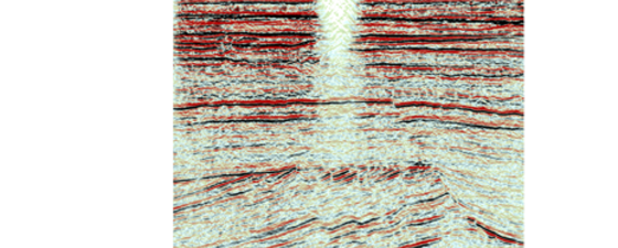
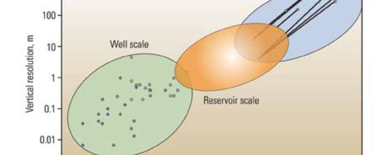
Deep-reading technologies image the interwell space at higher resolution and provide a new scale of characterization that was previously not possible. In recent years, more oil and gas reserves have…
“Coil shooting” is a cost-effective technique towards better imaging over small to medium sized exploration areas. Encouraging results may lead to a rapid increase in the next 5+ years. Seismic…
In 1828, Johann Gauss developed his theorema egregium, latin for remarkable, to deal with curvature in 3-dimensional space. Now, through the use of volumetric curvature attributes, geoscientists apply this remarkable…
The need to maximise recovery has spelt success for a seismic technique which hugely increases reservoir knowledge. Z-Seis is a specialist seismic company concentrating exclusively on the acquisition and processing…
Passive low-frequency seismic is an area of active research and development, and is rapidly being taken up as a new direct hydrocarbon indicator (DHI) technique for exploration. The interest in…
Roy H. Gabrielsen, University of Oslo, Norway, Xavier Fort, Geosciences Rennes, Université Rennes, France, and Ole Martinsen, StatoilHydro Research Center, Norway
Salt structures come in every possible shape and stretch our imagination. This means difficulties in seismic imaging, but it also means that the innovative explorationist can look for spectacular traps.…
New approach makes geophysical results available to engineers in a form they can use. History matching, volumetric calculations and reserve estimates may all be improved. Most oil and gas exploration…
Rifting caused the breakup of Western Gondwana into two separate continents and is responsible for the key elements of a mega petroleum system that is now being fully exploited. There…
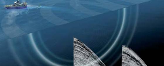
Seismic imaging is considered key to reducing risk and cost in exploratory as well as development drilling. Seismic acquisition geometry impacts the seismic image, so in this article we show…
Polarcus is a new seismic company with an unusual agenda – to pioneer the acquisition of high quality towed streamer seismic data while causing minimal impact on the environment. “Our…
Sarah G. Stanley, Director of Training Seismic Micro-Technology
Conventional amplitude seismic interpretation may not delineate thin sands. However, through the use of horizon attributes, various seismic attributes, and the spectral decomposition of the seismic volume, it is possible…