Jim Morse and Dimitri Massaras, Computational Geology Inc.
Complete dip and image analysis improves structural interpretations and reduces risk. Is your seismic fair or poor? Are your structures complex? Are your reservoirs sub-thrust, sub-basalt, sub-salt, or pre-salt? Are…
Tron Kristiansen, Olav Barkved, Martin Landrø and Lasse Amundsen
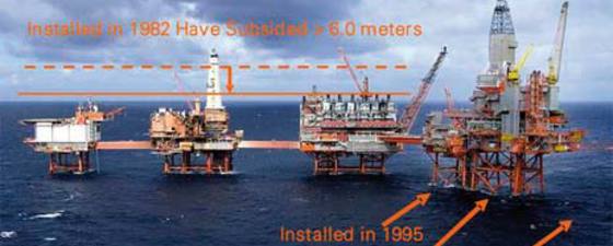
This article discusses the linkage between 4D seismic responses and geomechanics. Exploitation of this relationship has helped reduce development costs and maximize recovery from the compacting Valhall reservoir. The 4D…
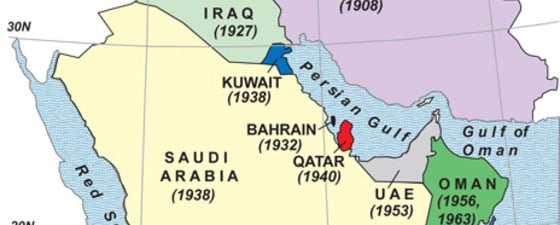
Flashbacks on the first discoveries of oil fields in the Middle East. 1908 (May 26): Masjid Sulaiman field (Masjid Sulaiman-1 well), southwest Zagros basin, Iran (Persia) by the Concessions Syndicate…
Permanent seismic monitoring is an emerging market with significant potential. Who are the major players and what has been done to validate the Optowave technology? This article has been designed…
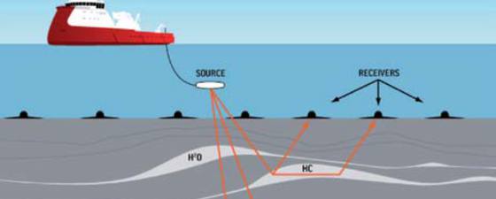
Fibre optic sensing technology offers the potential for a cost-effective, reliable reservoir monitoring system as an alternative to seismic systems based on electronics. Interested in learning about fibre optic seismic…
Fred Aminzadeh, Past President, Society of Exploration Geophysicists and Larry L
The use of geophysical methods in petroleum exploration continues to expand and is an integral discipline in the discovery and production of oil and gas deposits. We have seen a…
The main purpose of applying EM data is to improve exploration decision making. “As a geoscientist working in an oil company which values integration, we try to maximise the use…
Professor Erik Flekkoey, University of Oslo and Petromarker a/s
Electromagnetic surveying is one of the least well understood of the non-seismic exploration techniques. There are various acquisition choices to be made – for example it can be undertaken using…
Jane Whaley, GEO ExPro, and Stephen Tyson, Paradigm
Modelling reservoirs using a 3D grid is a common tool for both the geologist and the reservoir engineer. As models increase in structural and stratigraphic complexity the process of creating…
Making depth conversions more reliable has become an obsession for a dedicated geophysicist. As a result the Norwegian consultancy Aker Geo now claims to have the very best tool to…
The Valhall permanent seismic array (Life of Field Seismic; LoFS) has successfully provided easy access to high quality 4D images for the purpose of improving oil recovery. This article provides…
Large-scale volcanism caused by a superplume in the mantle was possibly responsible for wide-spread deposition of excellent source rocks in Mid-Cretaceous times. Organic rich source rocks buried deep in sedimentary…