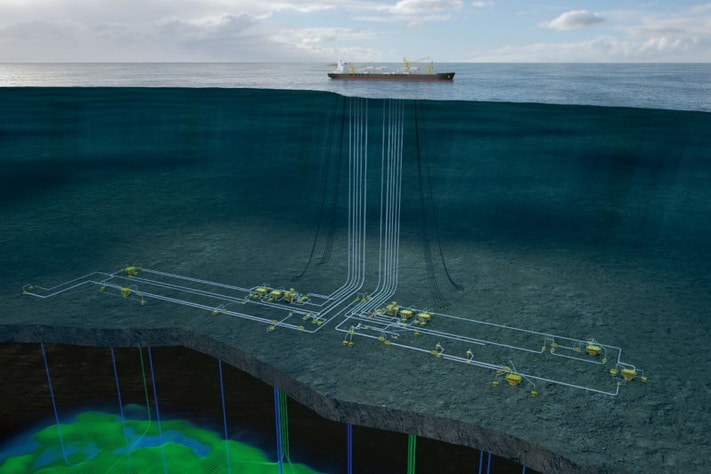
Ghana’s ascendancy as a significant oil and gas producer commenced with the landmark Jubilee discovery in 2007, leading to first oil in 2010. This success was subsequently reinforced by the discovery of Tweneboa, Enyenra, and Ntomme (TEN) fields.
While historical exploration efforts have predominantly concentrated on the Tano Basin in both Ghana and Côte d’Ivoire – highlighted by recent success at Baleine in the Deep Tano Basin – a compelling new focus is now shifting eastward to the offshore Keta Basin. This basin presents a geological setting ripe for renewed hydrocarbon exploration.
Despite its inherent potential, the Keta Basin has, to date, remained somewhat overshadowed. Previous deepwater exploration efforts by ENI, Afren, and Devon Energy have yielded only one sub-commercial gas discovery at Tarpon-1. However, a comprehensive re-evaluation of the Keta Basin’s sediment provenance history, integrated with past well results, strongly suggests that the basin shares more geological commonalities with the productive Tano Basin than previously presumed, thereby indicating the potential for analogous hydrocarbon resources.
For International Oil Companies (IOCs), the Keta Basin should represent a very attractive frontier, characterised by its extensive running-room, strategic proximity to existing oil discoveries, and considerable scale, aligning perfectly with modern exploration priorities; all set in an existing oil-producing nation.
Here, we delineate three pivotal reasons underscoring the Keta Basin’s compelling similarities to the Tano Basin, positioning it as a high-potential, yet underexplored, frontier.
1. Provenance and transport path: Keta’s cretaceous sands have the same provenance and transport path as Tano’s
A common challenge in many discoveries across the Transform Margin has been the sub-commercial nature of reservoirs. While most wells have encountered hydrocarbon presence, reservoir quality is often compromised due to the mineralogical immaturity of the sands.
The Tano Basin stands as a notable exception to this trend, boasting sandstone reservoirs with excellent permeabilities that support viable flow rates, enabling fields to progress to development. Sourced from the Sourou Basin and traversing the Palaeozoic Volta Basin, these systems are much more mature in terms of mineralogical content than many other reservoirs found along the broader Transform Margin.
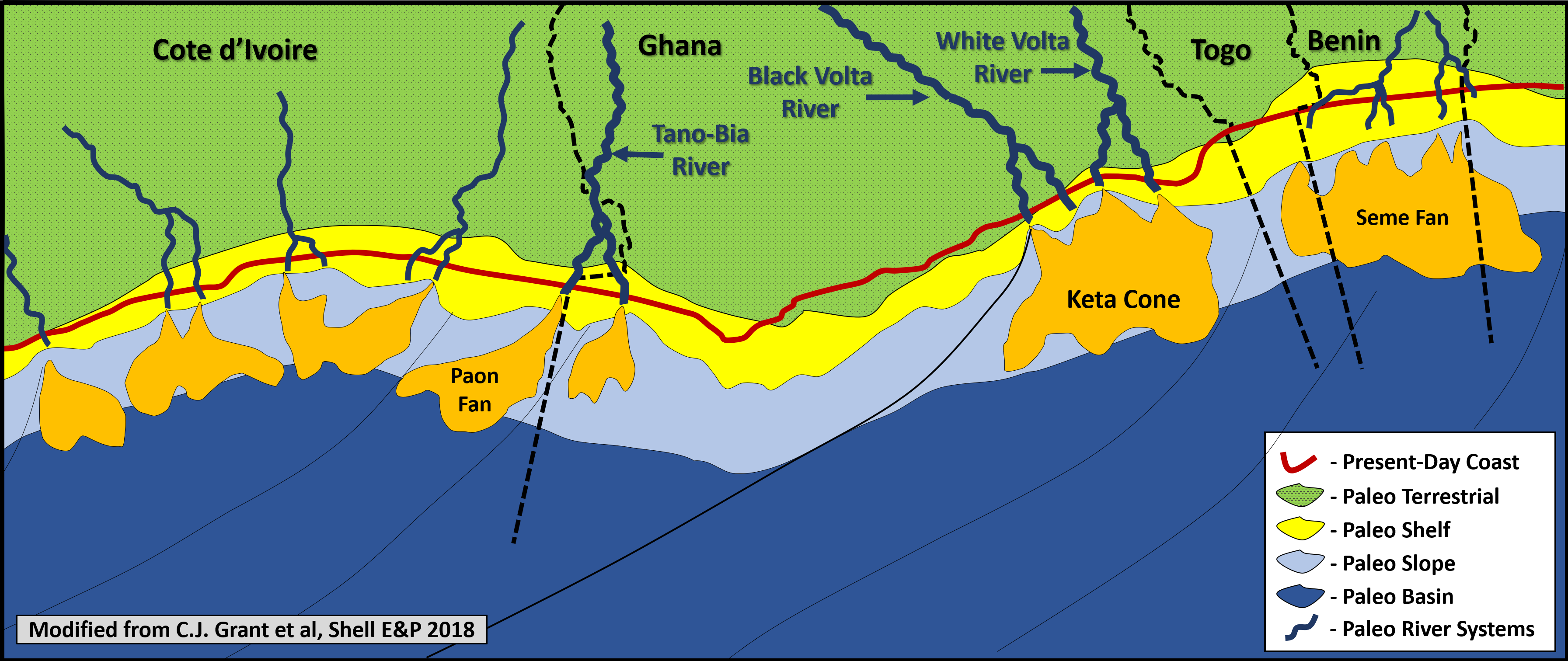
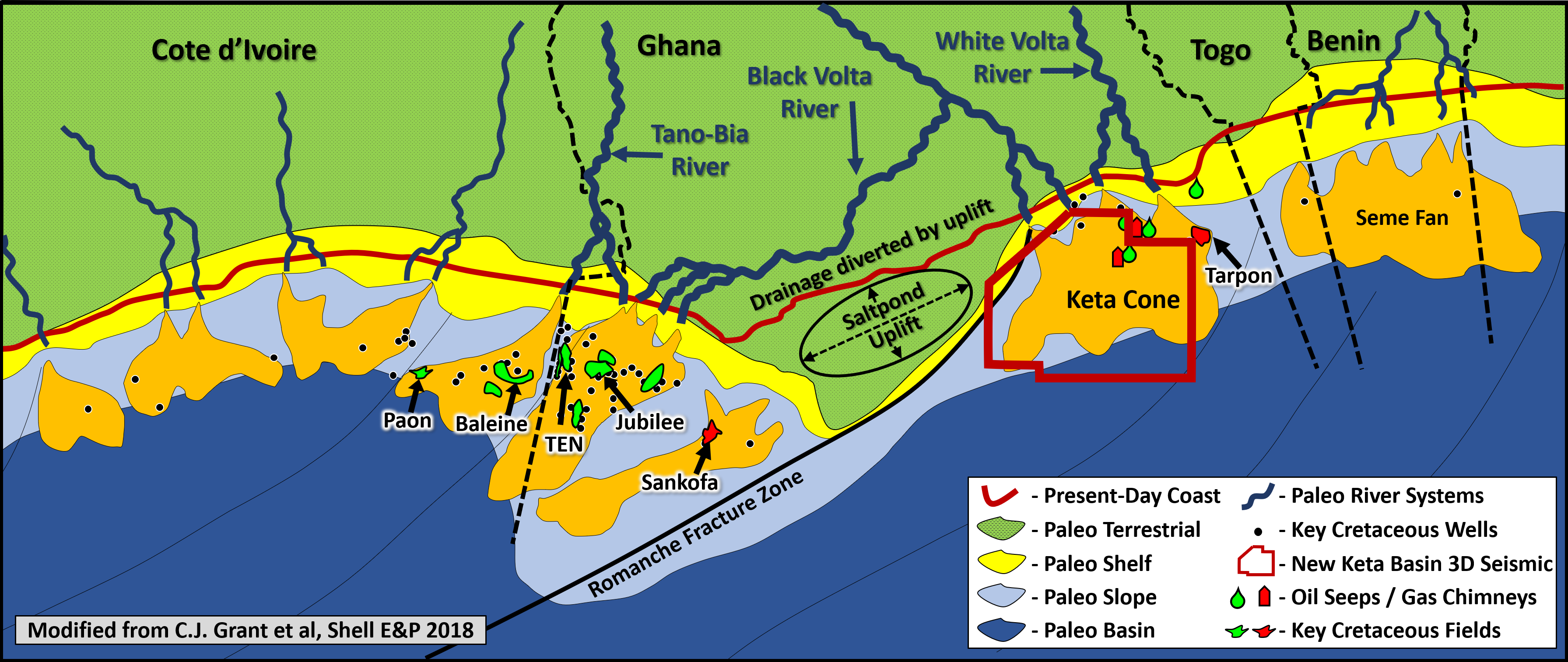
Crucially, prior to the inversion of the Saltpond High in Early to Mid-Cretaceous times, both the Black and White Volta fluvial systems were actively feeding the offshore Keta Basin (Figure 2a). The subsequent uplift of the Saltpond High during the Campanian redirected the Black Volta fluvial systems westward into the Tano Basin, depositing the prolific Mahogany and West Cape Three Points fan bodies. These fans are now host to numerous significant discoveries, including the Jubilee, TEN, and Sankofa Fields (Figure 2b; Grant et al, 2018). Consequently, the Keta Basin is endowed with the same mineralogically mature Cretaceous sandstones as the Tano Basin, a critical factor for reservoir quality.
2. Multiple source rocks and post-trap formation expulsion: A Tano analogue
Modelling of source rock expulsion, utilising available well data from the Keta Basin, demonstrates a favourable timing of trap formation. The syn-rift source rock is modelled to expel hydrocarbons towards the end of the Cretaceous, while the Cenomanian-Turonian source rock expels in the mid-Eocene in deep water settings and the mid-Miocene in shallower waters.
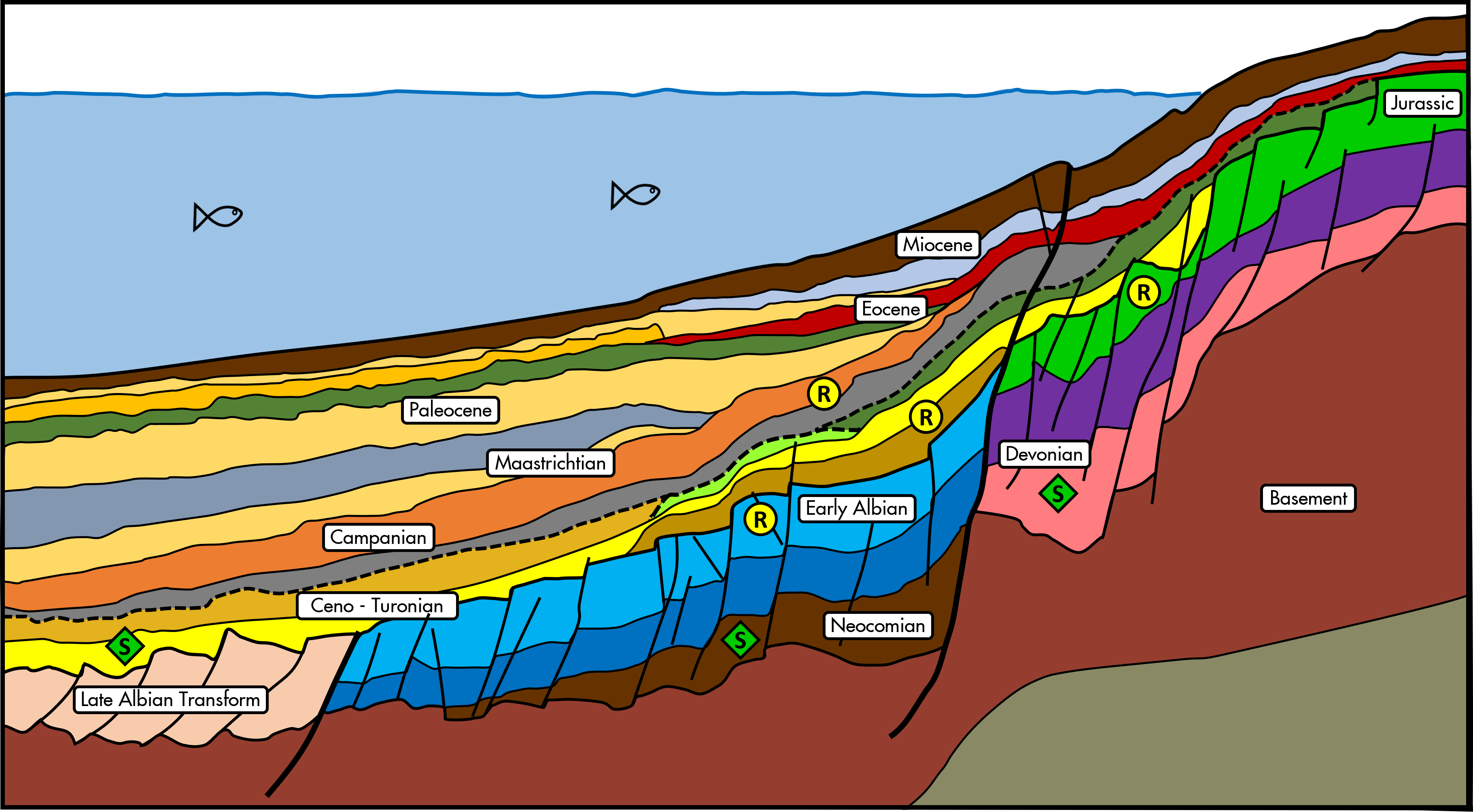
Throughout the West African Transform Margin, a significant exploration risk is posed by late-stage tectonism, leading to trap breach. In Côte d’Ivoire, this is a primary cause of deepwater well failures. The success observed in Tano correlates strongly with a period of tectonic quiescence after trap formation. Similar observations are evident in Keta, where inversion ceased in the Campanian, ensuring that transform-related traps remained intact post-charge. Figure 1 shows a Geoseismic section, with source and reservoir units marked.
3. Exploration history: Keta’s underexplored potential parallels early Yano
The Keta Basin’s deepwater exploration history is remarkably limited, with only three 3D seismic surveys and six wells drilled to date. Dolphin-1, spudded in 2000, followed by NAK-IX and Keta-1 in 2001 (both drilled on 3D data), all yielded oil fluid inclusions within Albian-Cenomanian shelf-slope deposits. The only deepwater wells in the basin were Tarpon-1 (Devon Energy, 2003), Cuda-1 (Afren, 2008), and Nunya-1 (ENI, 2012), drilled on two 3D surveys. While Cuda-1 and Nunya-1 exhibited oil shows, Tarpon-1 encountered a gas-bearing sandstone in the Mid-Miocene. The most recent well, Starfish-1 (Ophir), was dry but notably encountered 230 m of good quality, Tano-style sands in the Lower Cretaceous.
When compared to the Tano Basin’s exploration history prior to the 2007 Jubilee discovery, the results in Keta are strikingly comparable. The first speculative 3D seismic surveys in deepwater Tano were acquired from 2000 onwards, prompting Tullow to license the deepwater acreage in 2004. By 2007, the Jubilee Field had been discovered in just the second phase of drilling. Similar successes could readily be replicated in the Keta Basin, which has yet to experience a second, more comprehensive drilling phase.
Future exploration outlook and government support
The combination of these below-ground geological factors positions the offshore Keta Basin as an area with significant future exploration potential in Ghana. While seal integrity has historically been considered a primary exploration risk in the Keta Basin, new high-resolution 3D seismic data and integration with newly defined geological models will actively de-risk this concern. The interpreted development of effective seal lithologies and the favourable timing of trap formation, particularly the pre-charge Campanian onlap traps, significantly enhance confidence in seal effectiveness across prospective intervals.
In recognition of this potential, GeoPartners is planning to acquire a 14,000 km2 3D seismic survey in Q4 2025 (Figure 2). This data acquisition is anticipated to be instrumental in de-risking identified prospects, providing advanced subsurface imaging, and attracting further investment required to fully assess the hydrocarbon potential of the Keta Basin.
Additionally, the current government, facilitated by the Petroleum Commission as regulator, has expressed a clear and positive commitment to enhancing Ghana’s oil and gas sector. Initiatives are underway to streamline exploration processes and foster an attractive investment climate, aiming to position Ghana as a key destination for energy investment over the forthcoming years.