A cross section of Norway: putting the pieces together
By assembling and merging a fragmented dataset of 3D seismic, it is possible to release the hydrocarbon potential of the Norwegian Continental Shelf.
Since the start of hydrocarbon exploration in Norway in the 1960s a phenomenal amount of 2D and 3D seismic data has been acquired on the Norwegian Continental Shelf. This data was acquired piecemeal, focused on small areas with specific targets. Fortunately the data has been well managed by the Norwegian government and released into the public domain on a regular basis. By assembling this fragmented dataset we facilitate a unique geological tool for imaging and analysis of the Norwegian Continental Shelf.
The ‘seismic shift’ in this concept has occurred recently from the merging of released 3D datasets into vast carpets of data that realise the potential for efficient new assessment of the Norwegian Continental Shelf at both regional and field or prospect specific level. Oil companies are therefore able to view their assets in a regional 3D seismic perspective, re-assessing released wells as well as performing petroleum system modelling, potential field modelling and seismic attribute analysis.
More than a Jigsaw puzzle
However, merging numerous 3D seismic surveys together to create a uniform dataset is far from a straightforward exercise. Each piece of the jigsaw puzzle overlaps the adjacent pieces, has different acquisition orientations and varying processing sequences and therefore varies in quality (bandwidth and signal to noise ratio).
Spectrum’s Seamless Seismic product has been constructed taking all these factors into account, creating a merged dataset where the joins between surveys are, rather as you would expect, seamless. Additionally the dataset is dynamic as we are continuously integrating the stream of new 3D surveys being released.
The source data quality does vary from survey to survey, and to prevent mis-stacking when the final merge is applied, some processing is required prior to merging.
Our guiding philosophy is to try and keep as much as possible of the original character of the data, whilst maintaining the overall quality of the final seamlessly merged volume. The standard processing scheme includes:
- Seismic and navigation data validation
- Survey regridding
- Survey matching
- Survey merging
Basin to burner tip interpretation
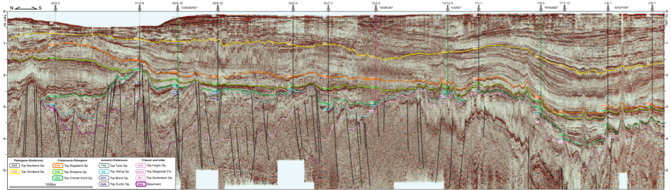
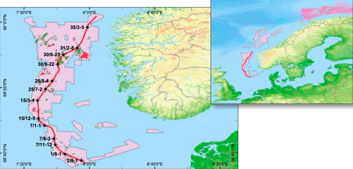
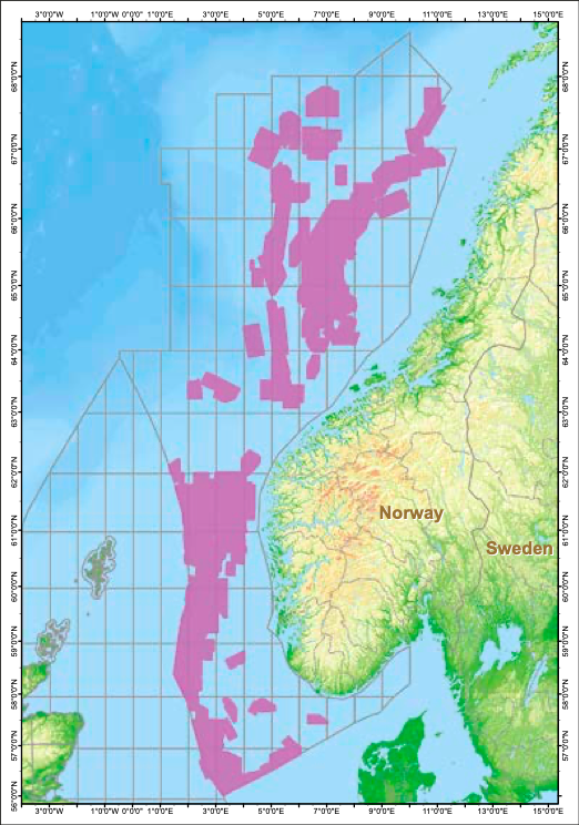
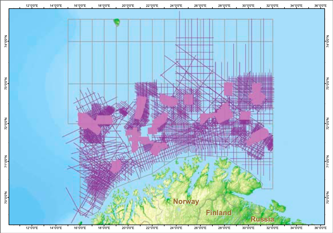
The Seamless Seismic product has to-date accumulated over 125,000 km2 of 3D data from the Norwegian Shelf. This dataset extends from the Norwegian Southern North Sea Basin through to the Eastern Barents Sea. The foldout on the previous page is an example of a broadly south-north strike line through the Southern and Northern Basins.
At a regional scale this extraordinary line, over 810 km long, illustrates the difference between the Southern and Northern Basins. In the south, early Permian rifting develops the thick Permian salt sequence which dominates the Mesozoic potential. Extension and deposition in the Jurassic and Triassic developed diapirs and salt walls yield intricately short wavelength sediment pod and intrapod plays, in addition to later Cretaceous dome and down-building plays. By comparison, in the north the Mesozoic plays are dominated by simple extension and Jurassic and Cretaceous fault blocks on a grand scale. Over both basins the Tertiary thermal sag deposited thick clastic sequences, except in the far north where significant late basin inversion has significantly thinned the Tertiary sequence.
Whilst such observations are apparent on 2D data, the elegance of being able to correlate over multiple basins seamlessly allows locally developed geo-phenomena to be put into a regional context, and insights used to drive exploration concepts. And it is here that the multiple working scales of this seamless dataset open the opportunity not only to re-evaluate held and open acreage, but also to burrow down to take another look at old wells and abandoned fields, with the context of basin scale petroleum system analysis.
Contextualising the hard-won insights of the oil industry at all scales will generate new, untested concepts and open new exploration creaming curves in this exciting margin.
Tie with released well data
The Norwegian authorities have also released well data into the public domain, and so the next step for this dataset is to tie log data into the seismic dataset. The 3D seismic merged database already incorporates all released 3D surveys, and work is ongoing to incorporate the well data. This will generate a cost-effect tool to give access not only to the imagination-food of seamlessly carpeted 3D seismic but also the ground-truthing power of drill bit experience.
The future
During the next six years a minimum of 200 3D surveys are due to be released over the Norwegian Continental Shelf. These will be combined continuously into the existing dataset, in addition to all released well data, creating a dynamic and ever evolving insight-engine to release the barely touched hydrocarbon potential of the Norwegian Continental Shelf.


