The offshore basins to the west of Madagascar are part of a large Gondwana break-up rift basin that formed during the early Mesozoic. The strike-slip rifting propagated southwards and includes several basins offshore Tanzania, Kenya and Mozambique. These basins make up a large prospective area that already has some significant discoveries, notably Sunbird offshore Kenya (oil) and Windjammer and Ironclad offshore Mozambique (gas). Due to the recent drilling successes, this trend has regained industry interest.

Madagascar – satellite image, location map and terrain map.
The deepwater Offshore Morondava Basin and Kerimbas Graben (also known as Lacerda Graben), which is the focus of this article, is undrilled and has licence blocks that are mostly open, with a planned competitive licensing round anticipated in 2015.
The TGS regional offshore geophysical data coverage in the region amounts to some 51,000 km of modern multiclient offshore 2D data. In addition the company have compiled logs and reports for 98 exploration wells in the adjacent shallow offshore and Onshore Morondava Basin.
Rifting Governs Geology
Onshore Madagascar, Tanzania and Kenya host failed Permo-Triassic rift basins. Permo-Triassic hydrocarbon deposits in the Onshore Morondava Basin have been known since 1842 and contain the Bemolanga and Tsimiroro oil fields.
The Offshore Morondava Basin and Kerimbas Graben to the west of Madagascar formed in the Jurassic as a result of the separation of the Madagascar-Indian plate from the African plate. This break-up is likely to have followed or reactivated earlier Palaeozoic rift basins, with some evidence for these being interpreted within the Davie Ridge. Madagascar drifted south-eastwards away from the African plate throughout the Early Cretaceous along the Davie Fracture Zone, resulting in the transtensional and transpressive reactivation of existing fault systems. This rifting and transform movement resulted in the two major offshore basins: the Offshore Morondava Basin and the Kerimbas Graben, which are divided by the north-north-west to south-south-east oriented Davie Ridge.
In addition to the fault reactivation and deformation due to the right-lateral transform movement along the Davie Fracture Zone, the separation of the Indian plate from the Madagascan plate in Late Cretaceous times led to accelerated subsidence as well as compression and local inversion of the Jurassic rift basin. This break-up of the Madagascan and Indian plate was associated with igneous intrusion and volcanism. The volcanics form a regional stratigraphic marker of Cenomanian to Santonian age (Maloney et al, 2008).
Interesting Structural Features
The Offshore Morondava Basin: The Permian shale source rock for the onshore Bemolanga Tar Sands may be present in the Offshore Morondava Basin, although it must be noted that there is as yet no direct evidence from drilling.
The original normal faults of the Offshore Morondava Basin and other rift basins to the north along trend have been re-activated by dextral strikeslip faulting. Major faults should have large throws with thick sediment piles developed in transtensional basins. The syn-rift sediments of this basin are Jurassic to possible Early Cretaceous in age (Rusk & Bertagne, 2003) and are likely to contain lacustrine or restricted marine source rocks together with alluvial and fluvial sheetflood sandstones, which can have excellent reservoir properties. The syn-rift sediments are interpreted to be present throughout the Offshore Morondava Basin.
A thick post-rift Cretaceous and Tertiary section overlies the syn-rift sediments and is interpreted to host reservoir and seal sequences comprising sand-rich turbidites, submarine channel and mass-flow deposits. A Late Cretaceous regional volcanic event can provide a good seal over much of the area.
For a discussion on the The Davie Ridge and The Kerimbas Graben click on the hotspot map below.


Satellite gravity map of the offshore Madagascar regions showing the major structural elements and the location of the MAD13 survey. Note the Davie Ridge that accommodates the right lateral strike-slip faulting (Satellite gravity backdrop from Scripps Institute of Oceanography, University of California).
The Source Rock Model
Early to Late Jurassic and Early Cretaceous oil-prone shales have been identified in the coastal wells and are likely to have been deposited within open marine, lacustrine, restricted shallow marine and lagoonal environments. They are also expected to be present westward and basinward into the Offshore Morondava Basin (Rusk, Bertagne and Associates, 2003; USGS, 2012) and may also be present in the Kerimbas Graben since source rocks of the same age are found in the basins of coastal Mozambique, the Mozambique Channel and Tanzania (USGS, 2012).
Initial Offshore Morondava Basin thermal modelling studies of Jurassic source rocks were undertaken at selected pseudo-well sites. Limited thermal and maturation data were available from the shelfal wells to assist in constraining the modelling. Beta factors of 2.0 and 2.4 were used for the Jurassic rifting and the Late Cretaceous stretching due to the break-up of India and Madagascar. Shallower depths of burial eastwards will lead to later oil expulsion events and the potential for older source rocks to contribute to the petroleum system.

Expulsion timing for source rocks at depths A (Type I: lacustrine) and B (Type III: coaly) (Source: TGS/BGP)
The modelling indicates that the coaly source rocks expelled oil from Early to Late Cretaceous after which they passed into the gas window. The younger Late Jurassic lacustrine source rocks started expelling oil in the early Tertiary and this oil expulsion continued until the Pliocene. Early Cretaceous source rocks are likely to be in the oil expulsion window present day within the Offshore Morondava Basin.
Numerous fluid conduits can be seen on the seismic sections emanating from the syn-rift sediments in both the Kerimbas Graben and Offshore Morondava Basin. These features may indicate possible vertical hydrocarbon migration pathways.
Highlights
Offshore Madagascar has the potential for widespread Jurassic to Early Cretaceous source rocks to be present, which are modelled as mature for oil within the study area. This indicates the presence of a new oil play in East Africa, where the received wisdom is that the area is likely to be another gas-prone province. Within the stacked reservoir sequences of the syn-rift and post-rift, there exists a variety of structural and combination trapping mechanisms which appear favourable for charge when the timing of late oil expulsion is modelled.
With a licence round to be announced in 2015, and the area covered by the MAD13 survey containing over 40 blocks of open acreage, this is an attractive undrilled frontier on which to focus.
Play Type Examples

Play Type A: Mid Cretaceous post-rift play with flat spot – Kerimbas Graben Play Type A is a post-rift sand-prone slope fan that displays a prominent flat spot. This is found just above the location of expected mature rocks in the Late Jurassic. The faulted syn-rift section below this also shows trapping potential.

Play Type B: Cretaceous early post-rift play in sand-prone slope fan sandstones – Kerimbas Graben Play Type B shows a post-rift slope fan with structural trap potential (upper section) and combination stratigraphic pinch-out with possible updip fault seal (lower section). This play is just above the location of expected mature source rocks.

Play Type C: Sand-prone slope fan pinch-out – eastern flank Offshore Morondava Basin Play Type C shows three sand-prone slope fans separated by deep water mud-prone facies. The sand fans display a hummocky facies character with generally good seismic continuity. The interbedded mudstones can act as intraformational seals.
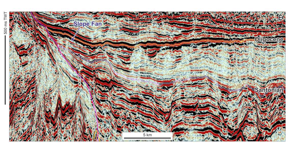
Play Type D: Offshore Morondava Basin sand-prone slope fan pinch-out against the Davie Ridge Play Type D shows a Paleogene slope fan overlying a Cretaceous slope fan. The Paleogene fan pinches out against the Davie Ridge and shows brightening updip, which is a possible indication of hydrocarbon charge.


