
Finding new or under-explored sedimentary basins is a key aim for many frontier exploration groups, and using gravity and magnetic data is a very cost-effective method of identifying and mapping their extents.
Sediment thickness estimates are important for the New Ventures explorationist to identify potentially productive sedimentary basins and to map their extent. These maps provide a vital constraint for source rock maturity modelling and for understanding the local thermal regime in both conventional and unconventional exploration settings.
Getech has developed an integrated approach to map sedimentary thickness on a global scale using the best global compilations of gravity and magnetic data. The approach uses the relative merits of each of the data sets and recent advanced methodology in depth-to-source estimation.
Potential Fields
Gravity and magnetic data have long been tools for mapping depth-to-basement given that density and/or susceptibility contrasts at the basement-sediment boundary should yield an anomaly that can be interpreted in terms of depth. These data generally offer a relatively quick and cost-effective evaluation of large areas. On a global scale, the availability and resolution of data are inevitably variable, and therefore this workflow has focused on an integrated approach that uses the relative merits of each of the data sets together with recent advances in depth-to-source interpretation methodologies.
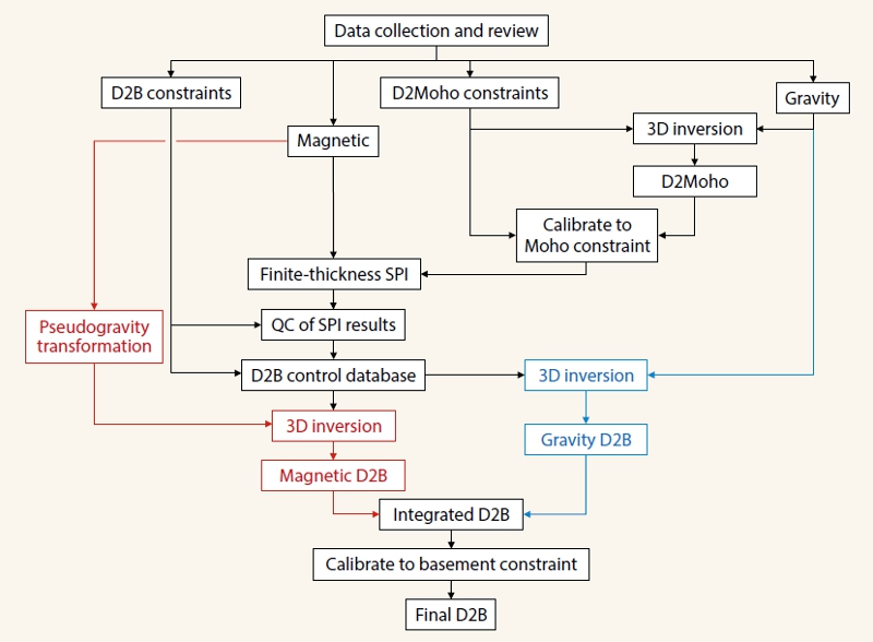 Figure 1: Depth-to-basement workflow showing the integration of the magnetic methods (in red to the left) and the gravity methods (in blue to the right) to produce a final composite depth-to-basement map. (Source: Getech)In the absence of large volcanic provinces, magnetic data is generally a more robust tool for depth-to-basement estimation. This is due to the fact that the basement rocks usually have a distinctive magnetic susceptibility contrast with respect to overlying sedimentary rocks. In general, sediments have a very low susceptibility, and for interpretation purposes can often be considered to be non-magnetic. Basement rocks have a much higher susceptibility; therefore, recordings of the magnetic field at the surface can generally be considered to be derived from the basement.
Where a density contrast at the basement exists, gravity data may also be used to invert for basement depths. However, density variations within the sediments can produce a significant contribution to the observed gravity data, which adds complexity. A significant density contrast is also likely to exist at the Moho, and hence play an important contributory part of the gravity anomaly. A good estimate of the depth-to-Moho is therefore an important part of Getech’s workflow, Figure 1 (opposite).
Global Data Compilations
The fundamental data sets used are global compilations of gravity and magnetic data. These have been generated by merging thousands of individual land, marine, airborne and satellite surveys in a consistent manner into global 2 km (gravity) and 1 km (magnetic) grids.
Data coverage of the two data types is highly variable, and choosing which to use in different areas depends on coverage, geological terrain and data resolution. For example, in the offshore continental margins there are a number of good magnetic surveys, but these are generally in small localised areas. Conversely, the gravity data in the offshore margin areas are of a very consistent quality and coverage owing to the availability of the latest satellite altimeter derived data. A workflow to incorporate both the patchy magnetic data (which allows a more direct estimation of basement depth) and the gravity data (which offers good coverage, but may depict basement more indirectly) is therefore the first challenge.
Integrating Additional Resources
The workflow Getech has developed is demonstrated by a walk-through of an example area from north-eastern USA in Figure 2 (below) and is shown in chart form in Figure 1 (above).
A key aspect of the workflow involves the building and validation of a database of individual depth-to-basement measurements, which is used as a control on the final interpretation. These points derive from published depth-to-basement values from literature (e.g. from seismic data), well data, outcrop information and depth-to-magnetic source estimates calculated directly from magnetic data where there is a high confidence. This depth-to-basement database is then used to identify largescale regional variations across the area so that these can be incorporated into a final 3D inversion from either the magnetic or the gravity data. The global scope of the work means that the magnetic and gravity coverage will vary from area to area, and the final map will comprise elements from both the magnetic and gravity interpretations.
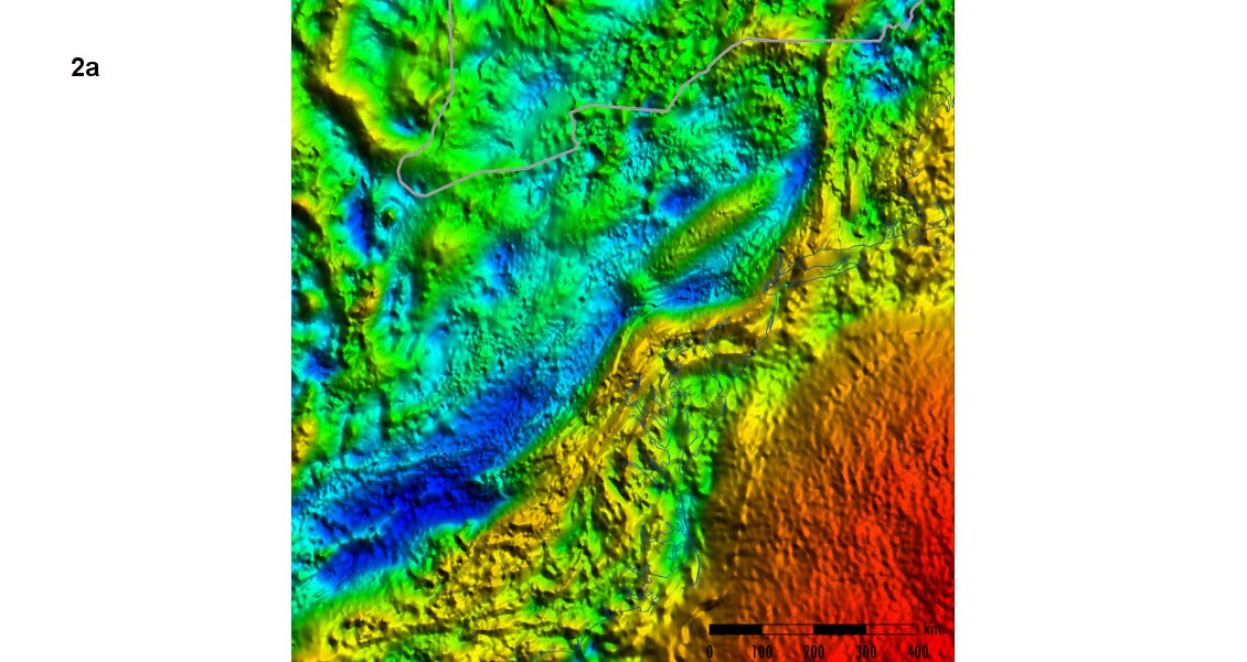
Figure 2: Example from north-eastern USA illustrating the integrated workflow. The Bouguer gravity anomaly (a) is compared against predicted gravity response from the Moho constraint (b) and is low-pass filtered until the maximum cross correlation is achieved (c). This is then inverted for depth-to- Moho (d), which is incorporated as a finite depth constraint when the magnetic data (e) is used for derivation of discrete magnetic depth estimates (f). The high confidence magnetic estimates are used in conjunction with independent constraints (g), before 3D inversions of magnetic (pseudogravity) and gravity data to produce the final integrated depth-to-basement map (h).
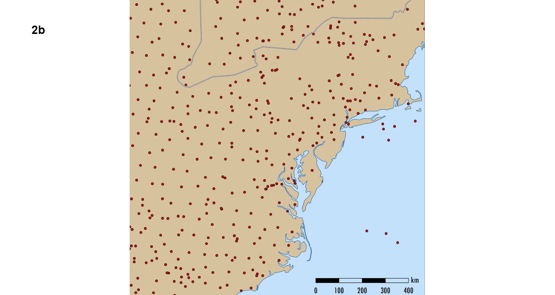
Figure 2: Example from north-eastern USA illustrating the integrated workflow. The Bouguer gravity anomaly (a) is compared against predicted gravity response from the Moho constraint (b) and is low-pass filtered until the maximum cross correlation is achieved (c). This is then inverted for depth-to- Moho (d), which is incorporated as a finite depth constraint when the magnetic data (e) is used for derivation of discrete magnetic depth estimates (f). The high confidence magnetic estimates are used in conjunction with independent constraints (g), before 3D inversions of magnetic (pseudogravity) and gravity data to produce the final integrated depth-to-basement map (h).
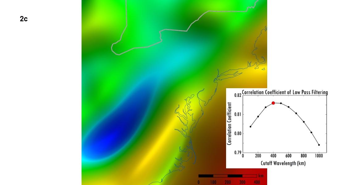
Figure 2: Example from north-eastern USA illustrating the integrated workflow. The Bouguer gravity anomaly (a) is compared against predicted gravity response from the Moho constraint (b) and is low-pass filtered until the maximum cross correlation is achieved (c). This is then inverted for depth-to- Moho (d), which is incorporated as a finite depth constraint when the magnetic data (e) is used for derivation of discrete magnetic depth estimates (f). The high confidence magnetic estimates are used in conjunction with independent constraints (g), before 3D inversions of magnetic (pseudogravity) and gravity data to produce the final integrated depth-to-basement map (h).
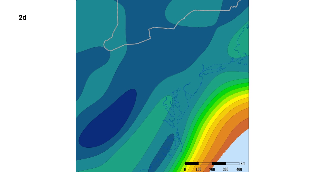
Figure 2: Example from north-eastern USA illustrating the integrated workflow. The Bouguer gravity anomaly (a) is compared against predicted gravity response from the Moho constraint (b) and is low-pass filtered until the maximum cross correlation is achieved (c). This is then inverted for depth-to- Moho (d), which is incorporated as a finite depth constraint when the magnetic data (e) is used for derivation of discrete magnetic depth estimates (f). The high confidence magnetic estimates are used in conjunction with independent constraints (g), before 3D inversions of magnetic (pseudogravity) and gravity data to produce the final integrated depth-to-basement map (h).
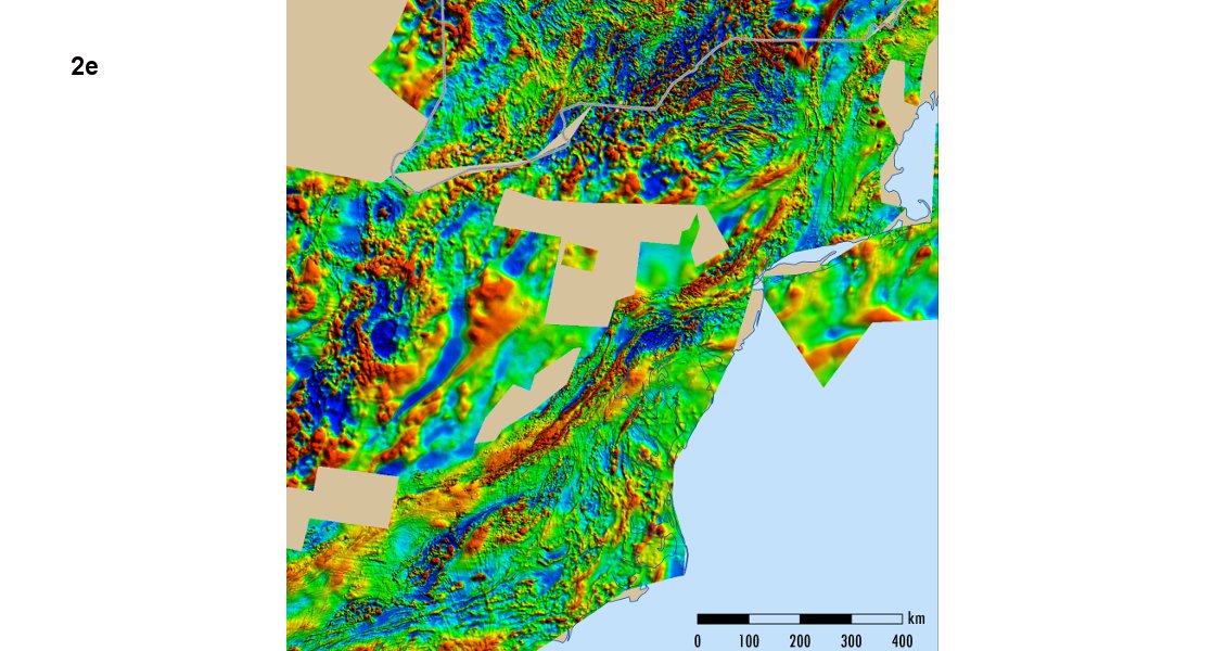
Figure 2: Example from north-eastern USA illustrating the integrated workflow. The Bouguer gravity anomaly (a) is compared against predicted gravity response from the Moho constraint (b) and is low-pass filtered until the maximum cross correlation is achieved (c). This is then inverted for depth-to- Moho (d), which is incorporated as a finite depth constraint when the magnetic data (e) is used for derivation of discrete magnetic depth estimates (f). The high confidence magnetic estimates are used in conjunction with independent constraints (g), before 3D inversions of magnetic (pseudogravity) and gravity data to produce the final integrated depth-to-basement map (h).
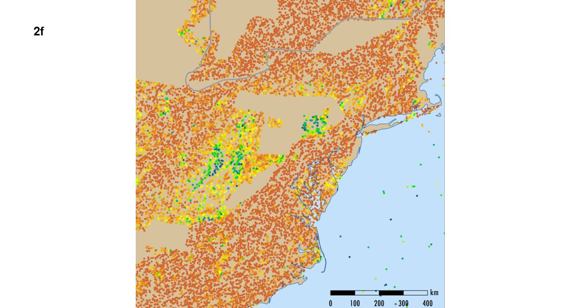
Figure 2: Example from north-eastern USA illustrating the integrated workflow. The Bouguer gravity anomaly (a) is compared against predicted gravity response from the Moho constraint (b) and is low-pass filtered until the maximum cross correlation is achieved (c). This is then inverted for depth-to- Moho (d), which is incorporated as a finite depth constraint when the magnetic data (e) is used for derivation of discrete magnetic depth estimates (f). The high confidence magnetic estimates are used in conjunction with independent constraints (g), before 3D inversions of magnetic (pseudogravity) and gravity data to produce the final integrated depth-to-basement map (h).
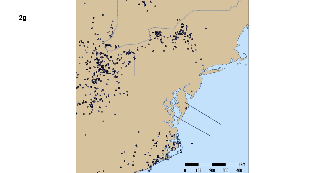
Figure 2: Example from north-eastern USA illustrating the integrated workflow. The Bouguer gravity anomaly (a) is compared against predicted gravity response from the Moho constraint (b) and is low-pass filtered until the maximum cross correlation is achieved (c). This is then inverted for depth-to- Moho (d), which is incorporated as a finite depth constraint when the magnetic data (e) is used for derivation of discrete magnetic depth estimates (f). The high confidence magnetic estimates are used in conjunction with independent constraints (g), before 3D inversions of magnetic (pseudogravity) and gravity data to produce the final integrated depth-to-basement map (h).
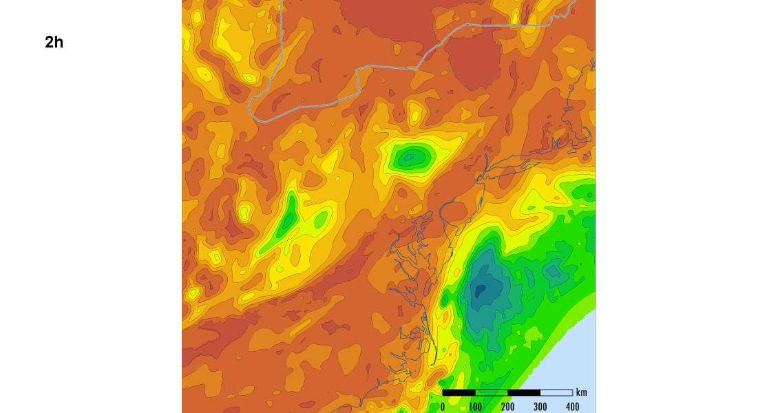
Figure 2: Example from north-eastern USA illustrating the integrated workflow. The Bouguer gravity anomaly (a) is compared against predicted gravity response from the Moho constraint (b) and is low-pass filtered until the maximum cross correlation is achieved (c). This is then inverted for depth-to- Moho (d), which is incorporated as a finite depth constraint when the magnetic data (e) is used for derivation of discrete magnetic depth estimates (f). The high confidence magnetic estimates are used in conjunction with independent constraints (g), before 3D inversions of magnetic (pseudogravity) and gravity data to produce the final integrated depth-to-basement map (h).
Recent Research
Getech’s analysis of the magnetic data incorporates two important elements:
Finite depth extent: This takes into account the fact that the thickness of the magnetised layer will be depth limited and governed by the Curie point, the temperature at which magnetic minerals become non-magnetic. In certain geological settings, for example stretched continental margins, the thickness might be very small compared to the depth-to-magnetic source, and hence will have a significant effect on the depth results, causing them to be underestimated (Flanagan and Bain, 2013; Lee et al., 2010; Salem et al., 2014a). In this project the finite local wavenumber method has been used (Salem et al., 2014a), which requires information about the depth to Curie isotherm. In the absence of computed Curie depths, Getech has used the depth-to-Moho as a proxy for the base of the magnetic layer and has implemented this into its depth-to-magnetic source calculations, a significant improvement over a prior assumption of source geometry.
3D magnetic inversion using pseudogravity: Most magnetic depth methods that estimate solutions at discrete points are often biased towards the top edges of structures. When sampled onto a grid the resultant map often shows a shallower solution, missing deeper intra-basin details. Getech uses high confidence discrete magnetic depths (and other independent control data) to constrain a full 3D inversion to produce the basement surface using the pseudogravity approach (Salem et al., 2014b). This approach has an additional advantage in that the pseudogravity transformation converts a grid of magnetic data so that the resulting grid has the same simple relationship to magnetic susceptibility as the relationship between the gravity data and density, and hence a more straightforward inversion problem.
Crustal Architecture
Using these methodologies it has been possible to map the crustal architecture and produce positive results in a number of geological settings around the world. The results from both the gravity and magnetic data have been integrated with independent constraints to build a global depth-to-basement map. The approach is both technically robust and has allowed implementation in a practical and self-consistent manner. There will inevitably be limitations due to some over-simplification when applied at the global scale; however, at a regional scale, Getech views this as a valuable tool for first-pass basin screening.


