Attacked by the brutal waters of the North Sea for millennia, the cliffs along the coast of Co. Durham, in the north-east corner of England, are made up of a series on carbonate rocks, which are directly analogous to the Permian Zechstein succession in the North Sea. The Zechstein is the main reservoir in the Auk, Argyll and Carnoustie Fields offshore UK and in the UK onshore Malton, Marishes, Kirby Misperton and Pickering fields, as well as in a large number of onshore fields in the Netherlands, Poland and Germany.
Zechstein cycles
 The geology of the north-east England coastal region. Image: BookcraftFour major evaporitic cycles have been identified in the Southern North Sea Basin, each cycle reflecting the influence of increasing salinity caused by evaporation following an initial marine incursion. Each cycle commenced with a thin clastic member, passing upwards in turn through limestone, dolomite and anhydrite to halite and finally to highly soluble salts of magnesium and potassium. The marginal carbonates of the first three cycles, known as Z1, Z2 and Z3, are complex wedges, each thickening for some distance into the basin and then thinning towards the centre.
By starting at the coast at Frenchman’s Bay, just south of the major North Sea industrial port of South Shields, and travelling just 15 km south to Seaham, it is possible to follow onshore the whole story of the first three Zechstein cycles found offshore. This takes us from the Early Permian Rotliegends, and its onshore equivalent, the Yellow Sands Formation, through the Z1 and Z2 main Zechstein carbonate/evaporite sequences and finally to the Late Permian Z3 Plattendolomit Formation, onshore called the Seaham Formation.
The main notable difference between the onshore and offshore sequences is that the thick offshore evaporite horizons are represented onshore by thin solution residues, overlain by brecciated carbonates which have collapsed after the removal of the evaporites.
Complex Geology
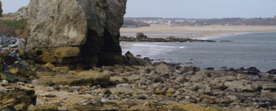
 The Z2 Concretionary Limestone at Marston Bay, consisting of iinterbedded finely laminated mudstones and turbidites, which has been differentially eroded to form high cliffs and freestanding sea stacks, such as this one, known as Lot’s Wife. Photo: Bernard Cooper
 Although at first glance a simple succession, post-depositional sedimentary tectonics have made the interpretation of these rocks onshore a more complex puzzle to unravel, with slumping and sliding resulting from underwater sediment movement, further complicated by secondary chemical changes to the rock material, with dedolomitisation (secondary calcite) solution and subsequent brecciation of overlying sediments all playing a part.
This is shown clearly in the coastal exposure at Trow Point, where slumped Z1 carbonates overlie flat bedded Z1 carbonates (both of the Raisby Formation), and inland at a bend on the River Wear at Claxheugh Rock where the Z1 bryozoa/stromatolite reef has slumped over the underlying Z1 bedded dolomites of the Raisby Formation onto the underlying Yellow Sands as a result of gravitational slumping.
The thick aeolian Yellow Sands Formation was deposited in a desert environment, and internal structure indicates it was probably formed as longitudinal dunes, although the thick Rotleigends sequence in the North Sea would appear to be the product of transverse dunes. It was rapidly inundated by a Late Permian transgression, resulting in the deposition of a thin marl, the Kupfershiefer, known onshore as the Marl Slate, which is less than 1m thick, and is clearly seen as a laminated shale layer at Claxheugh, where it has been eroded back into the cliff face.
This is overlain by the Raisby Formation, a finely crystalline dolomite, exposed at Claxheugh and on the beach at Trow Point, and the Ford Formation, a dolomitised reef and back-reef facies, forming the cliff at Claxheugh, where the massive bryozoan/algal reef core can be seen. These are equivalent to the Z1 carbonates in the southern North Sea, where they are very thin, and where they are overlain by a very thick anhydrite, the Werranhydrit. As can be seen at Trow Point, however, the corresponding onshore horizon is only a few centimetres thick, the result of weathering dissolution.
Collapsed and concretionary limestones
 Bernard Cooper is a highly experienced petroleum consultant with 42 years in the industry, during which time he has worked in most aspects of exploration geology in almost every corner of the globe. He was the leader of the PESGB field trip to look at these reservoir analogue rocks in 2009. Photo: Christian Persson
 The contact between Yellow Sands (Rotliegends eq.) and the dolomite of the Ford Formation reef at Claxheugh. The slope is interpreted as the northern fl ank of a submarine slide canyon, the result of massive, late Permian, submarine slumping. Photo: Bernard CooperThe limestone at the base of the next cycle, Z2, the Concretionary Limestone, has therefore suffered severe deformation and change, brecciated due to both karst and solution collapse, as can be seen at Trow Point. The upper part of the Concretionary Limestone is unbrecciated and is very well exposed in the cliffs in Marsden Bay. It consists of interbedded units of finely laminated pelagic lime mudstone and thicker units interpreted as turbidites, typical of marine mid slope deposition. These fine grained dolomitic mudstones have low porosity and permeability, and where the sediments have suffered dedolomitisation and have a white “nodular ” appearance they have no remaining poroperm.
The upper part of the Z2 cycle is the Roker Dolomite Formation, equivalent to the prolific Hauptdolomit of the Dutch, Polish and German onshore gas and oil fields, which is well exposed along the coast further south at Seaham. In contrast to the underlying slope sediments of the Concretionary Limestone Formation, these shallow water sediments have good matrix porosity and permeability.
Once again the final evaporitic phase of the cycle, which offshore is represented by about 75m of Stassfurt Salze and Basalanhydrit, has been reduced to a much thinner layer of residual contorted calcareous claystones and interbedded thin limestones, known as the Forden Evaporite Formation, which at Seaham is about 9m thick.
It is overlain by the third Zechstein cycle, commencing with the Seaham Formation, the onshore equivalent to the North Sea Plattendolomit, a relatively undisturbed, thinly bedded limestone. This is mostly noted for the many concretions seen in the limestone and as a result was known in the past as the ‘cannonball’ carbonate. These concretions and the thin bedding mean that it closely resembles the Z2 Roker Formation, and indeed has been wrongly identified as that, although the two can be clearly differentiated by the small stick-like remains of the fossil algae Calcinema, which is common in Z3 and absent from Z2. This formation was deposited in an open marine shelf environment, and as the seawater shallowed, stromalites formed, before the cycle again terminated with supratidal sabkhas, which are not exposed onshore North East England.