
When precision becomes a trap
Why more detailed models do not always mean greater geological certainty

In exploration, we spend a great deal of effort making our interpretations more precise. We improve seismic imaging and refine horizon picks. We build increasingly detailed depth maps. We calculate probabilistic volumes and assign geological probabilities to reservoir, charge, trap and seal.
However, there is a subtle danger: The precision of our outputs can begin to exceed the certainty justified by the underlying data.
A useful example comes from the Bauer Field in the Cooper Basin of South Australia. Before drilling in 2011, Bauer was mapped on 3D seismic as a low-relief anticlinal closure with only about 9 m of structural relief. The pre-drill mean recoverable resource was estimated at approximately 0.5 MMbbl of oil. The discovery well subsequently encountered a 14 m oil column, and by early 2015, the estimated ultimate recovery had increased to around 13 MMbbl.
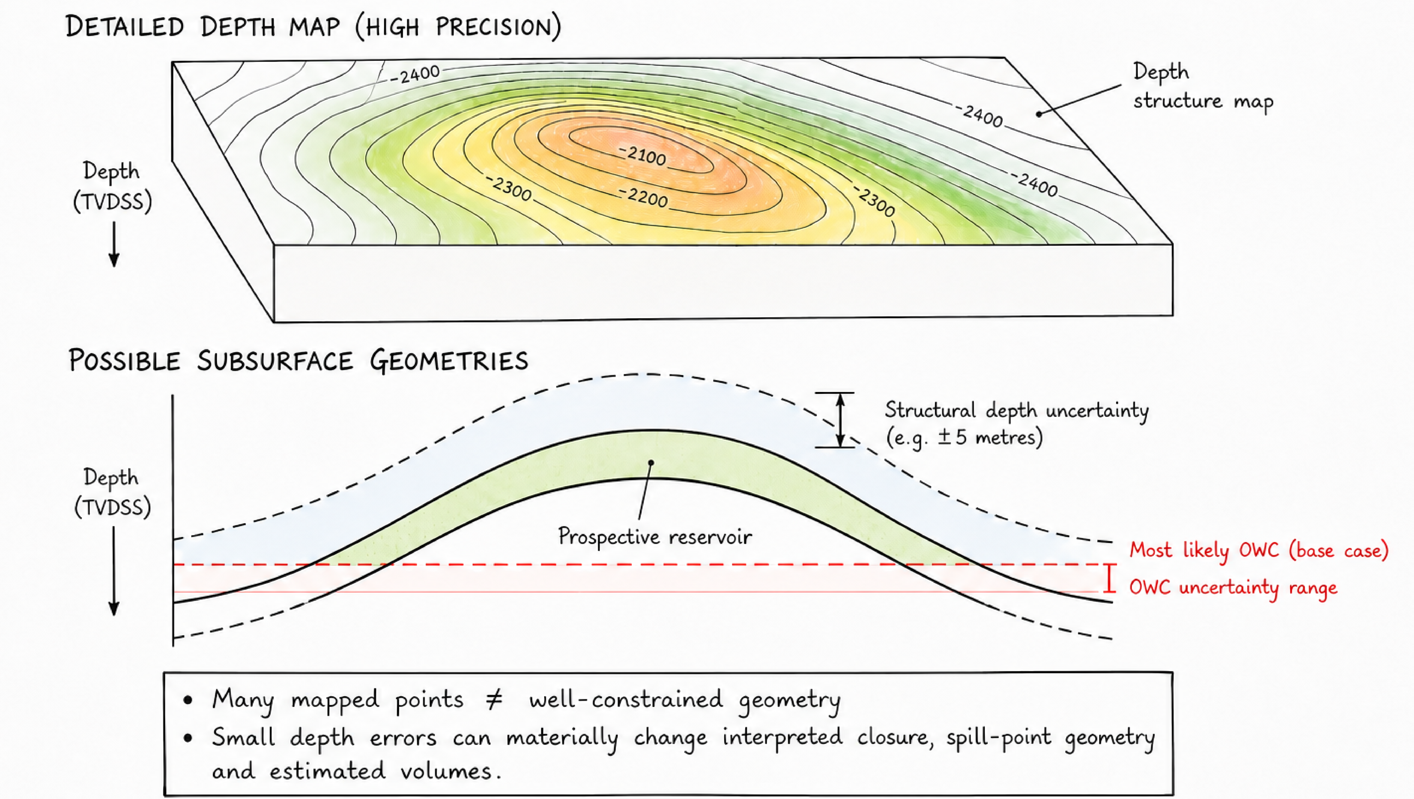
Importantly, this was not simply a case of a poor pre-drill interpretation. Better-than-expected reservoir performance contributed significantly to the growth. At the same time, though, drilling consistently demonstrated an uncertainty of approximately ±5 m at reservoir level. On a structure initially mapped with only 9 m of relief, that matters enormously. That is the essence of the false-precision problem.
A map can be precise and still be uncertain
A seismic interpretation may consist of thousands of carefully picked points. However, every mapped surface contains uncertainty associated with seismic resolution, interpretation, calibration and velocity modelling. This becomes particularly important in low-relief structures, where relatively small depth errors may materially change the geometry or even the existence of a closure.
Work from the Cooper–Eromanga Basin has demonstrated that different depth-conversion approaches can produce materially different structural outcomes, including differences affecting low-relief oil-bearing closures. The map may therefore look definitive while the geological question remains open.
This is not a reason to distrust seismic interpretation. It is a reason to understand what the interpretation can – and cannot – resolve.
And the issue extends beyond one Australian field. A post-well review by TotalEnergies of 90 deep-water Gulf of Mexico exploration wells identified prospect geometry as the principal failure mode. Some wells were drilled outside closure, while other interpreted traps proved incompletely formed, with limitations in seismic imaging identified as an important underlying cause (Schoellhorn & Guerin, 2006).
In other words, a detailed prospect geometry is not necessarily a well-constrained prospect geometry.
Depth conversion is an interpretation too
We often talk about converting a seismic interpretation from time to depth as though it were simply a computational step. However, the relationship between seismic velocity and reflector depth is inherently non-unique. Different velocity-depth models may satisfy the seismic observations while producing different subsurface geometries, particularly where calibration is limited.
Once converted to depth, however, the result acquires considerable visual authority. A complex chain of interpretations and assumptions has suddenly become a beautifully precise map. That precision can be misleading if the underlying velocity and depth uncertainty disappears from the discussion.
The challenge is therefore not simply to produce the best depth map. It is to understand how strongly the available data constrain that map – and which alternative geometries remain credible.
Volumetrics can create the same illusion
Modern probabilistic volumetrics are far superior to relying on a single deterministic case. But probabilistic calculations do not remove geological judgement. Area, thickness, net-to-gross, porosity, hydrocarbon saturation, contact depth and recovery parameters still have to be estimated. The ranges and distributions assigned to those parameters need to reflect the geological evidence and the uncertainty that actually exists.
A Monte Carlo simulation can generate thousands of outcomes with impressive numerical precision, but that does not make poorly constrained inputs more reliable. The important question is therefore not only what the P50 volume is, but also why we believe this distribution adequately represents the geological uncertainty. A probabilistic result is only as meaningful as the geological reasoning behind its inputs, ranges and dependencies.
Getting one prediction right does not validate the whole prospect model
A recent Norwegian Sea exploration well provides another useful perspective. The 6507/4-3 S well tested the Peder prospect on the Dønna Terrace in 2022. The prospect was associated with a Cretaceous amplitude anomaly, and the well location was positioned just inside a subtle four-way-dip closure. The predrill model also required a stratigraphic trapping component to fill the wider amplitude-defined prospect.
The target itself arrived remarkably close to prognosis – approximately 2 m TVD shallow. Yet, the geological outcome was very different from the full pre-drill concept.
Only about 0.5 m of pay was encountered within the small four-way closure, while the remainder of the sandstone interval contained residual hydrocarbons. The Norwegian Offshore Directorate concluded that the result suggested the absence of an effective stratigraphic trap element. Reservoir quality was also poorer than predicted.
This is not an example of false precision in depth conversion. It illustrates that one part of a model can be accurate while another decision-critical assumption is wrong. Landing the reservoir close to predicted depth does not validate the trap model, just as correctly predicting reservoir presence does not necessarily validate charge, seal or commercial volume. That is why prospect uncertainty has to remain decomposed and visible.
Geological risking has the same vulnerability
An exploration team may assign probabilities to reservoir, charge, trap and seal and combine them into an overall geological chance of success. This calculation may be mathematically precise, but the inputs are not measurements. They are structured expressions of geological judgement based on evidence, analogues and experience.
Peter Rose explicitly warned explorationists against false precision in prospect-risk estimates and emphasised the need to challenge individual risk factors, compare assessments with analogous prospects and calibrate estimates against subsequent exploration outcomes. Two competent teams may therefore assign different probabilities to the same prospect without either necessarily being objectively “wrong”.
This is also where systematic postwell analysis becomes particularly valuable. A TGS study assessed Gulf of Mexico wells through an interdisciplinary workflow integrating geology, geophysics, petrophysics, seismic data and basin modelling. Reservoir, trap, seal and charge were assessed individually, while confidence ratings were applied not only to the geological interpretation but also to the available data.
And that distinction is important; a risk assessment should communicate not only what we believe, but also how strongly the available evidence allows us to believe it. The study also illustrates the value of post-well calibration. By examining both discoveries and dry wells, teams can identify recurring reasons for success and failure and use those lessons to improve subsequent exploration assessments.
This closes an essential loop of prediction, outcome, learning and recalibration. Without that loop, probabilities risk becoming internally consistent numbers that are never tested against reality.
More computing power can amplify both insight and confidence
None of this is an argument for less sophisticated seismic imaging, simpler models or less quantitative analysis. Advances in seismic processing, modelling and computing allow us to constrain the subsurface more effectively and examine geological hypotheses in ways that were previously impossible.
At the same time, increasingly sophisticated models may become visually and numerically more convincing. A model can therefore become more detailed, more internally consistent and more visually persuasive – without necessarily becoming proportionally more geologically certain.
The risk is that computational sophistication may be mistaken for independent geological validation. This distinction becomes increasingly important as exploration workflows incorporate automation, machine learning and AI-assisted interpretation.
These tools may identify patterns that are difficult for an individual interpreter to recognise, but their outputs still need to be considered in the context of data quality, calibration, geological plausibility and credible alternative interpretations. Technology is most valuable when it helps us test and challenge our geological understanding – not merely when it makes the preferred model more detailed.
Precision is valuable – provided we keep asking what it means
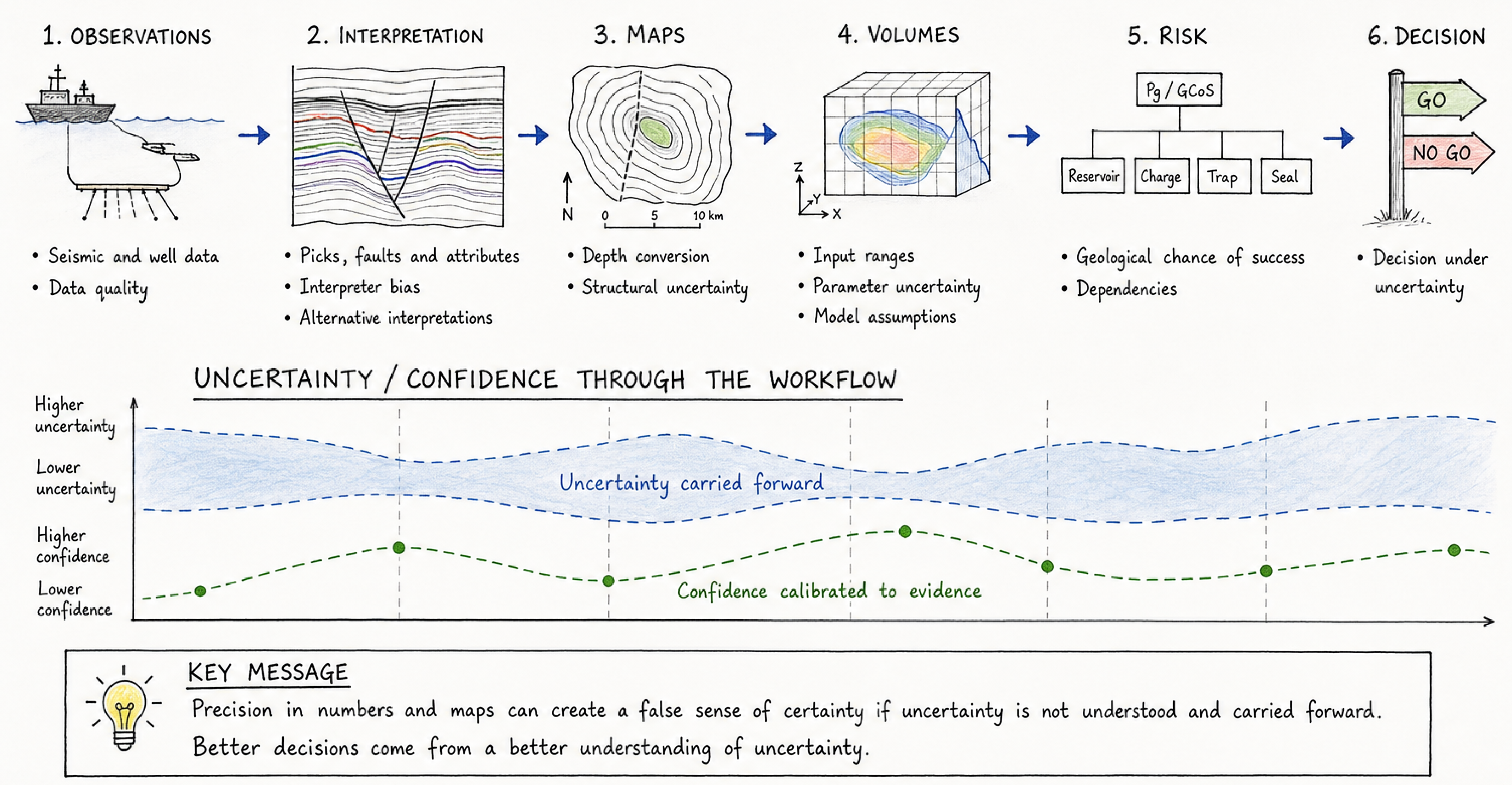
The solution is not to avoid quantitative methods, but to maintain a clear distinction between observations, interpretations, assumptions, uncertainty and confidence. A particularly useful question during any prospect review is: What evidence would make us change our interpretation? If the answer is unclear, we may be more attached to the model than the evidence warrants.
Bauer provides an example where a few metres of structural uncertainty mattered enormously for a low-relief accumulation. The Gulf of Mexico post-well studies demonstrate the value of understanding recurring failure modes and calibrating interpretation and risk against actual drilling results. Peder shows that getting one element of the prognosis right does not necessarily validate the integrated prospect concept.
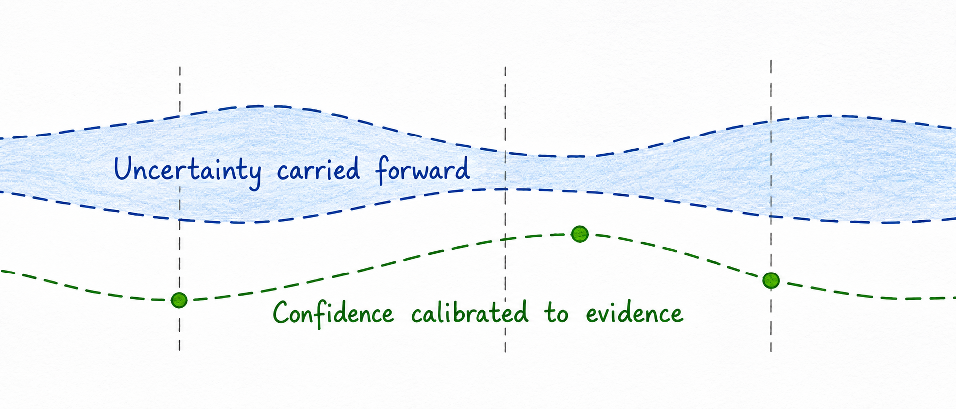
Different settings, but the same underlying lesson: Uncertainty should remain visible as observations become interpretations, interpretations become maps, maps become volumes, volumes become risks, and risks become decisions.
Confidence should follow evidence
Exploration will always involve uncertainty. Better seismic data, better models, better statistics, and better computing help us understand and reduce it. But they do not eliminate it. The danger begins when increasing numerical or visual precision is interpreted as increasing geological certainty. Perhaps the most important question therefore is not: How precise is our model? But rather: Is our confidence proportional to the evidence? In exploration, that distinction can be the difference between a sophisticated model and a robust decision.