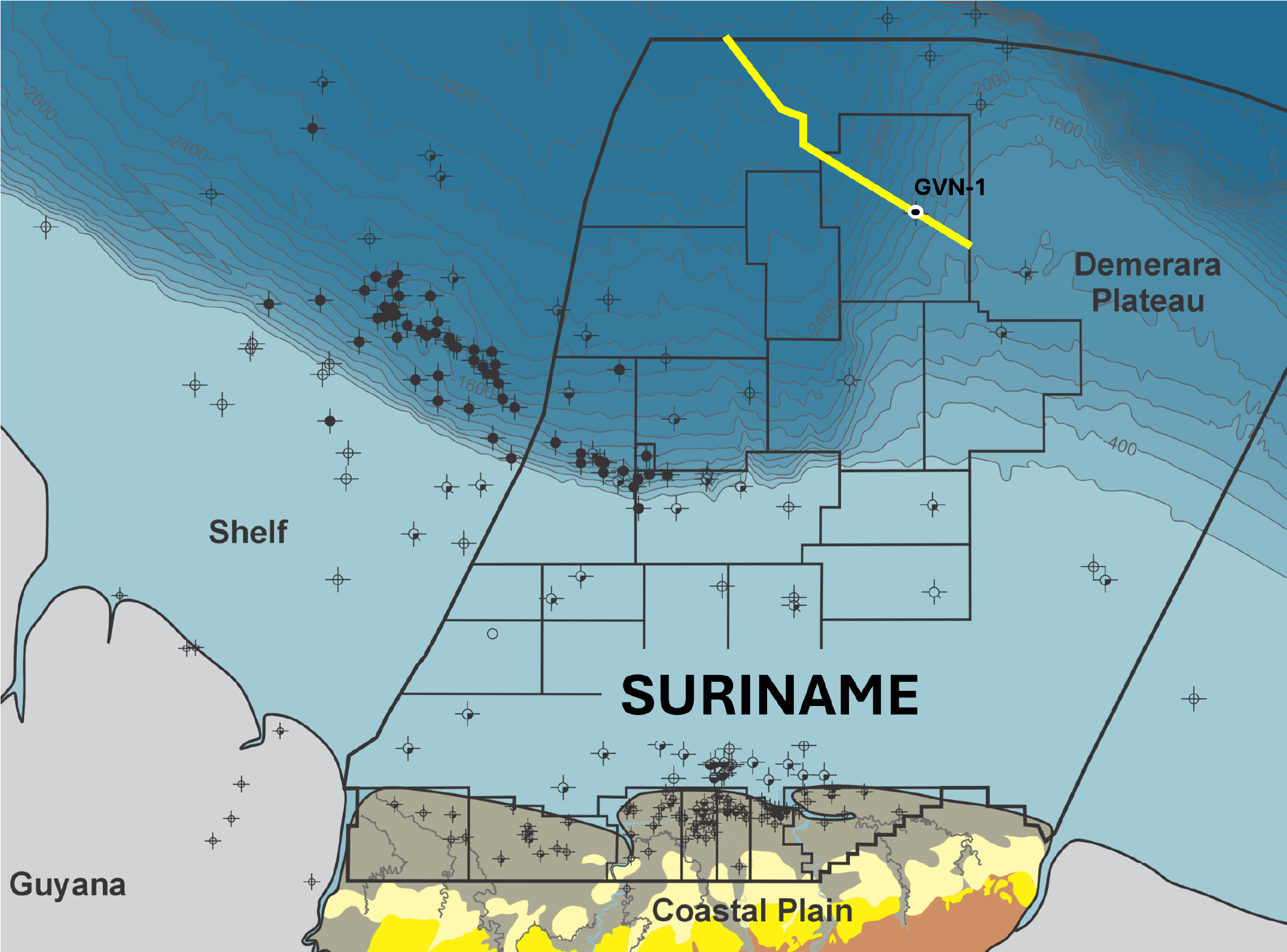
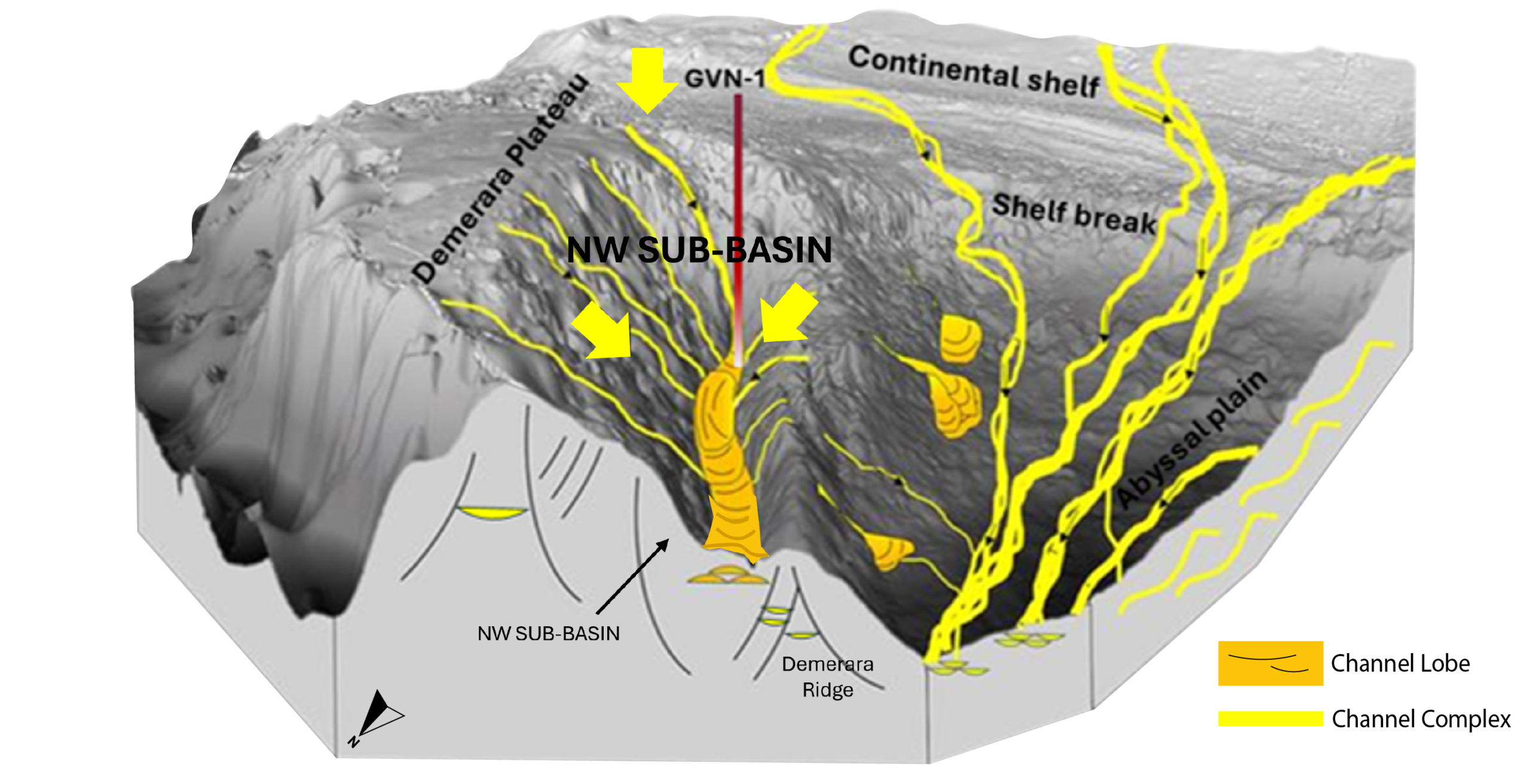
For nearly a decade, the oil and gas industry has obsessed over the hunt for repeated deepwater success of Suriname-Guyana’s “Golden Lane”. In Suriname, there is an unexplored play within the acreage offered in the open-door round. It relies on the same hydrocarbon systems and trapping styles as the Golden Lane, drawing its sands from deltas to the southeast and the shallow marine shelf of the Demerara High. This extension or “replication” of the Golden Lane will be the next great play to chase. “Trendology” is often derided as an exploration strategy until it is apparent that a trap style in a regionally working play system is in fact repeating, and then everyone jumps in. Stepping out from success, though, where key risk elements may be subtly yet crucially changing, is still uncomfortable, and only a seismically de-riskable play can be followed comfortably until the play stops, or, more crucially, until the seismic stops. This was remarkable, with repeatable success coming from the seismic response to rock physics. 3D seismic showed negative amplitude reflectors at the top of the reservoir, bright amplitudes at near offset, and a strong amplitude increase with offset (Class III AVO anomaly). In addition, a hydrocarbon water-contact indicator – a flat spot, or polarity change at OWC can often be seen. The 3D seismic over the Golden Lane is good enough to reduce false positives, making this a seismically de-riskable play. Yet, although the seismic squiggles are the symptom we diagnose for rapid repeatable success, they don’t make the play work. The geology makes the play work. The “Golden Lane” trend is a 250 km long by 50 km wide NW-SE oriented stratigraphically trapped multi-channel play that has been explored extensively from Guyana into Suriname to the point where the Guyana escarpment meets the North-South edge of the Demerara Plateau. Down- and up-dip tests (Joe and Jethro (2019), Tanager, Carapa and Bulletwood (2020-21)) have not been proven to work commercially yet, though we all travel hopefully. So, why does the Golden Lane specifically work? Stratigraphic channel plays are notoriously risky, requiring each channel to have an up-dip barrier to oil migration, and this barrier – a fault or gap in sand connectivity is often desperate to image on seismic. So, how has something subtle occurred repeatedly along a 250 km long margin? In 2021, Bryan Cronin proposed that the Golden Lane deposystem can be interpreted to be controlled by steep bypass channels on structural ramps with intervening lower relief terraces. Sands were not deposited on the steep ramps, and sand deposition only took place at the break of slope onto the terraces where poorly confined amalgamated beltway frontal splay systems and ponded intra-slope lobes accumulated in either levee or erosionally confined canyons. Further out, large-scale frontal splay complexes with MTD (Mass Transport Deposit) controlled stratigraphic or combination traps characterise the basin floor. The stratigraphic repeatability of the Golden Lane then is a function of the geometry of the slope: The steep ramp and flatter terrace geometry. Following the Golden Lane into Suriname, where it converges with the Demerara Plateau, might have seemed like the final chapter for this prolific trend. But in reality, the Golden Lane story is far from complete. Offshore Suriname presents a geological ‘game of two halves’ – a western, deep basinal half (Suriname-Guyana Basin) and an eastern half (Demerara Plateau) where basement is much shallower with thick Jurassic-Lower Cretaceous sections and thin Upper Cretaceous sections. What divides these two is the north-south trending western flank of the Demerara Plateau. To understand these basins, we can lean on the insights from current explorers on the margin, particularly from Staatsolie, the State Oil company of Suriname who have heroically provided the industry with an insightful summary of the Suriname hydrocarbon system for all to use, accessible (QR 1). Figures 1 and 2 give examples of regional depth structure mapping and reservoir facies distribution from the GeoAtlas. About 250 km offshore along the west Demerara Plateau lineament lies the “Demerara Ridge” – a steep, internally complex ridge verging NE. On the SW side of this ridge is the Suriname-Guyana Basin in all its golden-lane glory, yet on the NE side of this ridge is the “NW Sub-Basin” – as yet an unexplored ramp-terrace. The ridge itself is often described as an olistostrome-type gravity slump, yet from its similarity to Eastern Tano or Western Ceara transform margins, this may represent an Albian strike-slip “Demerara Fracture Zone”, deforming thick Aptian sediments during late syn-rift and drift separation from Africa. Regardless of its precise origin, the ridge has played a critical role in shaping regional sedimentation and from the Albian through the Late Cretaceous, sand systems coming over and off the Demerara high were consistently funnelled into the NW Sub-Basin. The NW Sub-Basin has a steep SE Ramp, where the GVN-1 well was drilled (oil and gas shows in Albian sandstones), leading NW to a terrace, i.e. precisely the depositional geometry of the Golden Lane. According to the Staatsolie GeoAtlas, this setting has repeatedly acted as a conduit for sand delivery, not just since the Late Jurassic but crucially throughout the Late Cretaceous as well. Sands sourced from the SE, or derived from the sand-rich Demerara Shelf, were transported down the steep bypass ramp past the GVN-1 location before being deposited on an as-yet unexplored terrace at the slope break, as also documented by and pre-imagined by Max Casson and co-workers in their fascinating 2021 study (QR 2). At the far NW end of the Sub-Basin there is structural and depositional dip reversal in the Upper Cretaceous – a perfect complement to the Golden Lane depositional geometry. The Staatsolie GeoAtlas demonstrates that the source rocks evaluated for the rest of the Golden Lane are present and oil generative under/in the NW Sub-Basin. Aptian and Cenomanian Turonian (ACT) source rocks, among others, are present at depths exceeding 3 km and are oil-generative within this basin. In the northern part of the NW Sub-Basin, we find 1-2 km of stacked Tertiary MTDs, the tail end of the gravity systems pouring from the Guyana-Suriname Shelf to the SW, related to the dynamic topography or simply the rise of the Andes above subduction. This is the cherry on the hydrocarbon system cake, as rapid thermal blanketing from MTD’s help keep the NW Sub-Basin warm, and this is responsible for making the NW Sub-Basin such a prime target. All key exploration ingredients for a Golden Lane extension appear present in the NW Sub-Basin, with one notable exception: the absence of 3D seismic coverage across the northern terrace, particularly over Block 59 (currently open acreage in the 2025 licensing round). In response, Searcher proposes to acquire Multi-Client 3D here in 2026 on a very simple premise: To demonstrate that the geology supports an extension of the Golden Lane to the north in the NW Sub-Basin, by verifying the seismic signature of oil in Upper Cretaceous sands. So, is this Golden Lane extension or replication a perfect seismically driven play that needs to be drilled? – In 2026, we intend to acquire the 3D and find out.
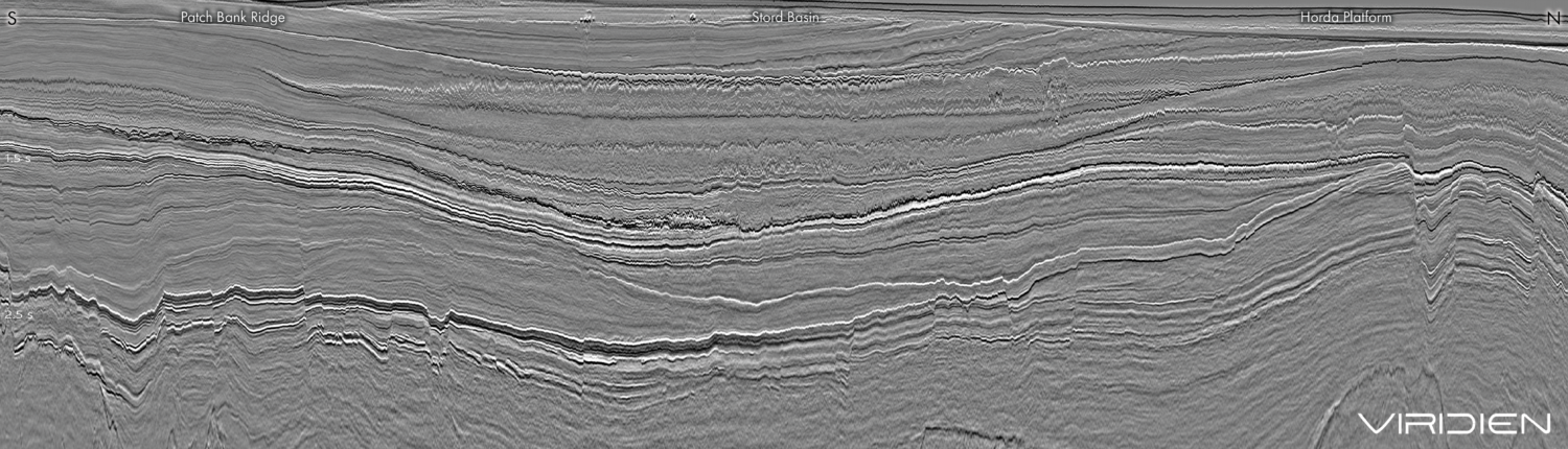
Inside every Basin you know is another Basin you haven’t met
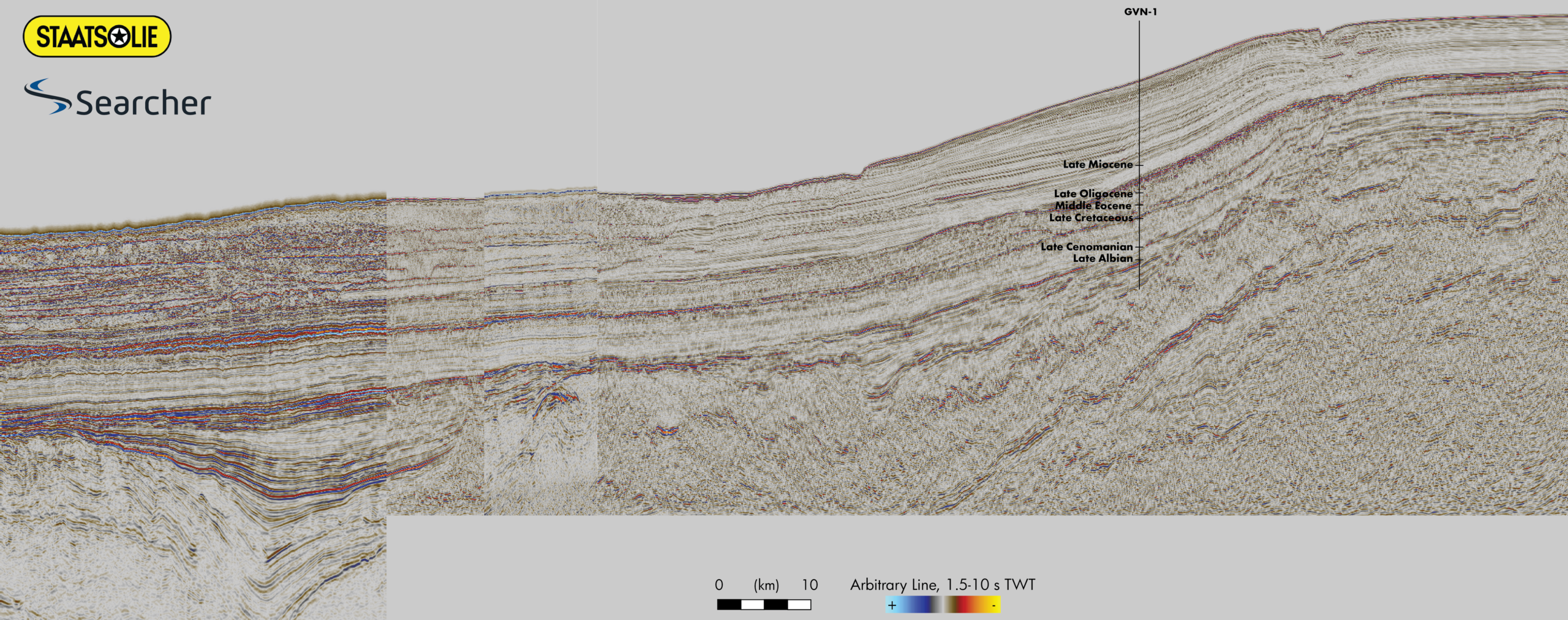 532 km NW-SE traverse through the nadir of the NW sub-basin. The NW section showing a thick Cretaceous section in counter regional dip, above Jurassic, Aptian and C/T source rocks.
Suriname’s north west sub-basin: An extension to the Golden Lane
 After the unassuming discovery of Liza-1 in Guyana in 2015, the Guyanan “Golden Lane” was quickly extended with many other discoveries, all within the same Upper Cretaceous slope fan system. Exploration momentum continued into Suriname, where multiple successes again followed.
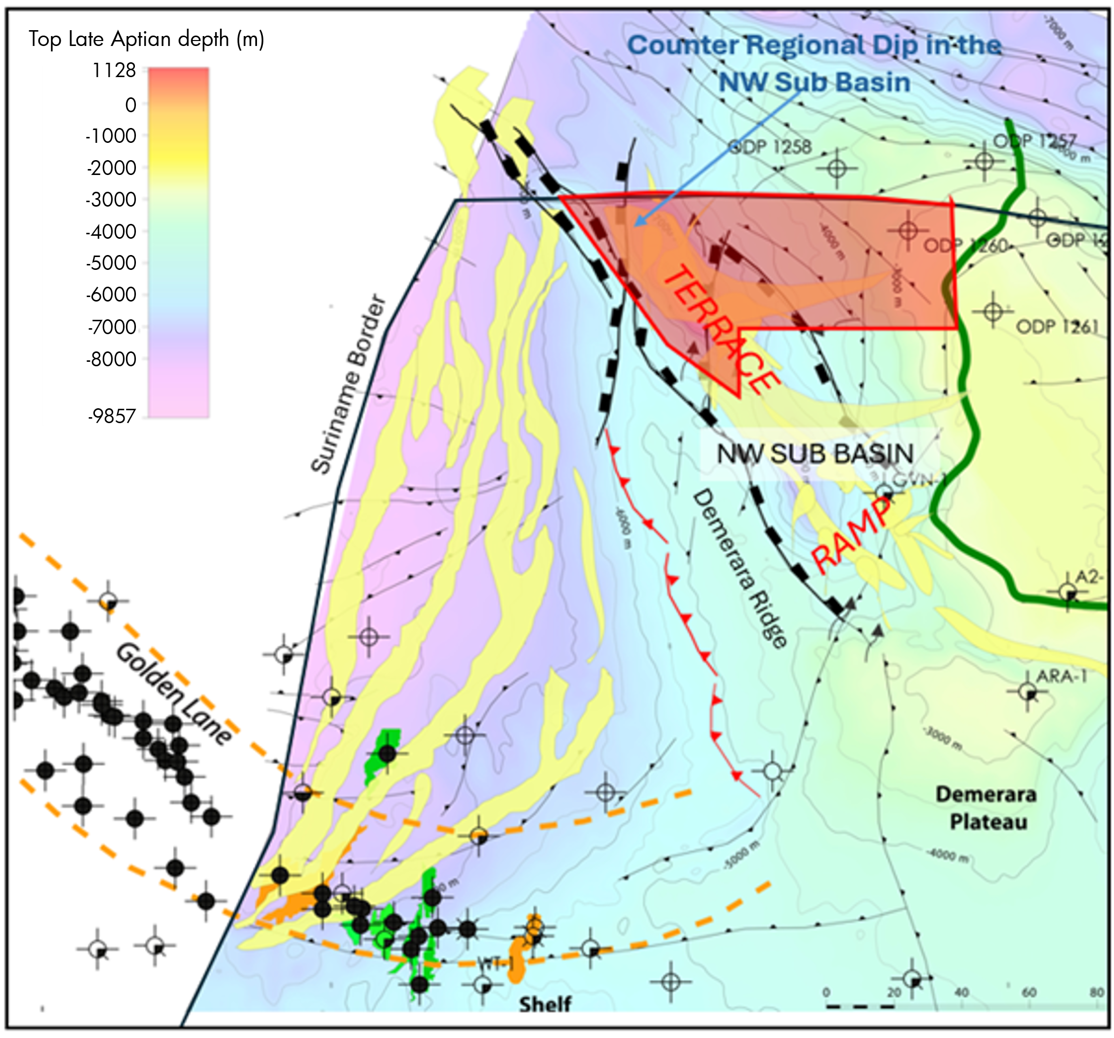
Related Articles