
Somalia: The final frontier?
Like the crew of the Starship Enterprise, explorers in the deepwater acreage offshore Somalia must Go Boldly, and largely where None have Gone Before…but as was proven over and again in Star Trek, the rewards of taking those bold steps could be socially, scientifically and financially significant.
At the outset of a project in the area, one has to ask “Why does offshore Somalia remain unexplored?” It is one of the last undrilled frontier basins in the world, and is physically one of the more accessible. It has a regional database of good-quality sparse 2D seismic data which has been the basis of a number of publications pointing out that it is a margin with significant potential, albeit one with more “above-ground issues” than many.
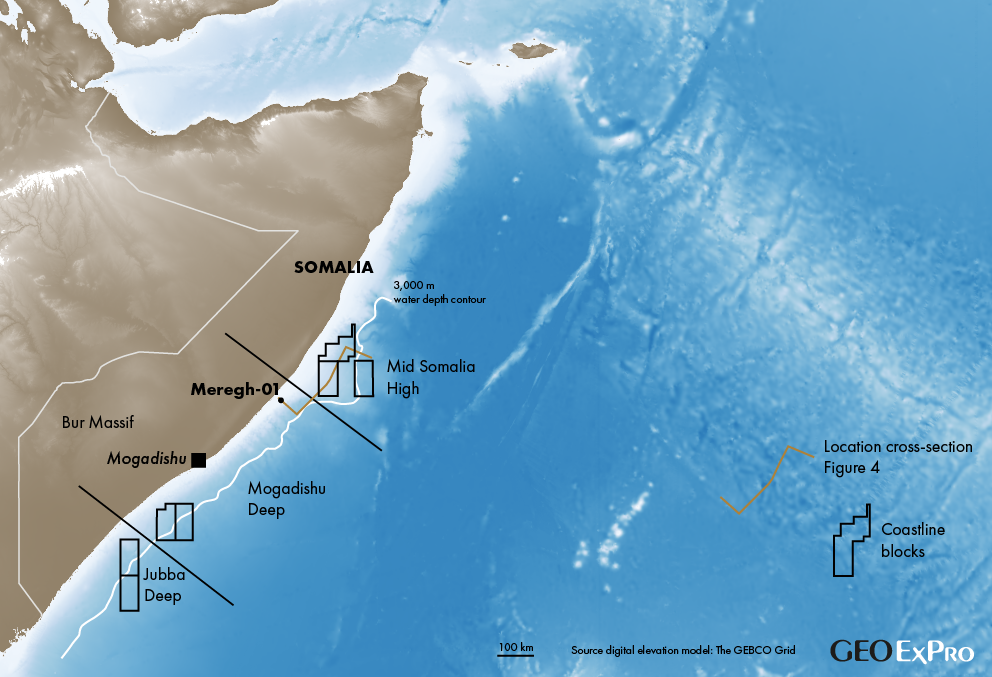
The technical team at Coastline Exploration set out to analyse the margin, where Coastline holds 7 PSA licences (Figure 1), with a skeptical mindset. Our question: “Can a fresh look at the basin reduce the technical uncertainties to a degree that will counterbalance the socio-political and “sanctity of contact” risks for potential partners?”
Source rock biggest uncertainty
The greatest subsurface uncertainty has always been considered to be the presence of a source interval, as none have been penetrated in the basin. However, there is indirect evidence for a working petroleum system: gas and liquids have been tested in onshore coastal wells which, given the basin geometry, can only have migrated from the offshore. In addition, gas chimneys and shallow gas accumulations are observed on 2D seismic data. Our first step therefore was to re-examine the evolution of the basin to see when and if appropriate conditions may have been present for source rock deposition.
Most prior work has emphasised basin evolution through Late Triassic to Early Jurassic via a mechanism of “transtensional” rifting, with the subsequent development of a Middle Jurassic transform margin, and does not make a particularly persuasive case for extensive source deposition under restricted conditions other than during early continental rifting.
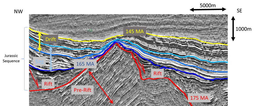
Leveraging a prior working relationship, Coastline worked closely with the University of Texas “Plates” consortium to develop a model that produced a better local fit, utilising the constraints provided by our interpretation of the 2D dataset and regional magnetic anomaly data (Figure 2). The seismic interpretation of rifting and accommodation space development in the Mogadishu Deep and contemporary continental extension in the Mid-Somalia High, combined with the integration of the earliest dated anomalies (145 Ma) marking the locus of initial organised oceanic spreading, permitted recognition of orthogonal rifting for a period of at least 30 million years. Rift initiation in the Early Jurassic (175 Ma), was followed by a sag phase in the Middle Jurassic (161 Ma), and the drift phase, lasting through to the end of the Jurassic (145 Ma) when oceanic spreading was established (Figure 3).
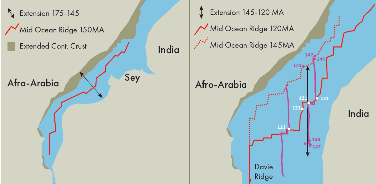
The model predicts a basin closed off to the south with restricted connection to the open Tethyan ocean to the north as a result of the “buttress” of the Mid-Somalia High: in short, ideal circumstances for source-rock deposition over a prolonged period until the establishment of the transtensional margin as the Davie Ridge developed and Madagascar moved away to the south.
50 to 70% chance of success
The counterpart basin to the southern sector of the Somalian offshore, the Majunga Basin in Madagascar, provides a compelling analogue for source deposition, with documented high-quality Early to Middle Jurassic source rocks being the demonstrable source for hydrocarbons in the basin.
Given the modelled early basin evolution, mapped basin geometries of rift, sag and drift intervals, evidence of migrated fluids on the basin margin, and the evidence for source-rock deposition along the counterpart margin, we assess the likelihood of source presence in the basin using a Sherman-Kent methodology, as “more likely than not”, with a 50 to 70% chance of success.
Trillions of barrels
The Jurassic rift-sag-drift sequences were mapped on the depth-converted 2D seismic lines as having thicknesses in the range 0.75 to 1.5 km. A stochastic modelling approach utilised Zetaware Trinity® software to test the basin potential for “total fluids generated”. With conservative assumptions for viable source-rock thickness, HI, TOC, source kinetics and geothermal gradient, output ranges demonstrate that the basin has the potential to have generated multiple trillions of barrels of oil-equivalent. Present-day, the Mogadishu Deep models as mature for gas, and the northern Mid-Somalia High as oil-mature.
The next question to be answered was that of volumetric materiality. Although the counterpart Majunga basin has a prolific proven source rock, there are no discoveries of sufficient materiality to “open” the basin. However, there is a significant “tar belt” onshore where migrating hydrocarbons migrated updip without encountering volumetrically-significant trapping structures.
A significant difference
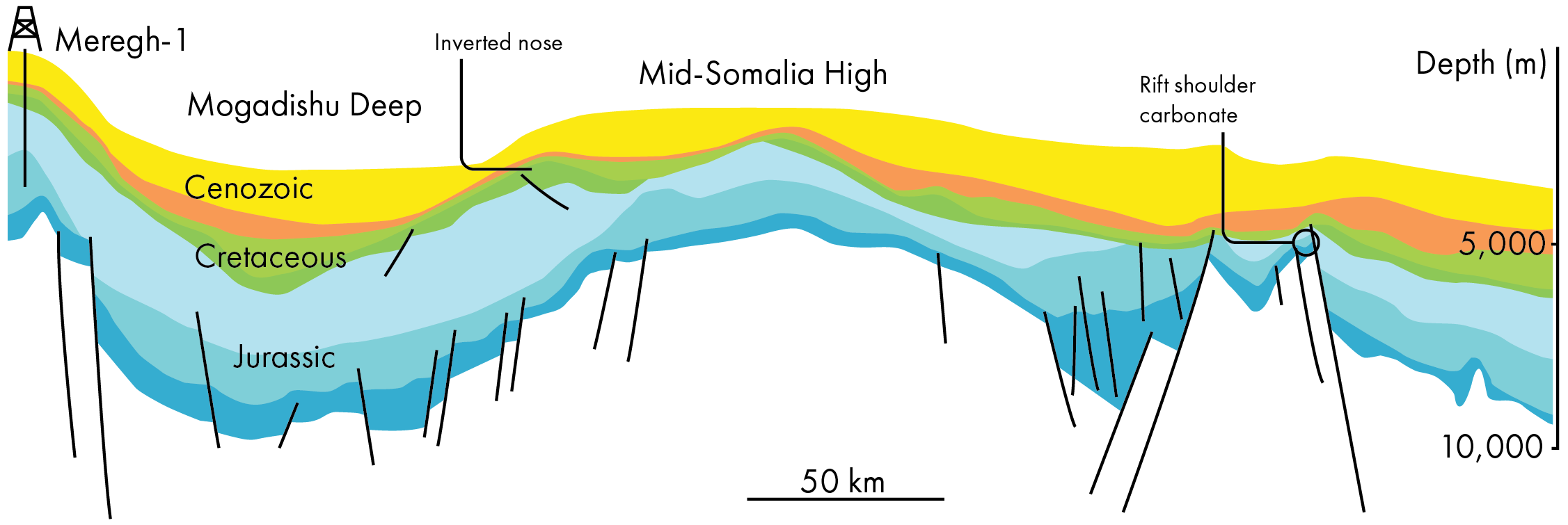
One significant difference between deepwater Somalia and offshore Madagascar is a phase of inversion tectonism beginning in the Early to Middle Cretaceous, and culminating in the Early Paleogene. In its earliest incarnation, it is seen as the uplift and erosion of rift shoulders in the Mid-Somalia High. It manifests as a large inverted nose in Cretaceous sediments of the Mogadishu Deep, and in the Early Paleogene as major uplift of the Bur Massif, inboard of the Mogadishu Deep basin (Figure 4).
The sparse seismic grid makes it difficult to pinpoint the lineaments upon which the inversion was centred, but they clearly run perpendicular to the basin margin, so are likely to be either reactivated transfer zones from the original rift and/or reactivated transforms from the early oceanic spreading. Inversion was driven by compressional forces generated as first India and then The Seychelles separated and drifted to the northeast. Madagascar did not experience these bouts of compression. These episodes of inversion created large migration-focusing structures in the Mogadishu Deep in particular.
A working petroleum system
Our conclusion is that the long-standing concerns over the presence of a working petroleum system in deepwater offshore Somalia are, within the bounds of uncertainty that would be expected in any frontier basin, unfounded. Furthermore, the rift to passive margin sequence in the basin was perturbed by several phases of inversion in the Cretaceous and Paleogene, resulting in the development of large, migration-focusing structures where reservoir fairways have been recognised in thick Jurassic carbonates in the Mid-Somalia High, and in Middle/Upper Cretaceous and Paleogene intervals in the Mogadishu Deep Basin.
Revisiting the question we posed at the beginning of this article, we have concluded that offshore Somalia has all of the characteristics of a prolific, multi-billion barrel province. As a result, Coastline Exploration is on the cusp of authorising a 14,000 km2 3D seismic survey in the Mid-Somalia High to allow us to define drillable prospects, with plans to follow up in the Mogadishu Deep. We are seeking partners to join with us to test those prospects with the drill-bit in 2025.
Suggested reading
Davidson, L.M., Arthur, T.J., Smith G.F., and Tubb, S. (2018): Geology and hydrocarbon potential of offshore SE Somalia. Petroleum Geoscience, 24, 247-257
Davison, I., and Steele, I. (2018): Geology and hydrocarbon potential of the East African continental margin: a review. Petroleum Geoscience, 24, 57-91
Hodgson, N., (2016): Somalia Awakens as East Africa’s Oil Province: New Seismic Data Shows Clear Prospects. Offshore magazine, 12/2016
Kearns, H., Berryman, J., Hodgson, N., and Rodriguez, K. (2016): Somalia’s Exploration Journey. GEO ExPro 2016, Issue 2, 53-54


