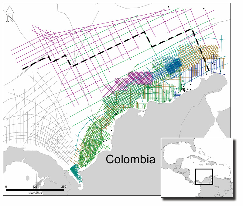
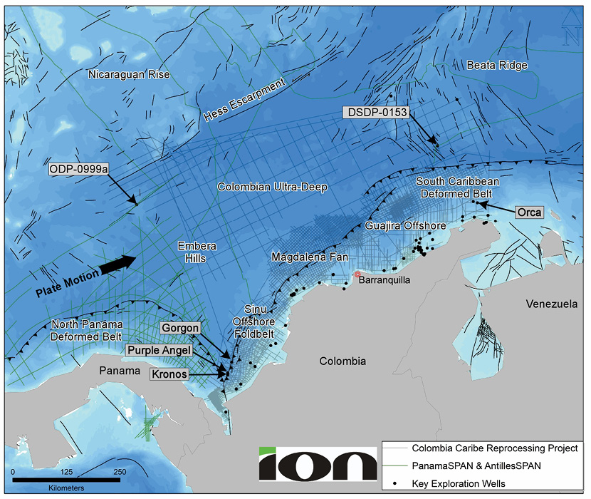
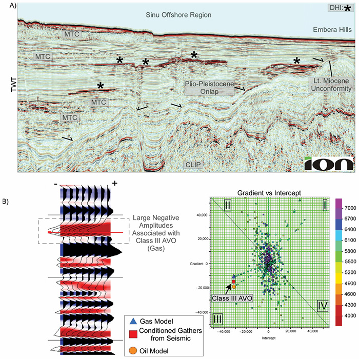
ION’s newly reprocessed ~60,000 km 2D seismic data provides the ideal platform to support renewed exploration efforts in Colombia after recent gas discoveries. The Pre-Stack Time Migration (PreSTM) seismic section, seen below, is the result of modern, proprietary workflow applications. Eighteen vintage surveys that make up this project are now a single, contiguous survey. This work has revealed key details of the Caribbean Large Igneous Province (CLIP) and the southern transition to the South American margin. Key regional units and unconformities can now be mapped with a higher confidence for a better understanding of the tectonostratigraphic framework. In the southern region of the basin, internal features are now imaged in the structurally complex Sinu Prism and the South Caribbean Deformed Belt. Initial observations include a well-imaged Moho across the Colombian Basin, which now allows for a better understanding of the CLIP’s crustal architecture. Colombia’s offshore potential has been highlighted by recent discoveries in the deepwater sector. Petrobras’s Orca gas discovery was the first significant find in 2014, followed by Anadarko’s Kronos, Gorgon, and Purple Angel gas discoveries from 2015 to 2017. These exploration successes have renewed the interest in offshore Colombia with many operators targeting analogue structures along the margin in the hope of similar discoveries. Recently, ION partnered with Colombia’s National Hydrocarbons Agency (ANH) to reprocess and depth image the entire 2D seismic database in offshore Colombia. This undertaking has resulted in significant uplift of the data quality and has revealed new insights about the northern margin of Colombia and the Caribbean Plate. The project extends over 60,000 line-km from 18 surveys acquired between 1982 and 2014 with varying record lengths and acquisition parameters. The Colombia Caribe data covers much of the central and western Caribbean (Figure 1). The contiguous framework provided by this project now seamlessly connects the major exploration areas and play fairways. Unlike many offshore basins, the Caribbean is highly complex and is considered to have active margins on all sides. This setting results in the formation of fold and thrust belts and subduction zones (Figure 1). The transcurrent motion of the Caribbean Plate along the Colombian margin has created the Sinu Accretionary Prism and the South Caribbean Deformed Belt (SCDB). The Colombia Caribe data covers the majority of the central and western Caribbean (Figure 1). Exploration in the Caribbean has always been challenged by the lack of ability to constrain data points across the basin. The regional transect (Figures 2a and 2b in the main foldout) highlights the basin architecture between the ODP-0999a and the DSDP-0153 boreholes and the importance of constraining data points across the basin. This is a significant step forward, as these are two important locations that provide stratigraphic ages for the region. Additionally, understanding the basement framework has been hampered by the lack of crustal-scale imaging using vintage data. By using the reprocessed data, a complete and accurate assessment may be performed. The approach to the reprocessing of vintage seismic data has been proven repeatedly as a strategic means to revisit and de-risk frontier basins. The processing can be split into separate parts for the Colombia Caribe Project: signal processing and velocity model building/imaging to produce the pre-stack time migration (PreSTM) and pre-stack depth migration (PreSDM) products. The two key factors within the signal processing stage to help improve the data quality were: 1) ION’s experience with reprocessing older, multi-vintage surveys and 2) the application of modern demultiple and deghosting techniques to produce cleaner, broader frequency sections when compared with the legacy data. During the PreSDM velocity model building, the aim is to produce geologically consistent velocity models that would tie across all surveys and lines over the region. ION’s 2D imaging workflow takes into account all the line ties and pseudo 3D velocity models that are created during model building to ensure lines tie correctly at intersections. This, along with incorporating well and gravity data and the interaction between ION’s geologists and geophysicists, were key in producing the PreSDM images. Legacy data near the SCDB captures the down-going Caribbean Plate at the South American margin (Figure 3a). This vintage seismic profile illustrates the exploration challenges associated with using legacy data that lacked a high quality image of the subsurface. Figure 3b is the 2021 reprocessed two-way-time (TWT) version of the line. The uplift of the data is clearly visible and exemplifies the value in the reprocessing approach. Figure 3b shows a traceable Moho at the base of the CLIP being obliquely subducted under South America – a feature that has been absent from 2D seismic data in the Caribbean, until now. Intra-basement faulting of the down-going Caribbean Plate is now imaged and the variability of crustal thickness can be assessed across the basin. Crustal flexure in this oblique subduction setting can now be more accurately assessed with the basement architecture details revealed. Included in the processing uplift is a clear basal-stratigraphic-unit/basement interface. This contact boundary is critical to understanding the Caribbean region, as nearly all of the CLIP is capped with volcanic flows related to the Galapagos Hotspot interaction in the Pacific Ocean. The northern margin of Colombia hosts very complex geology in terms of stratigraphy and structure. Figure 4 highlights the intensely structured region of the Guajira region where mini basins were formed between folds and thrusts. The bottom-simulating reflector (BSR) is also a common feature, possibly indicating the presence of gas hydrates. Progressive deformation occurs as the Caribbean Plate continues to move eastward relative to the South American Plate and creates excellent trapping geometries for exploration along the entire transition zone. Direct hydrocarbon indicators (DHIs) are a common feature in offshore Colombia represented by seismically bright amplitude anomalies, as shown in the Sinu Offshore example (Figure 5a). These anomalies are commonly present at fault discontinuities, pinch-outs or on structural features. An AVO (amplitude variation with offset) analysis is the next step to determine the presence of hydrocarbons in a reservoir-bearing unit through qualitative interpretation of these DHIs. This is performed through a seismic gather-scaled evaluation to differentiate between a brine and an oil/gas-filled reservoir. In this case, a more accurate interpretation of the results is aided by the improved quality of the conditioned seismic gathers and the integration of well data. Results from one analysis shows a strong Class III AVO, indicating the presence of oil/gas within a reservoir unit (Figure 5b). This is an important result, as it further supports continued exploration in Colombia and modernised seismic indicate that these targets are plentiful in the basin. The benefits of a regional scale, internally consistent and cohesive seismic and velocity framework have been proven repeatedly. The success of the vintage seismic reprocessing efforts and the AVO results presented here, illustrate the potential for continued exploration successes in the coming years from the Colombian Basin. A few recent GEO ExPro articles by ION that you might be interested in: Explore the Mid North Sea High Revealing the Intra-Zechstein Hydrocarbon Prospectivity on the UK Mid North Sea High This article appeared in Vol. 18, No. 2, 2021, and featured as online Sponsored Content in September, 2021.
Offshore Colombia: discovering new value in legacy data using modern workflows
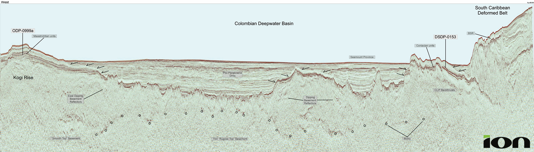 Figure 2b: Regional transect line across the Colombian Basin, tying the ODP-0999a and DSDP-0153 research boreholes.
Newly integrated 2D data highlights the prospectivity of offshore Colombia
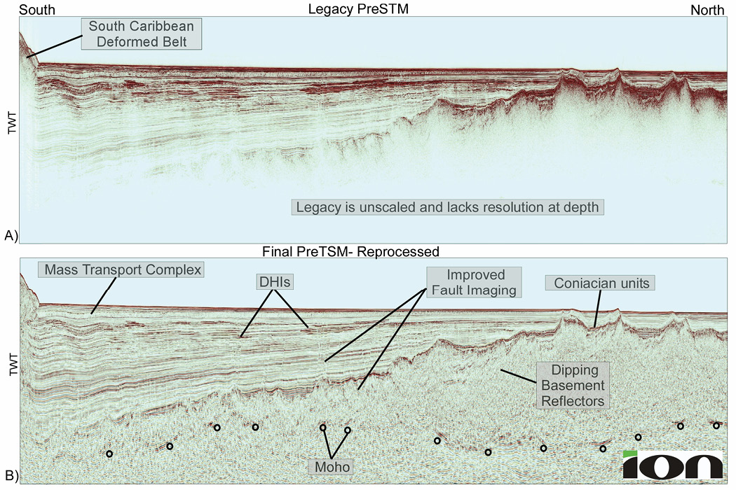
Legacy vs. reprocessed data

DHIs and AVO analysis
Further reading
ION
MNSH PRIME 3D is a multi-client new acquisition program from ION Geophysical that covers approximately 11,700km2 of the UK Continental Shelf (UKCS).
This article featured as online Sponsored Content in May, 2021
Paul Bellingham, Will Reid, Emily Kay and Neil Hurst; ION
A newly acquired 3D seismic survey, covering the entire Zechstein play fairway in the UK Mid North Sea High, reveals the hydrocarbon potential of the complex and highly variable Intra-Zechstein plays on the flanks of the European Permian basin.Related Articles


