A Journey of a Thousand Miles: Lebanon’s Offshore Hydrocarbon Potential
Following the drilling of the first ever exploration well in the Lebanese offshore, in 2020, Lebanon’s hydrocarbon marathon begins. This article takes a closer look at the hydrocarbon system and future potential.
First Step to Success
Drilling of the first ever exploration well in the Lebanese offshore began on March 3, 2020 and was completed on May 8, 2020 using Vantage Drilling’s Tungsten Explorer drillship.
Total E&P Liban Sal, the operator of the international joint venture (JV) (Total 40%, ENI 40%, Novatek 20%) drilled Well 16/1 in Block 4, located 30 km offshore Beirut to a total depth of 4,076 meters from sea level, in water depths of approximately 1,500 meters.

Figure 1: Drilling of Well 16/1 offshore Lebanon. © LPA.
The well penetrated the entire Oligo-Miocene section, which is the main target of this exploration well, and provided valuable data that will be used to further evaluate the hydrocarbon potential offshore Lebanon. Unlike the recent discoveries in the Eastern Mediterranean (1999–2015) that encountered sands as the main reservoir, well 16/1 encountered predominately carbonate lithologies consisting of marls, calcareous claystones, limestones and clayey limestones similar in lithology to some of the discoveries in the Eastern Mediterranean after 2015.
The first exploration activity that took place in a frontier, deepwater and previously underexplored north Levant Basin was safely concluded with no operational accidents but did not encounter the anticipated ‘Tamar’ Formation sands, though it did record traces of gas.
Offshore Lebanon: A Working Hydrocarbon System
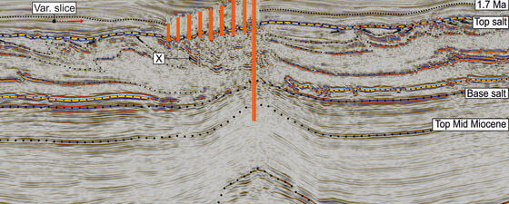
A study published by the University of Oxford in 2018 (Cartwright et al.) used available seismic data to identify multi-episode fluid expulsion in the Lebanese offshore. The study identified a suite of linearly distributed trails of fluid escape pipes with pockmarks at their upper terminus. The pipe trails are oriented orthogonal to the strike of the pre-salt folds, with a synchronous initial expulsion episode in each trail dated at ~1.7 Ma. The reservoir pressure is reported to have charged the structure-to-fracture gradient 21 times. A total trail of 21 pipes and pockmarks are identified overlaying a pre-salt anticlinal structure which highlights the continued generation of hydrocarbons below the North Levant Basin.
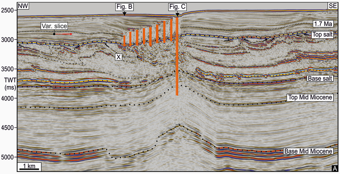
Figure 2: Multi-episode fluid expulsion identified offshore Lebanon. Source: Joe Cartwright; Chris Kirkham; Claudia Bertoni; Neil Hodgson; Karyna Rodriguez, 2018.
Well 16/1, drilled offshore Lebanon reinforces this concept. As reported by the operator, the well contained traces of gas confirming the presence of a hydrocarbon system, but it did not encounter any Tamar Formation reservoirs, which were the main target of the exploration well.
The Lebanese Petroleum Administration (LPA) performed a parallel study that resulted in the following findings:
- the hydrocarbon system was proved to be functional;
- formation tops, breaks in deposition and ages were identified from biostratigraphy and mineralogical analysis;
- carbonate units are predominant in the zone around the well; and
- different types of source rocks were identified, including the potential for having both oil and gas offshore Lebanon.
Further studies are being conducted to adapt the previously used siliciclastic model to the actual carbonate environment discovered. These converged with the findings reported by the operator, based on geological and petrophysical analysis. However, further work is being conducted to understand the geological environment in which a potential reservoir could be located, by performing seismic interpretation and developing an elaborate sequence stratigraphy model.
As part of a second Exploration and Production Agreement signed in 2019 by Total E&P Liban Sal, the operator of the international JV, a second well is expected to be drilled in Block 9 in the upcoming year that is more proximal to proven discoveries in the south, such as Tamar, Leviathan, Karish and Aphrodite. Recent appraisal activities in Karish – ~2 km south of the Lebanese border – indicate porosity reaching up to 20% in the targeted sand formations with the presence of both gas as well as light oil and condensate, significantly enhancing the prospectivity of offshore southern Lebanon.
Geological Zones Offshore Lebanon
Lebanon’s offshore has been separated into three main geological domains:
- the deep basin;
- Latakia Ridge; and
- the Levant Margin.
Each of these domains is marked by a general structural style, and various stratigraphic architectures, resulting in different source-reservoir-trap configurations. This subdivision into domains can impact exploration as it highlights specific geographic areas having distinct petroleum systems that can each be considered areas of interest in their own right. The deep basin is ~14 km thick and comprises sediments from the Jurassic to the Pliocene age deposited in a deepwater environment and is composed of hemipelagic shale and intercalated but discrete layers of sandstones which are the potential reservoirs. These sediments pinch-out eastward along the Lebanese continental margin. The Latakia Ridge domain is located in the northwest part of the Lebanese exclusive economic zone and is characterized by large SW–NE-oriented compressional structures with reverse faults and deep thrusts that are still active at the present time. The Levant Margin is comprised of the Mesozoic platform, which is characterized by thick shallow-water platform carbonates of Triassic to Middle Cretaceous age and the Neogene continental platform which is superimposed on the Mesozoic platform, and is comprised of Late Miocene and Plio-Quaternary sediments.
Figure 3: Geological domains of offshore Lebanon. © LPA.
Lebanon is surrounded by proven hydrocarbon discoveries to the west and south, including the offshore fields Tamar, Leviathan, Aphrodite, Zohr and Calypso, as well as the many other discoveries onshore to the east in the Palmyrides. The Lebanese Basin is ideally situated for hydrocarbon exploration, lying as it does in an area proven to have favorable trap, reservoir and source rock combinations with the potential for mixed biogenic and thermogenic systems offshore Lebanon.
A Wealth of G&G Data Offshore Lebanon
Hydrocarbon exploration in Lebanon is expected to move at a fast pace due to the accessibility of extensive geophysical data, which was made available before the closure of the first offshore licensing. This remarkable and possibly unique situation means that this wealth of information will allow stakeholders to learn a lot about the offshore hydrocarbon potential of the area, right up to prospect level, ahead of the important, decision-making processes inherent in the industry.
Specifically, more than 14,000 km and more than 15,000 km2 of high quality 2D and 3D seismic data is available for licensing in Lebanon. Coupled with this extensive geophysical coverage, the data derived from the well provides invaluable information for stakeholder analysis.
What Next for Hydrocarbon Exploration in Lebanon?
It is generally known in the industry that the Probability of Success (POS) of hitting a discovery from the first exploration well is less than 30%. Given this context, the exploration well marked a significant milestone that reiterates Lebanon’s commitment to develop its prospective offshore petroleum sector for the benefit of current and future generations, keeping in mind that the oil and gas sector is inherently associated with risks and uncertainties. Persistent efforts will continue to achieve the long-term vision of the sector.
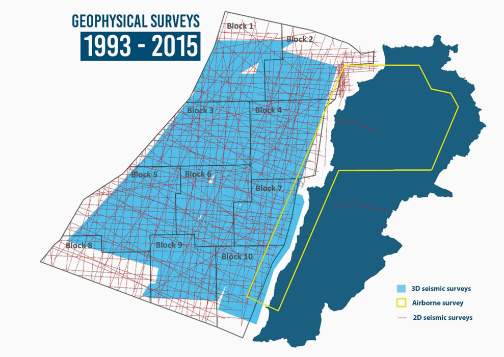
Figure 4: High quality geophysical data available over the offshore area. © LPA.
In addition to the scheduled second well to be drilled in Block 9, the Lebanese government approved the launch of the Second Offshore Licensing Round. The Ministry of Energy and Water and the Lebanese Petroleum Administration are working on the marketing of this round and are communicating with companies that expressed interest in taking part in it, including answering questions and providing clarifications about the procedure with which to submit applications. A recently approved draft decree allows companies to securely submit online applications for the Second Offshore Licensing Round.
As the pandemic continued to spread around the world, it had a devastating effect on the petroleum sector from low demand for oil and gas products to a sharp decline in hydrocarbon prices. While the Covid-19 pandemic affected the financial and logistical capacities of petroleum-exploring companies, the decline in oil and gas prices led companies to lower their investments and to hold off exploration activities. Many countries have either postponed or put on hold their licensing rounds, which they had launched before the pandemic. As the conditions described above took their course, it was necessary to momentarily postpone the deadline for the submission of applications to participate in the Second Offshore Licensing Round to a later date which will be determined by a decision that the Minister of Energy and Water will make based on the recommendation of the Lebanese Petroleum Administration. The objective is to engage with the industry to find a suitable closure date for the Second Offshore Licensing Round.
Meanwhile, in light of these changes the level of companies’ interest will be evaluated through direct communication, and the Second Offshore Licensing Round’s general framework will be studied while considering the inclusion of any amendments deemed necessary for the rules of participation in this round in order to keep pace with the new global situation.
References
Cartwright, J., Kirkham, C., Bertoni, C., Hodgson, N. and Rodriguez, K. 2018. Direct calibration of salt sheet kinematics during gravity-driven deformation. Geology, 46(7), pp.623–626, https://doi.org/10.1130/G40219.1.


