AI: Game-Changer in Hydrocarbon Development or Exploration – or Both?
Many may argue about the best use for Artificial Intelligence: is it in the exploration or the development of oil and gas resources? This article illustrates with case studies that AI sits comfortably in both, and forms a bridge between the two, allowing interpretation continuity.
There is no doubt that Artificial Intelligence (AI) has a significant future in the energy business, whether it be in oil and gas or the renewables sectors. The need for a quick, accurate and reliable interpretation tool would help exploration and development teams worldwide, especially as datasets become more extensive and the geotechnical challenges become more complicated.
The benefits of AI for exploration studies are relatively straightforward to identify, as large datasets are becoming common workspaces. Naturally, these substantial datasets are going to require a significant amount of time to interpret, for the immediate purpose of a petroleum system analysis. So, having the ability to interpret the geology quickly through the medium of AI can speed up an interpreter’s workflow. Another benefit of AI is its ability to interpret across the entire seismic cube with the same vigour from section to section. It has infinite stamina, so a strong level of consistency is held across the volume. It is important to note that AI is not here to replace a geologist or geophysicist but enables them to be more efficient with their time. The best integrated AI seismic solutions harness the knowledge and present the opportunity to learn and do more, providing support when users need it most. In this way, interpreters can add more value to the business by a more thorough understanding, drive operator growth through new levels of decision-making and more confidently outline the difference between a good and bad prospect.
Surely, It’s All Geology: Exploration, Appraisal, Development?
Development and exploration interpretations primarily differ in scale and interpretation density. Both workflows require an accurate interpretation of structures but for very different purposes. Exploration studies aim to identify the way hydrocarbons migrate into traps, either structurally or stratigraphically over large datasets, and the possibility of a subsequent leak. In comparison, development studies are more focused on individual structural features, as the aim is to get the hydrocarbon fluids out of the trap in a safe manner, so an increased level of detail is required. Both environments are illustrated below. One case study focuses on the Southern North Sea (SNS), where a regional mega-merge dataset has been investigated using AI fault interpretation tools, to gain an understanding appropriate for regional petroleum system analysis. The development case study looks at a Central North Sea (CNS) field focusing on the importance of structurally constrained reservoir connectivity and the implications for future well planning.
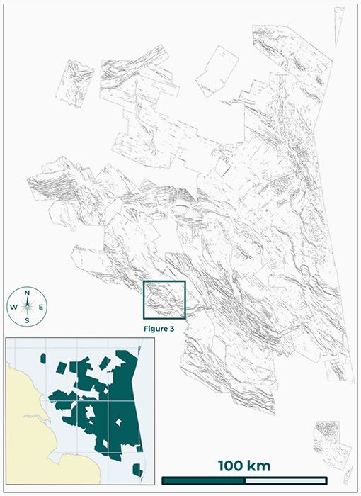
Figure 1: Time slice at 800 ms of AI fault confidence throughout the SNS mega-merge dataset. © Geoteric.
Exploration: Southern North Sea Case Study
The SNS mega-merge dataset (available through the UK National Data Repository) is a regional volume which spans 78,000 km2 across the UK sector of the Southern North Sea (Figure 1). The benefit of having such a large dataset is that it allows interpreters to better understand the interaction and interplay of geology across vast areas that may have otherwise been limited by licensing restrictions or data availability. This enables interpreters to identify and interpret key components of the petroleum system, such as hydrocarbon kitchen areas and structural closures. The time slice image through the SNS (Figure 2) highlights a number of these critical events. Several structures can be identified, such as the Dowsing Graben System and crestal faulting above salt diapirism. The structures are revealed throughout with equal consistency, something difficult for a human to achieve, as AI does not suffer from interpretation fatigue, nor is it influenced by mood or external pressures. The ability to reveal the entire structure and better understand the impact of the faulting can be fundamental to a fuller comprehension, as opposed to interpreting only a small seismic cube that only contains a portion of the feature.
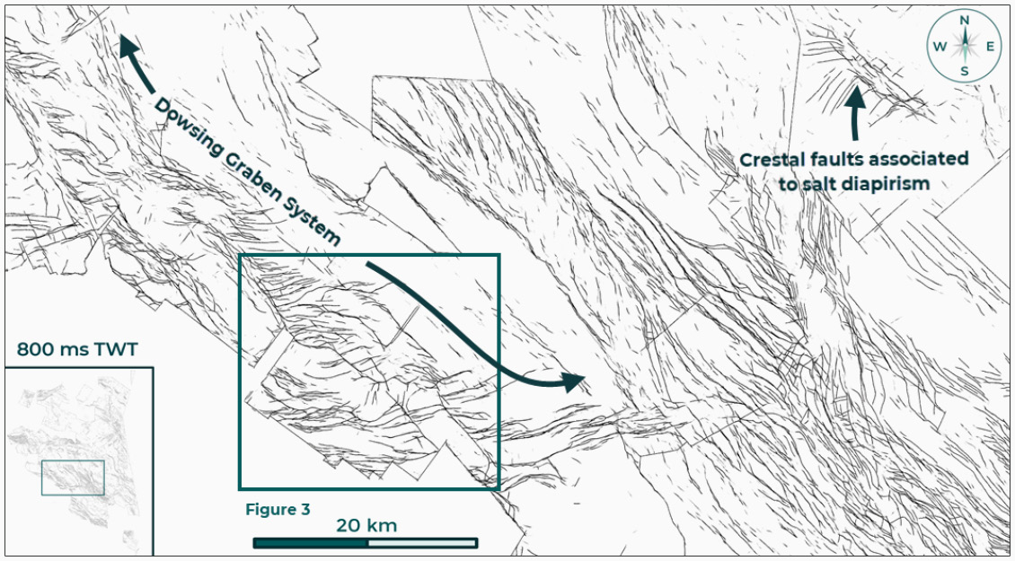
Figure 2: Time slice highlighting the thin-skinned tectonics of the Dowsing Graben System to the south-west of the image. These faults, although post-salt, impact on the deeper petroleum system and their delineation are subsequently important for basin analysis. © Geoteric.
When zooming in over an area of interest (Figure 3) even more detailed structural information is revealed, and by comparing it to gas fields such as Lancelot and Excalibur it is possible to get a sense of scale. By looking at Figure 1, it is clear that this is just a postage stamp of an area on a rather large envelope. However, the detail observed when the fault confidence volume is rendered in 3D is quite spectacular. The complex nature of the faulting is brought out in all of its glory, making subsequent interpretation far more accessible and informative. As we whittle the volume down to that of a development style project, the need for a detailed interpretation does not change; if anything, it becomes even more important. Now that the petroleum system is defined and the highest calibre traps identified, it is all about getting the hydrocarbon fluids out of the ground safely. In doing so, interpretation will become even more focused on fine detail – where the presence of even the smallest fault can play a significant role in fluid transmissibility or reservoir compartmentalisation.
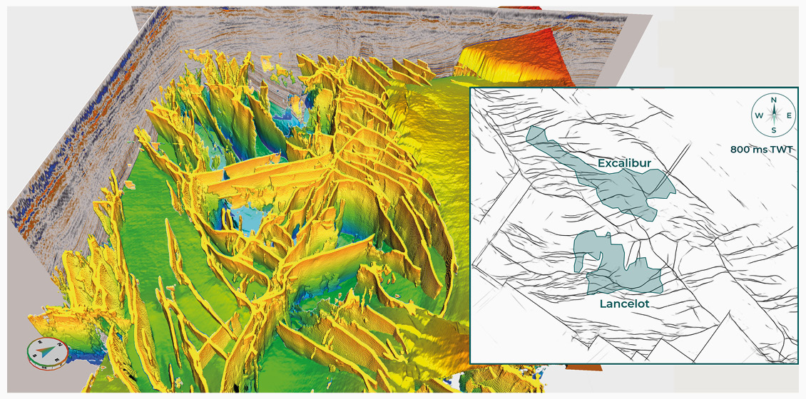
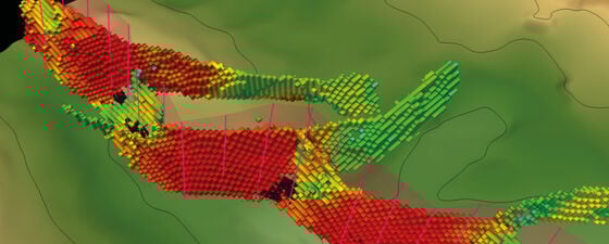
Figure 3: 3D render of the AI fault confi dence volume revealing the detailed faulting in the Dowsing Graben System above the Lancelot and Excalibur fields. © Geoteric.
Development: Central North Sea Case Study
Faulting plays a crucial role with regards to development planning, whether it be the impact of an open or closed fault for fluid flow or the effect of faults on well safety. There are many examples where faults have caused production problems, history mismatching or the collapse of wellbores. This case study illustrates how AI has been used to address some of these issues.
The CNS has a complex geological history with many fields containing elements of extensional rifting, salt halokinesis and shallow soft sediment remobilisation (injectites). The interaction of faulting and salt movement can create a wide range of structural features, some of which can appear unusual. In this case study, the primary trap is a fault-bound structural high containing several faulted panels, which are limited to the east by a stratigraphic ‘scoop’ feature, heavily influenced by the underlying salt movement. Before this study, there were inconsistencies in the structural interpretation of the field, be it inherited from previous operators to variations based on newly acquired/reprocessed seismic data. This makes decision-making very difficult, even more so if there are time pressures associated with licence demands.
The AI fault confidence results are observed in Figure 4, where the original and fine-tuned results are displayed on the top reservoir horizon slice. The foundation network fault confidence results quickly reveal the structures which can then be checked and confirmed as geological structures. The foundation network can be fine-tuned to the style of faulting observed in the dataset using fault stick interpretations to ensure the most geologically accurate results. This interaction between the interpreter and AI is critical to ensuring the best results can be achieved. As should be expected after fine-tuning, some differences can be noted. Firstly, the faults identified appear more confident (redder), and several low confidence (blue) responses in the south-west are removed. Interestingly, one feature identified in the centre of the field has been removed (yellow circle). After reviewing the foundation results, it was deemed that this is not a structural lineament, and as such, was not included in the fine-tuning process.
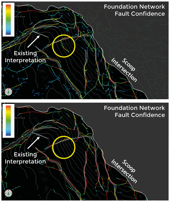
Figure 4: AI fault confidence draped onto the top reservoir horizon. The ‘fault’ highlighted in the yellow circle was removed after finetuning as it was deemed not a structural lineament in the foundation network review. The confidence of the fault responses increases after fine-tuning with the detected faults having a more red response. © Geoteric.
Rendering the results in 3D allows the structural complexity to be uncovered, showing a series of splayed faults (Figures 5A and 5B) which might have been interpreted as a singular fault had traditional interpretation techniques been used. This example illustrates the fine level of detail that can be achieved with AI fault interpretation. This highly accurate interpretation can be used to analyse reservoir connectivity between fault blocks (Figures 5C and 5D). Reservoir connectivity/compartmentalisation is crucial in determining optimal well positioning and future field development. Both the foundation and fine-tuned networks highlight the presence of a relay-ramp structure between these two fault blocks, suggesting the two blocks are in communication. The fine-tuned network creates a clearer image with lower confidence results removed, making the interpretation process considerably easier.
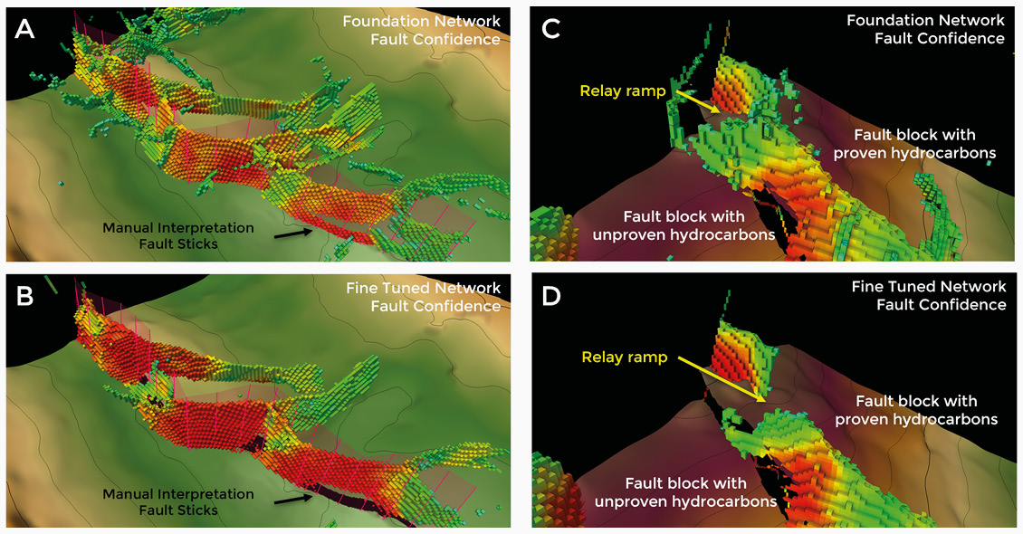
Figure 5: Increased detail can be resolved using AI fault analysis. A series of splayed faults have been identified in the fault confidence volume (A and B), which was interpreted as a single fault using manual interpretation techniques. Figures C and D illustrate the presence of a relay ramp in both AI fault detection networks, which can be used to de-risk the potential of hydrocarbon connectivity between fault blocks. © Geoteric.
Implications for AI Usage
Both case studies illustrate that AI interpretation works for development and exploration. The SNS case study highlighted that the AI results could be used to demonstrate regional structure (Figure 1) and that these results are also beneficial for detecting detailed amounts of fault information (Figure 3). Other benefits include the ability to train or fine-tune the AI network to a specific dataset to improve accuracy, as shown in the CNS case study. AI’s ability to interpret vast amounts of data can free up interpreters to focus on the geologically complex components of the interpretation task.
Retaining high quality interpretation when moving from an exploration setting to a development environment is of significant value. Often, information can get lost or left behind when project transfer occurs; however, an AI fault confidence volume has value in both settings.
The time saved in utilising AI to undertake structural interpretation is twofold. Firstly, it takes considerably less time to start the interpretation work. Secondly, with the time saved, it allows interpreters to absorb the results of the interpretation and incorporate any changes into any existing interpretations/models. Having the time to make informed decisions based on an unbiased study from the seabed to reservoir target can be used for a variety of projects. Whether it be defining kitchen basins, structural highs, migration pathways, trap/seal integrity analysis, shallow hazard detection or well safety, AI fault analysis can be used and fine-tuned to improve the interpretation.
As these case studies show, Artificial Intelligence is the next big game-changer within seismic interpretation.


