Renewed Interest in CSEM in Oil and Gas Exploration
Controlled Source ElectroMagnetic (CSEM) is a proven technique that has a strong future in helping solve certain oil and gas exploration and production challenges, especially when seismic data alone cannot provide a satisfactory answer.
Controlled Source ElectroMagnetic (CSEM) methods have been commercially available to the upstream oil and gas industry for approximately 20 years. Despite a promising start, the method has never been widely used and its popularity has waxed and waned in lockstep with the ups and downs of the oil industry. For this the CSEM industry itself must bear some responsibility.

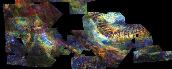
Figure 1: CSEM brings most value when closely integrated with seismic. This example from the Barents Sea (courtesy PGS) demonstrates the improved resistivity resolution that can be achieved by conditioning EM inversion with seismic structure. Multiphysics workflows can then be applied to determine rock and fluid properties.
There are, however, signs of renewed interest in CSEM methods even in these difficult times. As CSEM usage increases again it is important to understand the lessons from the past to ensure a more sustainable future for the technology and to prevent a repeat of wasted effort and money.
Looking at the Past of CSEM
The origins of marine CSEM can be traced back to the Scripps Institution in California, where Professor Chip Cox and his team developed the first marine source and receiver systems in the 1970s. These tools were developed to investigate volcanic fluid systems in the crust and mantle and were deployed around the globe. Exxon was the first oil company to see the promise of CSEM methods for hydrocarbon exploration and filed a patent for the use of this technology in oil and gas in 1981.
November 2000 marks the start of the modern era of CSEM. Statoil (now Equinor) funded a survey in Angola, employing receivers from Scripps (now under the direction of Professor Steve Constable) and using an active CSEM source developed by the team at Cambridge University in the UK, led by Professor Martin Sinha and Dr Lucy MacGregor. Also onboard were geoscientists from Statoil, including Dr Svein Ellingsrud. This survey attempted to ‘locate’ a known hydrocarbon reservoir, which it duly did, leading to a rapid expansion of the industry.
Almost immediately following the Angolan project the Norwegian team founded emgs, the Cambridge team formed Offshore Hydrocarbon Mapping (OHM) and Scripps collaborated with AOA geophysics to form AGO. Within a few years, both emgs and OHM IPO’d for stellar valuations (approximately US$1.5 billion and US$300 million respectively) and AGO was sold to Schlumberger (WesternGeco). Meanwhile PGS acquired the University of Edinburgh spin-out MTEM, along with its marine electromagnetic (EM) technology, and developed this into a new CSEM system in which both the source and receivers are towed behind the survey vessel in a configuration similar to a standard seismic acquisition. This innovation, one of the most significant since Chip Cox’s original surveys of the 1970s and 80s, allows rapid and efficient acquisition of high quality marine CSEM data.
What Went Wrong with CSEM?
This activity should have been the start of a golden age of marine CSEM – but alas not. Within a few years, Schlumberger had shut down their CSEM business, emgs saw its market capitalisation collapse, and OHM’s acquisition capability was sold off to emgs, whilst OHM’s analysis and interpretation capabilities were merged with Rock Solid Images.
What went wrong? A number of factors caused the erratic commercial performance of CSEM in upstream oil and gas. It appears that CSEM was “over promised and underdelivered”– never a good recipe for success. The method was sold as a magic bullet, even as a replacement for seismic (hence the initial huge valuations). In addition, CSEM applications to reservoir mapping were at the start of their development. Expertise resided in only a few commercial organisations and universities and little or no commercial software was available for processing and interpreting CSEM data. Patent wars also played a part. The major players embarked on a series of tit-for-tat patent wars, which proved enormously costly and confused and distracted clients – enriching no one but the patent attorneys.
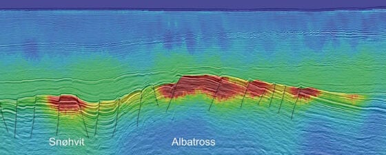
However, perhaps the biggest mistake was an unwillingness to accept that CSEM works best when integrated with seismic. In the early days of CSEM adoption, data were often analysed in isolation, leading to ambiguous results. On survey after survey, careful analysis has highlighted the value of the close integration of CSEM and seismic (Figure 1). This has not been well communicated by the providers of CSEM data.
The Current CSEM Industry
Yet despite these both self-created and existential challenges, the CSEM industry remains intact: the lights are still on, even if dimmer than we would like. What is the present state of play?
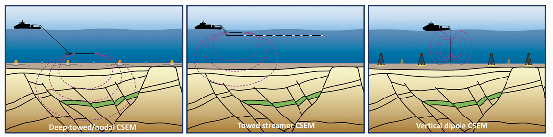
Figure 2: Three approaches to marine CSEM acquisition are now available. Left: Seafloor deployed receivers and a deep-towed EM source is the ‘classic’ approach to acquiring data. Centre: The towed streamer EM system allows rapid acquisition of data since both source and receivers are towed behind the survey vessel. It is applicable in water depths less than about 500m. Right: The vertical dipole system uses seafloor deployed receivers and stationary transmission stations. Figure redrawn from MacGregor and Tomlinson, 2014, Interpretation, 2, AH13–AH32.
The marine seismic acquisition business is now a shadow of its former self. To a large extent the CSEM industry has been affected by exactly the same challenges of low service demand seen by the seismic industry. There have only ever been a small number of CSEM acquisition contractors to the oil and gas industry and a variety of acquisition strategies have been applied (Figure 2), each with pros and cons which must be weighed up when designing an acquisition campaign. The remaining contractors include:
- emgs. Though their vessels are cold-stacked, emgs retains the world’s largest fleet of seafloor deployed CSEM receivers and owns a sophisticated source technology and also algorithms for inversion and interpretation.
- Allton (formerly Petromarker). Allton promotes an alternative seabed nodal system, using vertical source and receivers.
- Ocean Floor Geophysics. OFG has a long track-record in providing a basket of subsea geophysical measurements including towed, nodal and AUV-mounted marine EM for mapping hydrates and seafloor massive sulphides. In 2020, OFG acquired the rights to the PGS towed-streamer CSEM acquisition system, and related interpretation tools.
On the client side, CSEM surveys are under consideration in a number of areas including Australia’s North West Shelf, South East Asia, Southern Africa, the Mediterranean and the Gulf of Mexico.
Future Outlook of CSEM
Let’s go back to first principles. When a well is drilled and logged, we investigate the borehole using a variety of different physical measurements including both acoustic and electrical tools (Figure 3). Indeed, the sonic and resistivity logs are two of the most important tools a petrophysicist will look to in order to understand the lithology and fluid characteristics of the reservoir and its surroundings.

Figure 3: Well log analysis is inherently a multiphysics process. Measurements of a range of physical properties are integrated in petrophysics and rock physics workflows in order to interpret the lithology and fluid properties of the subsurface. The advent of EM methods allows a similar multiphysics approach to be applied to geophysical data, leading to more robust interpretations of the subsurface. Further details of the example shown can be found in Alvarez et al., 2017, Interpretation, 5, SE43–SE60.
When it comes to surface remote sensing methods, the tool of choice is an acoustic method: seismic. However, we now have an option to acquire CSEM data which, if properly acquired and processed, yields a complementary resistivity section. This can be interpreted alongside seismic in much the same way as a petrophysicist would combine sonic and resistivity data from well logs. CSEM-derived resistivity data is “just another attribute” and can be used with seismic attributes (such as AVO and impedance attributes) to constrain an interpretation of the saturation and pay of a target horizon. The caveats remain; there is no magic bullet, and interpretation uncertainties will always exist (Figure 3).
We need to move away from the phrase “I don’t believe in CSEM”. CSEM is not a belief system or a religion, it is a scientific method built upon Maxwell’s equations, which underpin most of the technology we use in our modern world. Like any tool, it can be misused, but the CSEM industry is now capable of delivering robust resistivity data for a range of oilfield applications. CSEM data is real data; it is different from and complementary to seismic data and can add significant value.
Looking to the future, CSEM is a proven technology that should be routinely considered to help solve certain classes of exploration and production challenges, especially when seismic data alone cannot provide a satisfactory answer. In areas where seismic data already exists, CSEM data can be added to provide additional information that helps define the presence and quality of hydrocarbons. In such areas, CSEM and legacy seismic data may be more cost effective than new seismic data acquisition, and may offer a lower environmental footprint.
Here’s to another 20 years of CSEM!